florida

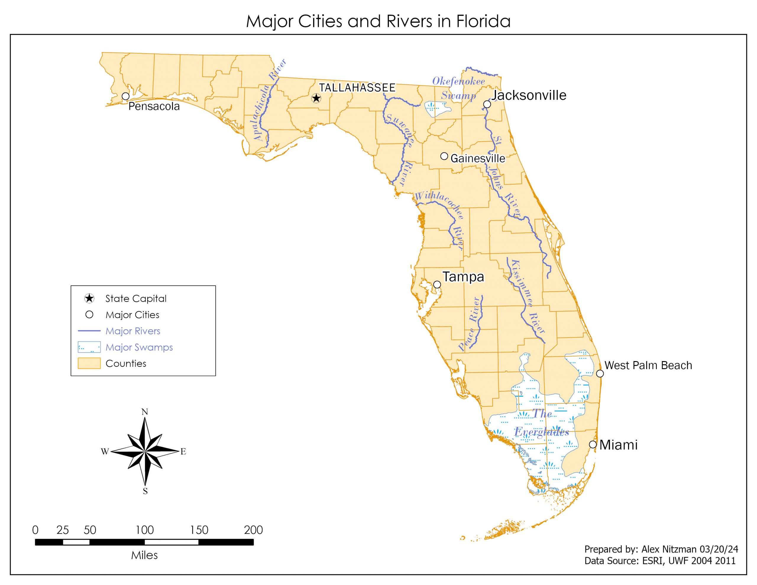
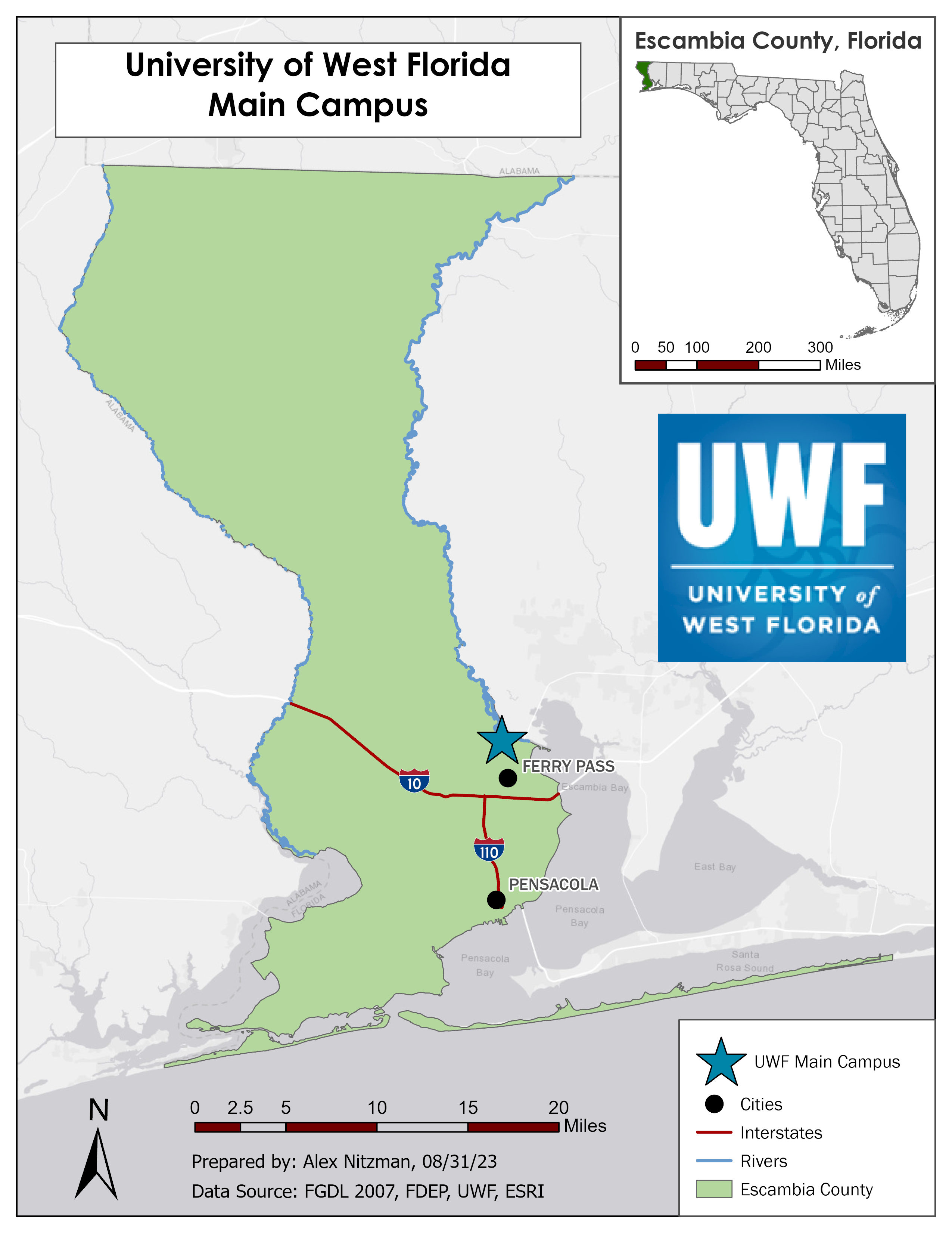
Cartographic Design – Gestalt Principles of Perceptual Organization

Module 3 for Computer Cartography builds on Module 2, where we started developing a routine for good map design with guidelines for labeling, annotation and layout text. Building upon that knowledge base, we focus on cartographic design, the method with which maps are conceived and created. The Gestalt Principles of perceptual organization factor into the design process for the Module 3 lab assignment. There are several key concepts integral [...]

By |2024-04-08T11:02:43-04:00April 2nd, 2024|GIS|0 Comments

Cartography, Designing a good map

The second module for Computer Cartography expounds upon some of the lessons learned from the first module. These include a refresher of the essential map elements (map title, scale bar, north arrow [orientation], data source information, etc.) from Introduction to GIS (GIS 4043), and general typography principles in cartography ranging from type placement, variation dependent upon features and appropriate type size. The concept of map clutter from module 1 [...]

By |2024-04-08T10:51:54-04:00March 21st, 2024|GIS|0 Comments

Remote Sensing – Visual Image Interpretation Basics

A short two days following the completion of the Final Project for GIS4043, I am delving into Photo Interpretation and Remote Sensing (GIS4035). The first lab provides an overview on elements of visual image interpretation, with historical black and white air photos of Pensacola Airport and Pensacola Beach in Northwest Florida. The first aspect of aerial photography interpretation references the tone, or the shades of gray from light/white to [...]

By |2023-11-03T16:47:46-04:00October 22nd, 2023|GIS|0 Comments

Bobwhite Manatee Transmission Line Analysis – Final Project

The final project for GIS4043/Intro to GIS conducts analysis on the Bobwhite Manatee Transmission Project in Southwest Florida. Part of the Florida Power & Light (FPL) infrastructure, the 24.5 mile long transmission corridor was developed to serve growing areas of eastern Manatee and Sarasota Counties, including Lakewood Ranch. Additionally the new line offers redundancy during hurricanes, something tested since it was completed with Hurricane Irma in 2017 and Hurricane [...]

By |2023-11-03T16:57:19-04:00October 13th, 2023|GIS|0 Comments

Georeferencing UWF aerials for Eagles nest easement analysis

The sixth lab for Intro to GIS introduces Georeferencing, which transforms raster data such as an aerial photo or a scan of a subdivision plat, to closely match vector data within GIS. I am familiar with Georeferencing from my cartography jobs, where we often acquired subdivision and other development plats and digitized them for updating map products. Georeferencing utilizes control points, which match features on the raster image without any [...]

By |2023-11-03T16:29:37-04:00October 3rd, 2023|GIS|0 Comments

Geocoding Data – Manatee County Schools

This week's lab project introduced me to Geocoding within ArcGIS Pro and some Excel spreadsheet tactics used to prepare the data for it. The focus of this project is to extract the geographic location for Manatee County Schools from the list posted on the Florida Department of Education web site. Started the lab with a simple copy and paste of the schools list, which includes 84 entries ranging from [...]

By |2023-11-03T16:25:09-04:00September 22nd, 2023|GIS|0 Comments

Map Projection Variation with Florida County data

This week's GIS lab delved into map projections, the manipulation of attribute data and the creation of a feature class out of selected data. We were tasked with taking a polygon shapefile of Florida's County Boundaries and reprojecting it from the original Albers Conical Equal Area (Albers) coordinate system to both the State Plane Coordinate System (State Plane Florida North) and the Universal Transverse Mercator (UTM 16 North) [...]

By |2023-11-03T16:12:01-04:00September 14th, 2023|GIS|0 Comments

Cartography Overview – University of West Florida Map

Following several days of anxiousness following the formation and movement of Hurricane Idalia, I finally was able to resume work on the second Lab assignment for GIS4043. This week's focus is on cartographic basics and design, something I have familiarity with having worked for three map companies. However my experience goes back to ArcMap, and the ArcGIS Pro system definitely requires some time investment to acclimate. The general purpose [...]

By |2023-11-03T15:48:12-04:00August 31st, 2023|GIS|0 Comments

17 Years of GIS

I am not new to the GIS world, but have been out of practice for quite some time. First worked with GIS as a researcher and cartographer for Mapsource, Inc. out of St. Petersburg, Florida. Later worked for Universal Map Group, LLC out of DeLand, using GIS exclusively as part of my job as map researcher. Followed those jobs by joining GIS Cartography and Publishing Services, LLC, where I [...]

By |2023-11-03T15:43:54-04:00August 22nd, 2023|GIS|0 Comments

November 2021 Updates

Many updates were made over the last month to the site and are summarized below. We also traveled to Charlotte, North Carolina for a concert, and took some time to check out a few area roads including the tolled Monroe Expressway, U.S. 74 along Independence Boulevard and various state routes in York County, South Carolina. Worked some over the Thanksgiving weekend on some of the recent photos from Carolina. [...]

By |2021-12-01T08:47:19-05:00November 30th, 2021|Arkansas, Florida, Georgia, Kansas, North Carolina, South Carolina, Updates|0 Comments
Go to Top