

California 22 East
| California 22 east | |
|---|---|
 |
In Long Beach, California 22 begins as Seventh Street in Long Beach. The divided highway begins at California 1 (Pacific Coast Highway), then travels east along Seventh Street. This traffic signal, at Pepper Tree Lane, is the final signal along California 22 east before the road transitions into a freeway. A right turn to Silvera Avenue is the last at-grade intersection on California 22 east. A jersey barrier separates the two directions of traffic. Photo taken 11/13/05. |
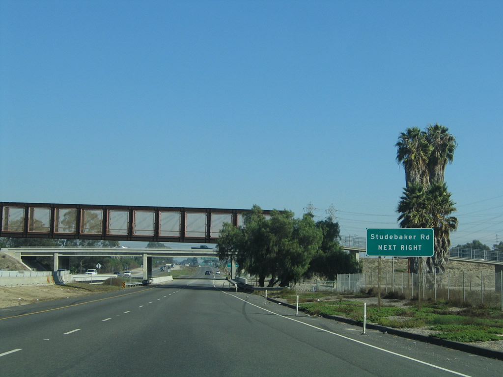 |
The first interchange along California 22 (Seventh Street) east is Exit 1, Studebaker Road. This is the final Long Beach interchange, as California 22 will depart Los Angeles County and enter Orange County upon crossing the San Gabriel River. Photo taken 11/13/05. |
 |
Eastbound California 22 (Seventh Street) reaches Exit 1, Studebaker Road. This is the final Long Beach interchange, as California 22 will depart Los Angeles County and enter Orange County upon crossing the San Gabriel River. Photo taken 11/13/05. |
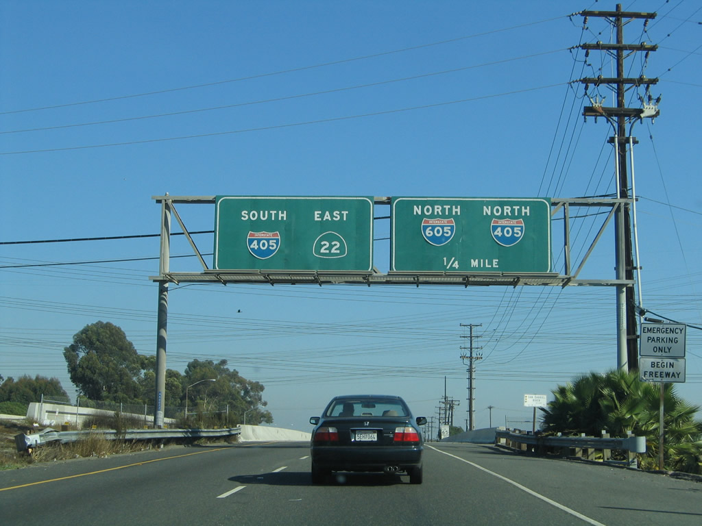 |
The next exit along California 22 east is Exit 2, Interstate 405 (San Diego Freeway) north and Interstate 605 (San Gabriel River Freeway) north. Stay right for the connection to Interstate 605 north; use the left two lanes to continue east on California 22 and south on Interstate 405. Photo taken 11/13/05. |
 |
California 22 leaves Los Angeles County and Long Beach and enters Orange County and Seal Beach (population 24,157 as of 2000 Census; incorporated on October 25, 1915). Photo taken 05/02/10. |
 |
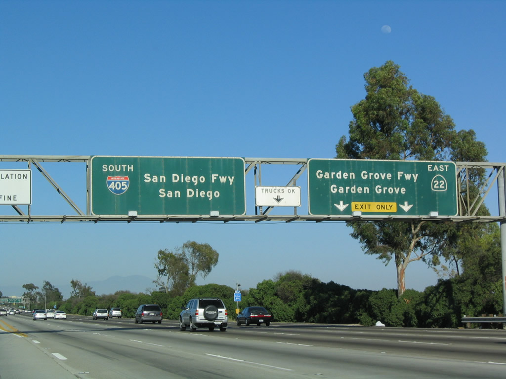
Eastbound California 22 reaches Exit 2, Interstate 405 (San Diego Freeway) north and Interstate 605 (San Gabriel River Freeway) north (two-lane exit). The left two lanes continue east on California 22 and south on Interstate 405. Ahead, the main lanes of California 22 east will merge onto Interstate 405 south. Photo taken 11/13/05. |
 |
The gore point for Exit 2 from California 22 east marks the beginning of Interstate 605 north. Interstate 605 has a brief section between California 22 and Interstate 405 before continuing north on its own. Photo taken 05/02/10. |
| Interstate 405 south & California 22 east | |
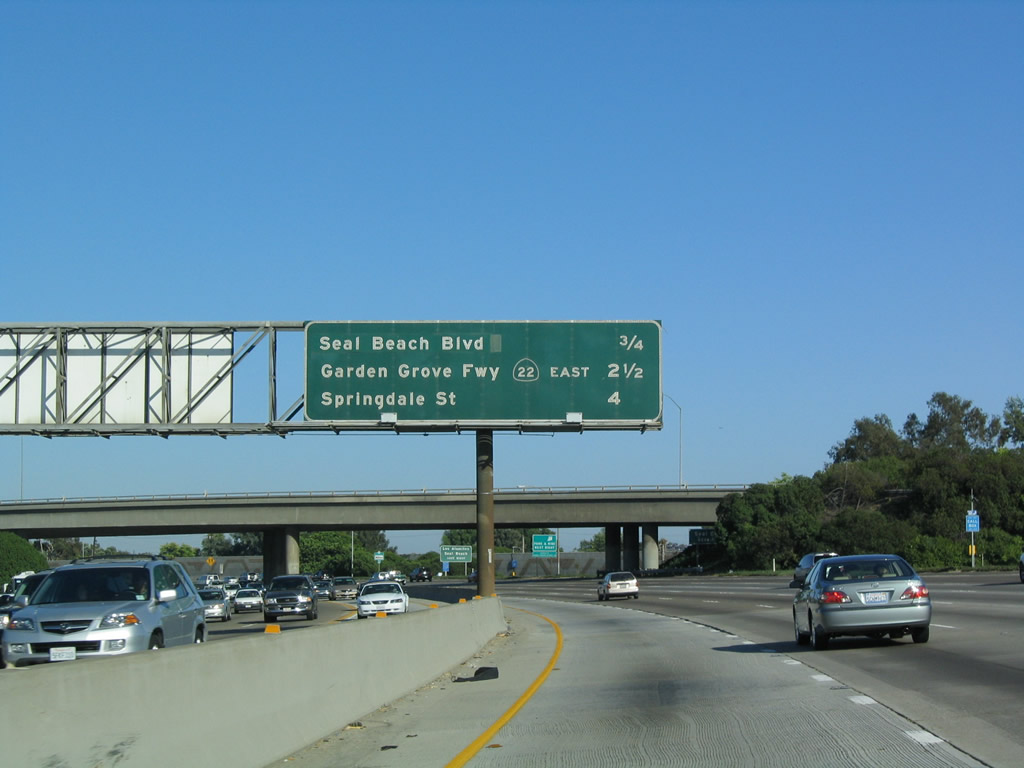 |
This mileage sign along Interstate 405 south and California 22 east provides the distance to Exit 22, Seal Beach Boulevard and Los Alamitos Boulevard; Exit 21, California 22 (Garden Grove Freeway) east; and Exit 20, Springdale Street. Interstate 405 enters the city of Seal Beach (population 24,157 as of 2000 Census; incorporated on October 25, 1915). Photo taken 05/30/04. |
 |
Seal Beach Boulevard leads south to Seal Beach, Seal Beach Naval Weapons Station, and California 1 (Pacific Coast Highway). North of Interstate 405 & California 22, Seal Beach Boulevard changes into Los Alamitos Boulevard, which heads north into Los Alamitos. Photo taken 09/28/08. |
 |
 |
Southbound Interstate 405 (San Diego Freeway) and eastbound California 22 approach Exit 22, Seal Beach Boulevard/Los Alamitos Boulevard, next right. An exit number sign was added here between 2004 and 2009. Photos taken 09/28/08 and 06/17/06. |
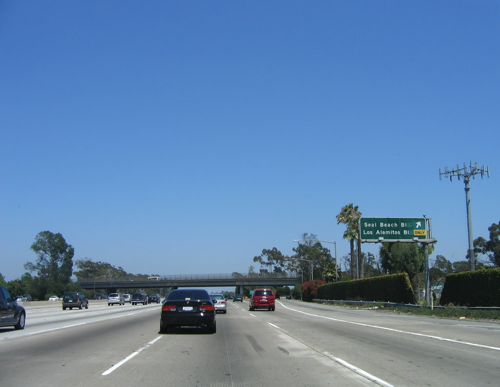 |
Southbound Interstate 405/eastbound California 22 reaches Exit 22, Seal Beach Boulevard (south) and Los Alamitos Boulevard (north). Photo taken 06/17/06. | |
 |
 |
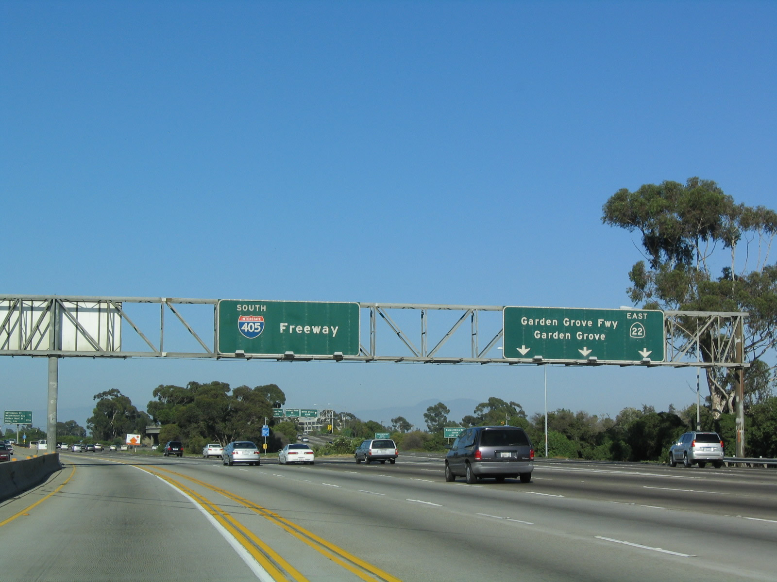
The two freeways prepare to divide at Exit 21. California 22 continues due east, with connections to Interstate 5, California 57, and California 55. Interstate 405 again turns southeast toward Westminster, Fountain Valley, Huntington Beach, Costa Mesa, and Irvine. Photos taken 05/30/04 and 09/28/08. |
 |
 |
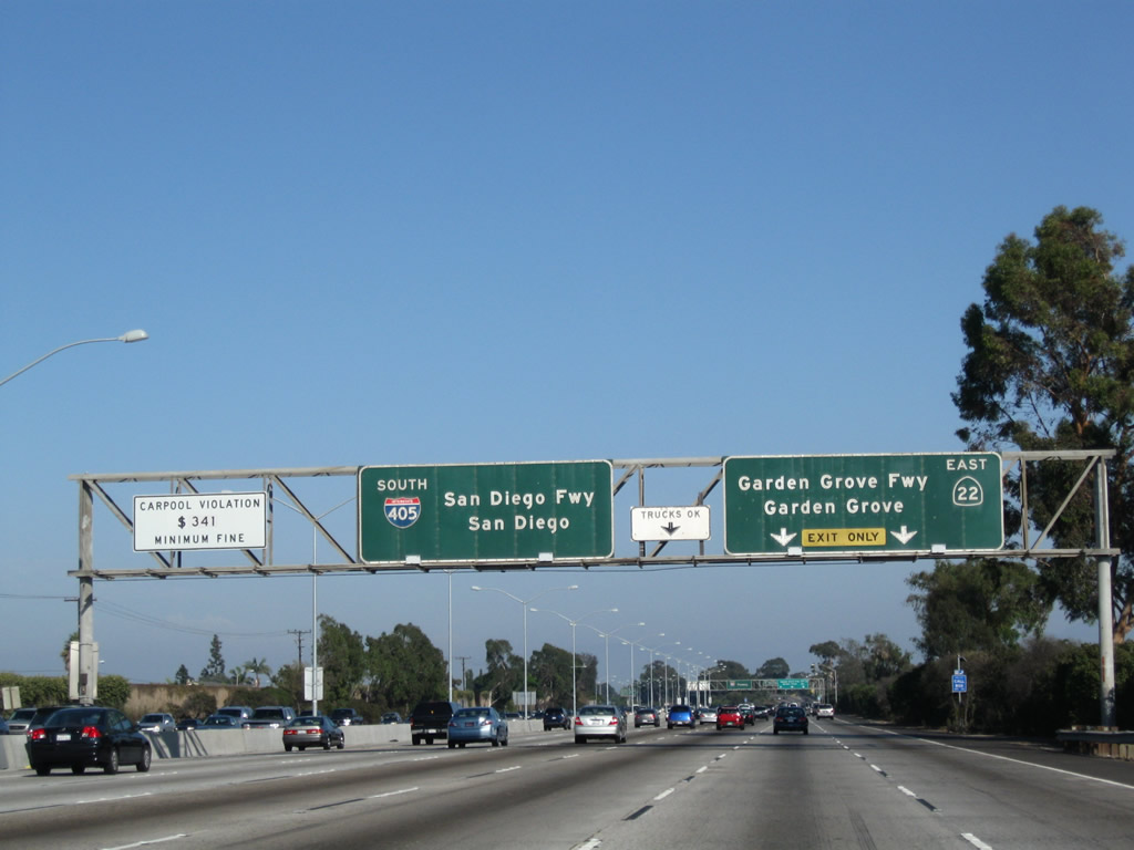
Eastbound California 22 and southbound Interstate 405 split at Exit 21. The four left lanes plus HOV continue south on Interstate 405, while the three right lanes exit onto California 22 (Garden Grove Freeway) east to Garden Grove, Anaheim, Santa Ana, and Orange. From here, Interstate 405 again turns southeast, parallel to the coastline. At this interchange, Interstate 405 leaves Seal Beach and enters Westminster, barely nicking the southwestern corner of Garden Grove. The Exit 21 guide sign was replaced between 2004 and 2008 to include the exit number. Photos taken 05/30/04 and 09/28/08. |
| California 22 east | |
|---|---|
 |
After splitting from Interstate 405, the next exit along California 22 (Garden Grove Freeway) east is Exit 5A, Bolsa Chica Road. The first roadside guide sign advises of pending Exit 5A, which is followed by Exit 5B, Valley View Street. Photo taken 09/28/08. |
 |
The second exit from California 22 east is Exit 5B, Valley View Street. An add-on tab was placed on the roadside guide signs for both Exits 5A and 5B. Photo taken 09/28/08. |
 |
Eastbound California 22 reaches Exit 5A, Bolsa Chica Road. The next exit is Exit 5B, Valley View Street. Photo taken 09/28/08. |
 |
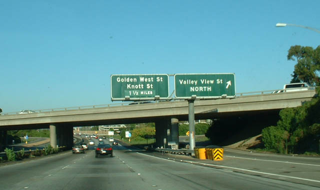 |
Immediately thereafter, eastbound California 22 (Garden Grove Freeway) reaches Exit 5B, Valley View Street. The next exit along eastbound California 22 is Exit 7, Knott Street/Golden West Street. Photos taken 09/28/08 and 08/02/03. |
 |
A California 22 east reassurance shield is posted after the on-ramp from Valley View Street. Photo taken 09/28/08. | |
 |
 |
The next exit along California 22 east is Exit 7, Knott Street and Golden West Street. As a result of freeway reconstruction, the mileage sign previously located here was removed. The mileage sign used to provide the distance to the next two interchanges on California 22 east: Exit 7, Knott Street and Golden West Street and Exit 8, California 39 (Beach Boulevard). Photos taken 09/28/08 and 08/02/03. |
 |
As part of freeway reconstruction, a new carpool (high occupancy vehicle) lane was added to both directions of California 22. A carpool lane entrance is located between the Valley View Street interchange (Exit 5A) and Knott Street (Exit 7). Photo taken 09/28/08. | |
 |
The next exit along eastbound California 22 (Garden Grove Freeway) is Exit 7, Knott Street/Golden West Street. Knott Street leads north toward Buena Park. Golden West Street leads south toward Huntington Beach. This sign was located near the carpool lane entrance and is now gone. Photo taken 08/02/03. | |
 |
A newer mileage sign provides the distance to the next two exits on California 22 (Garden Grove Freeway) east: Exit 7, Knott Street and Golden West Street and Exit 8, California 39 (Beach Boulevard). In addition to Knott Street and Golden West Street, this exit also leads to Garden Grove Boulevard, which parallels California 22 between Exits 7 and 13A, passing through the central part of Garden Grove. Photo taken 09/28/08. | |
 |
 |
Eastbound California 22 reaches Exit 7, Knott Street and Golden West Street. As the name implies, Knott Street leads to Knott's Berry Farm, a locally popular amusement park situated between Knott Street and California 39 (Beach Boulevard) between Lincoln Avenue and California 91 (Artesia Freeway) in Buena Park, north of here. Photos taken 09/28/08 and 08/02/03. |
 |
Upon exiting from California 22, motorists may choose between Garden Grove Boulevard (old California 22), Knott Street, and Golden West Street. Photo taken 09/28/08. | |
 |
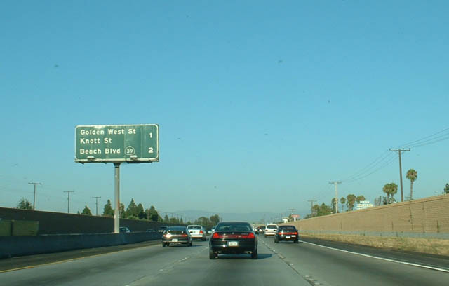
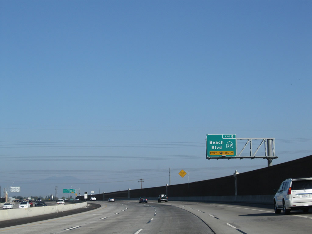
The next exit along California 22 east is Exit 8, California 39 (Beach Boulevard). California 39 travels north to the city of Stanton (population 37,403 as of 2000 Census) and south to the city of Westminster. This interchange was completely revised during reconstruction from a modified cloverleaf to a modified partial cloverleaf. Photo taken 09/28/08. | |
 |
 |
California 22 briefly enters the city of Westminster as we pass through the interchange with Exit 7. A mileage sign provides the distance to the next three exits along California 22 (Garden Grove Freeway) east: Exit 8, California 39 (Beach Boulevard); Exit 9, Magnolia Street; and Exit 10, Brookhurst Street. Each of these exits serve western Garden Grove. Photos taken 09/28/08 and 08/02/03. |
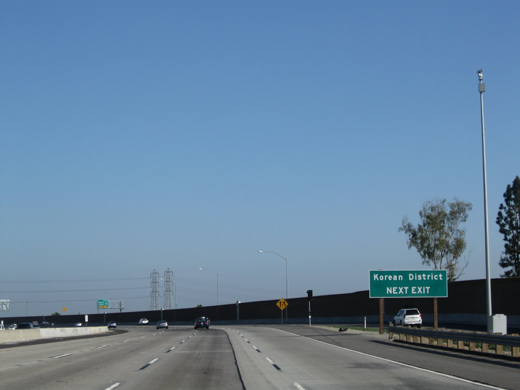 |
Use Exit 8 to the Korean District. Photo taken 09/28/08. | |
 |
 |
The right lane becomes exit only for California 39, which is one of the few remaining state-maintained surface streets remaining in metropolitan Orange County. California 39 follows Beach Boulevard between Huntington Beach and La Habra near the Los Angeles County line, ending at California 72 (former U.S. 101). It is a discontinuous route in Los Angeles County, with one gap between La Habra and West Covina and another gap in the Angeles National Forest before reaching California 2 (Angeles Crest Highway). Photos taken 09/28/08 and 08/02/03. |
 |
 |
Eastbound California 22 reaches Exit 8, California 39 (Beach Boulevard). In the 2003 photo, note the overlay for the California 39 shield; it is not clear what lies beneath the overlay panel (it could have been a white California 39 marker). Photos taken 09/28/08 and 08/02/03. |
 |
 |
Prior to reconstruction, this interchange was a modified cloverleaf. Upon exiting, traffic would enter a collector distributor lane arrangement with two off-ramps, the first to California 39 south and the second to California 39 north. This was eliminated during reconstruction so that all traffic departs the freeway and leads to a signalized intersection with California 39 with options to turn left or right. This change eliminates weaving between entering and exiting traffic. Photos taken 09/28/08 and 08/02/03. |
 |
California 22 passes over California 39 and below a Southern California Edison power line. Photo taken 09/28/08. | |
 |
California 22 leaves the city of Westminster and enters the city of Garden Grove. Incorporated on June 18, 1956, Garden Grove had a population of 165,196 as of the 2000 Census. The city consists of approximately 18 square miles and generally follows the Garden Grove Freeway corridor between Interstate 5 and Interstate 405. Photo taken 09/28/08. | |
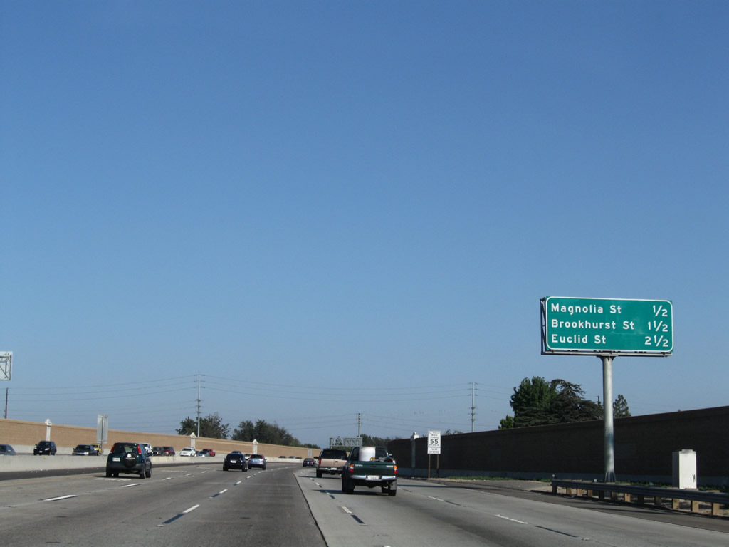 |
This mileage sign provides the distance to the next three exits along California 22 (Garden Grove Freeway) east: Exit 9, Magnolia Street; Exit 10, Brookhurst Street; and Exit 11, Euclid Street. Photo taken 09/28/08. | |
 |
The next exit is Exit 9, Magnolia Street. Magnolia Street leads north to meet Interstate 5 near its interchange with California 91 in Anaheim. Photo taken 08/02/03. | |
 |
 |
Eastbound California 22 reaches Exit 9, Magnolia Street. The next exit is Exit 10, Brookhurst Street, a north-south city street that bisects Huntington Beach, Garden Grove, and Fullerton between Pacific Coast Highway/California 1 and Commonwealth Avenue. Looking at the images from 2003 and 2008, it is clear that quite a few eucalyptus trees were removed in order to accommodate freeway expansion. Photos taken 09/28/08 and 08/02/03. |
 |
 |
This mileage sign along California 22 east provides the distance to the next four exits: Exit 10, Brookhurst Street; Exit 11, Euclid Street; and Exits 12A-B, Harbor Boulevard. Photos taken 09/28/08 and 08/02/03. |
 |
The right lane of California 22 east becomes exit only for Exit 10, Brookhurst Street. Soundwalls have been added along much of the freeway through Garden Grove. Photo taken 09/28/08. | |
 |
 |
Eastbound California 22 reaches Exit 10, Brookhurst Street. Interestingly, the 2003 signs for both Brookhurst Street and Euclid Street indicate that they lead to the City of Garden Grove; clearly the Euclid Street indicator was added to the original sign. Photos taken 09/28/08 and 08/02/03. |
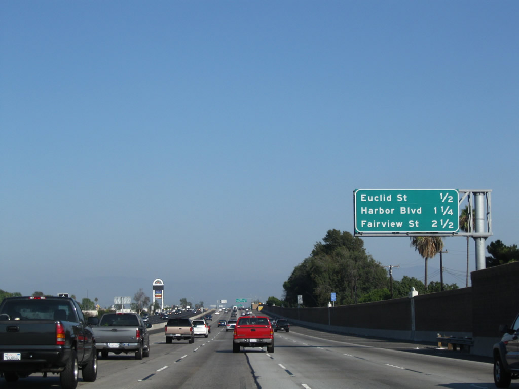 |
This mileage sign along California 22 east provides the distance to the next four exits: Exit 11, Euclid Street; Exits 12A-B, Harbor Boulevard; and Exit 13, Fairview Street. Photo taken 09/28/08. | |
 |
The next exit along California 22 (Garden Grove Freeway) east is Exit 11, Euclid Street to Garden Grove. The city center is located north of the freeway along Euclid near Garden Grove Boulevard. This porcelain enamel sign was removed along with freeway reconstruction. Photo taken 08/02/03. | |
 |
 |
Eastbound California 22 reaches Exit 11, Euclid Street. The next two exits are Exits 12A-B, Harbor Boulevard. Photos taken 09/28/08 and 08/02/03. |
 |
This mileage sign along eastbound California 22 provides the distance to most of the next several exits: Exits 12A-B, Harbor Boulevard; Exit 13, Fairview Street; Exit 14A, The City Drive; Exit 14B, Bristol Street/La Veta Avenue into Santa Ana and Orange; Exit 14C, Interstate 5 (Santa Ana Freeway) south to Santa Ana, San Clemente, and San Diego; and Exit 14D, Interstate 5 (Santa Ana Freeway) north to Los Angeles and California 57 (Orange Freeway) north to Pomona. Photo taken 09/28/08. | |
 |
Eastbound California 22 (Garden Grove Freeway) reaches Exit 12A, Harbor Boulevard south. The exit ramp actually leads onto eastbound Trask Avenue, which then intersects Harbor Boulevard in a signalized intersection. Southbound Harbor Drive leads to Costa Mesa with connections to Newport Beach via California 55. Photo taken 09/28/08. | |
 |
 |
Eastbound California 22 reaches Exit 12B, Harbor Boulevard north. From this interchange, Harbor Boulevard leads north through Garden Grove into Anaheim, where it passes by Disney's California Adventure and Disneyland. Note the changes between 2003 and 2008 as a result of freeway reconstruction. Photos taken 09/28/08 and 08/02/03. |
 |
 |
This mileage sign along California 22 (Garden Grove Freeway) east provides the distance to the next several exits: Exit 13, Fairview Street; Exit 14A, The City Drive; Exit 14B, Bristol Street and La Veta Avenue into Santa Ana and Orange; Exit 14C, Interstate 5 (Santa Ana Freeway) south; and Exit 14D, Interstate 5 (Santa Ana Freeway) north and California 57 (Orange Freeway) north. Photos taken 09/28/08 and 08/02/03. |
 |
 |
A California 22 east reassurance shield is posted shortly thereafter (prior to Exit 13). Photos taken 09/28/08 and 08/02/03. |
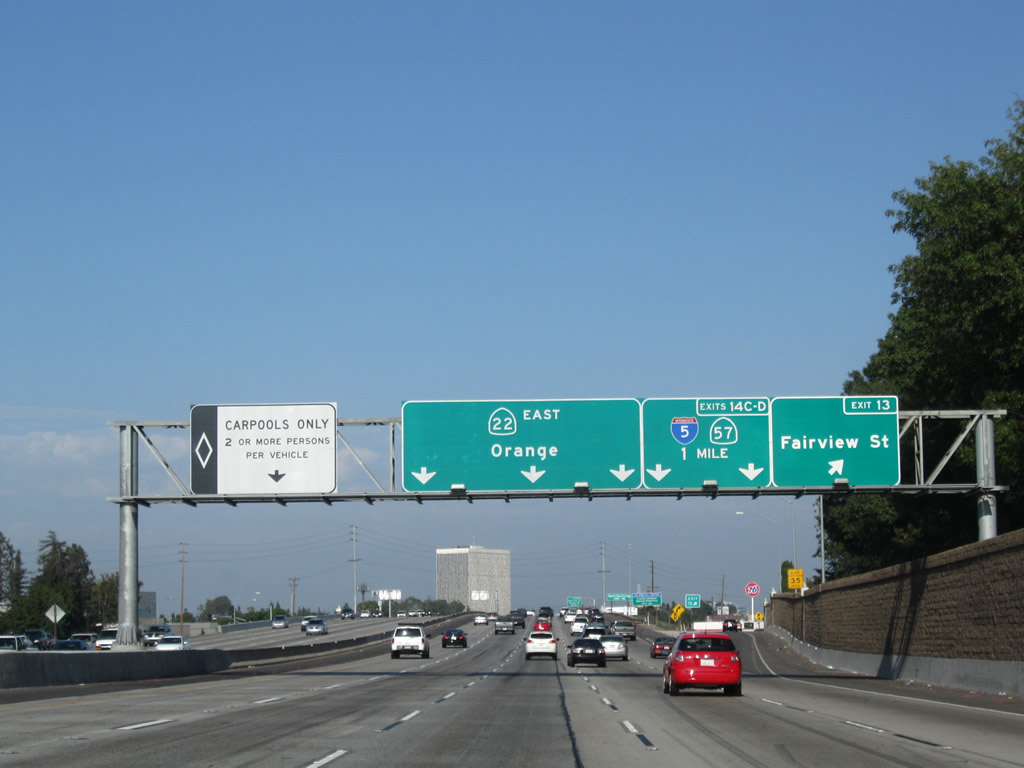 |
Eastbound California 22 (Garden Grove Freeway) reaches Exit 13, Fairview Street. This exit also connects to Garden Grove Boulevard, which parallels California 22 through Garden Grove. Garden Grove Boulevard meets its easterly end at the intersection between Garden Grove Boulevard, The City Drive, and West Memory Lane near the Santa Ana River. This overhead sign omits Exits 14A or 14B in order to advise of the major freeway junction with Interstate 5 and California 57. Photo taken 09/28/08. |
 |
The next exit along eastbound California 22 (Garden Grove Freeway) is Exit 14A, The City Drive. Use The City Drive north to the The Block at Orange, UC Irvine Medical Center, and Angel Stadium of Anaheim. The Crystal Cathedral, a well-known religious landmark, is located northwest of here in Garden Grove. Follow The City Drive north to Chapman Avenue west to the Cathedral. To the south, The City Drive leads to the Santa Ana River and Riverview Golf Course in Santa Ana. Photo taken 09/28/08. |
 |
Use Exit 14B (Bristol Street and La Veta Avenue) to Santa Ana College. Photo taken 09/28/08. |
 |
Although not explicitly mentioned here, California 22 divides into an express/local configuration to serve the next four exits. This configuration was created as part of the reconstruction of the Orange Crush Interchange associated with the California 22 widening in the mid-2000s. Photo taken 09/28/08. |
 |
The right three lanes provide local access to the next four exits: Exit 14A, The City Drive; Exit 14B, Bristol Street and La Veta Avenue into Santa Ana and Orange; Exit 14C, Interstate 5 (Santa Ana Freeway) south; and Exit 14D, Interstate 5 (Santa Ana Freeway) north and California 57 (Orange Freeway) north. Through traffic should stay in the left four lanes (note that the left lane is restricted for carpool traffic). At this point, California 22 leaves Garden Grove and enters the city of Orange, which was incorporated on April 6, 1888 and had a population of 128,821 as of the 2000 Census. The freeway will stay entirely in Orange briefly, then shift onto an alignment that straddles the boundaries of Santa Ana and Orange after passing through the Orange Crush Interchange. Photo taken 09/28/08. |
 |
California 22 divides into express and local lanes as we enter the Orange Crush Interchange (California 22-California 57-Interstate 5). Stay left to continue east on California 22 or merge right onto the collector distributor lanes for the next four exits: Exit 14A, The City Drive; Exit 14B, Bristol Drive; and Exits 14C-D, Interstate 5 (Santa Ana Freeway) south-north and California 57 (Orange Freeway) north. Photo taken 09/28/08. |
 |
Eastbound California 22 reaches Exit 14A, The City Drive, in Orange. The City Drive leads north into Anaheim, where it becomes State College Drive. State College Drive has connections to major league sport facilities, including Angels Field and Arrowhead Pond (home of hockey's Anaheim Mighty Ducks). The next exit is Exit 14B, Bristol Drive, followed by Exits 14C-D, Interstate 5 (Santa Ana Freeway) south-north and California 57 (Orange Freeway) north. Photo taken 09/28/08. |
 |
Looking from the main lanes, the next exit along California 22 east is Exit 14B, Bristol Drive. The right lane becomes exit only for Exit 14B, while the remaining c-d lanes will link with Exits 14C-D, Interstate 5 (Santa Ana Freeway) south/north and California 57 (Orange Freeway) north. Through traffic in the local lanes can return to California 22 at the far side of the Orange Crush Interchange. Photo taken 09/28/08. |
 |
California 22 briefly leaves Orange and enters the city of Santa Ana, which is the seat of Orange County. Santa Ana sits at an elevation of 135 feet, consists of 27.2 square miles, and receives an average of nearly 13 inches of rainfall annually. Incorporated in 1886, Santa Ana became the seat of Orange County when Orange County split from Los Angeles County in 1889. As of the 2000 Census, Santa Ana had a population of 337,977 people; that number climbed to a total of 353,428 per a 2007 California Department of Finance Estimate. The city is 76% Latino or Hispanic per the 2000 Census, and Santa Ana therefore has one of the nation's largest urban populations of that ethnic group. Photo taken 09/28/08. |
 |
Eastbound California 22 reaches Exit 14B, Bristol Drive. The next exits along California 22 east are Exits 14C-D, Interstate 5 and California 57, followed by Exit 15, Main Street. Carpools can merge left to follow the HOV lanes east through Orange and Santa Ana. Photo taken 09/28/08. |
 |
The next exit along California 22 (Garden Grove Freeway) east is Exit 14C, Interstate 5 south to Irvine and San Diego. This busy freeway follows the Santa Ana Freeway to Irvine, then shifts onto the San Diego Freeway from there south to San Diego. Photo taken 09/28/08. |
 |
Eastbound California 22 (Garden Grove Freeway) reaches Exit 14C, Interstate 5 south to Irvine and San Diego. Upon exiting, a ramp connects to Interstate 5's Exit 105B, Main Street and Broadway in Santa Ana. Two lanes connect from California 22 east to Interstate 5 south. The next exit along eastbound is Exit 14D, Interstate 5 north and California 57 north. After the ramp to Exit 14D, the collector distributor lane configuration comes to an end, and all lanes merge back together. Photo taken 09/28/08. |
 |
Immediately thereafter, eastbound California 22 (Garden Grove Freeway) meets Exit 14D, Interstate 5 (Santa Ana Freeway) north and California 57 (Orange Freeway) north. This interchange marks the southern terminus of California 57, a busy freeway that travels north through Anaheim, Fullerton, and Brea before passing through the Puente Hills en route to Diamond Bar and Pomona in Los Angeles County. Interstate 5, meanwhile, travels northwest on the Santa Ana Freeway toward downtown Los Angeles and points north (Sacramento, San Francisco, and all points on California 99). At this point, the collector distributor lanes return to the main lanes, and the dual freeway configuration ends. Photo taken 09/28/08. |
 |
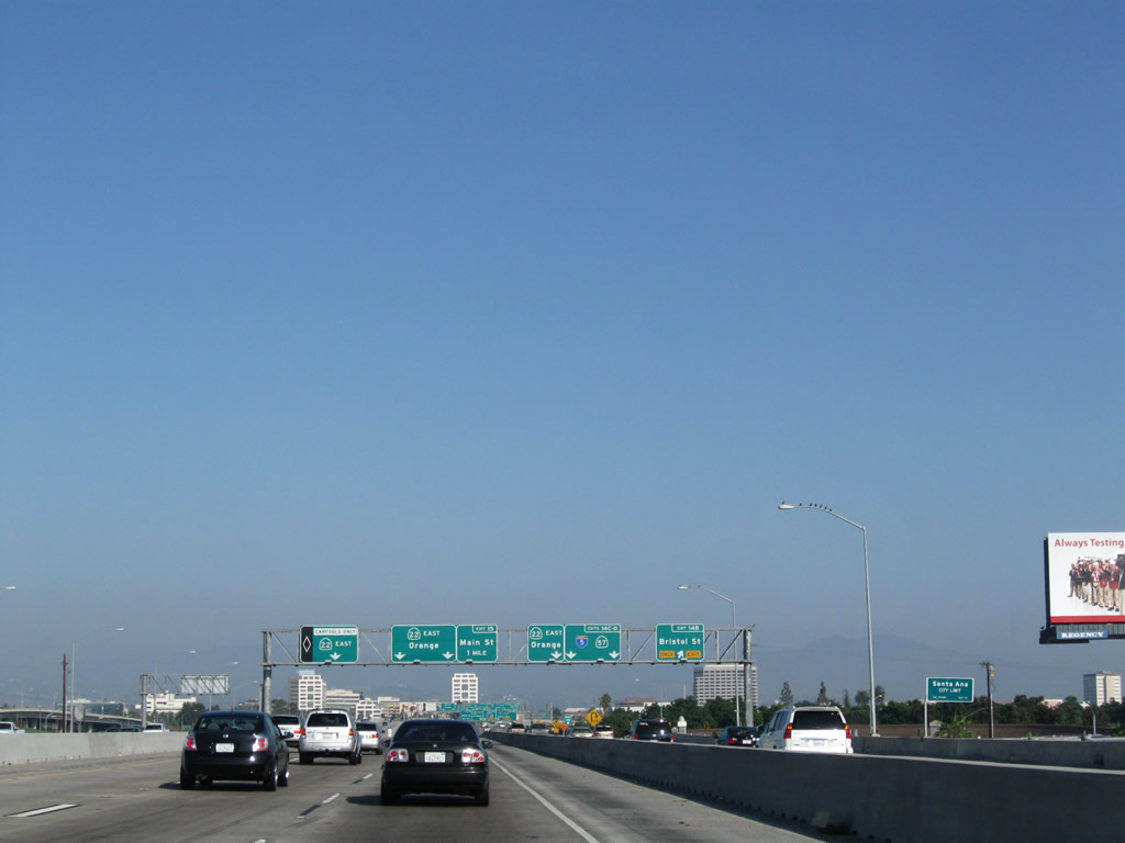
Pulling out of the Orange Crush Interchange, this mileage sign provides the distance to the next three exits from eastbound California 22 (Garden Grove Freeway): Exit 15, Main Street; Exit 16, Glassell Street and Grand Avenue; and Exit 17A, Tustin Avenue. Photo taken 09/28/08. |
 |
Use Main Street south to the Discovery Science Center. The ramp from California 22 east to Interstate 5 and California 57 north passes over the freeway after this sign. Photo taken 09/28/08. |
 |
Straddling the city limits between Santa Ana on the south and Orange on the north, California 22 goes below grade after leaving the Orange Crush Interchange. Traffic from Interstate 5 south merges onto California 22 east at this point. The next overpass carries Bedford Road over the freeway. Photo taken 09/28/08. |
 |
The right two lanes of California 22 east will connect to Exit 15, Main Street. Photo taken 09/28/08. |
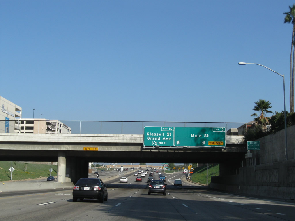 |
Eastbound California 22 (Garden Grove Freeway) meets Exit 15, Main Street. The next off-ramp is Exit 16, Glassell Street and Grand Avenue. An Orange City Limits sign is posted here as well. Photo taken 09/28/08. |
 |
The left four lanes continue east on California 22 (Garden Grove Freeway), while the right two lanes depart to Exit 15, Main Street. Photo taken 09/28/08. |
 |
This mileage sign provides the distance to the final four exits from eastbound California 22 (Garden Grove Freeway): Exit 16, Glassell Street and Grand Avenue; Exit 17A, Tustin Avenue; and Exits 17B-C, California 55 (Costa Mesa Freeway). Photo taken 09/28/08. |
 |
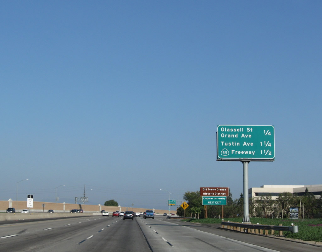
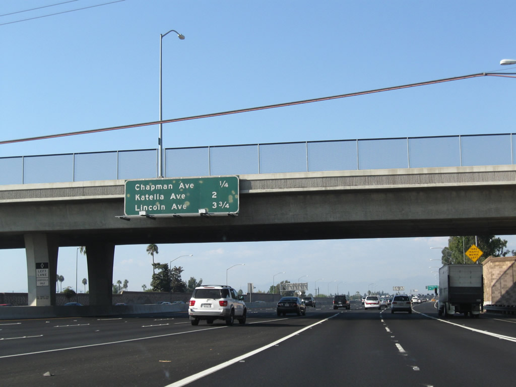
Use Glassell Street north to Old Towne Orange, including Plaza Square Park (traffic circle at the intersection with Chapman Avenue) and Chapman University. Photo taken 09/28/08. |
 |
The right lane of California 22 east becomes exit only for Exit 16, Glassell Street and Grand Avenue. Photo taken 09/28/08. |
 |
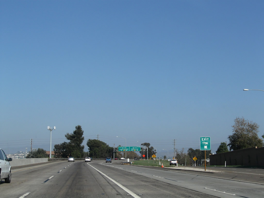
Eastbound California 22 meets Exit 16, Glassell Street and Grand Avenue in Orange. The next exit along California 22 east is Exit 17A, Tustin Avenue. Photo taken 09/28/08. |
 |
The final mile of California 22 sees three remaining exits: Exit 17A, Tustin Avenue; Exit 17B, California 55 (Costa Mesa Freeway) south to Costa Mesa and Newport Beach; and Exit 17C, California 55 (Costa Mesa Freeway) north to Anaheim Hills and Riverside. Photo taken 09/28/08. |
 |
A final mileage sign provides the distance to the last three upcoming exits. At the California 55 interchange, California 22 will come to an end. Photo taken 09/28/08. |
 |
This view looks east along California 22 prior to the Tustin Avenue interchange. Photo taken 09/28/08. |
 |
A California 22 east reassurance shield is posted prior to the off-ramp to Exit 17A. This is the last route marker along eastbound. Photo taken 09/28/08. |
 |
The right two lanes of California 22 east connects to Exit 17A, Tustin Avenue. The left four lanes connect to Exit 17B, California 55 (Costa Mesa Freeway) south to Costa Mesa and Newport Beach and Exit 17C, California 55 (Costa Mesa Freeway) north to Anaheim Hills and Riverside. Photo taken 09/28/08. |
 |
Eastbound California 22 (Garden Grove Freeway) reaches Exit 17A, Tustin Avenue. Continuing east on the mainline, the right two lanes connect to Exit 17B, California 55 (Costa Mesa Freeway), while the left two lanes connect to Exit 17C, California 55 (Costa Mesa Freeway) north. Photo taken 09/28/08. |
 |
The gore point signage for Exit 17A reveals rather large numerals. Photo taken 09/28/08. |
 |
Shortly after the off-ramp to Tustin Avenue, the mainline of California 22 splits. The right two lanes connect to Exit 17B, California 55 south to Newport Beach, while the left two lanes connect to Exit 17C, California 55 north to Riverside. No end shield is present here. Photo taken 09/28/08. |
 |
 |
 |
 |
This series of pictures follows the two-lane transition ramp linking California 22 (Garden Grove Freeway) east with California 55 (Costa Mesa Freeway) north. Photos taken 09/28/08. |

Page Updated November 14, 2010.
|
About Contact Glossary |
In The News Testimonials Interstate Guide |
Social Media:
 |
|
© 2000-23 AARoads.com | All Rights Reserved | Privacy Policy / Terms of Use
|
||