| G Street east |
|
|
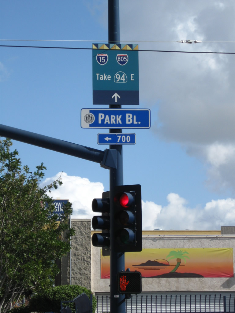
At Park Boulevard (12th Avenue), eastbound G Street crosses the trolley tracks. A wayfinder sign is posted on the traffic signal mast arm directing motorists toward California 94 east en route to Interstate 15 and Interstate 805. Photos taken 01/26/09. |
|
|
Approaching 14th Street in East Village, eastbound G Street has another wayfinder sign on the traffic signal mast arm. What makes this one unique is the old age of the "east" banner that probably dates back to when California 94 was fully signed as a state route along G Street. Photos taken 01/26/09. |
|
Eastbound G Street meets 16th Street at this traffic signal in downtown San Diego (East Village). Photo taken 08/22/04. |
|
G Street carries three eastbound lanes it prepares to transition onto California 94 (Martin Luther King, Jr. Freeway) east from downtown San Diego toward Lemon Grove and La Mesa. Photo taken 08/22/04. |
|
While not a freeway entrance shield assembly, an east California 94 (Martin Luther King, Jr. Freeway) reassurance shield assembly is posted prior to the G Street bridge over Interstate 5. This particular shield is posted on the south side of the freeway entrance. Photo taken 01/26/09. |
|
|
A companion east California 94 (Martin Luther King, Jr. Freeway) reassurance shield assembly is posted on the north side of G Street, next to a street blade assembly for 17th Street (an unsignalized intersection). Photos taken 01/26/09. |
|
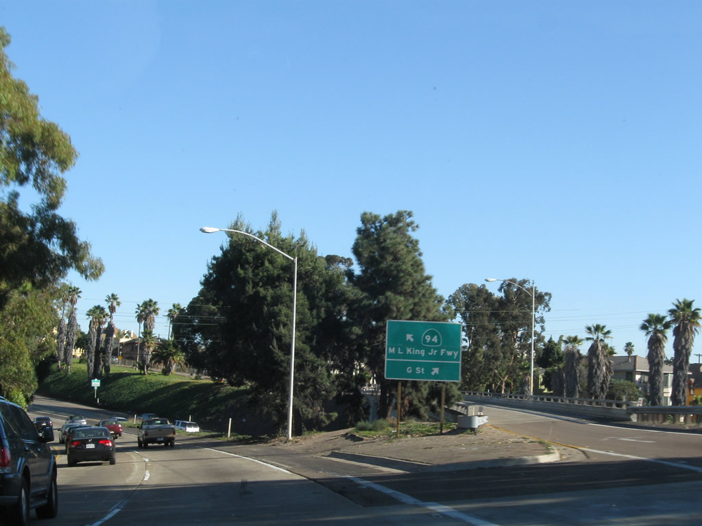
Eastbound G Street transitions onto the California 94 freeway. This is the best route from downtown San Diego to the eastern part of the city and eastern suburbs (Spring Valley, Lemon Grove, La Mesa, El Cajon). This ramp meter light is activated during the afternoon to control the flow of traffic from eastbound G Street onto the California 94 freeway. Photo taken 08/22/04. |
| Transition from Interstate 5 south to California 94 east |
|
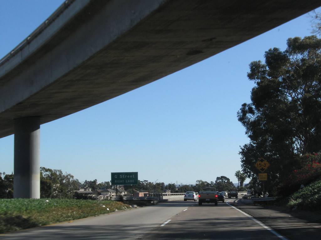
This series of photos documents the transition from Interstate 5 south to California 94. This view shows the two-lane ramp leaving the mainline of Interstate 5; the overpass here is the ramp connecting California 163 and Park Boulevard to Interstate 5 south. There is no direct access from California 163 south to California 94 east except via the downtown street grid (Tenth Avenue south to G Street east). Photo taken 01/28/09. |
|
A second overpass crosses over the transition ramp; this particular overpass connects Interstate 5 south with Pershing Drive north. Originally, this freeway-to-freeway ramp was constructed to connect to the never-built California 171 / Switzer Freeway. California 171 was proposed to travel northeast from downtown through Balboa Park Golf Course and Switzer Canyon in North Park to end at Interstate 805 just south of the Interstate 8 interchange in Mission Valley. A standalone exit ramp from the transition ramp serves G Street east (next right). Photo taken 01/28/09. |
|
|
The two-lane transition ramp follows an elevated viaduct that roughly parallels Interstate 5 south, then swings east to join the Martin Luther King, Jr. Freeway. Downtown can be seen by looking to the right from the transition ramp. Photos taken 01/28/09 and 06/05/11. |
|
At this point, the left two lanes continue onto California 94 (Martin Luther King, Jr. Freeway) east, while the right lane has an optional exit for G Street east into the Sherman Heights neighborhood of San Diego. Photo taken 01/28/09. |
|
The heavily traveled ramp from Interstate 5 south to California 94 east becomes the left two lanes of the nascent Martin Luther King, Jr. Freeway. The right three lanes enter from G Street in downtown San Diego. Photo taken 01/28/09. |
| California 94 east |
|
After traffic from Interstate 5 south and G Street east merge together, California 94 begins its eastbound run toward the eastern suburbs of San Diego. Named the Martin Luther King, Jr. Freeway, California 94 is one of the few freeways to be known for its name as well as its number. Traffic reporters routinely refer to California 94 as the "King Freeway" or as "the 94." Photo taken 08/22/04. |
|
This is the first eastbound reassurance shield for California 94. Note the placard below the state route shield which contains the name of the freeway. Photo taken 08/22/04. |
|
|
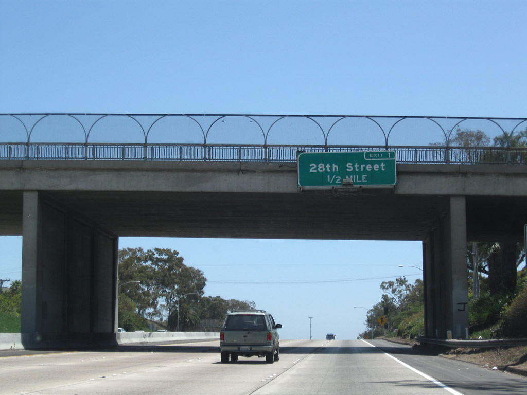
The first exit along California 94 (Martin Luther King, Jr. Freeway) east after the Interstate 5 interchange complex is Exit 1, 28th Street (one-half mile). Photos taken 05/08/09 and 07/14/02. |
|
This mileage sign along eastbound provides the distance to communities east of San Diego. It is located just prior to Exit 1, 28th Street. Photo taken 07/14/02. |
|
Prior to the 28th Street off-ramp is another California 94 east reassurance shield. Photo taken 08/22/04. |
|
Eastbound California 94 (Martin Luther King, Jr. Freeway) reaches Exit 1, 28th Street. Photo taken 01/28/09. |
|
To Interstate 805 north, use California 15 north (Exit 2C). To Interstate 805 south, use Exit 3. Photo taken 08/22/04. |
|
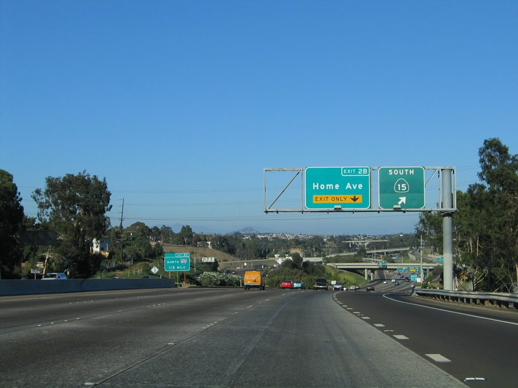
The next exit along California 94 (Martin Luther King, Jr. Freeway) is Exit 2A, California 15 south, followed by Exit 2B, Home Avenue and Exit 2C, California 15 (Escondido Freeway) north to Riverside and San Bernardino. California 15 is considered to be the future alignment of Interstate 15, contingent upon upgrading the California 15 and California 94 interchange to Interstate standards. Such a conversion might include the elimination of the left exits on California 94 and an expansion of through lanes along California 15. This reconstruction is programmed sometime after 2010, contingent upon funding identification. Photo taken 08/22/04. |
|
Eastbound California 94 (Martin Luther King, Jr. Freeway) reaches Exit 2A, California 15 (Escondido Freeway) south to National City and Chula Vista. The next exit is Exit 2B, Home Avenue and the left exit to Exit 2C, California 15 (Escondido Freeway) north to City Heights, Murphy Canyon, Miramar, Rancho Bernardo, and Escondido. Photo taken 08/22/04. |
|
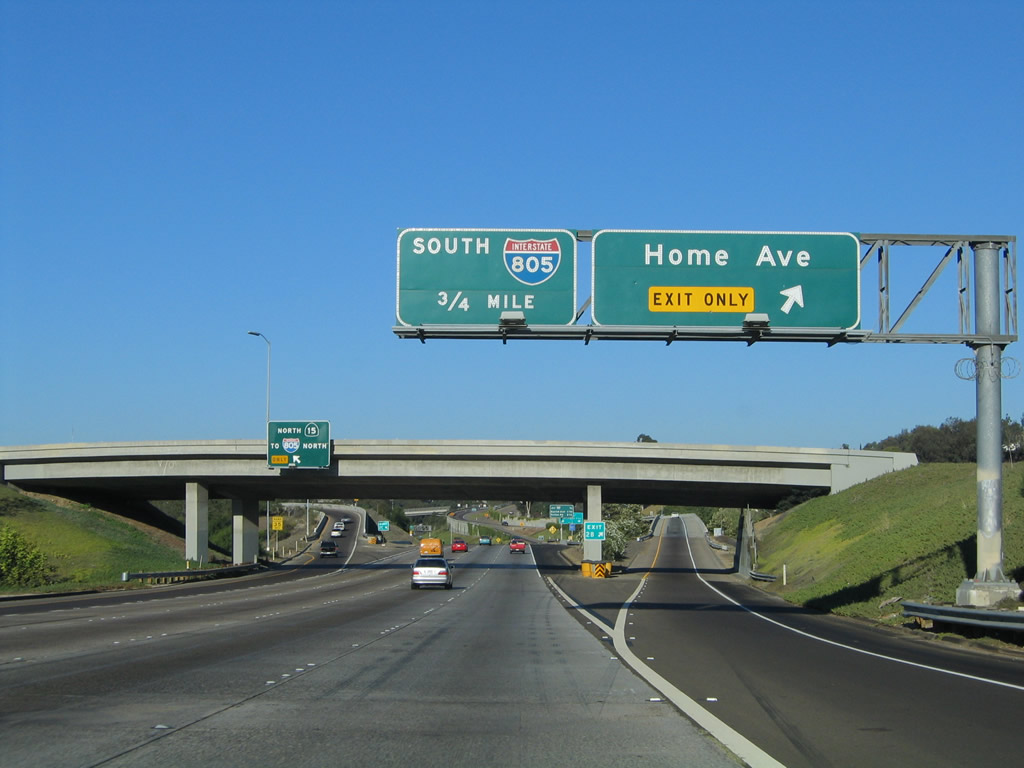
A roadside exit guide sign for Exit 2C, California 15 (Escondido Freeway) to Interstate 805 north to Los Angeles is posted in the median. Photo taken 01/28/09. |
|
On the right side of the freeway is the exit ramp to Exit 2A, California 15 south to National City and Chula Vista. Photo taken 05/08/09. |
|
Immediately thereafter, eastbound California 94 (Martin Luther King, Jr. Freeway) reaches Exit 2B, Home Avenue, followed immediately by the left exit for Exit 2C, California 15 north to Interstate 805 north. There is no direct exit ramp from eastbound California 94 to Interstate 805 northbound, so traffic must use California 15 to facilitate that connection. Photo taken 08/22/04. |
|
|
Eastbound California 94 (Martin Luther King, Jr. Freeway) next meets Exit 2C, California 15 (Escondido Freeway) north to Interstate 805 north. The sign was replaced in 2008 when the old sign was damaged. The new sign shows Interstate 15 rather than California 15 as the signed route. Photos taken 01/28/09 and 08/22/04. |
|
This mileage sign along California 94 (Martin Luther King, Jr. Freeway) east provides the distance to the next three exits: Exit 3, Interstate 805 (Dekema Freeway) south; Exit 4A, Euclid Avenue; and Exit 4B, Kelton Road. Photo taken 08/22/04. |
|
An on-ramp from California 15 north to California 94 east has an off-ramp to Home Avenue. Photo taken 08/22/04. |
|
The new right lane from California 15 becomes exit only for Exit 3, Interstate 805 (Dekema Freeway) south to National City and Chula Vista. Photo taken 01/28/09. |
|
At Exit 3, eastbound California 94 (Martin Luther King, Jr. Freeway) meets the ramp to Interstate 805 south. This ramp also connects to Imperial Avenue. California 94 continues east to Lemon Grove, Rancho San Diego, and Campo. Photo taken 08/22/04. |
|
The two ramps that cross over California 94 at this point carry traffic from Interstate 805 north to California 94 west and Interstate 805 south to California 94 east. Photo taken 05/08/09. |
|
This view looks south from the California 94 bridge down onto Interstate 805. Photo taken 08/22/04. |
|
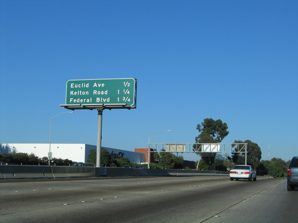
This mileage sign along California 94 (Martin Luther King, Jr. Freeway) east provides the distance to the next three exits: Exit 4A, Euclid Avenue; Exit 4B, Kelton Road; and Exit 5, Federal Boulevard. Photo taken 08/22/04. |
|
Euclid Avenue is a major north-south arterial that extends through portions of San Diego's Mid-City community. Photo taken 08/22/04. |
|
Eastbound California 94 reaches Exit 4A, Euclid Avenue. Photo taken 08/22/04. |
|
The next two exits along California 94 (Martin Luther King, Jr. Freeway) east are Exit 4B, Kelton Road and Exit 5, Federal Boulevard. Photo taken 08/22/04. |
|
This mileage sign provides the distance to the cities of Lemon Grove, La Mesa, and El Cajon via California 94 (Martin Luther King, Jr. Freeway) east. Photo taken 08/22/04. |
|
The next exit along California 94 (Martin Luther King, Jr. Freeway) east is Exit 4B, Kelton Road. Photo taken 05/08/09. |
|
Eastbound California 94 reaches Exit 4B, Kelton Road/Federal Boulevard. Use Federal Boulevard west to reach the community of Webster (still within the city of San Diego). Kelton Road is a favorite name used by several traffic reporters throughout the San Diego region when describing commute conditions on California 94 (MLK Freeway). Photo taken 08/22/04. |
|
The next exit along eastbound California 94 (Martin Luther King, Jr. Freeway) is Exit 5, Federal Boulevard. Photo taken 08/22/04. |
|
Eastbound California 94 (Martin Luther King, Jr. Freeway) reaches Exit 5, Federal Boulevard. Photo taken 08/22/04. |
|
The next exit along California 94 (Martin Luther King, Jr. Freeway) east is Exit 6, Broadway and College Avenue (one and one-quarter miles). Broadway roughly parallels California 94 through Lemon Grove, while College Avenue leads north toward San Diego State University. Although this sign is still within the city of San Diego, the city of Lemon Grove is now just south of the freeway. Photo taken 08/22/04. |
|
This mileage sign provides the distance to Exit 6, Broadway and College Avenue (0.75 mile) and Exit 7, Massachusetts Avenue (1.25 miles). The grassy area to the north of the freeway is the old Chollas Landfill, which has long since been decommissioned by the city of San Diego as a refuse disposal location. A newer landfill is located off California 52 near Miramar, and another site is being sought for future refuse disposal needs. Photo taken 08/22/04. |
|
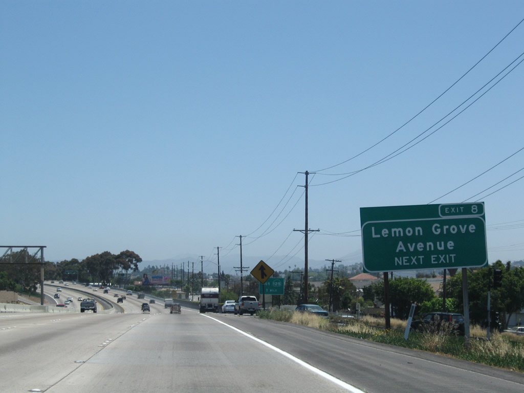
For the first time, California 94 leaves the city of San Diego and enters the city of Lemon Grove, the "Best Climate on Earth." Lemon Grove had a population of 24,918 people as of the 2000 Census. Founded in 1869, the city incorporated on July 1, 1977. Downtown Lemon Grove is located along Broadway, which is old California 94 south of the freeway. The best route to downtown from the freeway is via Exit 8, Lemon Grove Avenue south. Photo taken 08/22/04. |
|
The next three exits along California 94 east (Exit 6, College Avenue and Broadway; Exit 7, Massachusetts Avenue; and Exit 8, Lemon Grove Avenue) all serve the city of Lemon Grove. Photo taken 08/22/04. |
|
An advance guide sign for Exits 9A-B, California 125 north to La Mesa and south to Chula Vista is posted prior to the off-ramp for College Avenue. Photo taken 08/22/04. |
|
Eastbound California 94 reaches Exit 6, Broadway and College Avenue. Use College Avenue north to San Diego State University. From this point eastward, the city of La Mesa is located north of the freeway and the city of Lemon Grove is located south of the freeway. Broadway is old California 94, and it travels due east into downtown Lemon Grove. Photo taken 08/22/04. |
|
Now at the gore point for Exit 6, the bridge ahead carries traffic from westbound Broadway onto California 94 west. This connection is unusual since it brings a left entrance onto the westbound lanes of California 94. Photo taken 05/08/09. |
|
The next exit along eastbound California 94 (Martin Luther King, Jr. Freeway) is Exit 7, Massachusetts Avenue (0.25 mile). Taking Massachusetts Avenue north through La Mesa will lead to a connection with 70th Street via University Avenue, providing a through route to the 70th Street/Lake Murray Boulevard interchange with Interstate 8. Photo taken 08/22/04. |
|
Eastbound California 94 (Martin Luther King, Jr. Freeway) reaches Exit 7, Massachusetts Avenue. Many shopping facilities, including a Home Depot, are located south of the freeway on either Massachusetts Avenue or Broadway. Photo taken 08/22/04. |
|
The next exit along eastbound California 94 (Martin Luther King, Jr. Freeway) is Exit 8, Lemon Grove Avenue. Photo taken 05/08/09. |
|
California 125 is a major north-south corridor through the eastern suburbs of San Diego, and it meets California 94 at a massive interchange north of Spring Valley. Use California 125 south to the communities of Otay Ranch and Eastlake in the city of Chula Vista as well as unincorporated Bonita and the community of Otay Mesa in the city of San Diego. California 125 connects directly to California 905/Otay Mesa Freeway en route to the International Border crossing into Mexico. Photo taken 08/22/04. |
|
Eastbound California 94 (Martin Luther King, Jr. Freeway) meets Exit 8, Lemon Grove Avenue. Photo taken 08/22/04. |
|
Now passing under Lemon Grove Avenue, eastbound California 94 (Martin Luther King, Jr. Freeway) approaches the major interchange with California 125 (Exit 9A). This sign treats through traffic on California 94 as an exit, even though the next interchange is Exits 9A-B, California 125. Photo taken 08/22/04. |
|
The next interchange along California 94 (Martin Luther King, Jr. Freeway) east is Exits 9A-B-C, California 125 and Spring Street. Use Spring Street (Exit 9C) north into downtown La Mesa; use the California 94 "exit" to Spring Street. This sign was replaced in 2004 as the California 125 interchange was completed (see next photo for replacement). Note that the San Diego Trolley passes over California 94 at this point. Photo taken 07/14/02. |
|
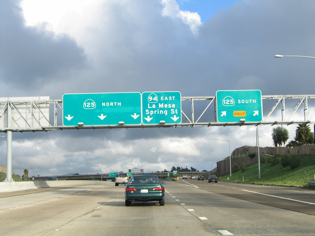
After the on-ramp from Lemon Grove Avenue, the freeway begins to split. The left three lanes connect to Exit 9B, California 125 (Helix Freeway) north to La Mesa, western El Cajon, and Santee. The right two lanes connect to California 94 east to Rancho San Diego, Jamul, and Campo. The right lane also connects to Exit 9A, California 125 (Sweetwater Freeway) south to eastern Chula Vista. Photo taken 02/21/05. |
|
Eastbound California 94 (Martin Luther King, Jr. Freeway) reaches Exit 9A, California 125 (Sweetwater Freeway) south to eastern Bonita and eastern Chula Vista. Stay right to continue east on California 94; stay left for California 125 north to La Mesa. Photo taken 02/21/05. |
|
|
Reaching Exit 9B, eastbound California 94 and northbound California 125 split. The 2002 photo shows the original sign for this location; the 2005 photo shows today's configuration. Photos taken 02/21/05 and 07/14/02. |
|
|
The ramp from California 94 (Martin Luther King, Jr. Freeway) east to Exit 9B, California 125 (Helix Freeway) north carries three lanes. The off-ramp for Exit 9B is a left exit. At this point, the Martin Luther King, Jr. Freeway designation comes to an end, but California 94 remains a freeway for another several miles east of here. Photos taken 08/22/04 and 02/21/05. |
|
The next exit along California 94 east is Exit 9C, Spring Street north to La Mesa. Through this interchange, California 94 skirts the southern boundary of the city of La Mesa, the "Jewel of the Hills." Home to 54,749 people as of the 2000 Census, La Mesa was founded in 1869 and incorporated on February 16, 1912. Additional lanes join California 94 from the right; these are incoming travel lanes from California 125 north. Photo taken 08/22/04. |
|
Eastbound California 94 meets Exit 9C, Spring Street north to La Mesa. This exit ramp is a collector distributor arrangement, so through traffic may exit here and still return to the freeway on the other side of the interchange. Photo taken 08/22/04. |
|
|
The next exit along eastbound California 94 is with Exit 10A, Bancroft Drive. An exit number sign was added here by 2008. Photos taken 05/08/09 and 08/22/04. |
|
Looking at the c/d lanes for Exit 9C, a sign is posted for the off-ramp to Spring Street and Broadway. Photo taken 08/22/04. |
|
This mileage sign provides the distance to the next three exits on California 94 east: Exit 10A, Bancroft Drive; Exit 10B, Kenwood Drive; and Exit 11, Sweetwater Springs Road. Photo taken 08/22/04. |
|
|
Eastbound California 94 reaches Exit 10A, Bancroft Drive. A new exit number sign was added in 2008. Photos taken 05/08/09 and 08/22/04. |
|
|
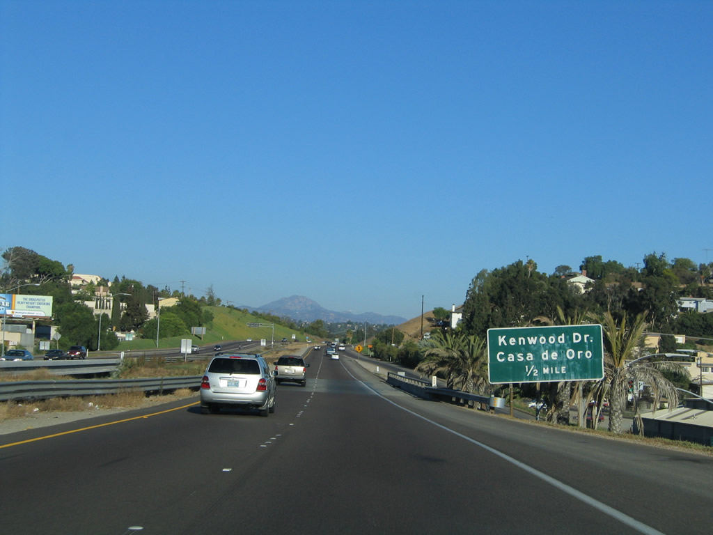
The next exit along California 94 east is Exit 10B, Kenwood Drive. A new exit number sign was added in 2008. Use Kenwood Drive northeast to Casa de Oro and west to northern Spring Valley. The unincorporated community of Spring Valley is generally located south of California 94, north and west of San Diego County S-17, and east of California 125. Spring Valley includes the neighborhood of La Presa, which is located at the California 125 and San Diego County S-17 interchange. The population of the community of Spring Valley (including La Presa) was 59,384 as of the 2000 Census. Photos taken 05/08/09 and 08/22/04. |
|
|
Eastbound California 94 reaches Exit 10B, Kenwood Drive. A new exit number sign was added in 2008. The Census Bureau considers the population of Casa de Oro and unincorporated Mount Helix to the north together as one Census Designated Place. The combined population of these two areas as of the 2000 Census was 18,874 people. Photos taken 05/08/09 and 08/22/04. |
|
The next exit along California 94 east is Exit 11, Sweetwater Springs Road (0.75 mile). Sweetwater Springs Road travels south through residential areas of Spring Valley and eventually connects to San Diego County S-17 (Jamacha Boulevard). Campo Road resumes at this interchange and travels west into the unincorporated community of Casa de Oro. Campo Road is the original path of California 94 through Casa de Oro. Photo taken 05/08/09. |
|
|
Eastbound California 94 reaches Exit 11, Sweetwater Springs Road. Photos taken 05/08/09 and 08/22/04. |
|
|
The next exit along California 94 east is Exit 12, Avocado Boulevard and Calavo Drive (0.75 mile). Use Avocado Boulevard north to downtown El Cajon. To the south, Calavo Drive leads into residential areas of unincorporated Spring Valley. Photos taken 05/08/09 and 08/22/04. |
|
Eastbound California 94 meets Exit 12, Avocado Boulevard and Calavo Drive. Photo taken 08/22/04. |
|
An end freeway (1/4 MILE) sign is posted along eastbound California 94 as the freeway passes under Avocado Boulevard and Calavo Drive. Photo taken 08/22/04. |
|
A signal ahead sign is posted after the on-ramp from Avocado Boulevard and Calavo Drive. The freeway ends ahead, and the speed limit reduces. Photo taken 08/22/04. |
|
The first traffic signal along California 94 east is with Via Mercado. True to its name, a shopping center (Rancho San Diego Village) is located just north of California 94. Photo taken 08/22/04. |
|
An end freeway sign is posted prior to the Via Mercado traffic signal. Photo taken 08/22/04. |
|
Eastbound California 94 (Campo Road) approaches San Diego County S-17 (Jamacha Boulevard) west to Spring Valley. Turning right (west) on County Route S-17 leads through southern Spring Valley and La Presa. Use San Diego County S-17 southwest to the continuation of California 54 west and California 125 (South Bay Expressway) south to Otay Ranch (in the city of Chula Vista) and the International Border Crossing at Otay Mesa. San Diego County S-17 is the approximate alignment of the missing link of California 54 as a freeway or expressway between Spring Valley and the California 94 junction in Rancho San Diego. Even though this sign indicates that County Route S-17 merges onto California 94 eastbound, there are no more County Route S-17 shields along the way. Photo taken 08/22/04. |
|
The next signalized intersection along California 94 (Campo Road) east is with California 54 (Jamacha Road) north to El Cajon. This sign advises through traffic on California 94 to prepare to turn right at the traffic signal. Photo taken 08/22/04. |
|
A second guide sign depicts the split between California 94 (Campo Road) east and California 54 (Jamacha Road) north (signed as "east"). This section of California 54 is not connected to the east-west freeway segment located between California 125 and Interstate 5 in Bonita, National City, San Diego, and Chula Vista. Photo taken 08/22/04. |
|
Eastbound California 94 (Campo Road) meets California 54 (Jamacha Road) at this traffic signal in Rancho San Diego. Photo taken 08/22/04. |
|
Looking east from the same traffic signal, a similar sign is posted on the mast arm of the traffic signal for California 94 and California 54, but the arrows point in different directions. Photo taken 05/08/09. |
|
With dominant Mt. San Miguel in the background, California 94 (Campo Road) travels east toward Jamul, Tecate, and Campo. Ahead is the crossing over the Sweetwater River; use the turnout to park and see the 1929 steel through truss bridge that used to serve as the primary crossing for California 94. Today the old bridge is in use for pedestrians and bicyclists. Photo taken 08/22/04. |
Page Updated July 1, 2011.