

California 99 South - Kern County
| California 99 south | |
|---|---|
 |
Exit 27 leads to the business loop for Bakersfield, which remains parted from the freeway all the way to Exit 11 (Union Avenue). The business route follows old U.S. 99, and U.S. 466 for the northern section. Photo taken 01/21/04. |
 |
The next exit along California 99 south is Exit 27, California 204 and California 99 Business (Golden State Avenue) in Bakersfield. Originally, California 99 was designated the Golden State Freeway. California 204 & California 99 Business head south as a freeway, changing into a surface street just north of downtown. The business route connects to California 178, making it a viable option to reach that highway rather than using Exit 26. Photo taken 01/21/04. |
 |
Mileage sign along southbound California 99 for the next three exits: Exit 26, California 178 east and California 58 west; Exit 25, California Avenue; and Exit 24, East California 58 (Stockdale Highway). Photo taken 01/21/04. |
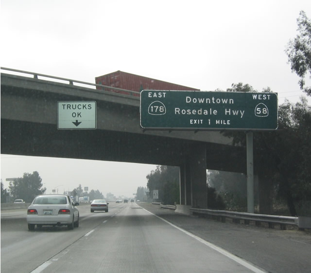 |
The next exit along southbound California 99 is Exit 26, California 58 west and California 178 east, one mile. Photo taken 01/21/04. |
 |
California 58 east merges with California 99 south between Exits 26 and 24, while westbound California 58 exits here at Exit 26. Photo taken 01/21/04. |
 |
Southbound California 99 meets Exit 26, California 178 east to Lake Isabella and California 58 west to Buttonwillow. Photo taken 01/21/04. |
 |
Now on the off-ramp from southbound California 99, this sign indicates that California 178 begins its westerly journey toward Lake Isabella here, while California 58 heads west toward Buttonwillow. Photo taken 01/21/04. |
 |
Southbound California 99 meets Exit 13, California 223 (Bear Mountain Road) east to Arvin. Photo taken by Pete Sison (05/26/03). |
 |
As California 99 south approaches Interstate 5, the tall Tehachapi Mountains and freeway ascent via the Grapevine come into view. Photo taken by Pete Sison (05/26/03). |
 |
California 166, the final exit along southbound, takes a path due west toward Maricopa, then follows the Cuyama River toward Santa Maria (near Vandenberg Air Force Base) and ultimately Guadalupe. Photo taken by Pete Sison (05/26/03). |
 |
Southbound California 99 meets Exit 3, California 166 west to Maricopa and Santa Maria. Photo taken by Pete Sison (05/26/03). |
 |
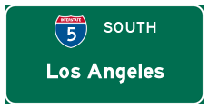
As southbound traffic approaches the southern end of California 99 and reach the merge with Interstate 5, auto traffic takes the main lanes, while trucks and busses should take the right lanes to allow slower and larger traffic to merge separately. The overpass shown here is the transition ramp carrying northbound Interstate 5. Photo taken by Pete Sison (05/26/03). |
 |
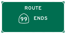
An end shield is posted California 99 south as it merges into Interstate 5 at Wheeler Ridge. Photo taken by Pete Sison (05/26/03). |

Page Updated August 5, 2004.
|
About Contact Glossary |
In The News Testimonials Interstate Guide |
Social Media:
 |
|
© 2000-23 AARoads.com | All Rights Reserved | Privacy Policy / Terms of Use
|
||