| Interstate 405 (San Diego Freeway) south |
|
Continuing south, Interstate 405 (San Diego Freeway) approaches Exit 40B, Redondo Beach Boulevard, immediately after the California 107 (Hawthorne Boulevard) interchange. Photo taken 05/30/04. |
|
To reach California 91 (Artesia Boulevard) west, use Exit 40B, Redondo Beach Boulevard west. Photo taken 05/30/04. |
|
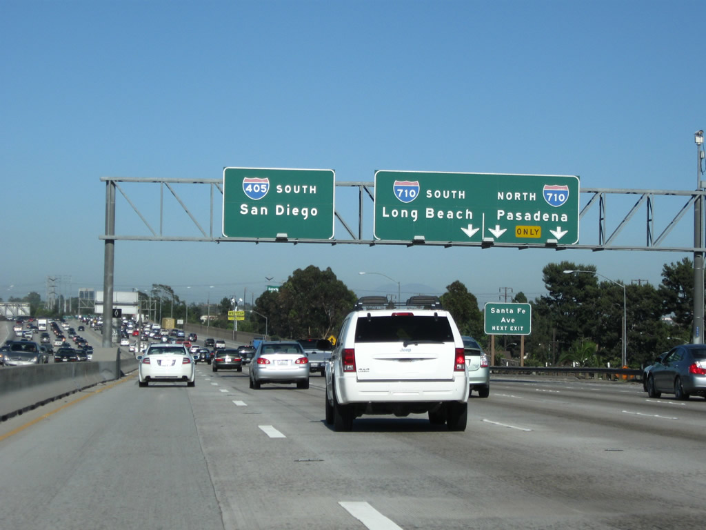
The next three exits along southbound Interstate 405 are Exit 40B, Redondo Beach Boulevard; Exit 40A, California 91 (Artesia Boulevard) east; and Exit 38B, California 213/Western Avenue. Photo taken 07/13/09. |
|
Use Exit 40B to reach Prairie Avenue south into Torrance and Alondra County Golf Course to the east. Redondo Beach Boulevard eastbound leads into Gardena and westbound leads into Redondo Beach, where it meets California 91 (Artesia Boulevard). Photo taken 05/30/04. |
|
Southbound Interstate 405 (San Diego Freeway) reaches Exit 40B, Redondo Beach Boulevard. At this point, Interstate 405 leaves the city of Lawndale and enters the city of Torrance ("The City with a Hometown Feel," population 137,946 as of 2000 Census, and incorporated on May 12, 1921). Photo taken 05/30/04. |
|
The next exit along southbound is Exit 40A, California 91 (Artesia Boulevard) east to Torrance and Gardena. East of Gardena (at Vermont Avenue), California 91 becomes a freeway as it progresses east toward Anaheim and then northeast toward Riverside. There is no direct access to westbound California 91 to Redondo Beach and Manhattan Beach from Interstate 405 south. Photo taken 05/30/04. |
|
This mileage sign provides the distance to the next three exits along southbound Interstate 405: Exit 40A, California 91 (Artesia Boulevard); Exit 39, Crenshaw Boulevard; and Exit 38B, California 213/Western Avenue. Photo taken 07/13/09. |
|
Southbound Interstate 405 (San Diego Freeway) reaches Exit 40A, California 91 (Artesia Boulevard) east. Despite the numerical designation, at no time did U.S. 91 extend this far west. Historically, U.S. 91 deviated from California 91 in Anaheim and took Center Street and Carson Street west to Lakewood Boulevard, Lakewood Boulevard south to former U.S. 101A (today's California 1 (Pacific Coast Highway)), and California 1 (PCH) northwest to Atlantic Avenue. At the PCH/Atlantic Avenue traffic signal, U.S. 91 arrived at its southern terminus, and U.S. 6 began its northerly journey toward downtown (and ultimately its easterly journey toward Massachusetts). U.S. 6 and U.S. 91 would meet again in Central Utah. Photo taken 05/30/04. |
|
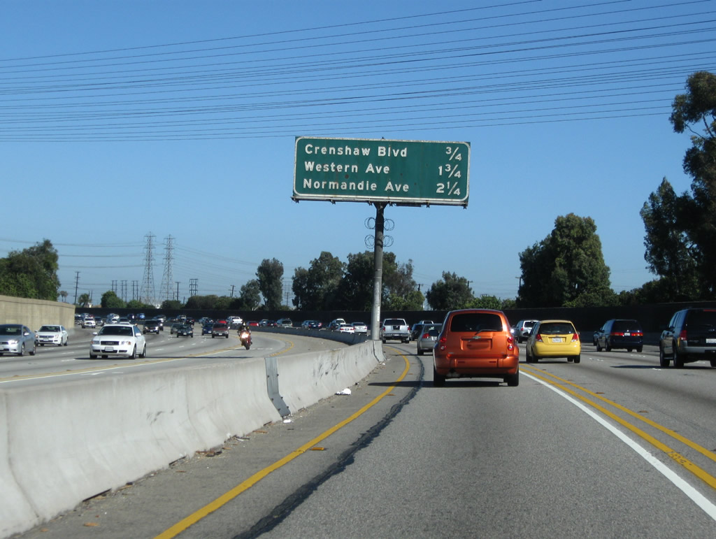
The next three exits along southbound are: Exit 39, Crenshaw Boulevard; Exit 38B, California 213/Western Avenue; and Exit 38A, Normandie Avenue. A set of Southern California Edison power lines cross the freeway at this point; additional lines cross the freeway ahead. Photo taken 07/13/09. |
|
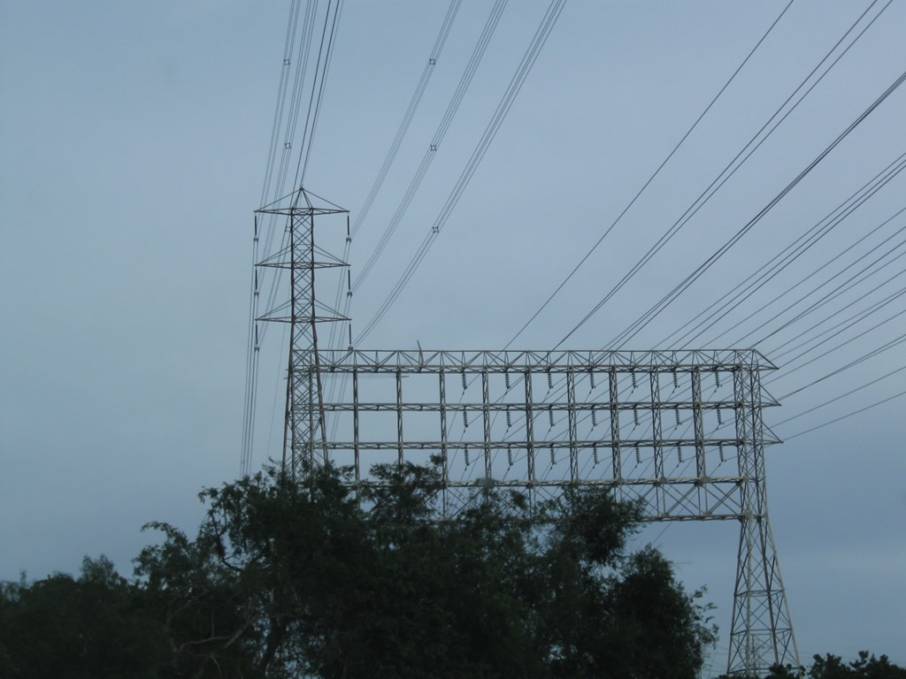
Passing overhead are a series of Southern California Edison power lines, including an unusual quadruple bundle 220kV double circuit tower above another unusual tower that can hold up to ten circuits of possibly 69kV lines. Photo taken 04/13/09. |
|
Use Crenshaw Boulevard south to Torrance. Crenshaw Boulevard passes by a couple of oil tanker farms and some industrial areas before entering the community areas along Torrance Boulevard, Carson Street, and Sepulveda Boulevard. Photo taken 05/30/04. |
|
|
Still more Southern California Edison power lines cross over Interstate 405, this time with two double-bundle 220kV double circuit towers along with the tower that can carry up to ten circuits of possibly 69kV lines. A wooden H-frame structure carries three other circuits, probably at 138kV. Photos taken 04/13/09. |
|
Southbound Interstate 405 (San Diego Freeway) reaches Exit 39, Crenshaw Boulevard south to Torrance and north to Gardena and Hawthorne. Photo taken 05/30/04. |
|
The next exit along southbound is Exit 38B, California 213/Western Avenue south to San Pedro and Rancho Palos Verdes. California 213 is a fairly short state route that extends from Interstate 405 south to San Pedro. Photo taken 05/30/04. |
|
The next three exits along southbound are Exit 38B, Western Avenue/California 213 south; Exit 38A, Normandie Avenue; and Exit 37B, Vermont Avenue. Each of these exit ramps were designed to terminate on parallel 190th Street. By turning left at the end of each ramp, eastbound 190th Street in turn connects to the streets named on this sign. Photo taken 05/30/04. |
|
Southbound Interstate 405 (San Diego Freeway) reaches Exit 38B, California 213/Western Avenue south and Western Avenue north. Although not signed, Interstate 405 departs Torrance and reenters the city of Los Angeles briefly (between California 213 and Vermont Avenue, just prior to the Interstate 110 (Harbor Freeway) interchange. At Interstate 110, Interstate 405 will again leave Los Angeles and enter the city of Carson, continuing its tradition of passing through many cities along its busy path. Photo taken 05/30/04. |
|
This mileage sign provides the distance to the next three exits along southbound Interstate 405 (San Diego Freeway): Exit 38A, Normandie Avenue; Exit 37B, Vermont Avenue; and Exit 37A, Interstate 110 (Harbor Freeway). Photo taken 04/13/09. |
|
Southbound Interstate 405 (San Diego Freeway) reaches Exit 38A, Normandie Avenue. The next two exits are Exit 37B, Vermont Avenue and Exit 37A, Interstate 110 (Harbor Freeway). Photo taken 04/13/09. |
|
To the Port of Los Angeles, follow Interstate 110 (Harbor Freeway) south. Photo taken 04/13/09. |
|
This mileage sign provides the distance to the next three exits along southbound Interstate 405 (San Diego Freeway): Exit 37B, Vermont Avenue; Exit 37A, Interstate 110 (Harbor Freeway); and Exit 35, Avalon Boulevard. Photo taken 04/13/09. |
|
Vermont Avenue is a major north-south arterial that generally parallels Interstate 110 on the west side of the freeway. Photo taken 04/13/09. |
|
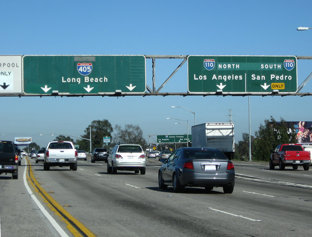
Southbound Interstate 405 (San Diego Freeway) reaches Exit 37B, Vermont Avenue. The overhead signs provide lane allocations for the connection to Exit 37A, Interstate 110 (Harbor Freeway). The Harbor Freeway, which was constructed as U.S. 6 and California 11 in the late 1950s and early 1960s, became designated exclusively as California 11 after U.S. 6 was decommissioned through much of California in 1964. In 1981, signs for California 11 were replaced with signs for Interstate 110 along the Harbor Freeway south of Interstate 10 (north of there, California 11 became California 110). In this bank of signs, the California 11 shield originally on the porcelain enamel guide sign is covered up with an Interstate 110 shield. Photo taken 07/13/09. |
|
Immediately thereafter, southbound Interstate 405 (San Diego Freeway) reaches Exit 37A, Interstate 110 (Harbor Freeway). Interstate 110 travels north to downtown Los Angeles as the Harbor Freeway, then changes into the Arroyo Seco Parkway (Pasadena Freeway) upon passing through the Four-Level Interchange (U.S. 101 and California 110). California 110 travels northeast from the Four-Level, ending near downtown Pasadena after passing through that historic corridor. To the south, Interstate 110 connects to California 47 east to the commercial Ports of Los Angeles and Long Beach and connects to Gaffey Street en route to San Pedro, a community of Los Angeles. A busy north-south freeway, Interstate 110 includes the Transitway for buses and high occupancy vehicles leading north toward downtown Los Angeles. Photo taken 07/13/09. |
|
Looking at the off-ramp to Interstate 110, the right lanes connect to Interstate 110 south to the Port of Los Angeles and San Pedro, while the left lane connects to Interstate 110 north to downtown Los Angeles. At this point, Interstate 405 leaves the city of Los Angeles and enters the city of Carson ("Future Unlimited," population 89,730 as of the 2000 Census, incorporated on February 20, 1968). Photo taken 07/13/09. |
|
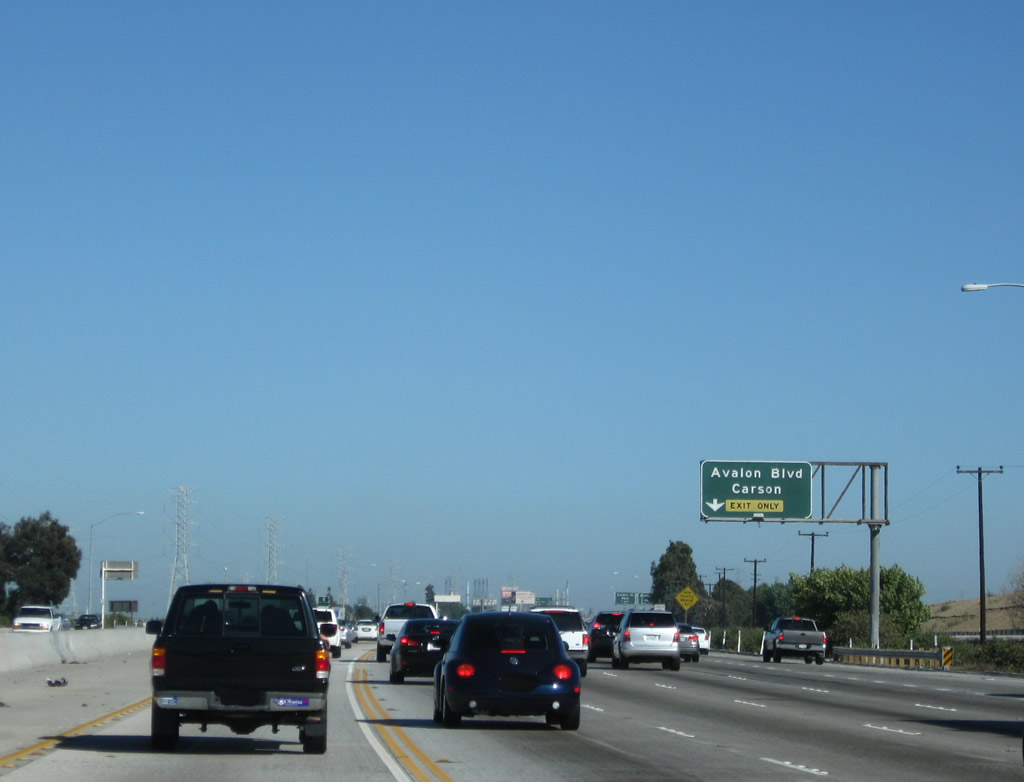
This mileage sign provides the distance to the next three exits along southbound Interstate 405 (San Diego Freeway): Exit 35, Avalon Boulevard; Exit 34, Carson Street; and Exit 33B, Wilmington Avenue. Between Interstate 110 and California 22, Interstate 405 takes a mostly east-west trajectory, so "southbound" traffic is actually heading nearly due east or southeast until we reach the eastern California 22 interchange. Photo taken 07/13/09. |
|
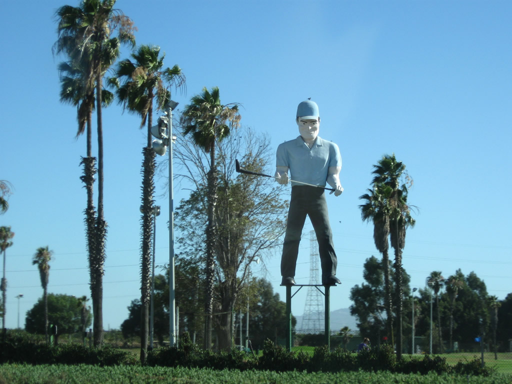
Feel like playing golf? It probably beats fighting the traffic on Interstate 405. The statue is inviting golfers to play at Dominguez Hills Golf Course. The course is located just southeast of the Interstate 405-110 interchange. Photo taken 07/13/09. |
|
Everywhere you look is ... a California 1 route marker shield? This sign is mounted on a bank billboard for a summer 2009 advertising campaign. California 1 is not far from here; in fact, Interstate 405 generally parallels California 1 between Santa Monica and Irvine. California 1, which follows the Pacific Coast Highway through Long Beach, is only a few miles south of here, running parallel to Interstate 405. Photo taken 07/13/09. |
|
After a weigh station (Exit 36), the next exit along Interstate 405 (San Diego Freeway) is Exit 35, Avalon Boulevard. This interchange is the first of four to serve the city of Carson: Exit 35, Avalon Boulevard; Exit 34, Carson Street; Exit 33B, Wilmington Avenue; and Exit 33A, California 47 (Alameda Street). Photo taken 07/13/09. |
|
Los Angeles Department of Water and Power lines cross over Interstate 405, carrying electricity from generating facilities near the port onto the grid. Photo taken 04/13/09. |
|
Southbound Interstate 405 (San Diego Freeway) reaches Exit 35, Avalon Boulevard. The next exit along Interstate 405 south is Exit 34, Carson Street. Photo taken 07/13/09. |
|
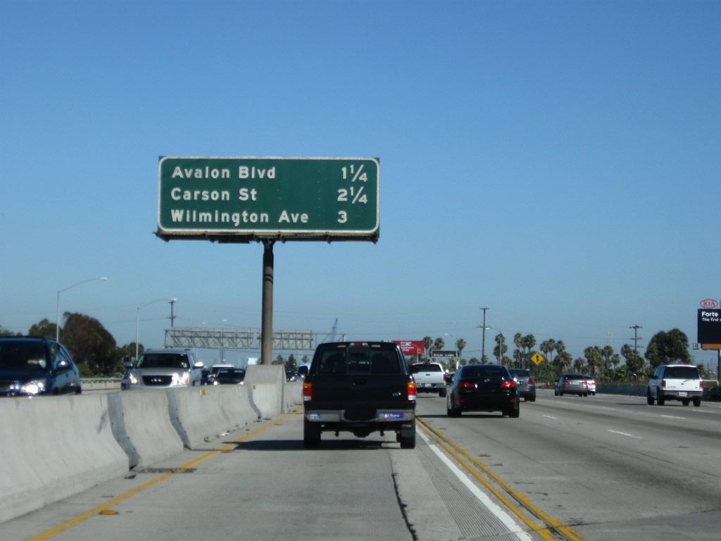
This mileage sign provides the distance to the next three exits along southbound Interstate 405 (San Diego Freeway): Exit 34, Carson Street; Exit 33B, Wilmington Avenue; and Exit 33A, California 47 (Alameda Street). Photo taken 04/13/09. |
|
Southbound Interstate 405 (San Diego Freeway) meets Exit 34, Carson Street. Photo taken 07/13/09. |
|
|
This mileage sign provides the distance to the next three exits along southbound Interstate 405 (San Diego Freeway): Exit 33B, Wilmington Avenue; Exit 33A, California 47 (Alameda Street); and Exit 32D, Santa Fe Avenue. Photos taken 04/13/09 and 07/13/09. |
|
Southbound Interstate 405 (San Diego Freeway) reaches Exit 33B, Wilmington Avenue. Photo taken 04/13/09. |
|
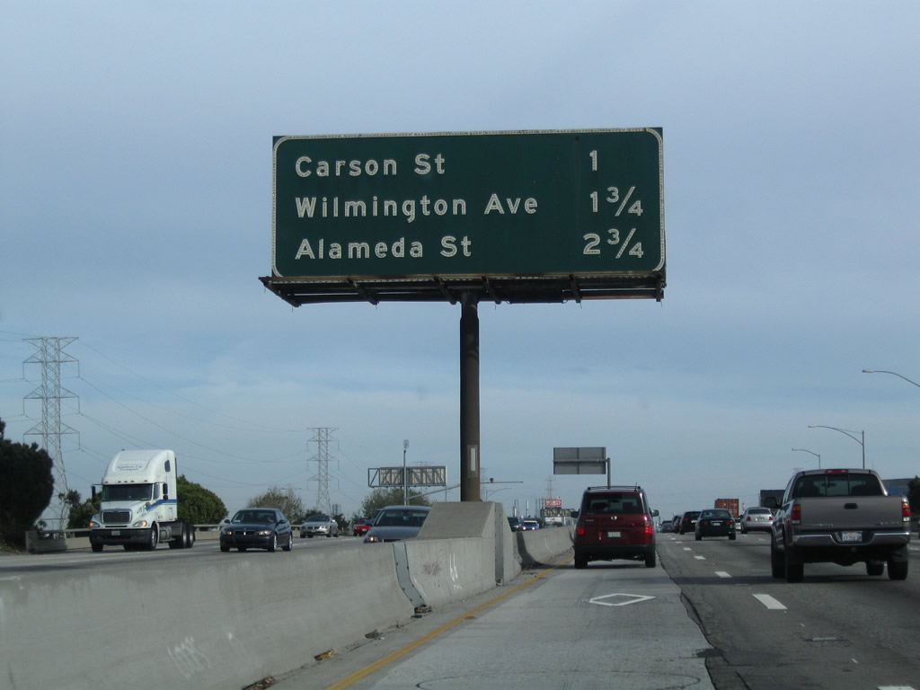
This mileage sign provides the distance to the next three exits along southbound Interstate 405 (San Diego Freeway): Exit 33A, California 47 (Alameda Street); Exit 32D, Santa Fe Avenue; and Exits 32C-B, Interstate 710 north to Pasadena and south to Long Beach. Photo taken 04/13/09. |
|
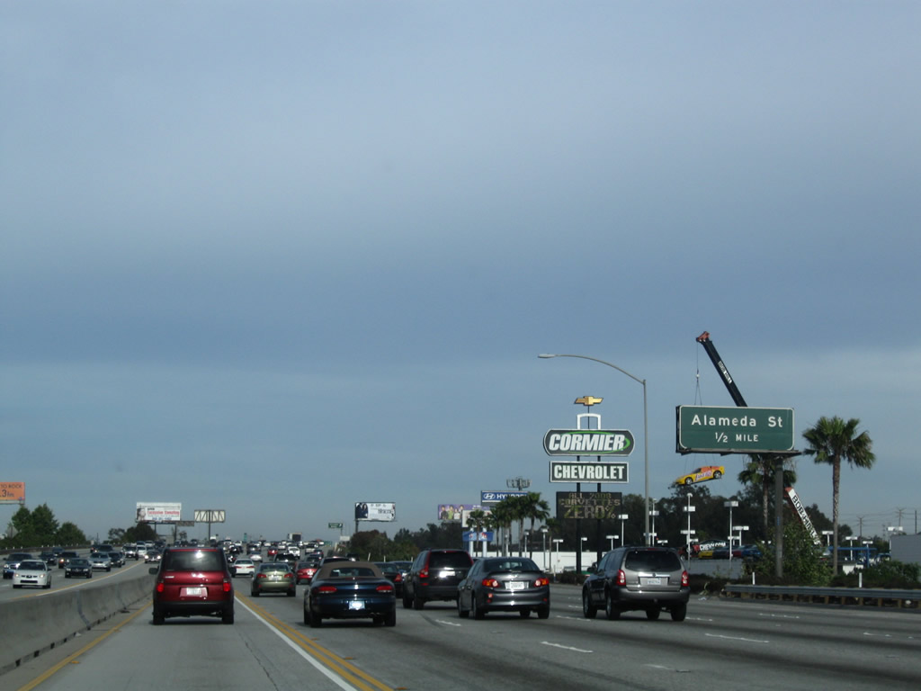
California 47 follows Alameda Street along the Alameda Corridor, which is an approximately 20-mile long freight rail corridor owned by the Alameda Corridor Transportation Authority and part of Congressional High Priority Corridor 22. As part of the project to upgrade the freight rail corridor by removing at-grade railroad crossings and creating the Mid-Corridor Trench (a ten-mile section of railroad with triple track below grade opened on April 15, 2002), nearby Alameda Street was upgraded to expressway characteristics between Henry Ford Avenue and California 91. This segment of expressway was designated and signed as part of California 47 in 2002, but it is not (as of August 2010) state maintained. Currently, the signs for Alameda Street at the Interstate 405 and California 91 interchanges do not reference the California 47 designation. On Alameda Street itself, reassurance markers for California 47 are posted as far north as the California 91 freeway. Photo taken 04/13/09. |
|
Southbound Interstate 405 (San Diego Freeway) reaches Exit 33A, California 47 (Alameda Street) north to Carson and south to the Ports of Long Beach and Los Angeles. A proposed connection between Alameda Street and California 103 (Terminal Island Freeway) (called the Port Access Expressway) is planned to replace the temporary connection via Henry Ford Avenue, but that connection is not in place. Thus, California 47 may not be the fastest way to the port. Photo taken 04/13/09. |
|
For access to the next six exits -- Exit 32D, Santa Fe Avenue; Exits 32C-B, Interstate 710 (Long Beach Freeway); Exit 32A, Pacific Avenue; Exit 30B, Wardlow Road and Long Beach Blvd; and Exit 30A, Atlantic Avenue (former California 15) -- carpools should merge right as there is no direct connection. Photo taken 04/13/09. |
|
Stay right for the next off-ramp, which connects Interstate 405 south to Exit 32D, Santa Fe Avenue and Exit 32C, Interstate 710 north to East Los Angeles. The second off-ramp connects to Exit 32B, Interstate 710 (Long Beach Freeway) south to Long Beach. Photo taken 07/13/09. |
|
Southbound Interstate 405 (San Diego Freeway) reaches Exit 32D, Santa Fe Avenue and Exit 32C, Interstate 710 north to East Los Angeles. A single off-ramp links Interstate 405 south to both Exit 32D and 32C. Photo taken 07/13/09. |
|
|
This view looks from the mainline of Interstate 405 south to the off-ramp that links to Exit 32D, Santa Fe Avenue and Exit 32C, Interstate 710 north to East Los Angeles (and someday Pasadena). The off-ramp first connects to Santa Fe Avenue, and the second ramp links to Interstate 710 north. Photos taken 07/13/09 and 04/13/09. |
|
This interchange sequence sign provides the distance to three of the next four exits (omitting the next exit, which links Interstate 405 (San Diego Freeway) south to Interstate 710 (Long Beach Freeway) south (Exit 32B). The next three exits are: Exit 32A, Pacific Avenue; Exit 30B, Wardlow Road and Long Beach Blvd; and Exit 30A, Atlantic Avenue (former California 15). Photo taken 04/13/09. |
|
Southbound Interstate 405 (San Diego Freeway) reaches Exit 32B, Interstate 710 (Long Beach Freeway) south to downtown Long Beach, the Queen Mary, Aquarium of the Pacific, and the Port of Long Beach. Just prior to the interchange with Interstate 710, southbound Interstate 405 leaves Carson and enters the city of Long Beach. Photo taken 04/13/09. |
|
|
Three sets of Southern California Edison powerlines, which parallel Interstate 710 and the Los Angeles River, cross over Interstate 405. The two taller towers carry two circuits each and are likely charged at 220kV. The shorter tower carries six circuits at a voltage likely to be around 69kV. Photos taken 04/13/09. |
|
The next exit along Interstate 405 (San Diego Freeway) south is Exit 32A, Pacific Avenue (0.50 mile). Photo taken 04/13/09. |
|
Southbound Interstate 405 (San Diego Freeway) reaches Exit 32A, Pacific Avenue within the city of Long Beach. For the rest of its journey through Los Angeles County, Interstate 405 will remain within the city of Long Beach (except a brief foray into the city of Signal Hill between Exits 30A and 29C). The city limits/county line is located near the Interstate 605 interchange, at the San Gabriel River bridge. Photo taken 04/13/09. |
|
This mileage sign along Interstate 405 south provides the distance to the next three exits: Exit 30B, Long Beach Boulevard; Exit 30A, Atlantic Avenue; and Exit 29C, Orange Avenue. Through Long Beach, Interstate 405 continues to angle in a more easterly direction rather than south, partially because the coastline of the Pacific Ocean also cuts inland. Both Interstate 405 (San Diego Freeway) and California 1 (Pacific Coast Highway) travel primarily in an east-west direction. Photos taken 04/13/09 and 05/30/04. |
|
|
The next reassurance shield is actually a guide sign stating "South Interstate 405, San Diego Freeway." A few of these signs are found in varying intervals along the freeway. Photo taken 07/13/09. |
|
|
Southbound Interstate 405 (San Diego Freeway) reaches Exit 30B, Long Beach Boulevard. The next exit is Exit 30A, Atlantic Avenue, one-half mile. Photos taken 04/13/09 and 05/30/04. |
|
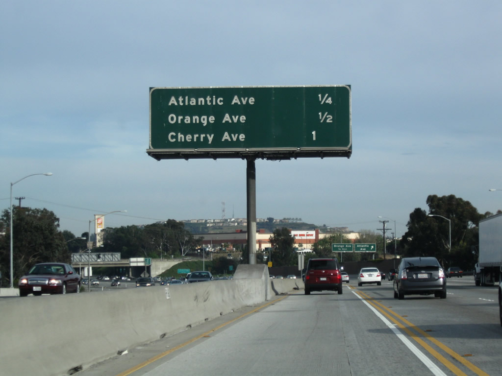
This mileage sign along southbound Interstate 405 (San Diego Freeway) provides the distance to the next four exits: Exit 30A, Atlantic Avenue (former California 15); Exit 29C, Orange Avenue; and Exits 29B-A, Cherry Avenue. After Exit 30A, Interstate 405 leaves Long Beach briefly and enters the city of Signal Hill. Photo taken 04/13/09. |
|
Exit 30A leaves I-405 south for Atlantic Avenue. Atlantic Avenue is the former alignment of California 15. The state route extended south to California (Pacific Coast Highway), where U.S. 6 and U.S. 91 ended until 1964. Photo taken 09/28/08. |
|
This mileage sign along southbound Interstate 405 (San Diego Freeway) provides the distance to the next four exits: Exit 29C, Orange Avenue; Exits 29B-A, Cherry Avenue; and Exit 27, California 19 (Lakewood Boulevard). The California 19 shield was removed from this sign, perhaps owing to its decommissioning along portions of Lakewood Boulevard in Long Beach. Even after decommissioning however, the remaining segments of California 19 are still signed to allow for route continuity. Photo taken 09/28/08. |
|
Southbound Interstate 405 (San Diego Freeway) reaches Exit 29C, Orange Avenue. Interstate 405 leaves Signal Hill and again enters Long Beach. Photo taken 09/28/08. |
|
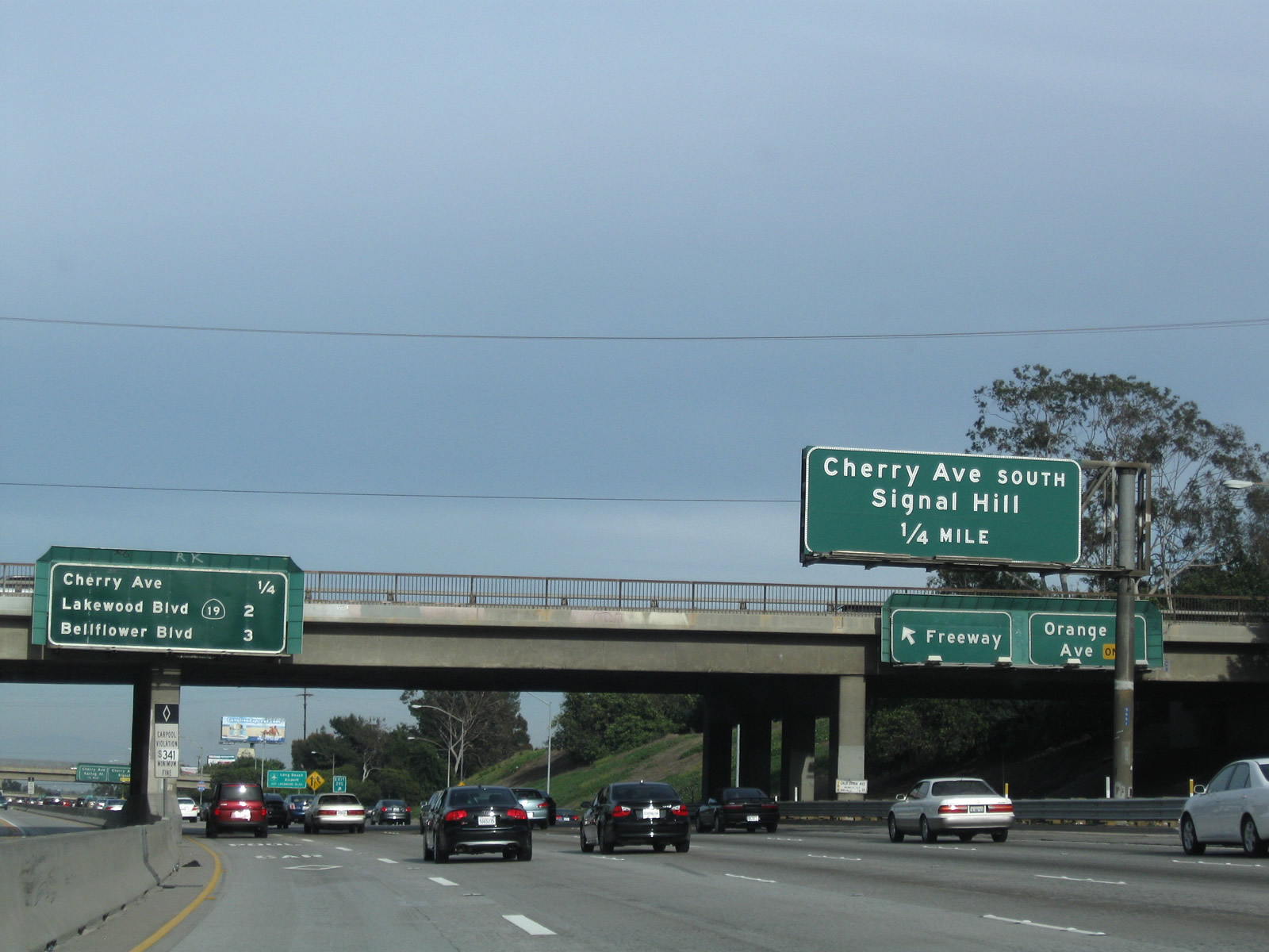
The next exit along Interstate 405 (San Diego Freeway) south is Exit 29B, Cherry Avenue south. Southbound Cherry Avenue leads into the city of Signal Hill. Note the collector distributor lanes for Orange Avenue to the right of the main lanes. Photo taken 04/13/09. |
|
This interchange sequence sign along southbound Interstate 405 is posted on the Orange Avenue overpass. The next three exits are: Exit 29B, Cherry Avenue south; Exit 29A, Cherry Avenue north; Exit 27, California 19 (Lakewood Boulevard); and Exit 26, Bellflower Boulevard. Photo taken 07/13/09. |
|
Use Exit 27 (Lakewood Boulevard) to Long Beach Airport. The dual freeway/collector distributor lane arrangement continues through this cluster of on/off ramps. Photo taken 04/13/09. |
|
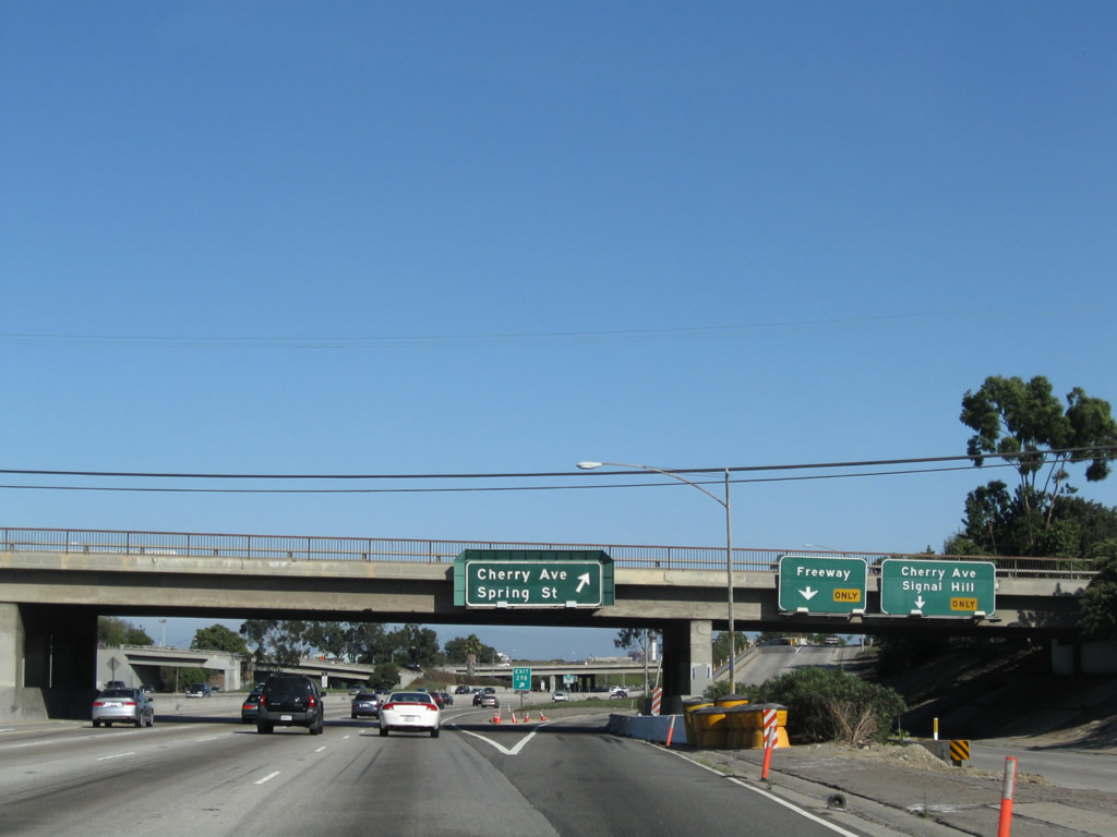
Southbound Interstate 405 (San Diego Freeway) reaches Exit 29B, Cherry Avenue, which travels south to the enclave of Signal Hill. This city, which is entirely surrounded by the city of Long Beach, was incorporated on April 22, 1924, had a population of 9,333 as of the 2000 Census. Photo taken 09/28/08. |
|
Immediately thereafter, southbound Interstate 405 (San Diego Freeway) reaches Exit 29A, Northbound Cherry Avenue to northern Long Beach, Lakewood, and Paramount. This exit also connects to east-west Spring Street, which passes by the southern boundary of the Long Beach Airport. Photo taken 09/28/08. |
|
This mileage sign provides the distance to the next three exits along southbound Interstate 405: Exit 27, California 19 (Lakewood Boulevard); Exit 26, Bellflower Boulevard; and Exit 25, Palo Verde Avenue. Photo taken 04/13/09. |
|
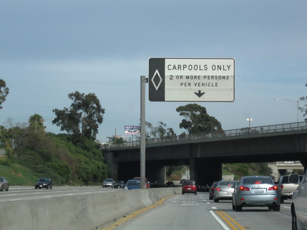
A carpool entrance/exit point is located after the Cherry Avenue interchange. Photo taken 04/13/09. |
|
Interstate 405 ducks to the southeast, allowing the freeway to avoid the southern edge of Long Beach Airport. This means Interstate 405 passes under Spring Street, an east-west arterial street that has paralleled Interstate 405 through Signal Hill. Photo taken 04/13/09. |
|
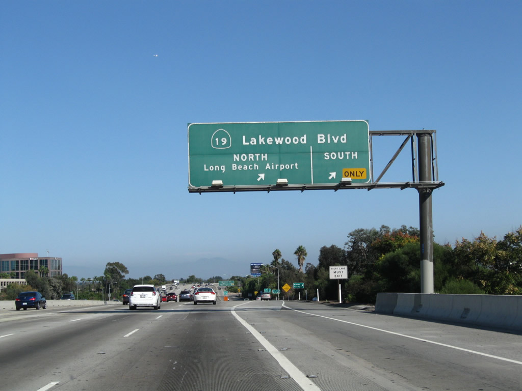
The next exit along Interstate 405 south is Exit 27, California 19, Lakewood Boulevard. California 19 is a divided, multi-lane highway from its inception at the Long Beach traffic circle with California 1 (Pacific Coast Highway) north to Interstate 210 in eastern Pasadena. Photo taken 07/13/09. |
|
Southbound Interstate 405 (San Diego Freeway) reaches Exit 27, California 19 (Lakewood Boulevard). This exit provides the most direct route to Long Beach Airport (via north California 19). Photo taken 09/28/08. |
|
This view looks at the collector distributor lanes for the California 19 (Lakewood Boulevard) interchange. Photo taken 09/28/08. |
|
This mileage sign along southbound Interstate 405 (San Diego Freeway) provides the distance to Exit 26, Bellflower Boulevard; Exit 25, Palo Verde Avenue; and Exit 24B, Studebaker Road. Photo taken 04/13/09. |
|
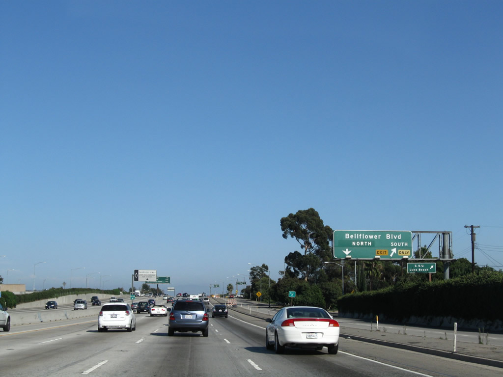
The right lane of Interstate 405 (San Diego Freeway) south becomes exit only for Exit 26, Bellflower Boulevard. Photo taken 09/28/08. |
|
An Interstate 405 south reassurance shield is posted after the on-ramp from California 19. A Jet Blue airplane was making its final descent into Long Beach Airport. Photo taken 07/13/09. |
|
Bellflower Boulevard (Exit 26) exits southbound Interstate 405 here, and it provides access to California State University-Long Beach. Apparently it is okay to place a tab above this sign, which indicates that through traffic may use this exit (some other exits only serve residential areas and do not provide a direct route into downtown Long Beach). The reason why the concept of a tab above a sign such as this one is worth mentioning is because the state dislikes placing tabs such as these for the ongoing exit numbering program. However, a few exceptions to the prohibition of tabs above signs occur, and this is one of those places. Photo taken 09/28/08. |
|
View of the collector distributor lanes associated with Exit 26, Bellflower Boulevard as seen from the mainlanes of southbound Interstate 405 in Long Beach. Photo taken 09/28/08. |
|
This mileage sign along southbound Interstate 405 (San Diego Freeway) provides the distance to the next three exits: Exit 25, Palo Verde Avenue; Exit 24B, Studebaker Road; and Exit 24A, Interstate 605 (San Gabriel River Freeway) north. Photo taken 04/13/09. |
|
Southbound Interstate 405 (San Diego Freeway) reaches Exit 25, Palo Verde Avenue. Photo taken 09/28/08. |
|
This mileage sign along southbound Interstate 405 (San Diego Freeway) provides the distance to the next three exits: Exit 24B, Studebaker Road; Exit 24A, Interstate 605 (San Gabriel River Freeway) north to Norwalk and Downey; and Exit 23, California 22/7th Street west to Long Beach. Photo taken 04/13/09. |
|
Although the next exit is for Exit 24B (Studebaker Road), this sign along southbound warns motorists of the upcoming major freeway-to-freeway interchange with Interstate 605 (Exit 24A). Interstate 605 and Interstate 710 provide parallel routes from Long Beach north to Interstate 10 east of downtown Los Angeles without using Interstate 5 or passing through downtown. Since Interstate 710 serves the Ports of Long Beach and Los Angeles, it tends to carry a bit more commercial traffic than Interstate 605. Photo taken 07/13/09. |
|
The next exit along Interstate 405 (San Diego Freeway) south is Exit 24B, Studebaker Road. Studebaker Road leads south into Long Beach, connecting with California 22/7th Street and California 1 (Pacific Coast Highway). Photo taken 09/28/08. |
|
Southbound Interstate 405 (San Diego Freeway) reaches Exit 24B, Studebaker Road. For some reason, there is an exit number pasted onto the Interstate 605 sign (Exit 24A) but not the Studebaker Road sign. Note that westbound California 22 (Exit 23) is mentioned on this sign, unlike the previous sign featuring Interstate 605. Photo taken 09/28/08. |
|
This mileage sign along southbound Interstate 405 (San Diego Freeway) provides the distance to the next three exits: Exit 24A, Interstate 605 (San Gabriel River Freeway); Exit 23, California 22/7th Street; and Exit 22, Seal Beach Boulevard and Los Alamitos Boulevard. Photo taken 04/13/09. |
|
Southbound Interstate 405 reaches Exit 24A, Interstate 605/San Gabriel Freeway north to Duarte. Interstate 605 passes through a variety of suburbs of Los Angeles, then skirts the eastern edge of the Los Angeles Basin en route to El Monte and Duarte, terminating at Interstate 210 and Historic U.S. 66. The next exit on southbound Interstate 405 is Exit 23, California 22 west. Note that eastbound California 22 merges onto southbound Interstate 405. At this interchange, Interstate 405 leaves Los Angeles County and enters Orange County. Photo taken 09/28/08. |
|
Southbound Interstate 405 (San Diego Freeway) reaches Exit 23, California 22 (Seventh Street) west to Long Beach. At this point, Interstate 405 will leave the city of Long Beach and Los Angeles County and enter the city of Seal Beach and Orange County. California 22 is a major east-west corridor across northern and central Orange County. To the west of Interstate 405, California 22 travels west along 7th Street toward California 1 in Long Beach. California 22 west starts as a freeway but quickly reverts to a surface street (7th Street) immediately upon entering Long Beach. State maintenance of Seventh Street ends at its junction with California 1 (Pacific Coast Highway), and California 22 comes to its end at that intersection. Photo taken 09/28/08. |
|
This interchange involves a variety of ramps and bridges that interconnect Interstate 405, Interstate 605, California 22, and Studebaker Road (as well as other local connections). Spread out over nearly a mile, this is a massive interchange complex. The southern terminus of Interstate 605 passes over Interstate 405 at this overpass, with its own connections to California 22 (Seventh Street). Around this point, Interstate 405 leaves Los Angeles County and enters Orange County. Photo taken 09/28/08. |
Page Updated November 13, 2010.