|
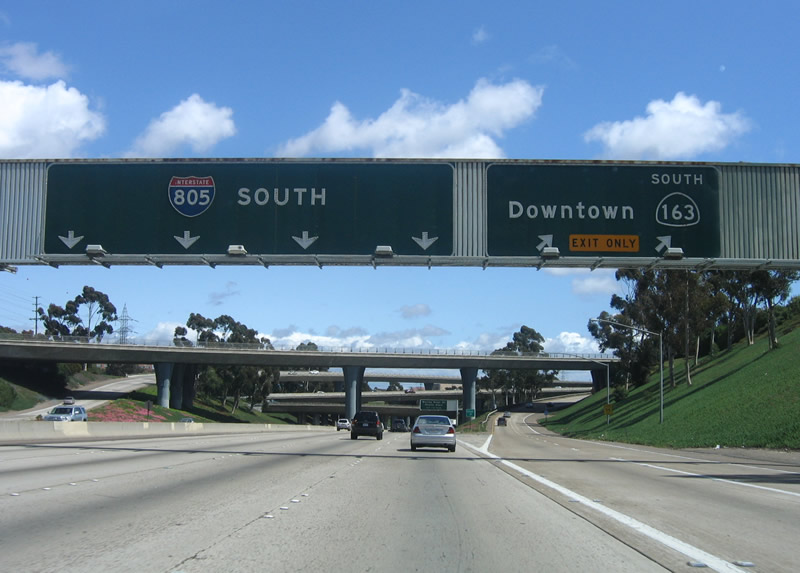
| Interstate 5 and Interstate 805 split here, with the left four lanes transitioning onto southbound Interstate 805 (Jacob Dekema Freeway) and the right four lanes staying on Interstate 5 southbound. 04/18/06 |
|
| Immediately after the left exit from southbound Interstate 5, southbound Interstate 805 begins its southerly journey along the Jacob Dekema Freeway. The first exit along southbound Interstate 805/Dekema Freeway is Exit 27, Mira Mesa Boulevard east and Sorrento Valley Road west. Note the construction of a new truck bypass for the Interstate 5/805 split to the right (southwest) of the freeway. Northbound Interstate 5 passes over Interstate 805 in this photo. 07/18/04, 04/23/06 |
|
| The first two exits along southbound Interstate 805/Dekema Freeway are Exit 27, Mira Mesa Boulevard/Sorrento Valley Road and Exit 25, Miramar Road/La Jolla Village Drive. Interstate 805 provides a shorter, more direct route to the International Border with Mexico (Tijuana, Ensenada, and Baja California) than Interstate 5, which passes through downtown San Diego and takes a less direct route to the border. Only a few signs (all south of Interstate 8) even mention Mexican cities as destinations; the overhead signs all say "Interstate 805 South" without control cities. Interstate 805 remains entirely within San Diego, with the exception of the sections in National City between 43rd Street and SR 54/South Bay Freeway and in Chula Vista between SR 54 and Otay Valley Road. The newer sign is reflective, while the older one is button copy and has since been replaced. 07/18/04, 04/18/06 |
|
| The left three lanes carry Interstate 805 south, while the two right lanes become exit only for Exit 27, Mira Mesa Boulevard and Sorrento Valley Road. Exit 27 is the primary entry point to Sorrento Valley, which contains a variety of industrial and business parks. Traffic delays are common in both directions of Interstate 805 during morning and afternoon commutes due to the sheer volume of people commuting to work in Sorrento Valley. 04/18/06 |
|
| Southbound Interstate 805/Dekema Freeway reaches Exit 27, Mira Mesa Boulevard east and Sorrento Valley Road west. Mira Mesa Boulevard travels east through Sorrento Valley then into Mira Mesa. It connects to Interstate 15 near Scripps Ranch. As for Sorrento Valley Road, it turns northwest to parallel the railroad tracks and Interstate 805 back to Interstate 5 and then north to Carmel Mountain Road near Torrey Hills. 04/18/06 |
|
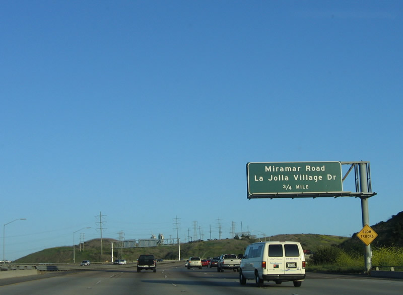
| The next two exits along southbound Interstate 805 are Exit 25, Miramar Road east and La Jolla Village Drive west and Exit 24, Governor Drive. Both exits serve the University City community of San Diego as well as Mira Mesa to the east. 04/18/06 |
|
| The next interchange along southbound Interstate 805 is Exit 25, Miramar Road east and La Jolla Village Drive west, three-quarters of a mile. 04/18/06 |
|
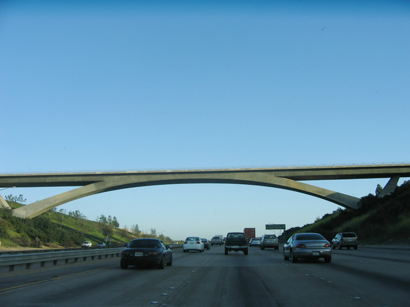
| An arch bridge carries Eastgate Drive over Interstate 805 as the freeway approaches the La Jolla Village Drive/Miramar Road interchange (Exit 25). Use Exit 25 (Miramar Road east) for Nobel Drive. 07/18/04, 04/18/06 |
|
| Southbound Interstate 805/Dekema Freeway reaches Exit 25, Miramar Road east to Mira Mesa and La Jolla Village Drive west to the University Towne Center (UTC), University City, University of California at San Diego (UCSD), and La Jolla. This interchange is a modified cloverleaf. 04/23/06 |
|
| The next exit along southbound Interstate 805/Dekema Freeway is Exit 24, Governor Drive, 1.25 miles. There is no access from southbound Interstate 805 to Nobel Drive (despite the Cal-Nexus site, which indicates that Exit 25A is a ramp to Nobel Drive - no such ramp exists). 04/18/06 |
|
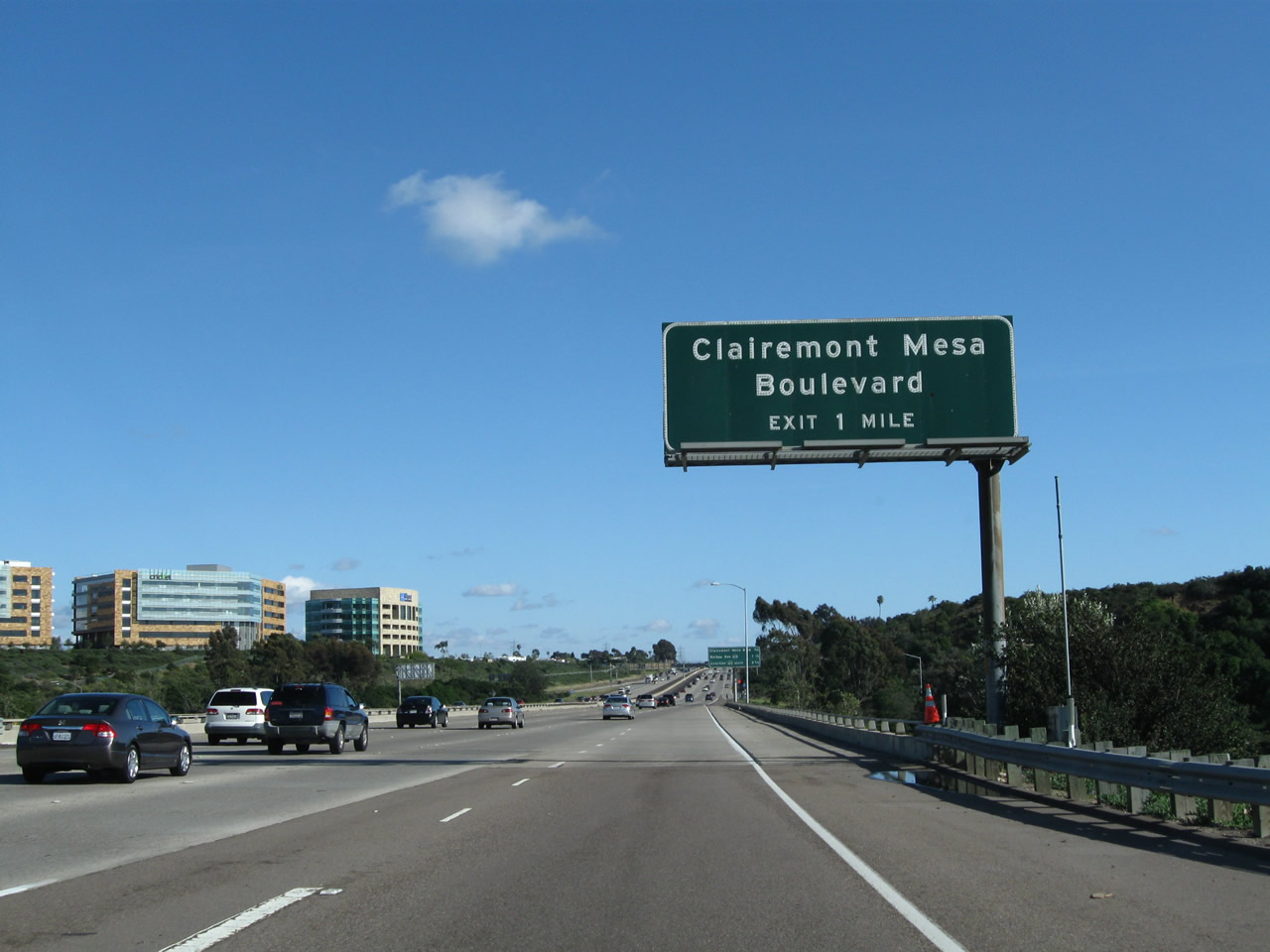
| The next three exits along southbound Interstate 805/Dekema Freeway are Exit 24, Governor Drive; Exit 23, SR 52; and Exit 22, Clairemont Mesa Boulevard. 04/18/06 |
|
| The left four lanes continue straight ahead on southbound Interstate 805/Dekema Freeway, while the right lane prepares to exit only to Exit 24, Governor Drive. 04/18/06 |
|
| Southbound Interstate 805/Dekema Freeway reaches Exit 24, Governor Drive. Governor Drive heads east into University City/La Jolla. It does not extend east, as Interstate 805 serves as the western boundary to Miramar Marine Corps Air Station (MCAS). The MCAS is undeveloped near the freeway, with the exception of a city of San Diego water treatment plant. 04/18/06 |
|
| The next exit along southbound is Exit 23, SR 52. This freeway extends west to La Jolla, with a direct connection to La Jolla Parkway west into downtown La Jolla. Looking east, SR 52 skirts the southern edge of the Miramar MCAS, and serves the San Diego Landfill. The freeway then continues east to Kearny Mesa, Tierrasanta, and Mission Trails Regional Park before culminating in Santee. SR 52 currently ends at SR 125 in Santee, but plans call for the freeway to continue east to its ultimate terminus at SR 67/Ramona Freeway by 2007. 04/18/06 |
|
| The right two lanes connect to SR 52 (Soledad Freeway) east to La Jolla and west to Santee. 04/18/06 |
|
| Southbound Interstate 805 reaches Exit 23, SR 52. Interstate 805 flies over SR 52 in this stack interchange, as SR 52 lies in San Clemente Canyon. The City of San Diego landfill lies in the northeast quadrant from this interchange. 04/18/06 |
|
| Once on the transition ramp from southbound Interstate 805 to SR 52, the right lane provides an exit onto SR 52 west, while both lanes continue to merge with eastbound SR 52. 07/18/04 |
|
| This roadside sign provides lane allocations for east/west SR 52. 04/23/06 |
|
| The next exit along southbound Interstate 805/Dekema Freeway is Exit 22, Clairemont Mesa Boulevard east to Kearny Mesa and Tierrasanta and west to the communities of Clairemont and University City (via Regents Road). 04/09/11 |
|
| Clairemont Mesa Boulevard generally parallels SR 52 between Clairemont and Tierrasanta. This city street has a great deal of commercial areas east of Interstate 805. To the west, Clairemont Mesa Boulevard enters several neighborhoods with apartments and additional commercial areas. 04/09/11 |
|
| The right lane becomes exit only for Exit 22, Clairemont Mesa Boulevard. 04/09/11 |
|
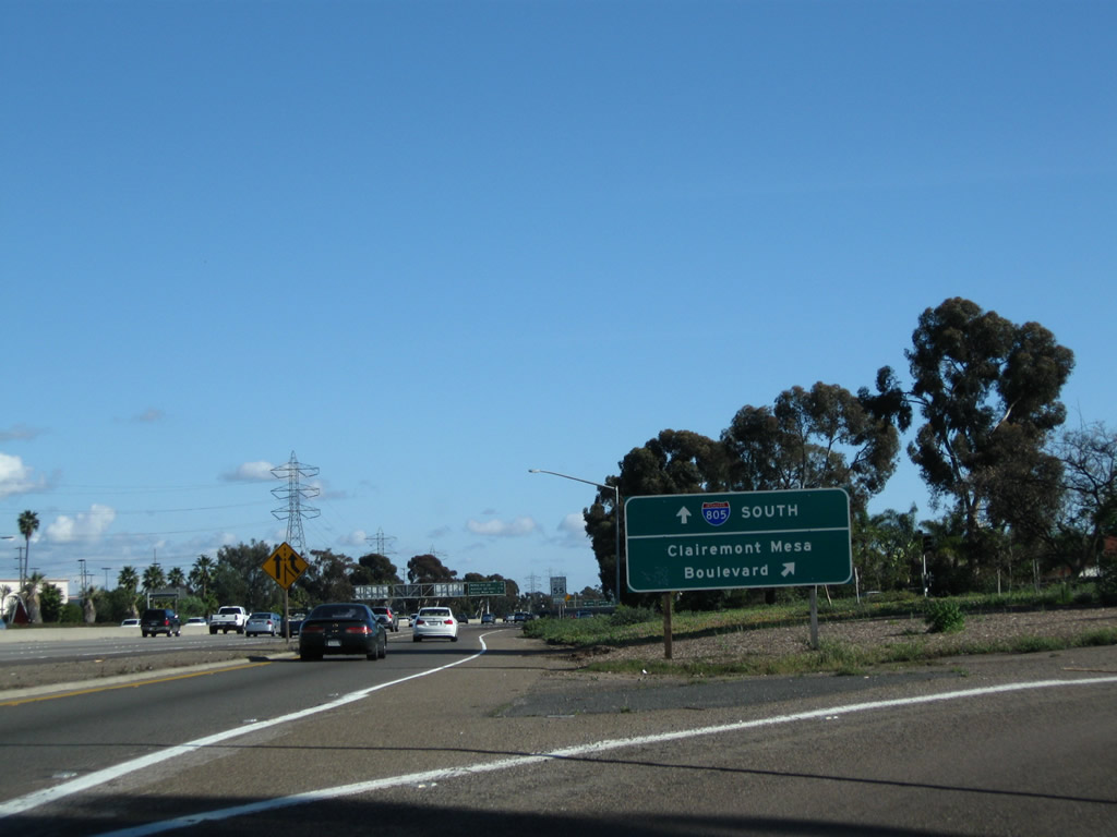
| Southbound Interstate 805 reaches Exit 22, Clairemont Mesa Boulevard. 04/09/11 |
|
| Now on the transition lane to Exit 22, the first ramp connects to westbound Clairemont Mesa Boulevard, while the second ramp connects to eastbound Clairemont Mesa Boulevard. 04/09/11 |
|
| This sign is located at the first gore point on the collector distributor lanes for this modified cloverleaf interchange with Clairemont Mesa Boulevard. 04/09/11, 04/23/06 |
|
| With the addition of traffic from westbound Clairemont Mesa Boulevard, the collector distributor lane continues south to rejoin the mainline of Interstate 805 south. 04/09/11, 04/23/06 |
|
| Back on the mainline, the next exit along southbound is Exit 21, Junction Former SR 274/Balboa Avenue, three-quarters of a mile. SR 274 was decommissioned in 2001, and Balboa Avenue is today maintained by the city of San Diego. Nevertheless, SR 274 reassurance shields remain along the route, and most of its intersections with freeways (Interstate 805, SR 163, and Interstate 15) currently (as of October 2004) have the shield posted on the exit signs, including this one. Only on Interstate 5 have the shields been removed from exit signs in both directions. 04/18/06 |
|
| This distance sign provides the distance to the next three exits: Exit 21, SR 274/Balboa Avenue; Exit 20, SR 163/Cabrillo Freeway south; and Exit 18, Murray Ridge Road. The interchange with SR 274 is a modified cloverleaf; exiting traffic should merge to the right lane for both directions of Balboa Avenue. 04/18/06 |
|
| Southbound Interstate 805 reaches Exit 21, Junction Former SR 274/Balboa Avenue. Use Balboa Avenue east to Kearny Mesa, Serra Mesa, and Tierrasanta; use Balboa Avenue west to Clairemont Mesa, Bay Park, and Pacific Beach. The next exit along southbound is Exit 20, SR 163/Cabrillo Freeway south (one mile). 04/18/06 |
|
| Now on the transition lane to Exit 21, the first ramp connects to westbound Balboa Avenue, while the second ramp connects to eastbound Balboa Avenue. 04/23/06 |
|
| This sign is located at the first gore point on the collector distributor lanes for this modified cloverleaf interchange with Balboa Avenue. The SR 274 shield still remains even though it was decommissioned in 2001. 04/23/06 |
|
| With the addition of traffic from westbound Balboa Avenue, the collector distributor lane continues south to rejoin the mainline of Interstate 805 south. 04/23/06 |
|
| Now back on the mainline of Interstate 805 south, the next three exits along southbound Interstate 805 are Exit 20, SR 163/Cabrillo Freeway south; Exit 18, Murray Ridge Road/Phyllis Place; and Exit 17B, Junction Interstate 8/Alvarado (Mission Valley) Freeway. The Interstate 8 shield partially covers up a state route shield. While the Mission Valley Freeway was briefly known as part of U.S. 80 (until 1964), we don't think it was ever a state route. It is possible that a state shield was used in error (perhaps SR 8), especially since Interstate 805 was not even fully opened until 1975. Other remote possibilities are that the freeway was erroneously posted as SR 80 (doubtful, since Interstate 8 already existed in 1975) or maybe SR 109, which was the brief, former designation of Interstate 8 west of Interstate 5. Note that the shield is the same size as the SR 163 shield at the top of the distance sign. 07/18/04 |
|
| After traffic from Balboa Avenue (former SR 274) merges onto southbound Interstate 805, the right two lanes become exit-only for SR 163/Cabrillo Freeway south. The left four lanes remain for through traffic on southbound Interstate 805. There is no connection to SR 163 northbound, because that is an illogical connection given the angle of the two intersecting routes. Use SR 163 south to reach downtown San Diego; Interstate 805 steers to the east of downtown, passing by North Park and City Heights instead. 04/18/06 |
|
| The interchange between Interstate 805 and SR 163 is a stack interchange, with only four connections rather than eight: from southbound to southbound and from northbound to northbound. Prior to 1964, SR 163 was designated as U.S. 395. Since U.S. 395 was replaced by Interstate 15 and Interstate 215 between San Diego and Hesperia, it made more sense to orphan the Cabrillo Freeway with its own designation rather than co-sign U.S. 395 with Interstate highways all the way to San Diego. SR 163 is not an Interstate highway because of its substandard construction south of the 6th Avenue/University Avenue/Washington Street interchange (limited sight distance, curves, and narrow shoulders). 04/23/06 |
|
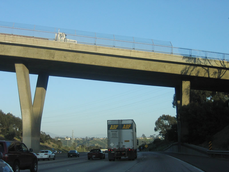
| Interstate 805 passes on the bottom level of this stack interchange. Prior to SR 163 crossing over the freeway, Linda Vista Road (Convoy Street) passes over Interstate 805 (this is the first bridge seen in this interchange complex). 07/18/04 |
|
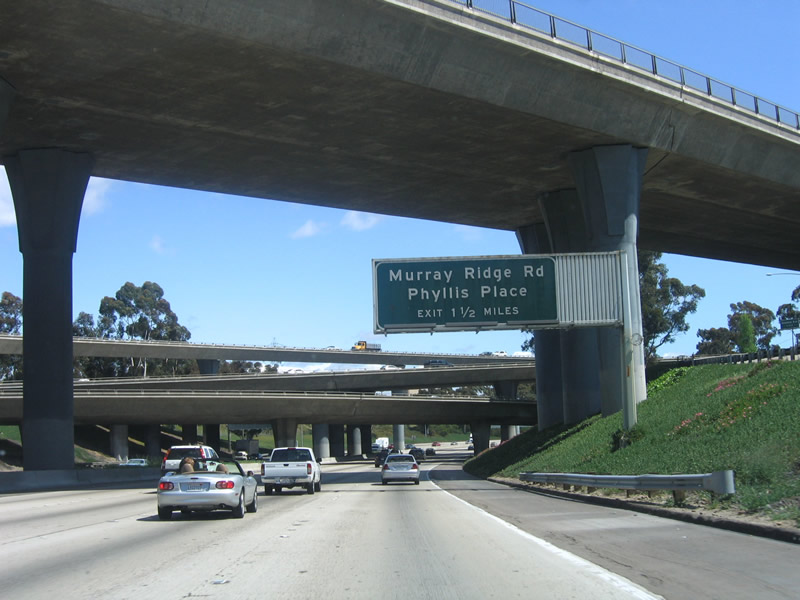
| The next exit along southbound Interstate 805 is Exit 18, Murray Ridge Road/Phyllis Place, 1.50 miles. 04/23/06 |
|
| The next three exits along southbound are: Exit 18, Murray Ridge Road/Phyllis Place; Exit 17B, Junction Interstate 8/Alvarado (Mission Valley) Freeway; and Exit 17A, Adams Avenue. 04/23/06 |
|
| Exit 18, Murray Ridge Road/Phyllis Place, is the only interchange to serve southern Serra Mesa. Use Murray Ridge Road north to Serra Mesa and also to Mission Center Road, which extends south into Mission Valley. If Interstate 8 is congested, Mission Center Road is an excellent alternate route to Friars Road, Mission Valley Center, Fashion Valley, and other shopping amenities. This sign was knocked down in winter 2006 by an accident in the northbound lanes; it has not been replaced. 07/18/04 |
|
| Southbound Interstate 805 reaches Exit 18, Murray Ridge Road/Phyllis Place, and the next exit is Exit 17, Junction Interstate 8/Alvarado (Mission Valley) Freeway. 04/23/06 |
|
| The next exit along southbound Interstate 805 is Exit 17B, Junction Interstate 8, after the Murray Ridge Road exit. Interstate 8 eastbound leads to the San Diego suburbs of La Mesa and El Cajon before entering the unincorporated backcountry of San Diego. 07/18/04, 04/18/06 |
|
| The next three exits along southbound are: Exit 17B, Junction Interstate 8/Alvarado (Mission Valley) Freeway; Exit 17A, Adams Avenue; and Exit 16, Junction Business Loop I-8/El Cajon Boulevard. Interstate 805 travels high above the floor of Mission Valley now, and it is a bridge that does not extend to the floor of Mission Valley. Interstate 15 and SR 163 both enter Mission Valley; Interstate 805 stays above it. 04/18/06 |
|
| The left four lanes continue as Interstate 805/Dekema Freeway extend across the top of Mission Valley, while the two right lanes exit onto Interstate 8. Interstate 8 is the primary east-west freeway in central San Diego, and it parallels the San Diego River as it passes through Mission Valley. To the east, Interstate 8 connects to the Del Cerro, San Diego State University/College Area, Rolando, and San Carlos neighborhoods of San Diego before entering the city of La Mesa. To the west, Interstate 8 connects to Interstate 5, then ends in Mission Bay Park. From its western terminus, local streets (Sports Arena Boulevard, Nimitz Boulevard, Sunset Cliffs Boulevard, Mission Bay Drive, and Ingraham Street) emanate to the Midway District, Point Loma, Ocean Beach, Mission Beach, and Pacific Beach. 04/18/06 |
|
| Southbound Interstate 805 reaches Exit 17B, Junction Interstate 8. Interstate 805 flies over the top of Mission Valley on an impressive bridge, and the symmetrical stack interchange is barely visible from Interstate 805 itself. The entire interchange, officially known as "Jack Schrade Interchange/Mission Valley Viaduct," was constructed in 1972 and opened in 1973 is best seen from Interstate 8 on the floor of the valley. 04/18/06 |
|
| Now exiting from the Jack Schrade bridge, the signs for the Interstate 8 ramp show the lane allocation for both directions. The right lane transitions onto Interstate 8 westbound, while the left lanes lead to eastbound Interstate 8. 04/18/06 |
|
| The next two exits along southbound Interstate 805 after the Interstate 8 interchange are Exit 17A, Adams Avenue/Madison Avenue and Exit 16, Junction Business Loop I-8/El Cajon Boulevard. 04/23/06, 08/16/04 |
|
| Interstate 805 departs Mission Valley and now serves as the boundary between the Mid-City and North Park communities. Between 1912 and 1925, this corridor separated the city of San Diego with what used to be the city of East San Diego. East San Diego was created from unincorporated county in 1912, and it was subsumed into the city of San Diego in stages between 1923 and 1925. Separating these two cities was Boundary Street, and Boundary Street kept its name even after East San Diego merged with San Diego. Boundary Street was a community division between North Park to the west and Normal Heights and City Heights (Mid-City) to the east, and it became the corridor for Interstate 805 when it opened in 1975. Many of the streets in North Park (to the west) are named after presidents, and some of them (including Adams and Madison Avenues) continue east into Normal Heights. 04/23/06 |
|
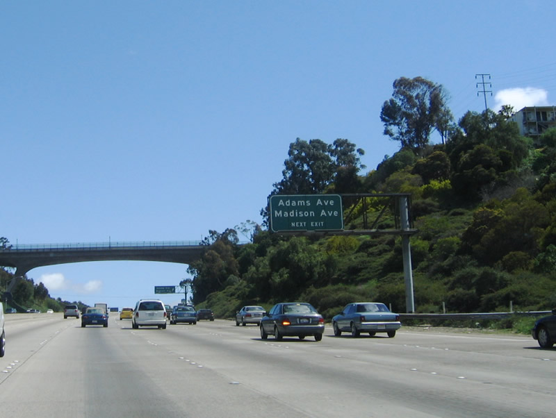
| Southbound Interstate 805 approaches Exit 17A, Adams Avenue and Madison Avenue just south of the Interstate 8 exit (Exit 17B). Interstate 805 has six lanes on southbound, partially due to the steep grade from the Jack Schrade Interchange/Mission Valley Viaduct south to the Adams Avenue exit ramp. The bridge visible over the freeway ahead carries Adams Avenue over Interstate 805. 04/23/06 |
|
| Southbound Interstate 805/Dekema Freeway reaches Exit 17A, Adams Avenue and Madison Avenue. At the top of the ramp, continue straight ahead onto Madison Avenue westbound. To reach Adams Avenue, make a right on Ohio Street or 30th Street north. Adams Avenue is one block north of Madison Avenue. From there, turn left for westbound Adams Avenue or right for eastbound Adams Avenue across Interstate 805 to Normal Heights and Kensington. 04/23/06, 08/16/04 |
|
| This ramp does not connect directly to Adams Avenue, but it transitions directly onto Madison Avenue. At the top of the offramp at Exit 17A, turn right (north) onto Ohio Street to connect to east-west Adams Avenue. Continue straight ahead to Madison Avenue westbound, or turn left (south) onto Ohio Street to downtown North Park. 04/14/05 |
|
| The next exit along southbound Interstate 805 is Exit 16, Junction Business Loop I-8 and Historic U.S. 80/El Cajon Boulevard. El Cajon Boulevard is the original route of U.S. 80 before the designation was transferred to the Mission Valley (Alvarado) Freeway in June 1953. Between 1953 and 1964, the current Interstate 8 corridor was signed as U.S. 80, while El Cajon Boulevard was signed as Business U.S. 80. With the legal elimination of U.S. 80 on July 1, 1964 (and the subsequent removal of signs completed by 1972), U.S. 80 became Interstate 8 and Business U.S. 80 became Business Loop I-8. Between 1964 and 2002, Business Loop I-8 was reasonably well-signed along El Cajon Boulevard (the business route extends from SR 163 in University Heights/Hillcrest east to Interstate 8 in La Mesa). However, in 2002, most of the business loop shields were removed from El Cajon Boulevard and Washington Street in University Heights and North Park, and the remaining shields in City Heights, Talmadge, and College Area are endangered. In La Mesa, no business loop shields remain at all. 04/23/06 |
|
| Southbound Interstate 8 reaches Exit 16, Junction Business Loop I-8 and Historic U.S. 80/El Cajon Boulevard. The right lane (#6 lane) exits only to El Cajon Boulevard. Use El Cajon Boulevard east to City Heights and Mid-City; use El Cajon Boulevard west to North Park, University Heights, and Hillcrest. There are no business loop shields anywhere near this interchange. 04/23/06 |
|
| One of the first reflective signs to appear on San Diego's freeway system was the series of signs approaching the SR 94/Martin Luther King, Jr. Freeway interchange along southbound Interstate 805. These new signs all popularized the naming of SR 94 as the Martin Luther King, Jr. Freeway, and the city of San Diego paid for the manufacturing and installation of these signs. The next two exits along southbound Interstate 805 are Exit 16, North Park Way/University Avenue and Exit 15, SR 94/Martin Luther King, Jr. Freeway. 04/23/06 |
|
| North Park Way is a relatively short east-west street that begins at the top of the exit ramp and heads west to the North Park Library and the Post Office. This exit also connects to University Avenue via a trip one block north on Boundary Street to University Avenue. University Avenue is a lengthy east-west city street, originating in Mission Hills at its interchange with Washington Street east through Hillcrest, University Heights, North Park, Mid-City/City Heights, College Area, Rolando, and ultimately the city of La Mesa, where it ends at Baltimore Drive southwest of Grossmont Center. 04/23/06 |
|
| Southbound Interstate 805 reaches Exit 15, North Park Way and University Avenue. Once again, this is an exit-only lane (formed by the onramp from El Cajon Boulevard). 04/23/06 |
Page Updated 04-11-2011.

 South
South