| Interstate 880 (Nimitz Freeway) north |
|
The first reassurance shield for Interstate 880 is posted after the Interstate 280 and California 17 interchange. This shield is located after the on-ramp from San Carlos Street and Stevens Creek Boulevard. The first seven miles of Interstate 880 is located in the city of San Jose, which is home to 894,943 people as of the 2000 Census. Founded on November 29, 1777, and incorporated on March 27, 1850, San Jose is the third largest city in California (behind Los Angeles and San Diego). San Jose consists of 178.2 square miles and sits at an elevation of 85 feet. Rainfall in San Jose is much less than San Francisco due to its location at the south end of the San Francisco Bay and enclosure within mountains. The average annual precipitation is 14.4 inches. Photo taken 11/29/04. |
|
The first four exits along Interstate 880 north are: Exit 1A, Bascom Avenue south; Exit 1B, Bascom Avenue north to the city of Santa Clara; Exit 2, California 82/The Alameda; and Exit 3, Coleman Avenue to the Norman Y. Mineta San Jose International Airport. Photo taken 11/29/04. |
|
The right lane becomes exit only for Exit 1A, Bascom Avenue south and Exit 1B, Bascom Avenue north to the city of Santa Clara. Photo taken 11/29/04. |
|
Northbound Interstate 880 reaches Exit 1A, Bascom Avenue south. The exit only lane connects to a loop ramp to Exit 1B, Bascom Avenue north to the city of Santa Clara. Photo taken 11/29/04. |
|
Immediately thereafter, Interstate 880 north reaches Exit 1B, Bascom Avenue north to the city of Santa Clara. Photo taken 11/29/04. |
|
This Interstate 880 reassurance shield is posted after Exits 1A-B, Bascom Avenue and prior to Exit 2, California 82/The Alameda. Photo taken 11/29/04. |
|
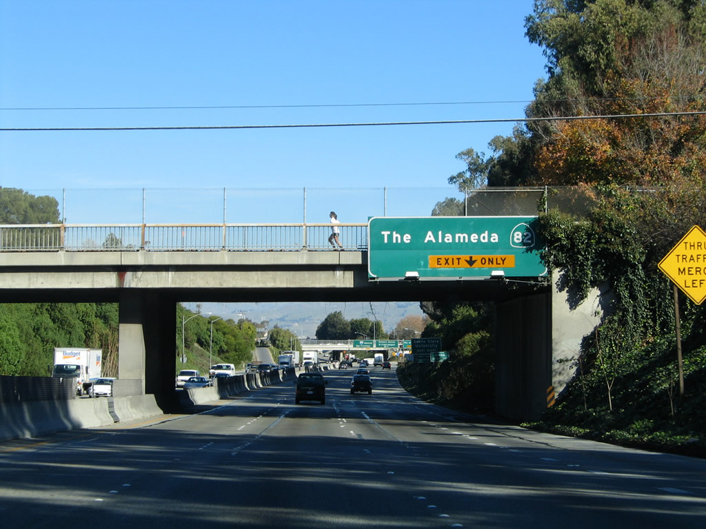
The right lane of Interstate 880 north becomes exit only for Exit 2, California 82/The Alameda. The left three lanes continue north on Interstate 880 to Oakland. Photo taken 11/29/04. |
|
Use California 82/The Alameda southeast to San Jose Convention Center, the HP Pavilion at San Jose, and downtown San Jose. Use California 82/The Alameda northwest to the city of Santa Clara, including the Mission Santa Clara and Santa Clara University. Photo taken 11/29/04. |
|
|
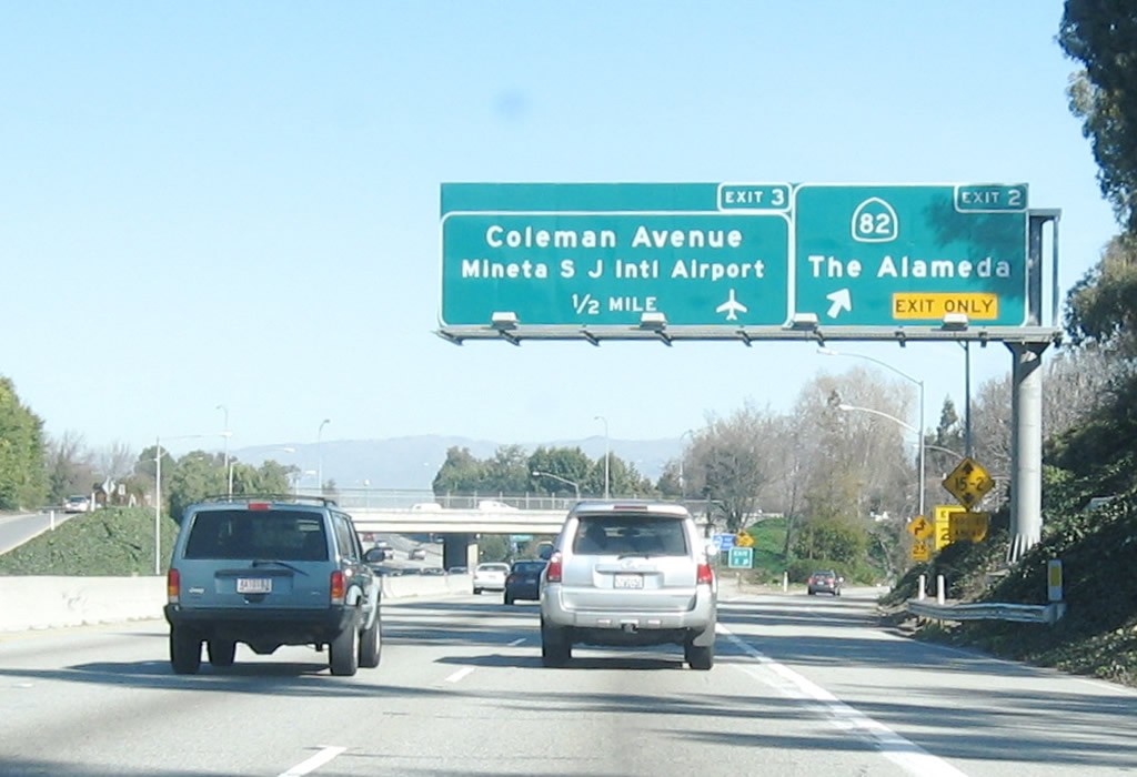
Northbound Interstate 880 north reaches Exit 2, California 82/The Alameda. The next interchange along northbound is Exit 3, Coleman Avenue to the Norman Y. Mineta San Jose International Airport. Notably, the sign bridge and overhead sign panels were replaced between 2004 and 2007. Photos taken 11/29/04 and by Jeff Waller (10/13/07). |
|
Use Exit 3, Coleman Avenue northwest to the Norman Y. Mineta San Jose International Airport and southeast to the HP Pavilion at San Jose and downtown San Jose. Photo taken 11/29/04. |
|
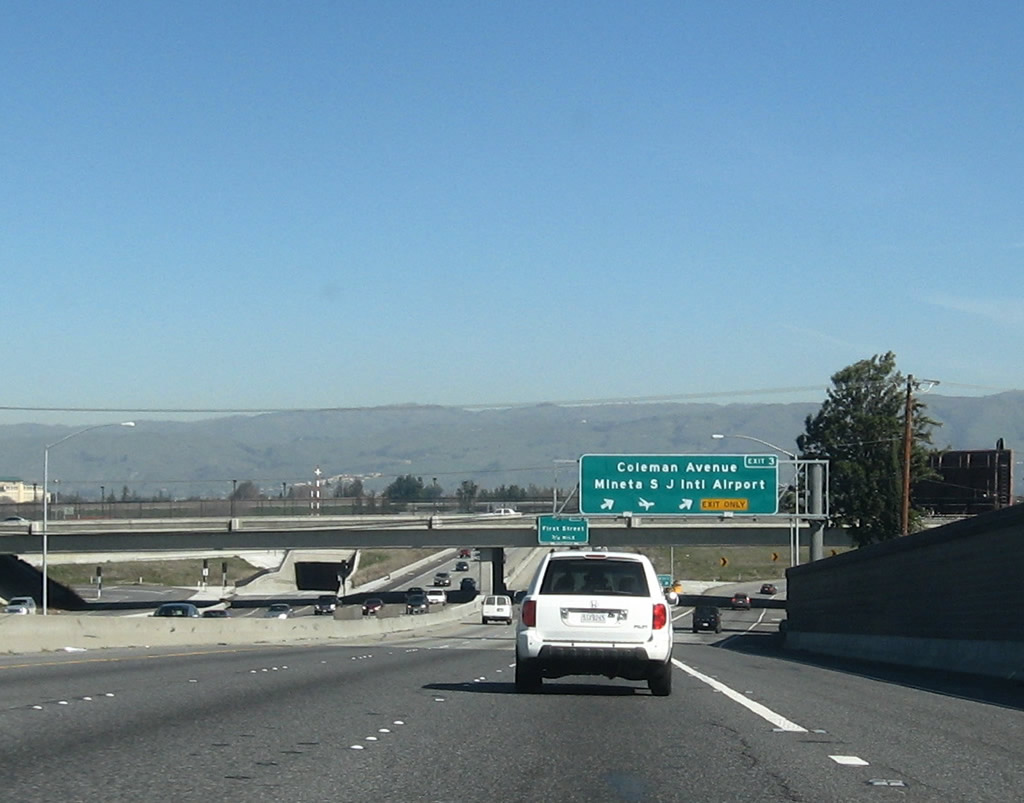
The next four exits along Interstate 880 north are: Exit 3, Coleman Avenue to the Norman Y. Mineta San Jose International Airport; Exit 4A, First Street; Exit 4B, U.S. 101 (Bayshore Freeway) south to Los Angeles; and Exit 4C, U.S. 101 (Bayshore Freeway) north to San Francisco. Photo taken 11/29/04. |
|
|
Northbound Interstate 880 reaches Exit 3, Coleman Avenue to the Norman Y. Mineta San Jose International Airport. The interchange was reconfigured between 2004 and 2007. Photos taken 11/29/04 and by Jeff Waller (10/13/07). |
|
The next exit along Interstate 880 north is Exit 4A, First Street. Note the change in bridge structure between 2004 and 2007. Photo taken by Jeff Waller (10/13/07). |
|
The next four exits along Interstate 880 north are: Exit 4A, First Street; Exit 4B, U.S. 101 (Bayshore Freeway) south to Los Angeles; Exit 4C, U.S. 101 (Bayshore Freeway) north to San Francisco; and Exit 4D, Gish Road, Old Bayshore Highway, and 10th Street. Photo taken by Jeff Waller (10/13/07). |
|
|
Northbound Interstate 880 reaches Exit 4A, First Street. The signs for this interchange were between 2004 and 2007, removing one of the few remaining outline U.S. 101 porcelain enamel overhead signs from service. Photos taken 11/29/04 and by Jeff Waller (10/13/07). |
|
The next four exits along Interstate 880 north are: Exit 4B, U.S. 101 (Bayshore Freeway) south to Los Angeles; Exit 4C, U.S. 101 (Bayshore Freeway) north to San Francisco; Exit 4D, Gish Road, Old Bayshore Highway, and 10th Street; and Exit 5, Brokaw Road. Photo taken 11/29/04. |
|
Northbound Interstate 880 reaches Exit 4B, U.S. 101 (Bayshore Freeway) south to Los Angeles. The next ramp in this near-cloverleaf interchange connects to Exit 4C, U.S. 101 (Bayshore Freeway) north to San Francisco. Photo taken 11/29/04. |
|
Immediately thereafter, northbound Interstate 880 reaches Exit 4C, U.S. 101 (Bayshore Freeway) north to San Francisco. This loop ramp offers a direct connection to U.S. 101 north. The next exit is Exit 4D, Gish Road, Old Bayshore Highway, and 10th Street. Photo taken 11/29/04. |
|
Northbound Interstate 880 (Nimitz Freeway) reaches Exit 4D, Gish Road, Old Bayshore Highway, and 10th Street. Photo taken 11/29/04. |
|
The next three exits along Interstate 880 (Nimitz Freeway) north are Exit 5, Brokaw Road; Exit 7, Santa Clara County G-4 (Montague Expressway); and Exit 8A, Great Mall Parkway. Photo taken 11/29/04. |
|
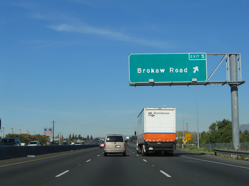
Use Exit 5, Brokaw Road west to Norman Y. Mineta San Jose International Airport (in case you missed Exit 3). Photo taken 11/29/04. |
|
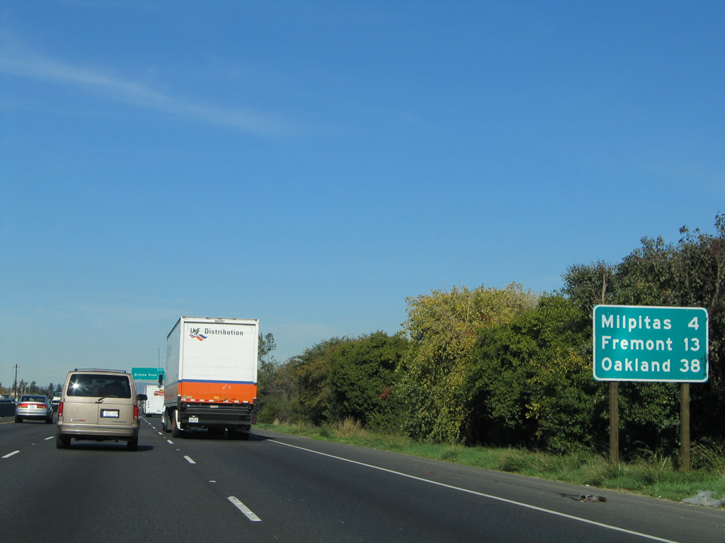
This mileage sign provides the distance to Milpitas (four miles), Fremont (13 miles), and Oakland (38 miles). Photo taken 11/29/04. |
|
Northbound Interstate 880 (Nimitz Freeway) reaches Exit 5, Brokaw Road. Photo taken 11/29/04. |
|
The next exit along Interstate 880 (Nimitz Freeway) north is Exit 7, Santa Clara County G-4 (Montague Expressway). San Jose features a tiered structure of roadways. Interstate 880, Interstate 280, Interstate 680, U.S. 101, California 85, and the completed portions of California 87 are all freeways. The Santa Clara Countys are all expressways, with some limited access and traffic lights at major intersections. Santa Clara County G-4 is the San Tomas Expressway from California 17 Exit 23 north to U.S. 101 Exit 392 and the Montague Expressway from U.S. 101 Exit 392 east to Interstate 680 Exit 6. Other Santa Clara Countys that are in the expressway system include: G2 (Lawrence Expressway), G5 (Foothill Expressway), G6 (Central Expressway), and G8 (Almaden Expressway). Photo taken 11/29/04. |
|
The next three exits along Interstate 880 north are Exit 7, Santa Clara County G-4 (Montague Expressway); Exit 8A, Great Mall Parkway and Tasman Drive; and Exit 8B, California 237 (South Bay Freeway) west to Sunnyvale and California 237 (Calaveras Boulevard) east to Interstate 680. Photo taken 11/29/04. |
|
Northbound Interstate 880 reaches Exit 7, Santa Clara County G-4 (Montague Expressway). Photo taken 11/29/04. |
|
Passing under the Montague Expressway, Interstate 880 leaves San Jose and enters the city of Milpitas. Situated on Interstate 680, Interstate 880, and California 237, Milpitas is known as the "Crossroads of Silicon Valley" with its freeway access. Home to 62,698 people as of the 2000 Census, Milpitas was incorporated as a city on January 26, 1954, as it was threatened with potential annexation by the city of San Jose. Milpitas is the second and final city along Interstate 880 in Santa Clara County; near Exit 10 (Dixon Landing Road), Interstate 880 will leave Santa Clara County and enter Alameda County. Photo taken by Jeff Waller (10/13/07). |
|
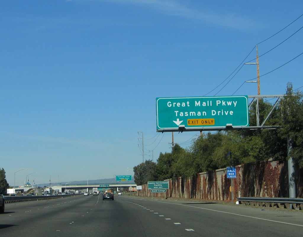
The next exit along Interstate 880 (Nimitz Freeway) north is Exit 8A, Great Mall Parkway and Tasman Drive. The right lane becomes exit only for Exit 8A. Use Great Mall Parkway east to the Elmwood Correctional Facility and Great Mall of the Bay Area. Use Tasman Drive west to Agnews Developmental Center; a light rail system follows this corridor from Sunnyvale east through northern Santa Clara and northern San Jose to Milpitas. Tasman Drive and its light rail corridor link Paramount's Great America with the Great Mall. Photo taken 11/29/04. |
|
Northbound Interstate 880 reaches Exit 8A, Great Mall Parkway and Tasman Drive. Photo taken 11/29/04. |
|
The next three exits along Interstate 880 north are Exit 8B, California 237 (South Bay Freeway) west to Sunnyvale and California 237 (Calaveras Boulevard) east to Interstate 680; Exit 10, Dixon Landing Road; and Exit 12, California 262 (Mission Boulevard) northeast to Interstate 680 and the Warm Springs district of the city of Fremont. Photo taken 11/29/04. |
|
|
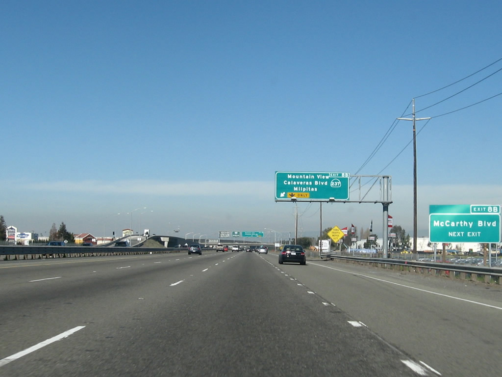
The right lane becomes exit only for Exit 8B, California 237 (South Bay Freeway) west to Sunnyvale and California 237 (Calaveras Boulevard) east to Interstate 680. California 237 is a freeway corridor from Interstate 880 west to U.S. 101, but it is a surface street (expressway) from Interstate 880 east to Interstate 680. Photo taken 11/29/04. Note the 2007 addition of a roadside auxiliary sign for McCarthy Boulevard. Photos taken 11/29/04 and by Jeff Waller (10/13/07). |
|
Northbound Interstate 880 (Nimitz Freeway) reaches Exit 8B, California 237 (South Bay Freeway) west to Sunnyvale and California 237 (Calaveras Boulevard) east to Interstate 680. The left three lanes continue north on Interstate 880 to Fremont, Hayward, and Oakland. Photo taken 11/29/04. |
|
The connection to California 237 (South Bay Freeway) west and California 237 (Calaveras Boulevard) east is afforded via this traffic signal. Note the state name in the California 237 shield. Photo taken 11/29/04. |
|
At the top of the ramp is this trailblazer signage for California 237 west to Sunnyvale and California 237 east to Milpitas. Photo taken 11/29/04. |
|
The next three exits along Interstate 880 north are Exit 10, Dixon Landing Road; Exit 12, California 262 (Mission Boulevard) northeast to Interstate 680 and the Warm Springs district of the city of Fremont; and Exit 13A, Gateway Boulevard. Photo taken 12/23/04. |
|
A mileage sign shortly thereafter provides the distance to Fremont (eight miles) and the control city of Oakland (33 miles). Photo taken 12/23/04. |
|
The right lane of Interstate 880 (Nimitz Freeway) north becomes exit only for Exit 10, Dixon Landing Road. Photo taken 12/23/04. |
|
Northbound Interstate 880 (Nimitz Freeway) reaches Exit 10, Dixon Landing Road. The next interchange is Exit 12, California 262 (Mission Boulevard) northeast to Interstate 680 and the Warm Springs district of the city of Fremont. Photo taken 12/23/04. |
|
Exit 10 was realigned so that all departing traffic would exit onto one off-ramp for both directions of Dixon Landing Road. Previously, exiting traffic had two separate ramps (old Exit 10A and Exit 10B) to Dixon Landing Road east and west. Use the Dixon Landing Road east exit to California Circle. Photo taken 12/23/04. |
|
These signs direct exiting traffic to east and west Dixon Landing Road on the Exit 10 off-ramp. The off-ramp functions as a collector distributor lane, since entering traffic merges with the exiting traffic. Photo taken 12/23/04. |
|
Looking at the collector distributor lane for Exit 10, this sign is posted at the off-ramp to Dixon Landing Road west. Photo taken 12/23/04. |
|
At the end of the on-ramp from Exit 10, Dixon Landing Road, northbound Interstate 880 leaves the city of Milpitas and Santa Clara County and enters the city of Fremont and Alameda County. Photo taken 12/23/04. |
Page Updated February 23, 2008.