
Interstate 880 South - Santa Clara County
| Interstate 880 (Nimitz Freeway) south | |
|---|---|
 |
After the Dixon Landing Road interchange, Interstate 880 leaves Alameda County and enters Santa Clara County. At this point, Interstate 880 leaves Fremont and enters the city of Milpitas. Situated on Interstate 680, Interstate 880, and California 237, Milpitas is known as the "Crossroads of Silicon Valley" with its freeway access. Home to 62,698 people as of the 2000 Census, Milpitas was incorporated as a city on January 26, 1954, as it was threatened with potential annexation by the city of San Jose. Milpitas is the first city along Interstate 680 in Santa Clara County after leaving Alameda County; this county line is demarcation point between the regional nomenclature of "East Bay" and "South Bay." A new high occupancy vehicle lane emerges on the left, along with four general purpose lanes for through traffic. After the on-ramp, an auxiliary lane allows for the connection to California 237 west via Exit 8C. Photo taken 08/05/05. |
 |
The next four exits along Interstate 880/Admiral Chester Nimitz Freeway south are: Exit 8C, California 237 (South Bay Freeway) west; Exit 8B, California 237 (Calaveras Boulevard) east and McCarthy Boulevard; Exit 8A, Great Mall Parkway and Tasman Drive; and Exit 7, Santa Clara County G-4 (Montague Expressway). Photo taken 08/05/05. |
 |
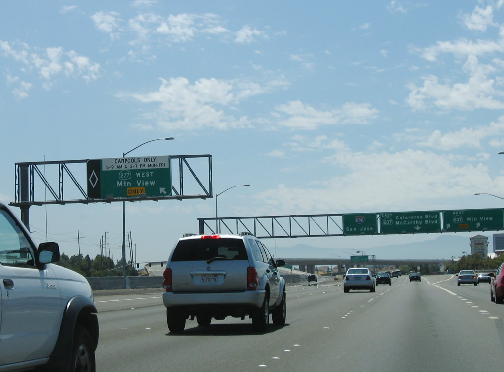
Two ramps connect Interstate 880 south to Exit 8C, California 237 (South Bay Freeway) west. The left exit is for high occupancy vehicles (carpools) during commuting hours, and the right exit is available at all times for general traffic. Photo taken 08/05/05. |
 |
A roadside sign is posted for Exit 8B, California 237 (Calaveras Boulevard) east and McCarthy Boulevard (second right). Photo taken 08/05/05. |
 |
The right two lanes become exit only for Exit 8C, California 237 (South Bay Freeway) west (next right). Photo taken 11/25/07. |
 |
Another roadside sign is posted for Exit 8B, California 237 (Calaveras Boulevard) west and McCarthy Boulevard, while the left lane becomes exit only for the HOV access to California 237 west. The middle four lanes continue south on Interstate 880. Photo taken 08/05/05. |
 |
This is a closer view of the roadside sign for Exit 8B seen in the previous photo. Photo taken 11/25/07. |
 |
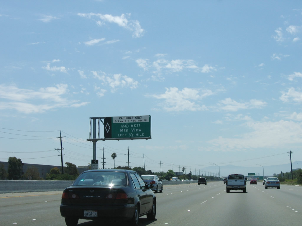
The left lane departs southbound Interstate 880 for high occupancy vehicle access to Exit 8C, California 237 (South Bay Freeway) west. Photo taken 08/05/05. |
 |
Southbound Interstate 880 reaches Exit 8C, California 237 west freeway to Mountain View. The next exit is Exit 8B, California 237 east to Milpitas via Calaveras Boulevard. Photo taken 08/05/05. |
 |
Immediately thereafter, Interstate 880 (Nimitz Freeway) south reaches Exit 8B, California 237 (Calaveras Boulevard) east. Photo taken 08/05/05. |
 |
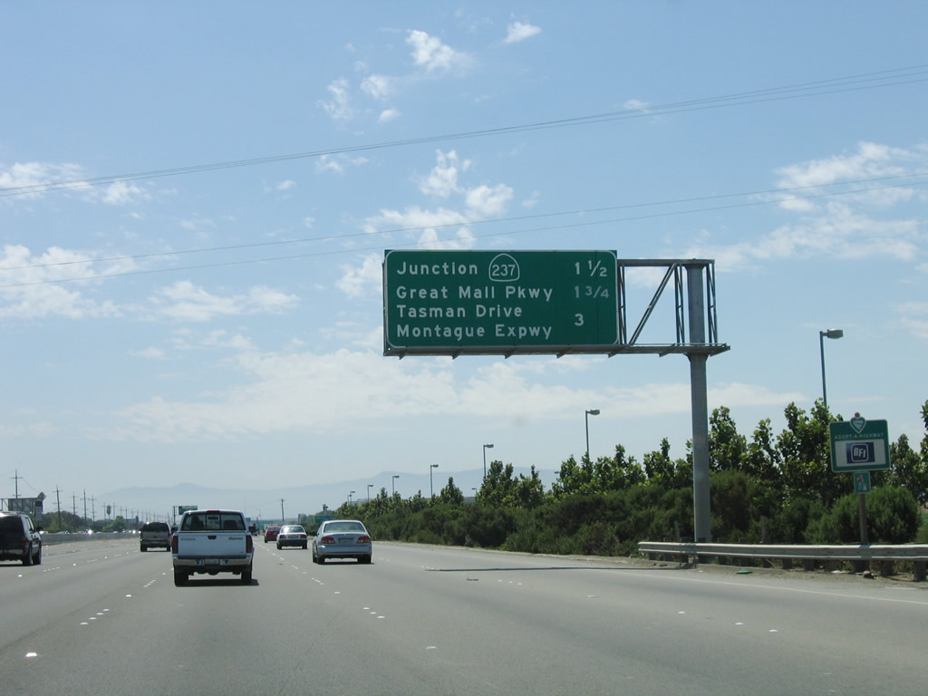
The next exit along Interstate 880 (Nimitz Freeway) south is Exit 8A, Great Mall Parkway/Tasman Drive. Photo taken 08/05/05. |
 |
This mileage sign provides the distance to the next three exits along Interstate 880 (Nimitz Freeway) south: Exit 8A, Great Mall Parkway and Tasman Drive; Exit 7, Santa Clara County G-4 (Montague Expressway); and Exit 5, Brokaw Road and Otoole Avenue. Photo taken 08/05/05. |
 |
Southbound Interstate 880 (Nimitz Freeway) reaches Exit 8A, Great Mall Parkway and Tasman Drive. Note the handrail in front of the sign, which might imply that this sign was erected only a short time before this picture was taken. Photo taken 08/05/05. |
 |
The next exit along Interstate 880 (Nimitz Freeway) south is Exit 7, Santa Clara County G-4 (Montague Expressway). San Jose features a tiered structure of roadways. Interstate 880, Interstate 280, Interstate 680, U.S. 101, California 85, and the completed portions of California 87 are all freeways. The Santa Clara Countys are all expressways, with some limited access and traffic lights at major intersections. Santa Clara County G-4 is the San Tomas Expressway from California 17 Exit 23 north to U.S. 101 Exit 392 and the Montague Expressway from U.S. 101 Exit 392 east to Interstate 680 Exit 6. Other Santa Clara Countys that are in the expressway system include: G2 (Lawrence Expressway), G5 (Foothill Expressway), G6 (Central Expressway), and G8 (Almaden Expressway). Photo taken 08/05/05. |
 |
This mileage sign provides the distance to the next four exits along Interstate 880 (Nimitz Freeway) south: Exit 7, Santa Clara County G-4 (Montague Expressway); Exit 5, Brokaw Road and Otoole Avenue; Exit 4C, Old Bayshore Highway to U.S. 101 (Bayshore Freeway) north and 10th Street south; and Exit 4B, U.S. 101 (Bayshore Freeway) south. Photo taken 08/05/05. |
 |
The right lane of Interstate 880 (Nimitz Freeway) south becomes exit only for Exit 7, Santa Clara County G-4 (Montague Expressway). The county route appears to be unsigned from the mainline of Interstate 880. Photo taken 08/05/05. |
 |
Southbound Interstate 880 (Nimitz Freeway) reaches Exit 7, Santa Clara County G-4 (Montague Expressway). Photo taken 08/05/05. |
 |
The next exit along Interstate 880 (Nimitz Freeway) south is Exit 5, Brokaw Road, one mile. Interstate 880 leaves the city of Milpitas and enters the city of San Jose here, at the overpass for Santa Clara County G-4 (Montague Expressway). The city of San Jose is home to 894,943 people as of the 2000 Census. Founded on November 29, 1777, and incorporated on March 27, 1850, San Jose is the third largest city in California (behind Los Angeles and San Diego). San Jose consists of 178.2 square miles and sits at an elevation of 85 feet. Rainfall in San Jose is much less than San Francisco due to its location at the south end of the San Francisco Bay and enclosure within mountains. The average annual precipitation is 14.4 inches. Photo taken 08/05/05. |
 |
This mileage sign provides the distance to the next three exits along Interstate 880 (Nimitz Freeway) south: Exit 5, Brokaw Road and Otoole Avenue; Exit 4C, Old Bayshore Highway to U.S. 101 (Bayshore Freeway) north and 10th Street south; and Exit 4B, U.S. 101 (Bayshore Freeway) south. Photo taken 08/05/05. |
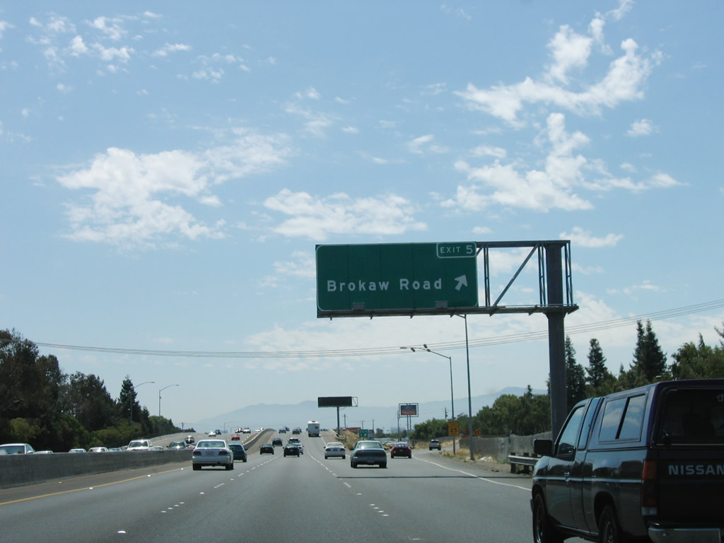 |
Southbound Interstate 880 (Nimitz Freeway) reaches Exit 5, Brokaw Road and Otoole Avenue. Access to Brokaw Road is made by following Otoole Avenue south. Use Brokaw Avenue west to the Norman Y. Mineta San Jose International Airport. To the east, Brokaw Road changes into Murphy Avenue at Old Oakland Road, and Murphy Avenue changes into Hostetter Road after passes Lundy Avenue. Hostetter Road meets Interstate 680 at Exit 5A. Photo taken 08/05/05. |
 |
The next exit along Interstate 880 (Nimitz Freeway) south is Exit 4C, Old Bayshore Highway to U.S. 101 north to San Francisco and 10th Street south to downtown San Jose and San Jose State University. The connection to U.S. 101 north is not a freeway-to-freeway connection; traffic must use Old Bayshore Highway as part of the connection. Photo taken 08/05/05. |
 |
All of the remaining exits of Interstate 880 serve the city of San Jose: Exit 4C, Old Bayshore Highway to U.S. 101 (Bayshore Freeway) north to San Francisco; Exit 4B, U.S. 101/Bayshore Highway south to Los Angeles; Exit 4A, First Street (Downtown San Jose via First Street south); Exit 3, Coleman Avenue to Norman Y. Mineta San Jose International Airport; Exit 2, California 82/The Alameda to Santa Clara; Exit 1D, Bascom Avenue; Exit 1C, Stevens Creek Boulevard and West San Carlos Street; and Exit 1B, Interstate 280 (Sinclair Freeway) east to downtown San Jose and Interstate 280 (Father Junipero Serra Freeway) north to San Francisco. At that point, through traffic on Interstate 880 south defaults onto Exit 1A, Junction 17/Santa Cruz Highway south. Photo taken 08/05/05. |
 |
This auxiliary exit number sign is the only advance signage that Exit 4C connects to 10th Street south to downtown San Jose and to the east side of San Jose State University. Photo taken 11/25/07. |
 |
Southbound Interstate 880 (Nimitz Freeway) reaches Exit 4C, Old Bayshore Highway to U.S. 101 north to San Francisco and 10th Street south to downtown San Jose and San Jose State University. Northbound U.S. 101 is the most direct route from San Jose to San Francisco, but due to traffic, it may not always be the fastest route between the two cities (Interstate 280 is usually a better alternative). The connection to U.S. 101 north is not a freeway-to-freeway connection; traffic must use Old Bayshore Highway as part of the connection. Photo taken 08/05/05. |
 |
This mileage sign provides the distance to the next three exits along Interstate 880 (Nimitz Freeway) south: Exit 4B, southbound U.S. 101 (Bayshore Freeway); Exit 4A, First Street (Downtown San Jose via First Street south); and Exit 3, Coleman Avenue to Norman Y. Mineta San Jose International Airport. Photo taken 08/05/05. |
 |
Another advance guide sign is posted for the connection from Interstate 880 south to Exit 4B, U.S. 101 (Bayshore Freeway) south. This ramp is a loop ramp. Follow U.S. 101 south to the Central California Coast and Los Angeles. Photo taken 11/25/07. |
 |
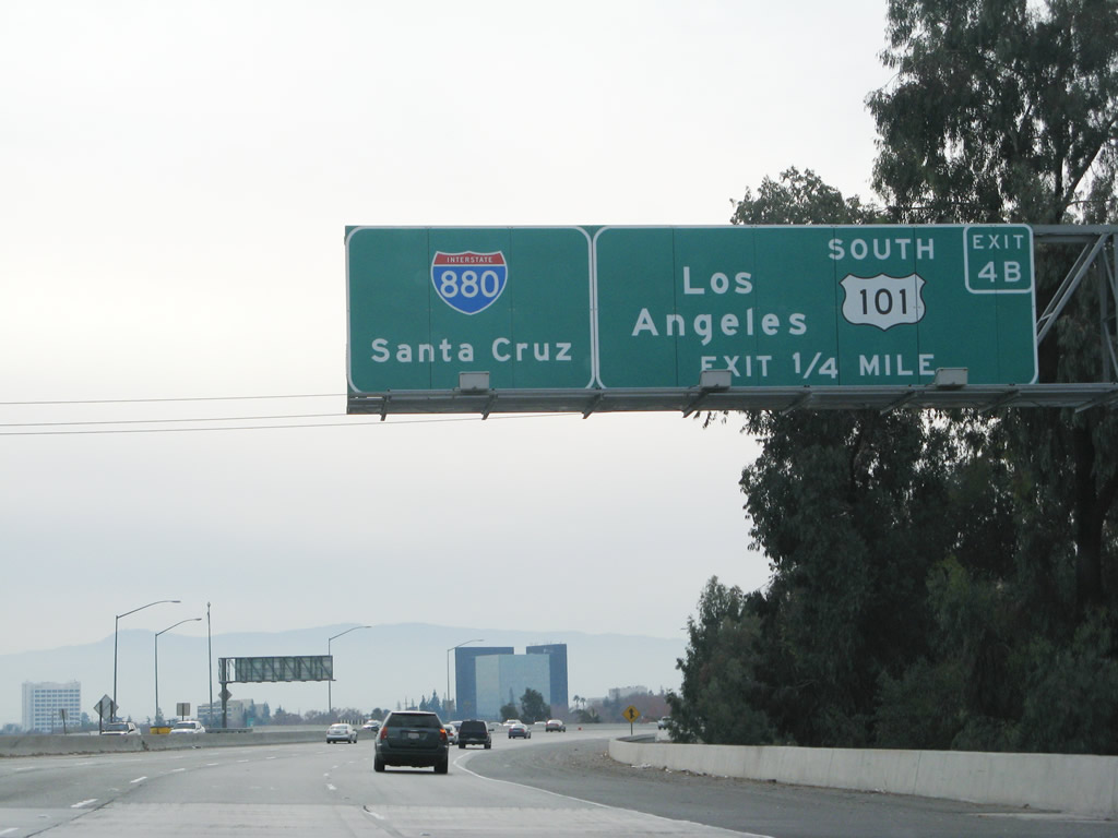
Southbound Interstate 880 reaches Exit 4B, southbound U.S. 101 (Bayshore Freeway). U.S. 101 south is signed for Los Angeles here in San Jose by Caltrans District 4. However, Caltrans District 7 in Los Angeles uses Ventura as the U.S. 101 north control city rather than San Jose or San Francisco. This is likely because the combined route of Interstate 5, Interstate 580, and Interstate 80 provides a faster, more direct route between San Francisco and Los Angeles. The next exit is Exit 4A, Downtown San Jose/First Street. Photo taken 08/05/05. |
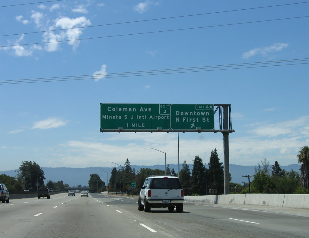 |
The next exit on Interstate 880 south is Exit 4A, North First Street south to downtown San Jose and north to the north end of California 87 (Guadalupe Parkway) and eventually a connection with California 237 (South Bay Freeway) near the south end of San Francisco Bay. The Guadalupe Light Rail Corridor flows First Street closely through northern San Jose. The next exit is Exit 3, Coleman Avenue to Norman Y. Mineta San Jose International Airport. Photo taken 08/05/05. |
 |
The next several interchanges serve the city of San Jose but also connect Interstate 880 with the city of Santa Clara, even though Interstate 880 does not enter that city. Santa Clara sits to the northwest of Interstate 880, and the ramps to the next four exits (Exit 3, Coleman Avenue to Norman Y. Mineta San Jose International Airport; Exit 2, California 82/The Alameda to Santa Clara; Exit 1D, Bascom Avenue; and Exit 1C, Stevens Creek Boulevard and West San Carlos Street) all connect to the city of Santa Clara. Photo taken 11/25/07. |
 |
A new right lane becomes exit only for Exit 3, Coleman Avenue. Photo taken 08/05/05. |
 |
Southbound Interstate 880 reaches Exit 3, Coleman Avenue to the Norman Y. Mineta San Jose International Airport. The airport's southern boundary is Interstate 880 and eastern boundary is California 87 (Guadalupe Parkway). The flight path into San Jose from the south passes close to downtown. Photo taken 08/05/05. |
 |
The next exit along Interstate 880 (Nimitz Freeway) south is Exit 2, California 82, El Camino Real to San Jose (southeast) and Santa Clara (northwest). El Camino Real is the original routing of U.S. 101 prior to its current routing along the Bayshore Freeway between San Jose and San Francisco. Photo taken 11/25/07. |
 |
This mileage sign along Interstate 880 south provides the distance to Exit 2, California 82/The Alameda to Santa Clara; Exit 1D, Bascom Avenue; and Exit 1C, Stevens Creek Boulevard and West San Carlos Street. The mileage sign says "Santa Clara" rather than "California 82." Use California 82 northwest to Santa Clara University, which is located in eastern Santa Clara only a half mile or so northwest of Interstate 880. Photo taken 11/25/07. |
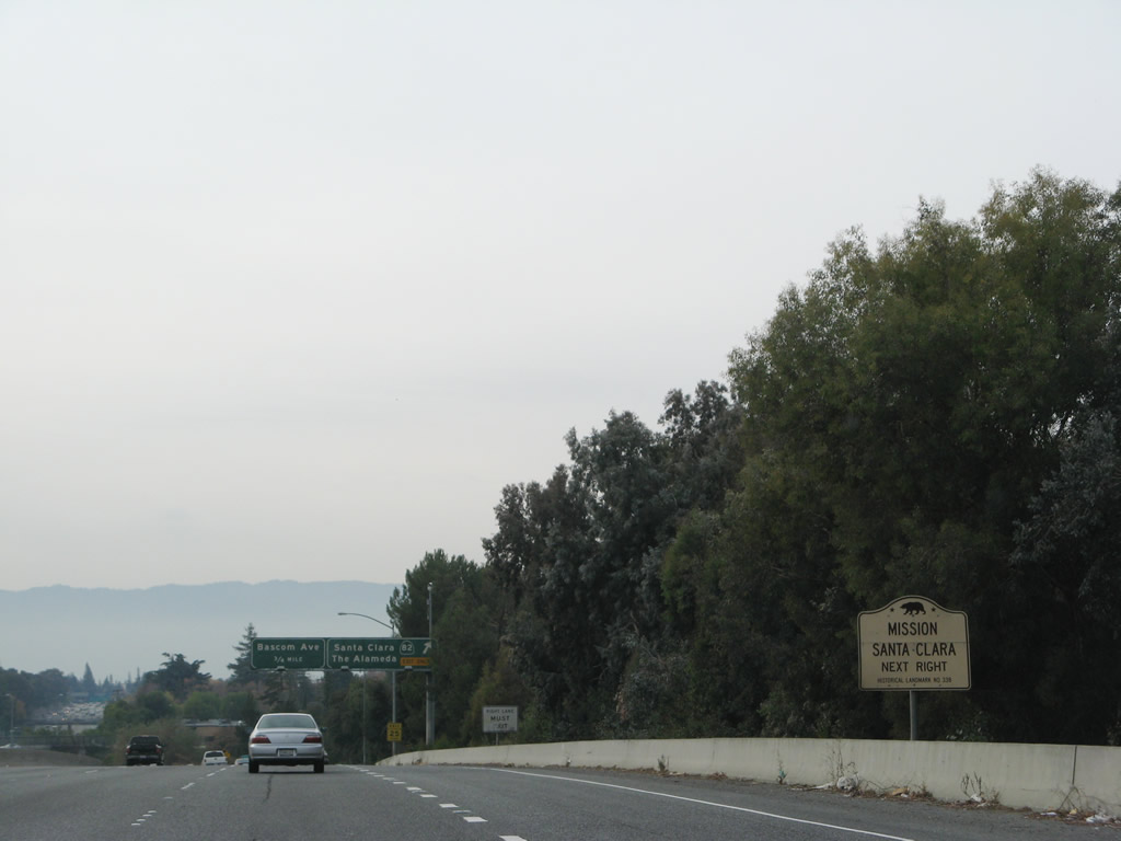 |
To Mission Santa Clara, use California 82 northwest toward Santa Clara University. The mission is located at the intersection of Lafayette Street and Homestead Road. Photo taken 11/25/07. |
 |
Southbound Interstate 880 reaches Exit 2, California 82, El Camino Real and The Alameda (Old U.S. 101). California 82 north leads to Santa Clara, the heart of Silicon Valley, located just west of Interstate 880, while California 82 south leads into downtown San Jose. Photo taken 11/25/07. |
 |
This reassurance shield for Interstate 880 south is posted after the on-ramp from California 82/The Alameda. Photo taken 11/25/07. |
 |
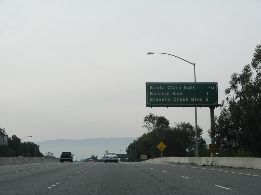
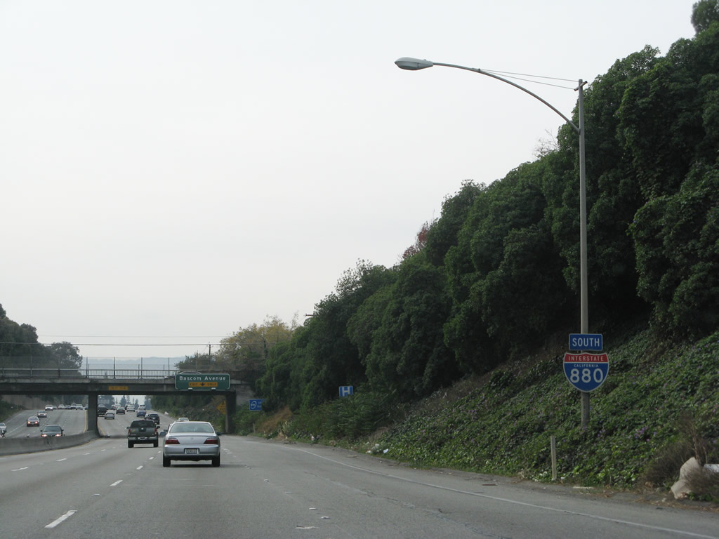
The next exit along Interstate 880 (Nimitz Freeway) south is Exit 1D, Bascom Avenue (right lane becomes exit only; the left three lanes continue south on Interstate 880 to California 17). The final exits along Interstate 880 south after Exit 1D are Exit 1C, Stevens Creek Boulevard/West San Carlos Street and Exits 1B-A, Interstate 280 and California 17 south to Santa Cruz. Photo taken 11/25/07. |
 |
Southbound Interstate 880 (Nimitz Freeway) reaches Exit 1D, Bascom Avenue. Photo taken 11/25/07. |
 |
This is the final southbound Interstate 880 reassurance shield, after the Bascom Avenue on-ramp. Photo taken 11/25/07. |
 |
The next exit along Interstate 880 south is Exit 1C, Stevens Creek Boulevard. Photo taken 11/25/07. |
 |
Southbound Interstate 880 reaches Exit 1C, Stevens Creek Boulevard. Exits 1A-B are for Interstate 280. Photo taken 11/25/07. |
 |
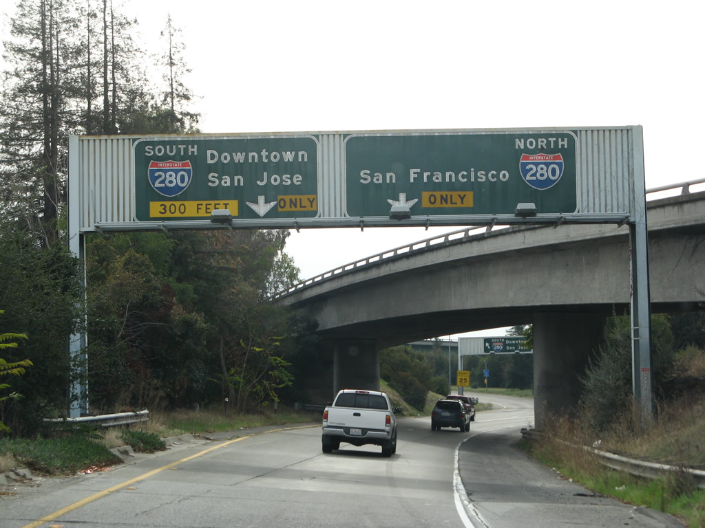
Immediately thereafter, Interstate 880 ends at the junction with Interstate 280 at Exit 1B. This is a major interchange. First, this interchange was the former southern terminus of Interstate 680 back when Interstate 680 was routed along today's Interstate 880 from California 262 (Mission Boulevard) south to Interstate 280. Second, this interchange marks the southern terminus of the Father Junipero Serra Freeway, which follows Interstate 280 north to San Francisco and marks the southern terminus of the Sinclair Freeway, which travels east and then north along Interstate 680, ending at the Santa Clara-Alameda County Line along Interstate 680. Finally, this interchange marks the current northern terminus of California 17, which continues south on the left three lanes. There is no end shield assembly for Interstate 880 south. Photo taken 11/25/07. |
 |
Now on the transition ramp from Interstate 880 south to Interstate 280, a set of old porcelain enamel signs advises that the single lane exit ramp will widen to two lanes. Stay left for Interstate 280 east (south) to downtown San Jose and stay right for Interstate 280/Serra Freeway north to San Francisco. Photo taken 11/25/07. |
 |
Shortly thereafter, the transition ramp splits, with the left lane connecting to Interstate 280 east (south) to downtown San Jose, Interstate 680 north, and U.S. 101 via asphalt lanes. The right lane (all concrete) connects to Interstate 280/Serra Freeway north to San Francisco. Photo taken 11/25/07. |
 |
View of the transition ramp from Interstate 880 south to Interstate 280 south. Photo taken 11/25/07. |

Page Updated February 21, 2008.
|
About Contact Glossary |
In The News Testimonials Interstate Guide |
Social Media:
 |
|
© 2000-23 AARoads.com | All Rights Reserved | Privacy Policy / Terms of Use
|
||