|
This mileage sign provides the distance to the next three exits along U.S. 101 south: Exit 400A, Rengstorff Avenue and Amphitheatre Parkway; Exit 399, Shoreline Boulevard; and Exit 398B, California 85 (Stevens Creek Freeway) south. Around this point, U.S. 101 leaves the city of Palo Alto and enters the city of Mountain View, which is home to 70,708 people as of the 2000 Census, sits at an elevation of 105 feet, and consists of 12.2 square miles. Photo taken 11/27/05. |
|
Southbound U.S. 101 reaches Exit 400A, Rengstorff Avenue and Amphitheatre Parkway. Photo taken 11/27/05. |
|
The next exit along U.S. 101 south is Exit 399, Shoreline Boulevard south to downtown Mountain View and north to the Shoreline Amphitheatre. Photo taken 11/27/05. |
|
Also coming up soon is the connection to California 85 (Stevens Creek Freeway) south to Sunnyvale, Cupertino, and Saratoga. California 85 parallels U.S. 101 and allows traffic two choices as a through route through the San Jose metropolitan area. Trucks are restricted on certain sections of California 85. Photo taken 11/27/05. |
|
This mileage sign provides the distance to the next three exits along U.S. 101 south: Exit 399, Shoreline Boulevard; Exit 398B, California 85 (Stevens Creek Freeway) south; and Exit 398A, Moffett Boulevard and NASA Parkway. Photo taken 11/27/05. |
|
Southbound U.S. 101 (Bayshore Freeway) reaches Exit 399, Shoreline Boulevard south to downtown Mountain View and north to the Shoreline Amphitheatre. The next exit is Exit 398B, California 85 (Stevens Creek Freeway) south to Cupertino. Photo taken 11/27/05. |
|
At the Exit 399 gore point, signage advises of a pending left exit for high occupancy vehicles (HOV) to California 85 south during commuting hours. Photo taken by Jeff Waller (10/13/07). |
|
This mileage sign provides the distance to the next three exits along U.S. 101 south: Exit 398B, California 85 (Stevens Creek Freeway) south; Exit 398A, Moffett Boulevard and NASA Parkway; and Exit 397, Ellis Street. Photo taken 11/27/05. |
|
Southbound U.S. 101 (Bayshore Freeway) reaches Exit 398B, California 85 south in Mountain View. The overhead sign was being replaced at the time this photo was taken. A new collector distributor lane between Exit 399 and Exit 398B allows traffic from Shoreline Boulevard to connect directly onto California 85 or U.S. 101 without having to merge across multiple lanes at the route split. The overpass for the c/d lanes can be seen crossing over the ramp from U.S. 101 south to California 85 south. Photo taken 11/27/05. |
|
After splitting with California 85, the next exit along U.S. 101 south is Exit 398A, Moffett Boulevard and NASA Parkway. Photo taken by Jeff Waller (10/13/07). |
|
The next several exits along U.S. 101 are Exit 397, Ellis Street and Moffett South Gate; Exit 396B, California 237 east to Alviso and Milpitas; Exit 396A, Mathilda Avenue to Sunnyvale; and Exits 395B-A, Fair Oaks Avenue. Photo taken by Jeff Waller (10/13/07). |
|
Southbound U.S. 101 reaches Exit 397, Ellis Street and Moffett South Gate. The next exit is Exit 396B, California 237 east to Alviso and Milpitas via the South Bay Freeway. Photo taken by Jeff Waller (10/13/07). |
|
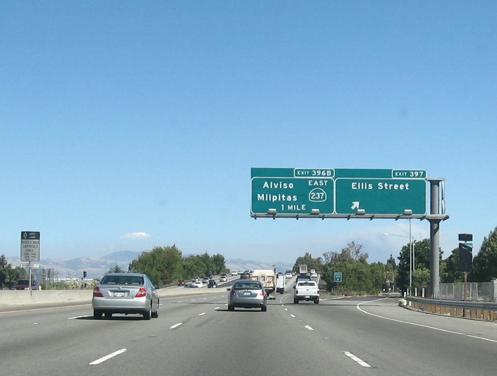
The next several exits along U.S. 101 are Exit 396B, California 237 east to Alviso and Milpitas; Exit 396A, Mathilda Avenue to Sunnyvale; Exits 395B-A, Fair Oaks Avenue; and Exit 394, Santa Clara County G-2 (Lawrence Expressway). Photo taken by Jeff Waller (10/13/07). |
|
Southbound U.S. 101 (Bayshore Freeway) reaches Exit 396B, California 237 east to Alviso and Milpitas. The next exit is Exit 396A, Mathilda Avenue to Sunnyvale. Photo taken by Jeff Waller (10/13/07). |
|
After the California 237 interchange, U.S. 101 (Bayshore Freeway) south approaches Exit 396A, Mathilda Avenue to Sunnyvale. The city of Sunnyvale, the "Heart of Silicon Valley," is situated between Los Altos and Santa Clara. The city is home to 131,760 people as of the 2000 Census and consists of 22.6 square miles. Sunnyvale incorporated in 1912 after being settled in the late 1800s. The next interchange along southbound is Exit 395B, Fair Oaks Avenue south and Exit 395A, Fair Oaks Avenue north. Photo taken 11/29/04. |
|
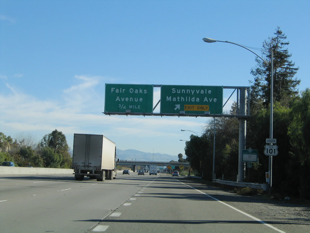
The next four exits along U.S. 101 south are Exit 395B, Fair Oaks Avenue south; Exit 395A, Fair Oaks Avenue north; Exit 394, Lawrence Expressway; and Exit 393, Great America Parkway and Bowers Avenue. Photo taken 11/29/04. |
|
Southbound U.S. 101 (Bayshore Freeway) reaches Exit 395B, Fair Oaks Avenue south. The next exit in this almost full cloverleaf interchange is Exit 395A, Fair Oaks Avenue north. Photo taken 11/29/04. |
|
Southbound U.S. 101 reaches Exit 395A, Fair Oaks Avenue north. The next exit is Exit 394, Santa Clara County G-2 (Lawrence Expressway) north to California 237 (South Bay Freeway) and south to the city of Santa Clara and eventually into western San Jose. The signed county route continues south along Quito Road, ending at California 9/Saratoga-Los Gatos Road. Photo taken 11/29/04. |
|
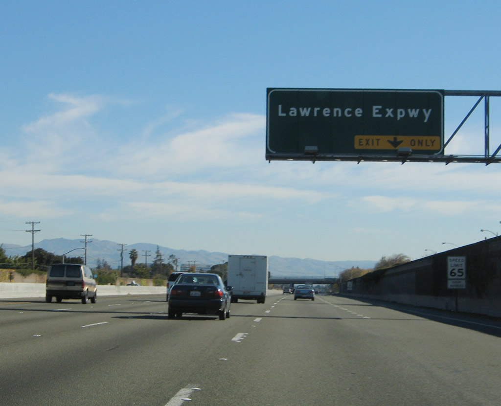
The right lane of U.S. 101 becomes exit only for Exit 394, Santa Clara County G-2 (Lawrence Expressway). Photo taken 11/29/04. |
|
A single Santa Clara County G-2 trailblazer is posted for the Lawrence Expressway off-ramp (Exit 394). The off-ramp is just beyond this trailblazer; the overhead sign that used to be here was missing at the time this photo was taken. Photo taken 11/29/04. |
|
The next two exits along U.S. 101 south are Exit 393, Great America Parkway and Bowers Avenue and Exit 392, Santa Clara County G-4 (San Tomas Expressway) south and Montague Expressway east. Around this point, U.S. 101 leaves Sunnyvale and enters the city of Santa Clara (population 102,361 and 18.38 square miles in area). The city was incorporated in 1852. The city has its own electric utility (Silicon Valley Power) and is the location of the Mission Santa Clara de Asis, which was founded in 1777 and marks the first settlement of this area. Photo taken 11/29/04. |
|
Southbound U.S. 101 (Bayshore Freeway) reaches Exit 393, Great America Parkway and Bowers Avenue. Use Great America Parkway north to Paramount's Great America, a theme park with roller coasters, thrill rides, and shows. To the south, Bowers Avenue leads into the heart of the city of Santa Clara, including Central Park and Santa Clara High School. The next exit along southbound is Exit 392, Santa Clara County G-4 (San Tomas Expressway) south and Montague Expressway east. Photo taken 11/29/04. |
|
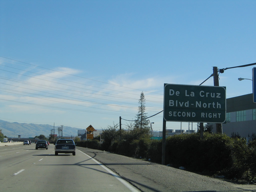
The next two exits along U.S. 101 south are Exit 392, Santa Clara County G-4 (San Tomas Expressway) south and Montague Expressway east and Exit 391B, De La Cruz Boulevard to Santa Clara. Photo taken 11/29/04. |
|
The right lane of U.S. 101 south becomes exit only for Exit 392, Santa Clara County G-4 (San Tomas Expressway) south and Montague Expressway east. The signed county route travels south from this interchange to California 17 Exit 23 through Santa Clara, western San Jose, and Campbell. At this interchange, the expressway turns east as the Montague Expressway, and may or may not retain its signed county route status. The Montague Expressway (County Route G-4) then travels east toward Interstate 680 Exit 6 in Milpitas. Much of the combined San Tomas Expressway and Montague Expressway corridor has a high occupancy vehicle lane for commuting hours. Photo taken 11/29/04. |
|
A trailblazer for Santa Clara County G-4 is posted beneath the Agnews Developmental Center auxiliary sign. The Agnews Developmental Center is a psychiatric and medical care facility that used was originally known as the "The Great Asylum for the Insane" when it was built in 1885.1 The center is located east of U.S. 101 via the Montague Expressway east to Zanker Road north. Redevelopment plans are being considered for this site, which is located along Coyote Creek near the San Jose-Milpitas city boundary. Photo taken 11/29/04. |
|
Southbound U.S. 101 (Bayshore Freeway) reaches Santa Clara County G-4 (Montague Expressway) east and Santa Clara County G-4 (San Tomas Expressway) south. Photo taken 11/29/04. |
|
The next three exits along U.S. 101 south are Exit 391B, De La Cruz Boulevard to Santa Clara; Exit 391A, Trimble Road; and Exit 390, California 87 (Guadalupe Parkway). Photo taken 11/29/04. |
|
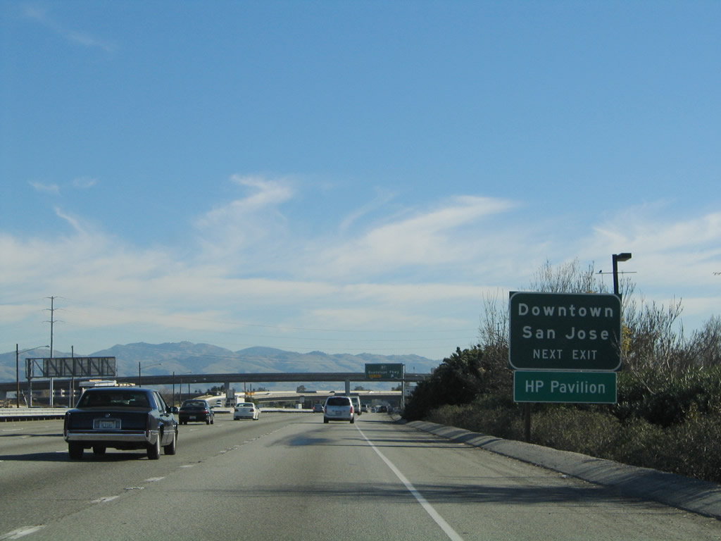
Use U.S. 101 south to Exit 390, California 87 (Guadalupe Parkway) south to the Norman Y. Mineta San Jose International Airport, downtown San Jose, and the HP Pavilion Arena. Photo taken 11/29/04. |
|
The next exit along U.S. 101 (Bayshore Freeway) is Exit 391B, De La Cruz Boulevard to Santa Clara. Photo taken 11/29/04. |
|
This interchange (Exits 391B-A) is a cloverleaf, so the first ramp connects to southbound De La Cruz Boulevard, and the second ramp loops onto De La Cruz Boulevard north and Trimble Road east. Photo taken 11/29/04. |
|
Use U.S. 101 south to Exit 390, California 87 (Guadalupe Parkway) south to the Norman Y. Mineta San Jose International Airport, including rental car return and long-term parking. Photo taken 11/29/04. |
|
An auxiliary sign advises of the connection to Exit 391A, Trimble Road east (and De La Cruz Boulevard north). Photo taken 11/29/04. |
|
Southbound U.S. 101 (Bayshore Freeway) reaches Exit 391B, De La Cruz Boulevard to Santa Clara. Photo taken 11/29/04. |
|
Immediately thereafter, southbound U.S. 101 (Bayshore Freeway) reaches Exit 391A, Trimble Road east and De La Cruz Boulevard north. At this point, U.S. 101 leaves the city of Santa Clara and enters the city of San Jose, which is home to 894,943 people as of the 2000 Census. Founded on November 29, 1777, and incorporated on March 27, 1850, San Jose is the third largest city in California (behind Los Angeles and San Diego). San Jose consists of 178.2 square miles and sits at an elevation of 85 feet. Rainfall in San Jose is much less than San Francisco due to its location at the south end of the San Francisco Bay and enclosure within mountains. The average annual precipitation is 14.4 inches. Photo taken 11/29/04. |
|
The next exit along southbound U.S. 101 (Bayshore Freeway) is Exit 390, California 87 (Guadalupe Parkway) south to the San Jose International Airport and downtown San Jose. The right lane becomes exit only for California 87 south. Photo taken 11/29/04. |
|
U.S. 101 skirts the northern edge of the San Jose International Airport runways between Exits 391B-A and 390. Soon the freeway crosses the Guadalupe River and meets California 87, which travels south as a freeway toward downtown San Jose. U.S. 101 remains east of downtown San Jose as it passes through this major city. Photo taken 11/29/04. |
|
Southbound U.S. 101 (Bayshore Freeway) reaches Exit 390, California 87 (Guadalupe Parkway) south to the Norman Y. Mineta San Jose International Airport and downtown San Jose. Photo taken 11/29/04. |
|
Tall flyover ramps carry California 87 to U.S. 101 (Bayshore Freeway) north and to First Street. Photo taken 11/29/04. |
|
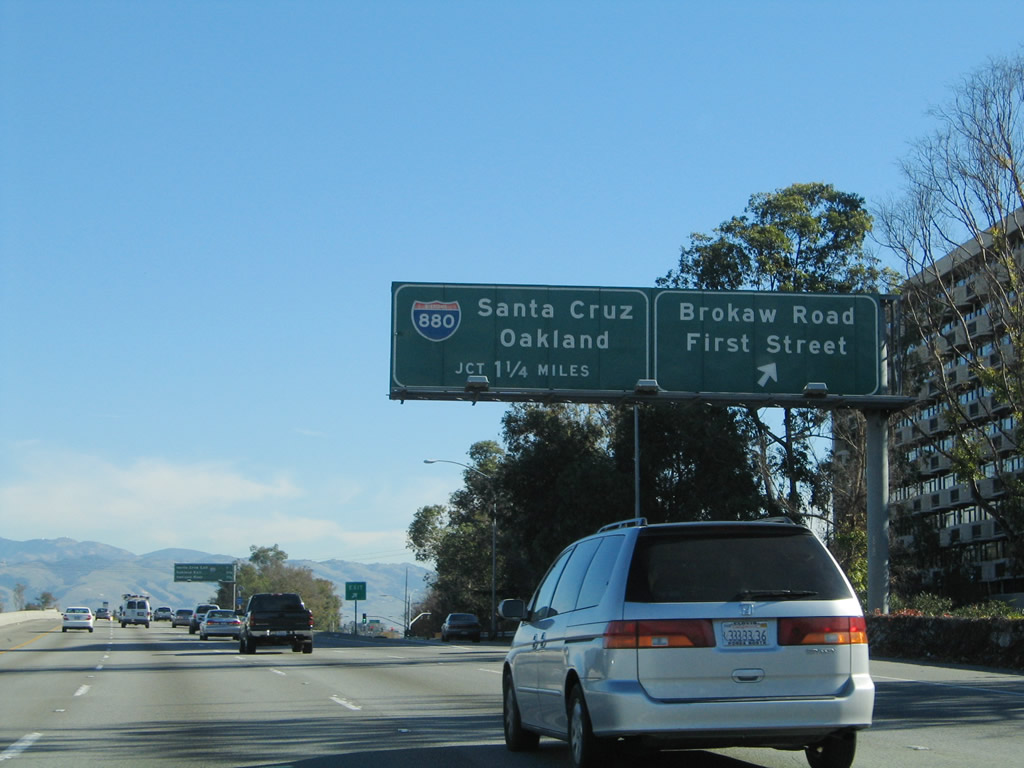
The next three exits along southbound U.S. 101 (Bayshore Freeway) are Exit 389, Brokaw Road/First Street; Exit 388C, Interstate 880 south to California 17 to Santa Cruz; and Exit 388B, Interstate 880 north to Oakland. Photo taken 11/29/04. |
|
Southbound U.S. 101 (Bayshore Freeway) reaches Exit 389, Brokaw Road/First Street and Old Bayshore Highway (frontage road). Upon exiting, turn right (west) on Brokaw Road/Airport Parkway to San Jose International Airport or turn left on Brokaw Road to First Street south toward the San Jose Civic Center (intersection of First Street and Hedding Street). Photo taken 11/29/04. |
|
The next three exits along southbound U.S. 101 (Bayshore Freeway) are Exit 388C, Interstate 880 south to California 17 to Santa Cruz; Exit 388B, Interstate 880 north to Oakland; and Exit 388A, Oakland Road and 13th Street. Photo taken 11/29/04. |
|
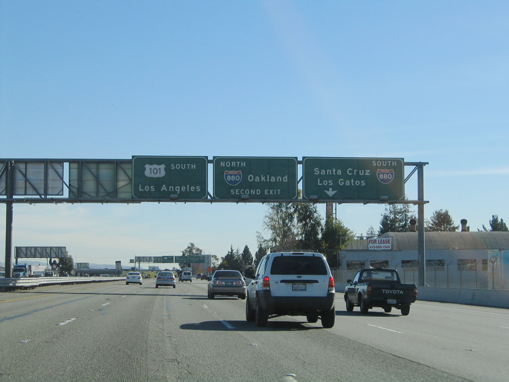
The next exit is the connection from U.S. 101 south to Interstate 880 south (Exit 388C). Interstate 880 is the Nimitz Freeway, which travels south to Interstate 280. At that interchange, Interstate 880 ends and California 17 continues south to Santa Cruz. The second right is Exit 388B, Interstate 880 (Nimitz Freeway) north to Oakland. Photo taken 11/29/04. |
|
Southbound U.S. 101 (Bayshore Freeway) reaches Exit 388C, Interstate 880 south to California 17 to Santa Cruz. The next ramp connects to Exit 388B, Interstate 880 north to Oakland. Photo taken 11/29/04. |
|
Immediately thereafter, U.S. 101 (Bayshore Freeway) south reaches Exit 388B, Interstate 880 (Nimitz Freeway) north to Oakland. Interstate 880 was known as California 17 until the mid-1980s, when the designation was changed so the Nimitz Freeway could be added to the Interstate Highway System. Photo taken 11/29/04. |
|
After the Interstate 880 interchange, U.S. 101 continues southeast toward its next exit, which connects the freeway to Old Oakland Road north and 13th Street south. Old Oakland Road and 13th Street are part of the former alignment of California 17, prior to the Nimitz Freeway being constructed. The Union Pacific Railroad crosses over the Bayshore Freeway here. Photo taken 11/29/04. |
|
Southbound U.S. 101 reaches Exit 388A, Old Oakland Road north and 13th Street south into downtown San Jose. Thirteenth Street passes close to the east side of San Jose State University and intersects Santa Clara Street a block west of San Jose Medical Center. Photo taken 11/29/04. |
|
The next exit along U.S. 101 south is Exit 386B, Julian Street west to downtown San Jose and McKee Road east to the Alum Rock neighborhood of San Jose. Photo taken 11/29/04. |
|
The next three exits along U.S. 101 south are Exit 386B, Julian Street west to downtown San Jose and McKee Road east; Exit 386A, California 130 (Alum Rock Avenue) and Santa Clara Street; and Exit 385B, Interstate 280 north to Downtown San Jose and Interstate 680 north to Sacramento. Photo taken 11/29/04. |
|
This porcelain enamel sign also advises of the pending junction with California 130 at Exit 386A, which serves Alum Rock Avenue east and Santa Clara Street west. The next exit is still Exit 386B to Julian Street and McKee Road. Photo taken 11/29/04. |
|
Southbound U.S. 101 (Bayshore Freeway) reaches Exit 386B, Julian Street west to downtown San Jose and McKee Road east. The next off-ramp is Exit 386A, California 130 (Alum Rock Avenue) and Santa Clara Street. Photo taken 11/29/04. |
|
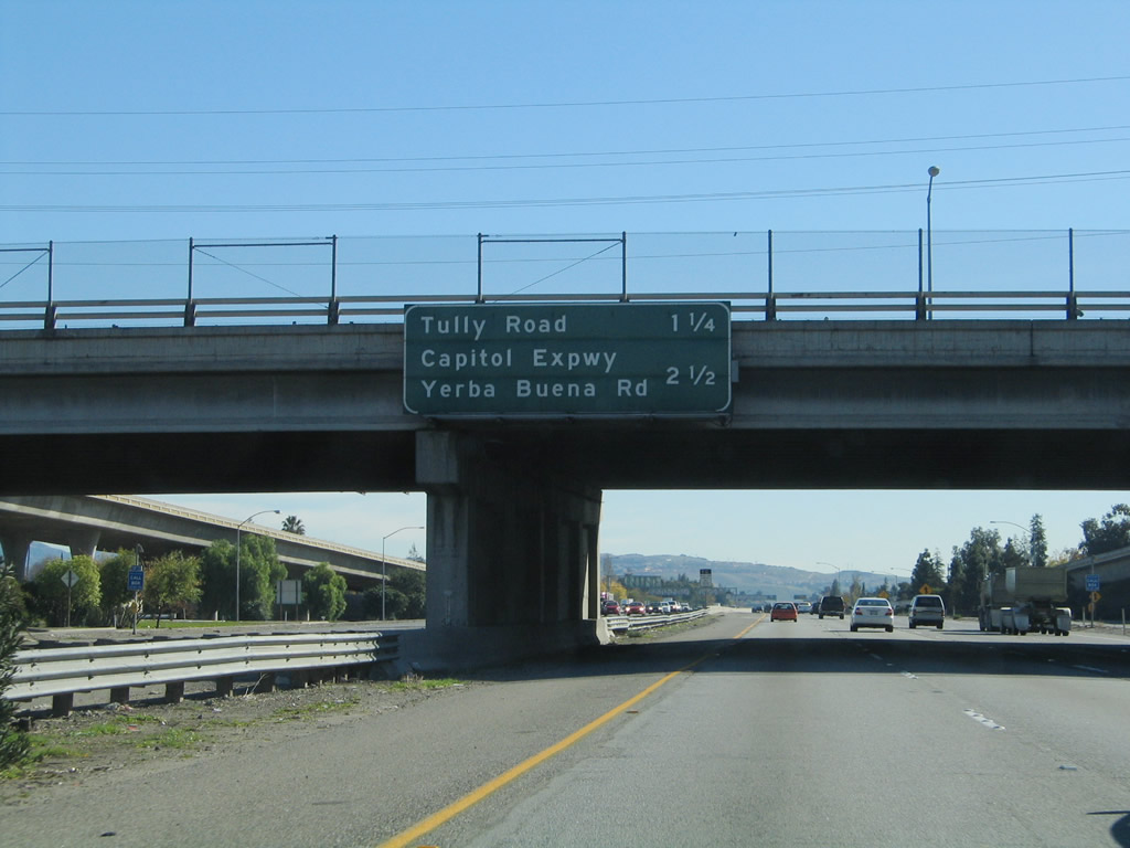
The next two exits along U.S. 101 south are Exit 383, Tully Road and Exit 382, Capitol Expressway and Yerba Buena Road. Photo taken 11/29/04. |
|
The right lane becomes exit only for Exit 383, Tully Road. Photo taken 11/29/04. |
|
Going forward for the rest of its length, the southbound control city for U.S. 101 will be Los Angeles. While northbound U.S. 101 has multiple control cities before San Francisco becomes the control city north of Santa Barbara, southbound U.S. 101 has only one control city. Note that the fastest route to Los Angeles is not a direct shot down U.S. 101; the shortest route involves using California 152 east and Interstate 5 south. Photo taken 11/29/04. |
|
Southbound U.S. 101 reaches Exit 383, Tully Road. Photo taken 11/29/04. |
|
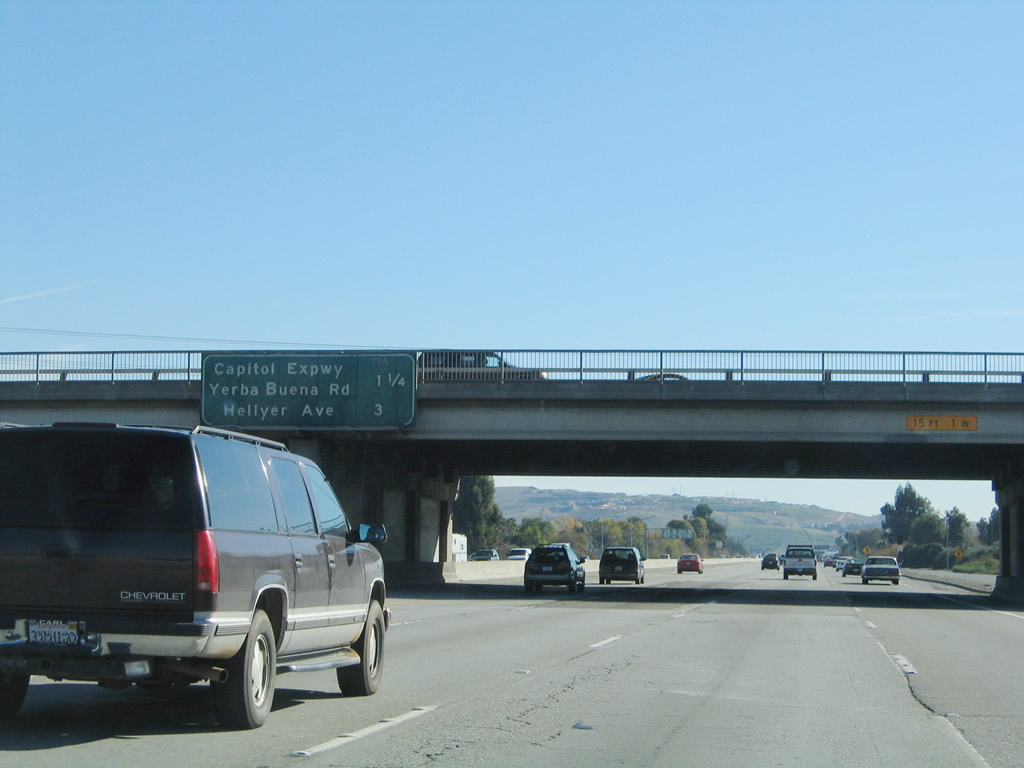
The next two exits along U.S. 101 south are Exit 382, Santa Clara County G-21 (Capitol Expressway) and Yerba Buena Road and Exit 380, Hellyer Avenue. Photo taken 11/29/04. |
|
The right two lanes of U.S. 101 south connects to Exit 382, Santa Clara County G-21 (Capitol Expressway). The exit only lane connects to Capitol Expressway west, and the other right lane connects to Capitol Avenue east and Yerba Buena Road. Photo taken 08/18/03. |
|
Southbound U.S. 101 reaches Exit 382, Santa Clara County G-21 (Capitol Expressway) and Yerba Buena Road. The next exit is Exit 380, Hellyer Avenue. Photo taken 11/29/04. |
|
The next three exits along U.S. 101 south are Exit 380, Hellyer Avenue; Exit 378, California 82; and Exit 377B, California 85 (West Valley Freeway) north. Photo taken 11/29/04. |
|
Use Hellyer Avenue to the Coyote Creek County Park. Photo taken 11/29/04. |
|
Southbound U.S. 101 reaches Exit 380, Hellyer Avenue. Photo taken 11/29/04. |
|
The next three exits along U.S. 101 south are Exit 378, California 82; Exit 377B, California 85 (West Valley Freeway) north; and Exit 377A, Bernal Avenue. Photo taken 11/29/04. |
|
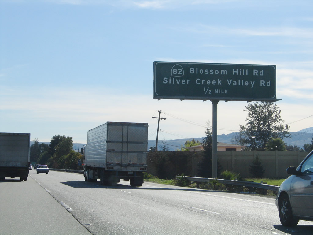
Exit 378 directly connects with Blossom Hill Road west and Silver Creek Valley Road east. Use Blossom Hill Road west to California 82 (Monterey Highway) north and to Santa Clara County G-10 (Blossom Hill Road) west. Silver Valley Road provides access to residential areas to the northeast. Photo taken 11/29/04. |
|
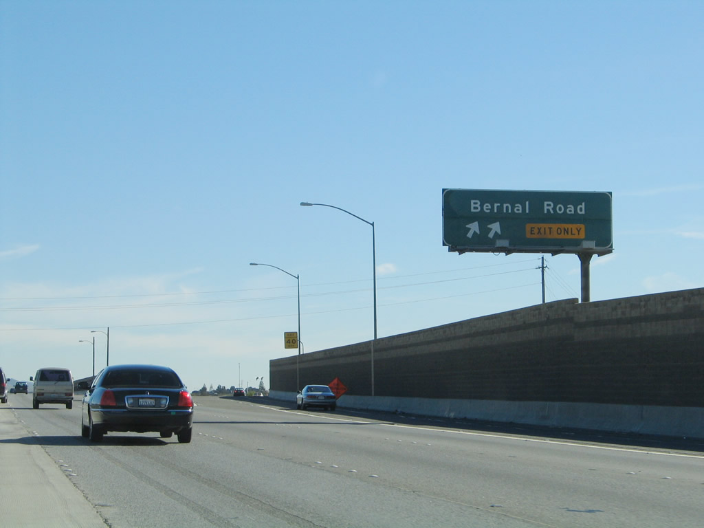
Southbound U.S. 101 reaches Exit 378, Blossom Hill Road west to California 82 (Monterey Highway) north and Santa Clara County G-10 (Blossom Hill Road) west. This exit also connects to Monterey Highway south and to Silver Valley Road east. This exit marks the southern terminus of California 82, which follows the original alignment of U.S. 101 through San Jose and the East Bay communities before ending at Interstate 280 in San Francisco. It also might be the northern terminus of a long stretch of U.S. 101 Business, which closely follows U.S. 101 from San Jose south to Morgan Hill and Gilroy. The Bayshore Freeway ends here, and the South Valley Freeway begins. Photo taken 11/29/04. |
|
The next two exits along southbound U.S. 101 (South Valley Freeway) are Exit 377B, California 85 (West Valley Freeway) north and Exit 377A, Silicon Valley Road/Bernal Road. California 85 is a relatively new freeway that extends northwest from here around the San Jose metropolitan area, and it rejoins U.S. 101 near its interchange with California 237. No trucks are allowed on the newer section of California 85 from U.S. 101 north to the Interstate 280 interchange. Photo taken 11/29/04. |
|
The right lane becomes exit only for Exit 377B, California 85 (West Valley Freeway) north to Cupertino and Mountain View. The second right is for Exit 377A, Bernal Road. Photo taken 11/29/04. |
|
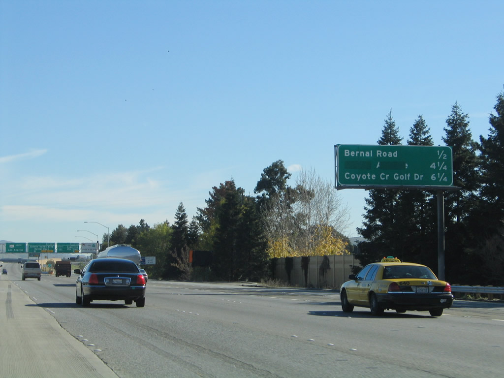
This mileage sign along U.S. 101 (South Valley Freeway) south provides the distance to the next three exits (after Exit 377B, California 85): Exit 377A, Silicon Valley Road/Bernal Road; Exit 373, Bailey Avenue; and Exit 371, Coyote Creek Golf Drive. Photo taken 11/29/04. |
|
This mileage sign along U.S. 101 (South Valley Freeway) south provides the distance to the next three exits (after Exit 377B, California 85): Exit 377A, Silicon Valley Road/Bernal Road; Exit 373, Bailey Avenue; and Exit 371, Coyote Creek Golf Drive. Photo taken 11/29/04. |
|
Southbound U.S. 101 (South Valley Freeway) reaches Exit 377B, California 85 north to Cupertino and Mountain View. The next exit is Exit 377A, Bernal Road. Photo taken 11/29/04. |
|
Immediately thereafter, U.S. 101 reaches Exit 377A, Silicon Valley Road/Bernal Road. There are no exits for the next four miles (until Bailey Avenue, Exit 373). Photo taken 11/29/04. |
|
This mileage sign along U.S. 101 (South Valley Freeway) south provides the distance to the next three exits: Exit 373, Bailey Avenue; Exit 371, Coyote Creek Golf Drive; and Exit 367, Cochrane Road. This sign was replaced in 2005 to include the distance to the Bailey Avenue interchange, which was not finished until 2005. Photo taken 11/29/04. |
|
Another mileage sign along U.S. 101 south provides the distance to Morgan Hill (12 miles), Gilroy (20 miles), and Los Angeles (382 miles). Massive power lines coming from the east interconnect the Path 15 north-south power lines with generating facilities and power customers in the San Francisco Bay Area. The 500kV power line leads from Path 15 to the Moss Landing Power Generating Station northwest of Salinas. Photo taken 11/29/04. |
|
The 500kV substation is massive, and it dominates the view on U.S. 101 south for a good distance. Several 230kV power lines connect with the 500kV power line at this station. Photo taken 11/29/04. |
|
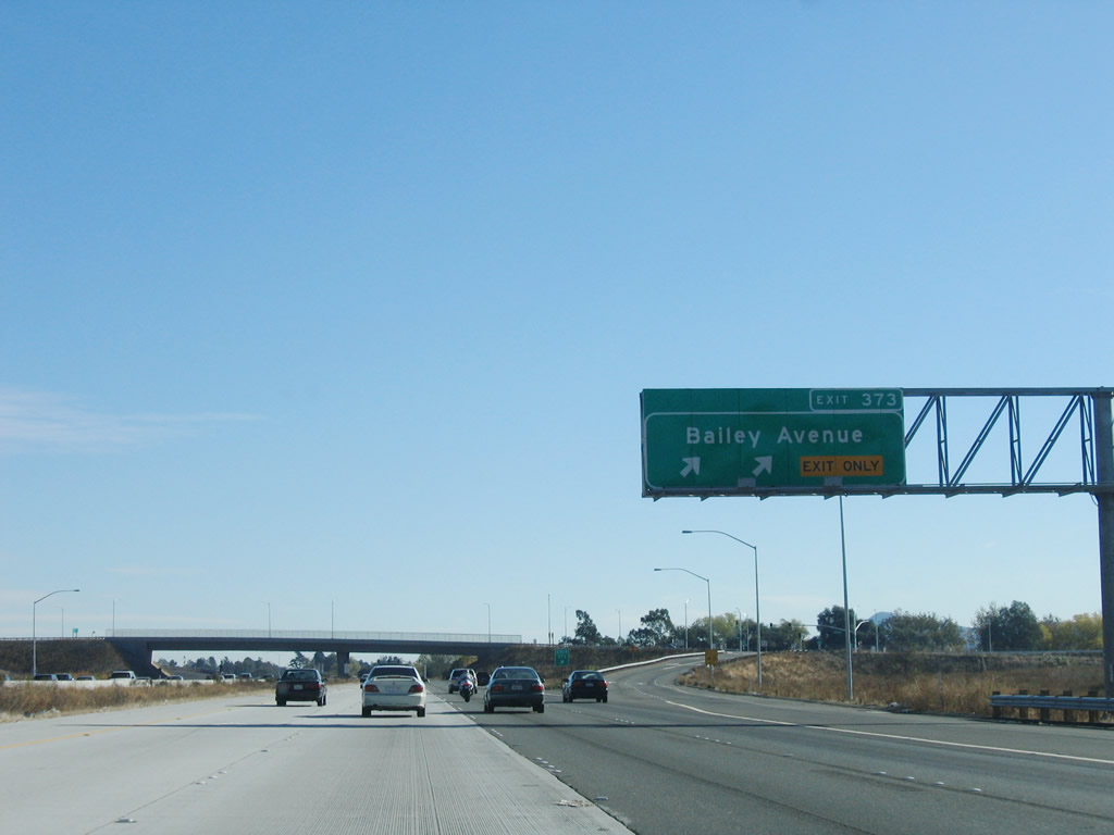
The next exit along U.S. 101 south is Exit 373, Bailey Avenue. This interchange opened in 2005 to accommodate new housing development in southern San Jose. Despite the rural feel of this area, we are still in the city of San Jose. Photo taken 11/27/05. |
|
Southbound U.S. 101 reaches Exit 373, Bailey Avenue. Photo taken 11/27/05. |
|
The next exit along U.S. 101 south is Exit 371, Coyote Creek Golf Drive. Old U.S. 101 (Monterey Highway/El Camino Real), which may or may not be U.S. 101 Business, closely parallels the freeway on the west side. Photo taken 11/29/04. |
|
The next two exits along U.S. 101 south are Exit 371, Coyote Creek Golf Drive and Exit 367, Cochrane Road. Photo taken 11/29/04. |
|
Southbound U.S. 101 reaches Exit 371, Coyote Creek Golf Drive. The two left lanes (concrete) were added in the early 2000s; prior to that, this area was notoriously backed up as a four-lane freeway. Photo taken 11/29/04. |
|
The next exit along U.S. 101 south is Exit 367, Cochrane Road to U.S. 101 Business (Monterey Highway) and Morgan Hill. Photo taken 11/29/04. |
|
This mileage sign provides the distance to the next three exits along U.S. 101 south: Exit 367, Cochrane Road to U.S. 101 Business (Monterey Highway); Exit 366, East Dunne Avenue to downtown Morgan Hill; and Exit 365, Tennant Avenue. Photo taken 11/29/04. |
|
The right lane of U.S. 101 becomes exit only for Exit 367, Cochrane Road. In addition, the left lane, which has been a high occupancy vehicle lane during commuting hours, becomes a general use lane. Photo taken 11/27/05. |
|
Southbound U.S. 101 reaches Exit 367, Cochrane Road. Photo taken 11/29/04. |
|
This mileage sign provides the distance to the next three exits along U.S. 101 south: Exit 366, East Dunne Avenue to downtown Morgan Hill; Exit 365, Tennant Avenue; and Exit 362, San Martin Avenue. Photo taken 11/29/04. |
|
The next exit along U.S. 101 south is Exit 366, East Dunne Avenue west to the city of Morgan Hill. U.S. 101 departs the city of San Jose and enters Morgan Hill, which was incorporated on November 10, 1906, and is home to 33,556 people as of the 2000 Census. Photo taken 11/29/04. |
|
Southbound U.S. 101 reaches Exit 366, East Dunne Avenue west to Morgan Hill. Photo taken 11/29/04. |
|
The next exit along U.S. 101 south is Exit 365, Tennant Avenue. Photo taken 11/29/04. |
|
This mileage sign provides the distance to the next three exits along U.S. 101 south: Exit 365, Tennant Avenue; Exit 362, San Martin Avenue; and Exit 360, Masten Avenue. Photo taken 11/29/04. |
|
Southbound U.S. 101 reaches Exit 365, Tennant Avenue. Photo taken 11/29/04. |
|
This mileage sign provides the distance to the next three exits along U.S. 101 south: Exit 362, San Martin Avenue; Exit 360, Masten Avenue; and Exit 357, California 152 (Leavesley Road) west. Photo taken 11/29/04. |
|
The next exit along U.S. 101 south is Exit 362, San Martin Avenue. Photo taken 11/29/04. |
|
Southbound U.S. 101 reaches Exit 362, San Martin Avenue. Photo taken 11/27/05. |
|
This mileage sign provides the distance to the next three exits along U.S. 101 south: Exit 360, Masten Avenue; Exit 357, California 152 (Leavesley Road) west; and Exit 357, California 152 (Pacheco Pass Road) east and 10th Street. Photo taken 11/29/04. |
|
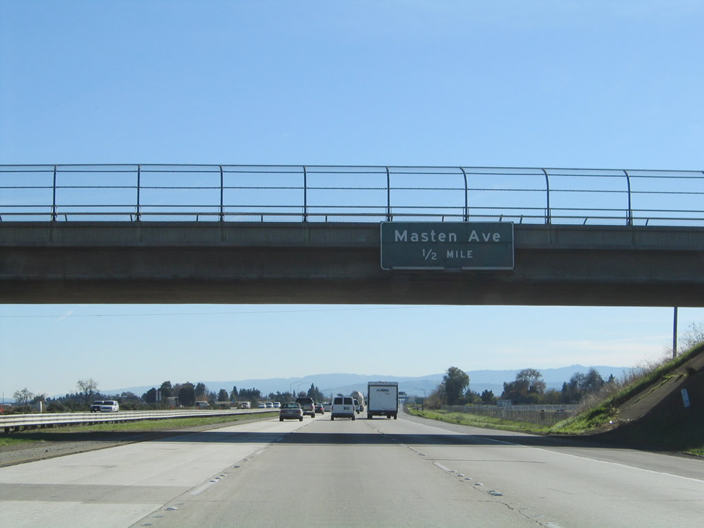
The next exit along U.S. 101 south is Exit 360, Masten Avenue. Photo taken 11/29/04. |
|
Southbound U.S. 101 reaches Exit 360, Masten Avenue. Photo taken 11/29/04. |
|
The next exit along southbound is a weigh station, followed by Exit 357, California 152 (Leavesley Road) west and Santa Clara County G-9 (Leavesley Road) east, which is the first Gilroy interchange. Photo taken 11/29/04. |
|
This mileage sign provides the distance to the next three exits along U.S. 101 south: Exit 357, California 152 (Leavesley Road) west; Exit 356, California 152 (Pacheco Pass Road) east and 10th Street; and Exit 355, U.S. 101 Business (Monterey Street) north. Photo taken 11/29/04. |
|
A trailblazer for the Juan Bautista de Anza auto tour route and Santa Clara County G-9 east are posted prior to Exit 357. To U.S. 101 Business south and downtown Gilroy, follow California 152 west. U.S. 101 enters the city of Gilroy, which is the last city within Santa Clara County along the U.S. 101 corridor. Gilroy had a population of 41,464 and is known as the "Garlic Capital of the World." The city was incorporated on March 12, 1870, and it consists of 15.9 square miles. Photo taken 11/29/04. |
|
Use California 152 (Leavesley Road) west to Watsonville via Hecker Pass. In addition, westbound California 152 connects with Santa Clara County G-8 (Uvas Road) north, which eventually becomes the Almaden Expressway in greater San Jose. Photo taken 11/29/04. |
|
Southbound U.S. 101 reaches Exit 357, California 152 west to Watsonville and downtown Gilroy. California 152 connects with California 1 and the coast at Watsonville. California 152 east merges with southbound U.S. 101 briefly before splitting at Exit 356. Photo taken 08/18/03. |
|
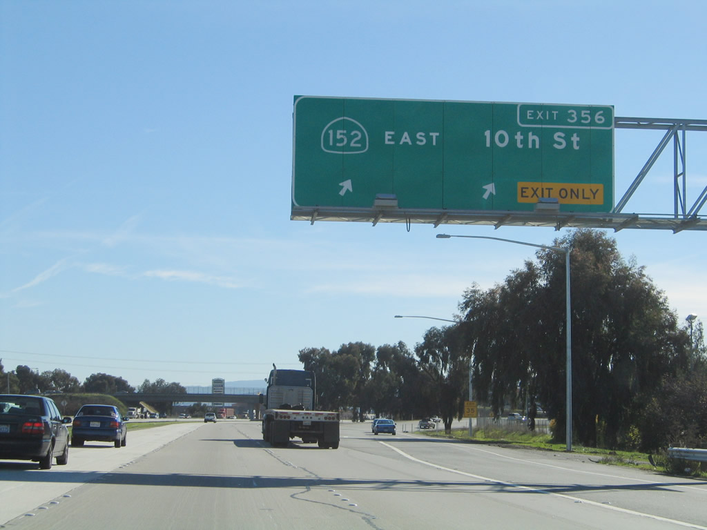
The next exit along southbound is Exit 356, California 152 (Pacheco Pass Road) east to the Central Valley, with connections to Interstate 5 and California 99 via the city of Los Banos. Photo taken 11/27/05. |
|
This mileage sign provides the distance to the next three exits along U.S. 101 south: Exit 356, California 152 (Pacheco Pass Road) east and 10th Street; Exit 355, U.S. 101 Business (Monterey Street) north; and Exit 353, California 25 south to Hollister. California 152 east and U.S. 101 south remain merged for approximately a mile between Exits 357 and 356. Photo taken 11/27/05. |
|
The right lane becomes exit only for Exit 356, California 152 (Pacheco Pass Road) east and 10th Street. Traffic tends to back up a bit here because the connection between U.S. 101 and California 152 east requires movements through multiple traffic signals. A proposed realignment of California 152 to allow for a faster connection from U.S. 101 has not been constructed primarily due to funding considerations. Photo taken 11/27/05. |
|
Southbound U.S. 101 reaches Exit 356, California 152 (Pacheco Pass Road) east and 10th Street west. Use California 152 east to Interstate 5 near Los Banos. Since California 152 is mostly a multi-lane divided expressway (not freeway) between U.S. 101 and Interstate 5, it provides an alternate route for traffic from San Jose and the South Bay to reach Interstate 5 without having to use Interstate 580 and the Altamont Pass. Photo taken 11/27/05. |
|
The next exit along U.S. 101 south is Exit 355, U.S. 101 Business (Monterey Street) north. This is the third and final Gilroy interchange. Photo taken 11/27/05. |
|
This mileage sign provides the distance to the next two exits along U.S. 101 south: Exit 355, U.S. 101 Business (Monterey Street) north to Gilroy, and Exit 353, California 25 south to Hollister and Bloomfield Road. Photo taken 11/29/04. |
|
Southbound U.S. 101 reaches Exit 355, U.S. 101 Business (Monterey Street) north to Gilroy. Photo taken 11/29/04. |
|
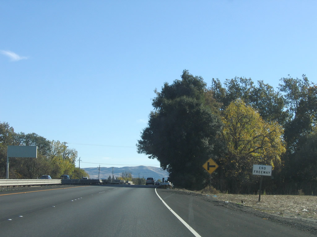
After Exit 355, the freeway temporarily ends. U.S. 101 reduces to two lanes in the southbound direction and will revert to expressway standards for about six miles. Photo taken 11/27/05. |
|
As the concrete lanes end, asphalt lanes continue the highway south. The direction of the concrete lanes suggest a future intent to build a new alignment of freeway from this point south, but it is unclear how that would proceed. Photo taken 11/27/05. |
|
A small end freeway sign is posted shortly thereafter. The next "exit" is an intersection with Mesa Road west. Photo taken 11/27/05. |
|
After Mesa Road, the next right turn is with Castro Valley Road west to Gavilan College. Photo taken 11/27/05. |
|
Expressway sections of U.S. 101 in Central California typically have intersections, and they occasionally have driveways (yes, that is a mailbox). The next intersection is with Castro Valley Road west to Santa Teresa Boulevard north. A right turn lane pocket is provided. Photo taken 11/27/05. |
|
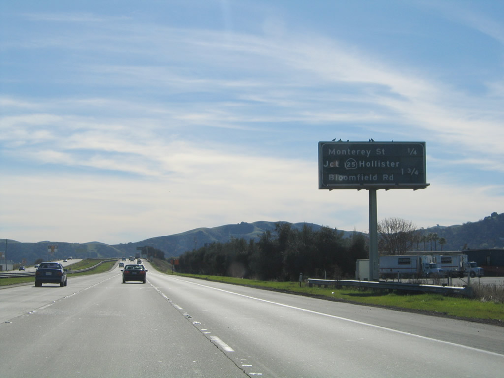
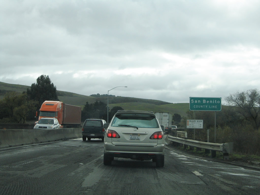
The next exit along U.S. 101 south is Exit 353, California 25 south to Hollister and Santa Clara County G-7/Bloomfield Avenue east to California 152. California 25 is a mostly two-lane state highway that travels south through Hollister (the seat of San Benito County) and connects to the east entrance of Pinnacles National Monument (via California 146). Photo taken 11/29/04. |
|
Southbound U.S. 101 reaches Exit 353, California 25 south. This unusual interchange features a normal off-ramp from southbound, but the northbound exit to California 25 is very sharp with minimal deceleration space. This interchange marks the northern terminus of California 25. Photo taken 11/29/04. |
Page Updated February 12, 2008.