|
| The first southbound San Diego County S-6 reassurance shield is posted at the exit from the Palomar Observatory parking lot. 11/11/10, 06/16/06 |
|
| The county road initially travels northward before turning southward to Upper French Valley and Fry Creek Campground. 06/16/06 |
|
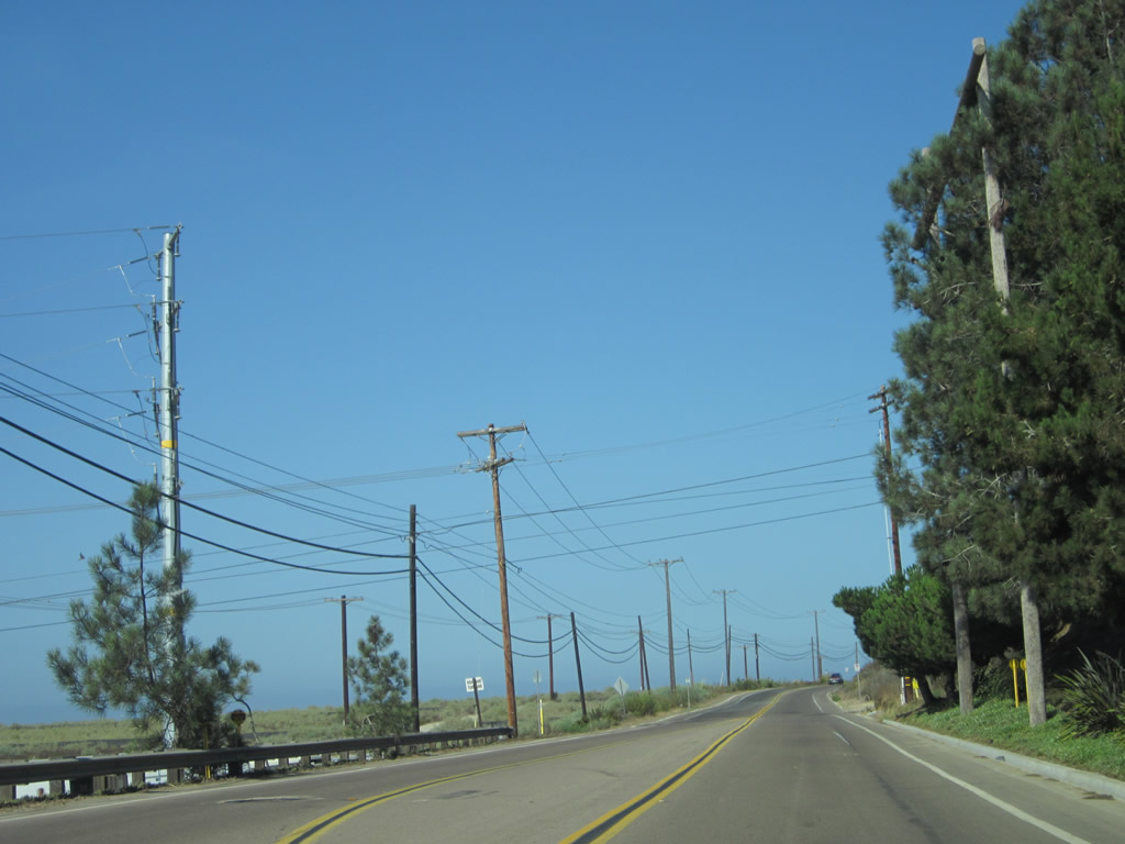
| Lightly traveled CR S-6 en route to the unincorporated community of Palomar Mountain. 06/16/06 |
|
| Fall colors abound on top of Palomar Mountain in this scene along County Road S-6 south. 11/11/10 |
|
| CR S-6 passes towering trees along the drive between the observatory and a small commercial strip near the intersection with CR S-7. 06/16/06 |
|
| Much of the drive along San Diego County S-6 on Palomar Mountain in tree-lined and rustic. 11/11/10 |
|
| CR S-6 emerges from the forest canopy in the community of Palomar Mountain, as it connects with San Diego County S-7. CR S-7 (State Park Road) spurs west to Palomar Mountain State Park. 06/16/06 |
|
| The intersection of South Grade Road (CR S-6) and State Park Road (CR S-7) is home to a small commercial plaza providing the lone services for Palomar Mountain. 06/16/06 |
|
| County Roads S-6 and S-7 briefly combine, then separate with CR S-6 winding southwest from Frazier Point toward Pauma Valley and Valley Center. CR S-7 lines East Grade Road to Dyche Valley Will Valley and Lake Henshaw. 11/11/10 |
|
| Westbound San Diego County S-6 follows Valley Parkway through Downtown Escondido, while the county road east lines Second Avenue two blocks to the south. A commercial strip along Grand Avenue occupies the space between the two directions. Here, CR S-6 meets Escondido Boulevard by the California Center for the Arts - Escondido. 04/23/05 |
|
| A San Diego County S-6 reassurance marker appears along westbound Valley Parkway just before Centre City Parkway (Business Loop I-15). 04/23/05 |
|
| Business Loop i-15 north connects Downtown Escondido with SR 78 (Ronald Packard Freeway). The state route heads west to Vista, San Marcos, and Oceanside. 04/23/05 |
|
| Business Loop I-15 (Centre City Parkway) heads south to Rancho Bernardo, Rancho Peñasquitos, and points south in the city of San Diego. Centre City Parkway north combines with Interstate 15 north ahead of Fallbrook, Temecula, and Riverside. 04/23/05 |
|
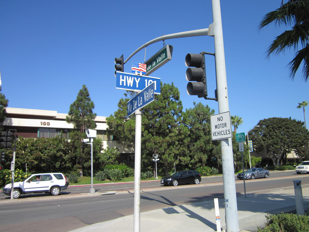
| Westbound S-6 (Via de la Valle) after El Camino Real and the Santa Fe Downs residential development. Overhead, several San Diego Gas & Electric power lines (including a double circuit 230kV line) pass high above Via de la Valle. CR S-6 proceeds west toward its rendezvous with Interstate 5 and the Del Mar Racetrack, one of the most popular and well-known venues in San Diego County. 09/01/12 |
|
| Following the San Dieguito River from near Del Dios / Rancho Santa Fe southwest to Del Mar and Solana Beach, County Road S-6 stays on the northern edge of the San Dieguito Lagoon. This lagoon extends inland to east of Interstate 5. As a result, there is limited development along the south side of Via de la Valle along this stretch until Flower Hill Promenade. 09/01/12 |
|
| Via de la Valle changes into a commercial boulevard as it enters Flower Hill Promenade. The road widens to four lanes, and congestion frequently occurs at the upcoming traffic signals with San Andreas Drive and Del Mar Shopping Center. 09/01/12 |
|
| A parclo B2 interchange joins San Diego County S-6 (Via de la Valle) with Interstate 5 (San Diego Freeway). The northbound on-ramp leads motorists to the northern San Diego County cities Encinitas, Carlsbad, Oceanside. 09/01/12 |
|
| Freeway entrance assemblies at the northbound on-ramp from Via de la Valle westbound. I-5 is a well traveled road, paralleling old U.S. 101 north along the coast toward Orange County. Once reaching Downtown Los Angeles, Interstate 5 continues north along the old U.S. 99 corridor through the Tehachapi Mountains toward the Central Valley. 09/01/12 |
|
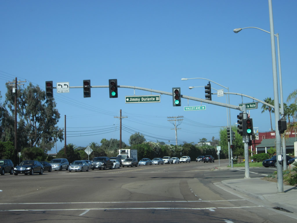
| Passing under the freeway, Via de la Valle approaches the loop ramp for I-5 south and Jimmy Durante Boulevard to Del Mar Racetrack. Note that during events at the Del Mar Racetrack, the center turn lane can function as an additional westbound lane to help move traffic to Jimmy Durante Boulevard and the various parking lots located adjacent to the fairgrounds. The overhead sign displays "when lane" which conveys that the center lane is optional during fairground events. 09/01/12 |
|
| Interstate 5 continues south from Via de la Valle toward La Jolla, Pacific Beach, and Downtown in San Diego. Via de la Valle west to Coast Highway 101 was formerly a part of Business Loop I-5. 09/01/12 |
|
| Beyond the exchange with I-5, the left two lanes of Via de la Valle west connect to Jimmy Durante Boulevard southwest to the main entrance to Del Mar Racetrack. The racetrack and fairgrounds are home to many events throughout the year including the marquee events San Diego County Fair in June and early July and Del Mar Thoroughbred Club, which features horse racing in late July, August, and September. The venue opened in 1937, and the Thoroughbred Club' slogan for its horse racing season is "Where The Turf Meets The Surf." 09/01/12 |
|
| Jimmy Durante Boulevard winds southwest by Del Mar Racetrack to Downtown Del Mar. Surrounded by the city of San Diego to the south, Del Mar incorporated on July 15, 1959 and is 1.71 square miles wide. 09/01/12 |
|
| Via de la Valle west extends along the Del Mar and Solana Beach city line to Historic U.S. 101 (Camino Del Mar). Adjacent Solana Beach consists of 3.52 square miles, and was incorporated on July 1, 1986. 09/01/12 |
|
| Via de la Valle narrows to one westbound lane for its final distance to Coast Highway 101 and Camino Del Mar. 09/01/12 |
|
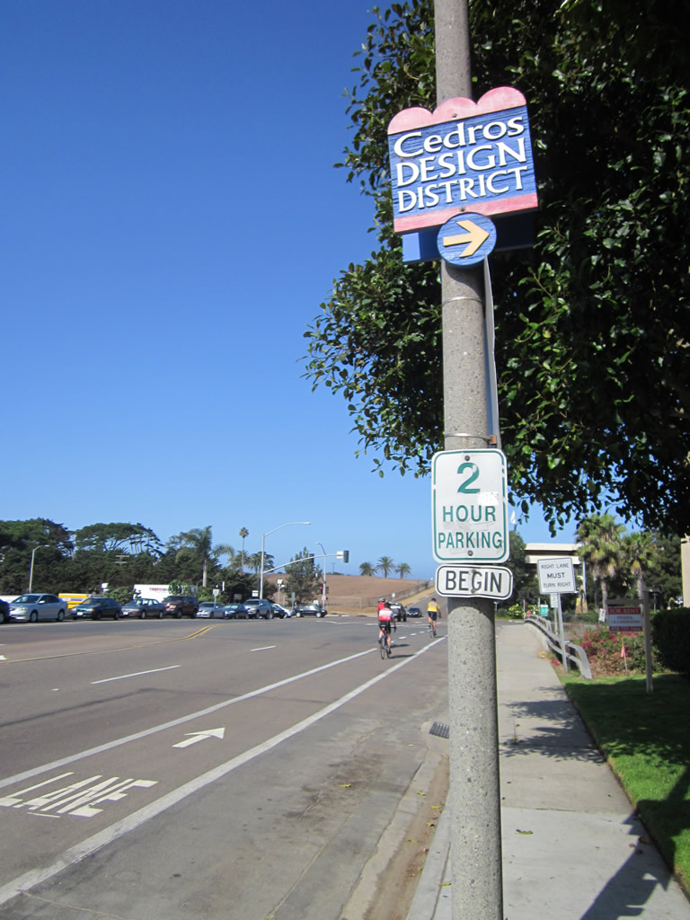
| Prior to the Coaster Railroad underpass and the signalized intersection with CR S-21 (Coast Highway 101 / Camino Del Mar), Via de la Valle west intersects Cedros Avenue north. Cedros Avenue leads into the Cedros Design District, located in Downtown Solana Beach. A wide variety of art houses, restaurants, antique stores and entertainment venues are located along Cedros Avenue closer to Lomas Santa Fe Drive (San Diego County S-8). 09/01/12 |
|
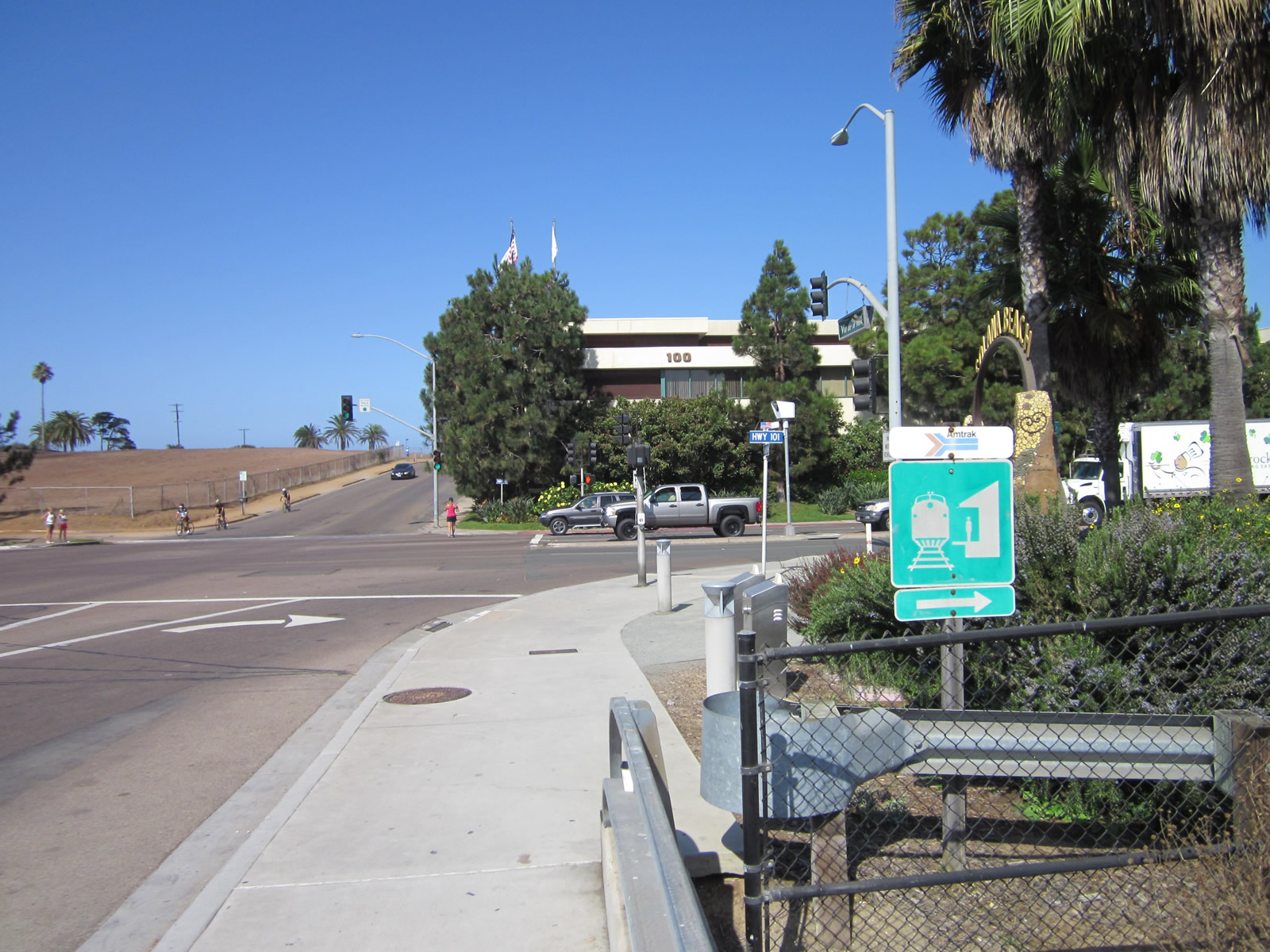
| Looking north from Via de la Valle at the Coaster commuter rail line, which connects San Diego and Oceanside. Amtrak and freight rail also use this line. 09/01/12 |
|
| San Diego County S-6 concludes at an unmarked intersection with Camino Del Mar south to Del Mar and Highway 101 north to Solana Beach. Historic U.S. 101 doubles as unsigned San Diego County S-21 north to Solana Beach, Encinitas, Carlsbad, and Oceanside. 09/01/12 |
Page Updated 08-14-2017.