The city of Roseburg began as a claim purchased by New Yorker Aaron Rose. Rose traveled west over the Applegate Trail and platted a town site in 1850. The settlement began as stop along the Oregon-California Trail, officially garnering its name of Roseburg in 1857. Incorporation followed in 1872, coinciding with the arrival of the O&C Railroad and growth of the local agricultural industry. Expansion of the city continued through the 20th century, with Roseburg established as an economic center for the timber industry. 2.8 million acres of commercial forest land surround Roseburg throughout Douglas County.
|
| Interstate 5 heads through northeastern Josephine County toward Sexton Mountain Pass. 03/31/05 |
|
| Monument Drive, the old alignment of U.S. 99 north from Exit 61, converges with I-5 at Exit 66, ahead of Sexton Mountain Pass. Oxyoke Road stems north from nearby to the community of Hugo. Hugo, formerly named "Gravel Pit", was established as a flag station along the Oregon and California Railroad in 1883. A post office commenced operations at the site in 1895. Hugo derives its name from Hugo Garbers, a long time area farmer. The area was known for cherry harvests through the 20th century. 03/31/05 |
|
| Northbound at the diamond interchange (Exit 66) with Monument Drive. Jumpoff Joe Creek Road extends east from I-5. A local trapping party camped along Jumpoff Joe Creek in 1828 when member Joe Mcloughlin arrived after dark and fell from a cliff nearby. Mcloughlin sustained severe injuries from the fall. 03/31/05 |
|
| Continuing northbound on Interstate 5 at the Monument Drive over crossing. A distance sign lists the distances to Sunny Valley, the succeeding exit, Roseburg, and Portland. 03/31/05 |
|
| Interstate 5 climbs to 1,960 feet to Sexton Mountain Pass. Travelers are advised to slow to 50 mph to navigate the curved portions of the freeway through this stretch. 03/31/05 |
|
| Interstate 5 lowers from Sexton Summit to Sunny Valley and Exit 71 with Lariet Drive west and Sunny Valley Loop east. Despite its surroundings by mountains, the sun always shines on the meadows and creeks below, hence the name Sunny Valley. The site is home to the Grave Creek Covered Bridge, the only such span visible along the entire length of Interstate 5, and the Applegate Wagon Trail Museum. 03/31/05 |
|
| Leaving Sunny Valley, Interstate 5 climbs to Smith Hill Summit (elevation 1,730 feet). The freeway reaches unincorporated Wolf Creek at a split diamond interchange (Exit 76) with Old U.S. 99 and Coyote Creek Road. Founded in 1872 by Henry Smith, Wolf Creek grew as a lumber and supply center for the Wolf Creek and Coyote Creek mines. The Oregon and California Railroad built a station at the settlement. 03/31/05 |
|
| Coyote Creek Road spurs east from alongside I-5 to King Mountain (el. 5,265 feet). Old U.S. 99 joins Interstate 5 with Front Street / Lower Wolf Creek Road at Wolf Creek. Points of interests for Exit 76 include the historic Wolf Creek Inn and Wolf Creek Park. 03/31/05 |
|
| Old U.S. 99 returns to the freeway from a wye interchange (Exit 78) at Speaker Road. Progessing north from there, I-5 rises to 1,830 feet through Stage Road Pass. Glendale Valley and Junction Roads meet the freeway east of Glendale at Exit 80. 03/31/05 |
|
| Interstate 5 enters Douglas County ahead of the folded diamond interchange (Exit 80) with Junction Road north and Glendale Valley Road west. Glendale Valley Road heads west 2.5 miles to Sether Avenue in the city of Glendale. Junction Road ventures north to County Road 12 (Old Pacific Highway) at Glendale Junction. 03/31/05 |
|
| Interstate 5 curves eastward from the Glendale area to Quines Creek and Azalea in southern Douglas County. The second rest area along I-5 north in Oregon was located between Exits 80 and 83. 03/31/05 |
|
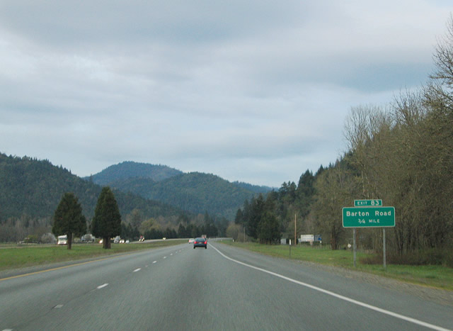
| 0.75 miles west of the diamond interchange (Exit 83) with Barton Road on I-5 north. Barton Road stems south from Old U.S. 99 (County Road 12) three miles to Murphy Road and King Mountain. 03/31/05 |
|
| Exit 83 leaves Interstate 5 northbound for Barton Road. Ranchero Road begins as an northbound side frontage road from Barton Road east to Quines Creek Road (Exit 83). 03/31/05 |
|
| Interstate 5 north and the parallel Ranchero Road travel to within one mile of Quines Creek Road. Quines Creek Road travels south from the Old Pacific Highway to Ranchero and Eakin Roads at Interstate 5, and from there southeast to Murphy Road and King Mountain. 03/31/05 |
|
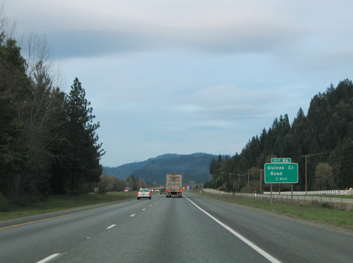
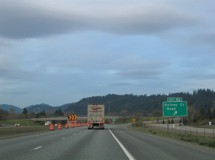
| Northbound at the diamond interchange (Exit 86) with Quines Creek Road and the settlement of Quines Creek. 03/31/05 |
|
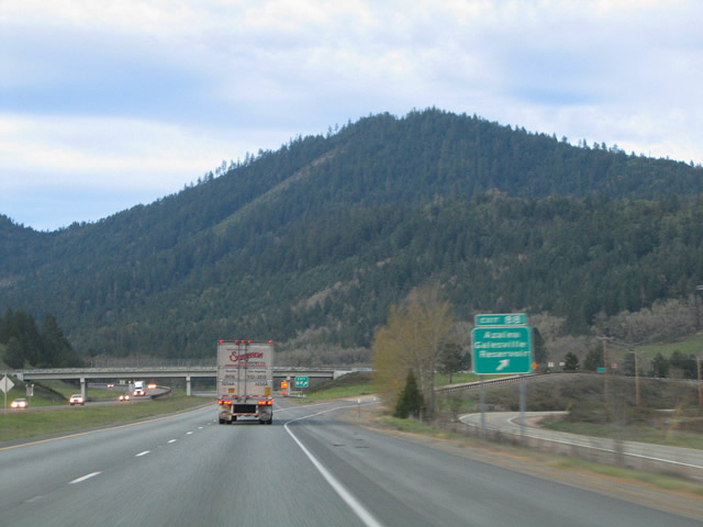
| Old U.S. 99 (Old Pacific Highway) reunites with Interstate 5 again at Upper Cow Creek Road, Mobley Drive, and Creek Road (Exit 88). Upper Cow Creek Road heads east from Exit 88 to the settlement of Azalea and Galesville Reservoir. Creek Road and Mobley Drive comprise local frontage roads for the freeway. 03/31/05 |
|
| Interstate 5 resumes a northern trajectory between Azalea and Canyonville. The freeway elevates to 2,015 feet at Canyon Creek Pass ahead of a diamond interchange (Exit 95) with Mexia and Richie Roads. 03/31/05 |
|
| OR 99 formerly looped east from I-5 through Canyonville along 5th Street and Main Street through Downtown between Exits 98 and 99. The state highway connected with OR 227 (3rd Street / Tiller Trail Highway) east. OR 227 originally traveled 8 miles east to Days Creek and 49 miles to OR 62 at Trail. The route was rescinded in 2003 to just 11.26 miles between OR 62 at Trail and the Douglas County line. 03/31/05 |
|
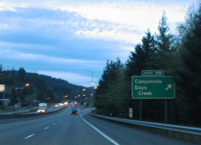
| A split diamond interchange (Exit 98) joins I-5 with 5th Street (old OR 99) and Canyonville-Riddle Road west five miles to the city of Riddle. Canyonville began as a stop along the historic Scott-Applegate Trail and later as a ferry crossing settlement named Kenyonville. Jesse Roberts platted the town site in 1858 and named it Canyonville after the nearby Canyon Creek Canyon. The city lies at 747 feet above sea level, around 1,300 feet below the Canyon Creek headwaters. 03/31/05 |
|
| OR 99 (Main Street) returned to I-5 from Downtown Canyonville at Exit 99. Old U.S. 99 continues to parallel the freeway along Tiller Trail Highway west to Yokum Road (Exit 101). 03/31/05 |
|
| Exit 99 departs Interstate 5 northbound onto the adjacent Main Street at north Canyonville. Main Street intersects Gazley Bridge Road and Creekside Road at the freeway interchange. Old U.S. 99 continues the frontage road north to Charles V. Stanton Park. 03/31/05 |
|
| Old U.S. 99 ties into Interstate 5 again at a folded diamond interchange (Exit 101) with Yokum Road. Yokum Road stems 2.8 miles west from I-5 to 1st Avenue in Riddle. 03/31/05 |
|
| Interstate 5 makes a pronounced northern turn from the South Umpqua River into a diamond interchange (Exit 102) with Gazely Road. Gazely Road ventures east from Lawson Bar Road and I-5 to Surprise Valley. 03/31/05 |
|
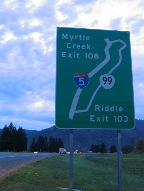
| A diagrammatic guide sign outlines the former OR 99 loop into Tri City and Myrtle Creek between Exits 103 and 108. The state route formerly emerged from I-5 at a parclo interchange with Pruner Road along Myrtle Highway northeast through Tri City. Riddle Bypass Road ties into the forthcoming exchange from the west. 03/31/05 |
|
| The ensuing off-ramp from I-5 north is at the diamond interchange (Exit 106) with Weaver Road. Running alongside the Southern Pacific Railroad. Weaver Road stems north from Riddle Bypass and Pruner Roads to Weaver and Interstate 5. Aviation Drive leads southwest from Exit 106 to Myrtle Creek Municipal Airport (16S). 03/31/05 |
|
| Interstate 5 parallels the South Umpqua River closely between the airport and city of Myrtle Creek. Former OR 99 (Main Street) returns to the freeway at a trumpet interchange (Exit 108) west of Downtown Myrtle Creek. Founded in 1893, Myrtle Creek is home to around 3,500 residents. Interstate 5 remains alongside the South Umpqua River north to Exit 113. 03/31/05 |
|
| Interstate 5 northbound next meets Boomer Hill Road at a diamond interchange (Exit 110). Boomer Hill Road ends at Booth Ranch Road and Exit 110 alongside the South Umpqua River. 03/31/05 |
|
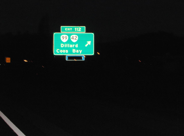
| OR 99 separates with I-5 from a folded diamond interchange (Exit 112) with Dillard Highway. OR 99 follows Dillard Highway northwest 8.3 miles through Dillard to OR 42 (Coos Bay-Roseburg Highway) at Winston. OR 99 provides a cutoff for OR 42 (Coos Bay-Roseburg Highway). OR 42 travels west from Winston 71 miles across the Coast Ranges to U.S. 101 south of Coos Bay. 03/31/05 |
|
| Exit 113 comprises a diamond interchange between Interstate 5 and Clarks Branch Road. Clarks Branch Road travels east from Dole Road into the nearby mountains. Dole Road parallels the freeway northward to Roberts Mountain Road and Round Prairie. 03/31/05 |
|
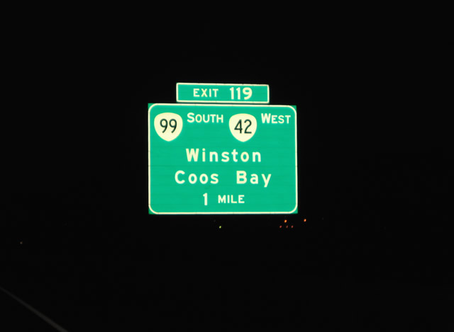
| One mile south of Exit 119 for OR 42 west and OR 99 south on I-5 northbound. OR 42 follows most of the Coos Bay-Roseburg Highway west from Exit 119 to U.S. 101. The Coos Bay-Roseburg Highway follows old U.S. 99 south from Downtown Roseburg to overlay OR 42 just west of Exit 119. OR 42 west & 99 south overlap 3.3 miles west to Winston. OR 99 northbound rejoins I-5 between Exits 119 and 120. 03/31/05 |
|
| The succeeding three interchanges join Interstate 5 north with the city of Roseburg. Old U.S. 99 (Coos Bay-Roseburg Highway) meets the freeway at a folded diamond interchange (Exit 120) with Carnes Road. OR 99 departs I-5 there toward Downtown Roseburg. Interstate 5 crosses the Umpqua River north of Exit 120 and stays west of the river to Exit 124. OR 99 meanwhile travels alongside the river to the one way couplet of Stephens Street (north) and Pine Street (south). 03/31/05 |
|
| Exit 121 departs Interstate 5 northbound onto an adjacent frontage road ahead of McLain Avenue outside Roseburg. McLain Avenue links the freeway with Roseburg Landfill Road and Chewaucan Lane to the west. 03/31/05 |
|
| The diamond interchange (Exit 123) with Portland Avenue serves the adjacent Douglas County Fairgrounds and Umpqua Park between Interstate 5 and the Umpqua river. Heritage Way and Corvallis Avenue tie into the exchangef rom the west. 03/31/05 |
|
| Interstate 5 approaches the Roseburg city limits one mile south of the parclo interchange (Exit 124) with OR 138 (Harvard Boulevard). OR 138 provides a direct route into Downtown Roseburg along a one way couplet of Oak Street (east) and Washington Street (west). 03/31/05 |
|
| Exit 124 leaves Interstate 5 northbound for OR 138 (Harvard Boulevard) east in Roseburg. Harvard Avenue comprises an arterial route between Lookingglass Road and Madrone Street in west Roseburg. OR 138 merges with OR 99 along Stephens Street north out of Downtown to Diamond Lake Boulevard. An Oregon Scenic Byway, OR 138 continues 71 miles east from Roseburg to Diamond Lake. 03/31/05 |
|
| OR 138 west combines with I-5 north for a 12 mile overlap to Sutherlin. The ensuing exit lies north of the Umpqua River with Garden Valley Boulevard in north Roseburg. The six-ramp parclo interchange (Exit 125) lies midway between OR 99 (Stephens Street) and Stewart Parkway. 04/01/05 |
|
| Continuing through north Roseburg to Exit 127 (Edenbower Boulevard) on I-5 north & OR 138 west. Edenbower Boulevard arcs north of Roseburg Regional Airport (RBG) between Broad Street and OR 99 (Stephens Street). Broad Street parallels Interstate 5 southward to Stewart Parkway. 04/01/05 |
Page Updated 11-11-2005.