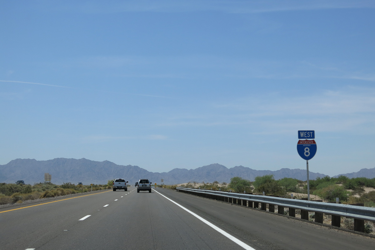
Interstate 8 replaced U.S. 80 through Telegraph Pass, which enables the freeway to cross the Gila Mountains. Telegraph Pass is unusual for the "wrong-way alignment," where the westbound lanes cross over the eastbound lanes, leading to a reversal of the lane order. This was done due to terrain issues through the pass. The present day eastbound lanes follow the later (1948) alignment of U.S. 80, while the westbound lanes cut across the original 1928 alignment of U.S. 80.
|
| Paralleling Wellton Canal to the north, Interstate 8 proceeds across western Mohawk Valley. 04/07/13 |
|
| Interstate 8 shifts north from the Mohawk Valley toward Dome Valley and the succeeding exit at Lugurta in nine miles. 04/07/13 |
|
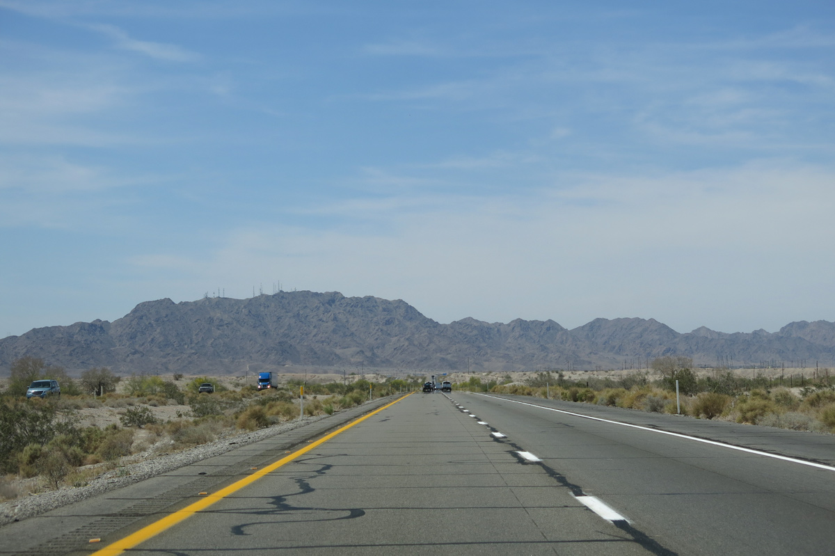
| Interstate 8 eventually crosses the distant Gila Mountains into the Colorado River valley at the Yuma Desert. 04/07/13 |
|
| Interstate 8 spans Ligurta Wash south of the Lugurta Foothills community ahead of mile marker 24. 05/31/21 |
|
| Crossing over Wellton Mohawk Canal again, Interstate 8 proceeds one mile west to the Ligurta Parking Area. 05/31/21 |
|
| The Ligurta Parking Area precedes mile marker 23. 04/07/13 |
|
| Interstate 8 crosses Red Top Wash south of a power substation. 04/07/13 |
|
| Interstate 8 reaches the parking area west of Red Top Wash. 04/07/13 |
|
| The speed limit reduces to 65 miles per hour just ahead of the trumpet interchange at Exit 21 with Old U.S. 80. The speed limit remains at 65 until past the first exit in California for Winterhaven. 05/31/21 |
|
| Old U.S. 80 ties into Interstate 8 at Exit 21 from Dome Valley. The 1928 and 1948 alignments of U.S. 80 followed Interstate 8 over the Gila Mountains. 05/31/21 |
|
| Ascending into the Gila Mountains, Interstate 8 westbound makes a sweeping curve south from the exchange at Exit 21. 05/31/21 |
|
| Entering Telegraph Pass, the westbound roadway shifts south across the eastbound roadway due to grade differences. 05/31/21 |
|
| Passing over the eastbound roadway along Interstate 8 west. Another instance in the Interstate system where two roadways switch sides like this so as to not exceed a 6% grade maximum is along I-5 north of Los Angeles en route to the Central Valley. 05/31/21 |
|
| The succeeding exit lies beyond the Gila Mountains at the Yuma suburb of Fortuna Foothills. The city center of Yuma is 19 miles to the west. 05/31/21 |
|
| The westbound roadway along Interstate 8 through Telegraph Pass utilizes the 1948 realignment of U.S. 80 while the eastbound roadway follows the 1928 alignment of U.S. 80. 05/31/21 |
|
| Interstate 8 west crosses over the eastbound roadway again just beyond mile marker 9. 05/31/21 |
|
| Descending into the South Gila Valley and Yuma Desert, the street grid of Fortuna Foothills spreads into view. This rapidly growing area is very popular with snowbirds. 05/31/21, 04/07/13 |
|
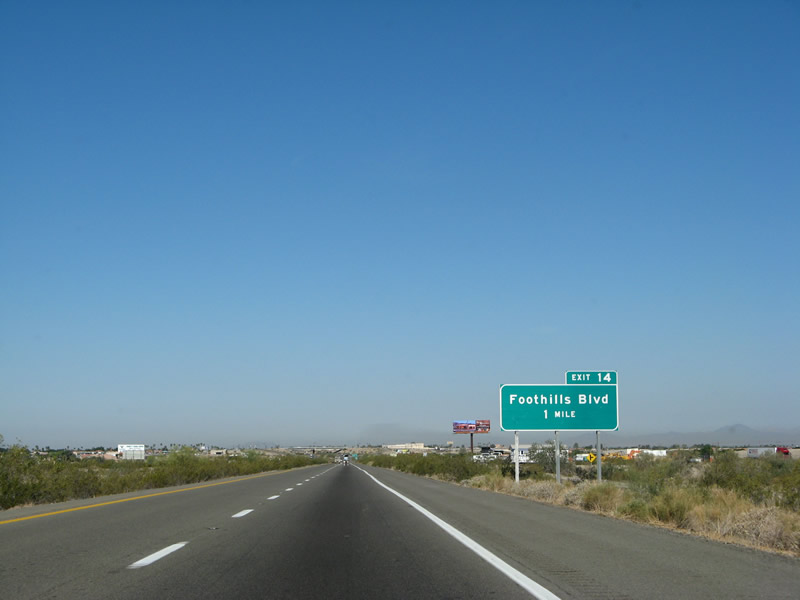
| Interstate 8 flattens out beyond the Gila Mountains, lowering from near 700 feet in elevation to 334 feet at the diamond interchange (Exit 14) with Foothills Boulevard. 03/19/07 |
|
| Foothills Boulevard constitutes a five lane commercial boulevard south through the community of Fortuna Foothills. The suburban community was home to nearly 30,000 by the 2020 Census. 05/31/21 |
|
| Interstate 8 advances 1.75 miles west from Foothills Boulevard to a diamond interchange (Exit 12) with Fortuna Road. 03/19/07 |
|
| Residential subdivisions lines the north side of Interstate 8 west beyond Foothills Boulevard. Yuma is growing to where development covers everything between the Gila Mountains and the Colorado River. 04/07/13 |
|
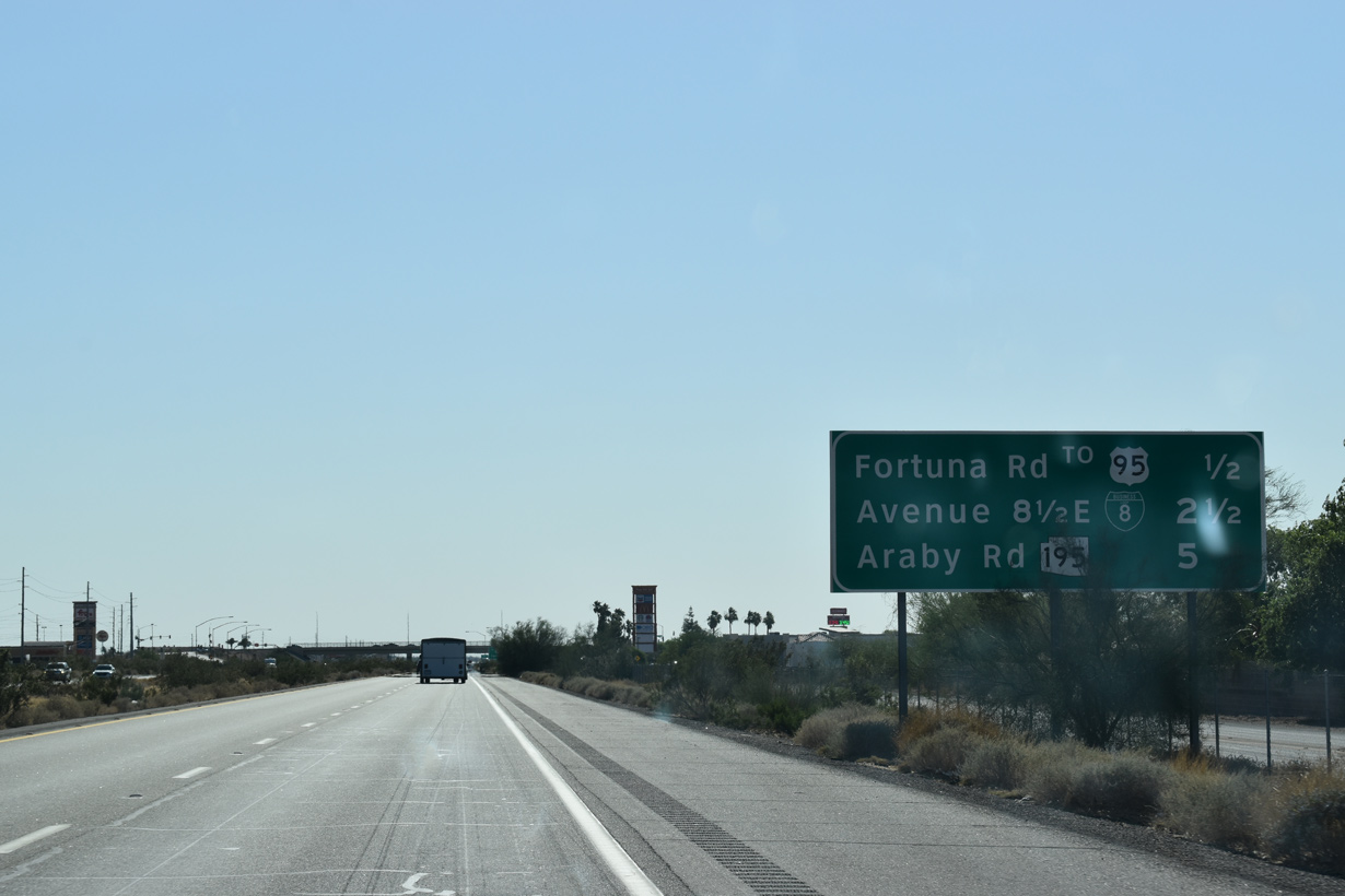
| Fortuna Road provides a direct route from Exit 12 north two miles to U.S. 95 for Quartzsite, Blythe and Las Vegas, Nevada. 04/07/13 |
|
| Fortuna Road north to U.S. 95 leads to the U.S. Army Yuma Proving Grounds, old McPhaul Suspension Bridge and Kofa Mountains National Wildlife Refuge. 04/07/13 |
|
| U.S. 95 meets Interstate 8 directly at Exit 2. 05/31/21 |
|
| U.S. 95 originates at the international border with Mexico at San Luis, Arizona, and extends north all the way to Canada at Porthill through the stovepipe of Idaho. 05/31/21 |
|
| Expanding to four lanes west at Avenue 9E, U.S. 95 parallels I-8 to the north across farmland in the South Gila Valley between Exits 12 and 2. U.S. 95 resumes a southward heading after passing through the city center of Yuma. 05/31/21 |
|
| Interstate 8 diverges from old U.S. 80 at Exit 9. Business Loop I-8 lines the former route of U.S. 80 west along 32nd Street and north on 4th Avenue through Yuma. 04/07/13 |
|
| A locally maintained route, Business Loop I-8 through Yuma reconnects with Interstate 8 at Winterhaven, California (Exit 172), just north of the Colorado River. 04/07/13 |
|
| Interstate 8 enters the Yuma city limits west at 10th Avenue E. 10th Avenue is ten miles from the city center. 05/31/21 |
|
| Shifting north of the Union Pacific Railroad, the subsequent exit beyond Business Loop I-8 is for SR 195 (Araby Road) south. 05/31/21 |
|
| RIRO ramps link westbound I-8 with the north Frontage Road (Business Loop I-8) at Exit 9. The ramps along eastbound tie into 32nd Street at Avenue 8 1/2 E. 05/31/21 |
|
| Business Loop I-8 follows the frontage road southwest onto 8th Avenue E at 32nd Street. 05/31/21 |
|
| The next five exits serve the city of Yuma starting with SR 195 (Araby Road) and ending with Business Loop I-8 to CR S-24 and Winterhaven in Imperial County, California. 05/31/21 |
|
| Interstate 8 curves west by suburban development to the dumbbell interchange (Exit 7) with SR 195 (Araby Road) south. Araby Road extends 1.4 miles north from Exit 7 to U.S. 95 by El Prado Estates. 04/07/13 |
|
| SR 195 constitutes the truck route south to the International border crossing (U.S. 95) at San Luis. The loop runs 22.08 miles south from Exit 7 to the end of state maintenance along Cesar Chavez Boulevard east of San Luis. 05/31/21 |
|
| Paralleling the South Gila Valley Main Canal and the Union Pacific Railroad, Interstate 8 continues northwest to Avenue 3E in 2.25 miles and U.S. 95 (16th Street) in four miles. 05/31/21 |
|
| Avenue 3E was formerly designated SR 280 south 1.47 miles from Exit 3 to Business Loop I-8 (old U.S. 80) near Yuma International Airport (YUM). 04/07/13 |
|
| Avenue 3E extends south beyond 32nd Street near the Yuma County Fairgrounds to Marine Corps Air Station (MCAS) Yuma. 04/07/13 |
|
| Avenue 3E continues north from Exit 3 to U.S. 95 at an industrial park. U.S. 95 converges with I-8 west at Exit 2. 05/31/21 |
|
| Interstate 8 west at the diamond interchange (Exit 3) with Avenue 3E (former SR 280). 05/31/21 |
|
| Numbered as a branch from U.S. 80, SR 280 was added to the state highway system in 1976. The route was decommissioned in 2007 when maintenance of Avenue 3E was turned over to the city of Yuma. 05/31/21 |
|
| One mile ahead of Exit 2 for U.S. 95 (16th Street) on I-8 west. This is the only interchange along the entire length of Interstate 8 where it meets a U.S. highway. 05/31/21 |
|
| South from Yuma, U.S. 95 travels to Somerton, San Luis and the international border at Mexican state of Sonora. 05/31/21 |
|
| Passing under the Pacific Avenue over crossing, I-8 curves northwest a half mile to the diamond interchange (Exit 2) with U.S. 95 (16th Street). 05/31/21 |
|
| Exit 2 departs Interstate 8 west for U.S. 95 (16th Street) west toward the city center and east across South Gila Valley. 05/31/21 |
|
| All of U.S. 95 through Yuma, and the route east to Araby Road and south to San Luis is locally maintained. 04/07/13 |
|
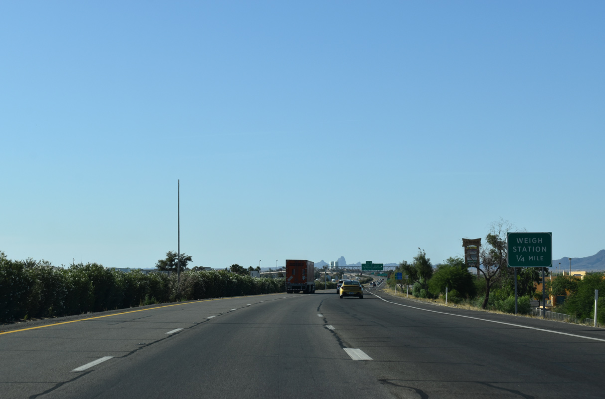
| Passing under U.S. 95 (16th Street), Interstate 8 proceeds west to the final Arizona weigh station and Exit 1 for Giss Parkway. 05/31/21 |
|
| Big box stores and other retail line the east side of Interstate 8 between the exchange with U.S. 95 and the forthcoming weigh station. 05/31/21 |
|
| Oleander bushes line the median leading west from the weigh station to Exit 1. This is a plant commonly used in the medians of many freeways and expressways in California. 05/31/21 |
|
| Giss Parkway connects I-8 with Business Loop I-8 (4th Avenue). Attractions for Exit 1 include historic Downtown Yuma, Yuma Crossing and Yuma Territorial Prison State Historic Park. Additionally the Yuma Chamber of Commerce is located in Downtown Yuma, and it functions as the de facto Arizona Welcome Center where free official state maps and tourist brochures may be obtained. 05/31/21 |
|
| Exit 1 leaves I-8 west for Giss Parkway and the Yuma city center. The succeding exit is for Business Loop I-8 to Imperial County Route S-24 and Winterhaven, California. 07/07/18 |
|
| Business Loop I-8 from Yuma seamlessly connects with the business route to Fort Yuma Indian Reservation and the Quechan Casino in Winterhaven. 05/31/21 |
|
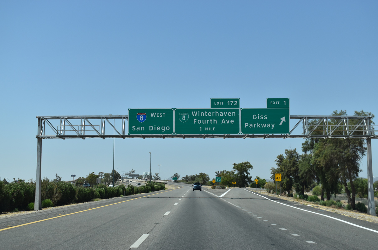
| I-8 continues west from Yuma eight miles to California State Route 186, 58 miles to El Centro and 177 miles to San Diego. SR 186 is significant because it travels south to the International border across from Baja California, Mexico. 07/07/18 |
|
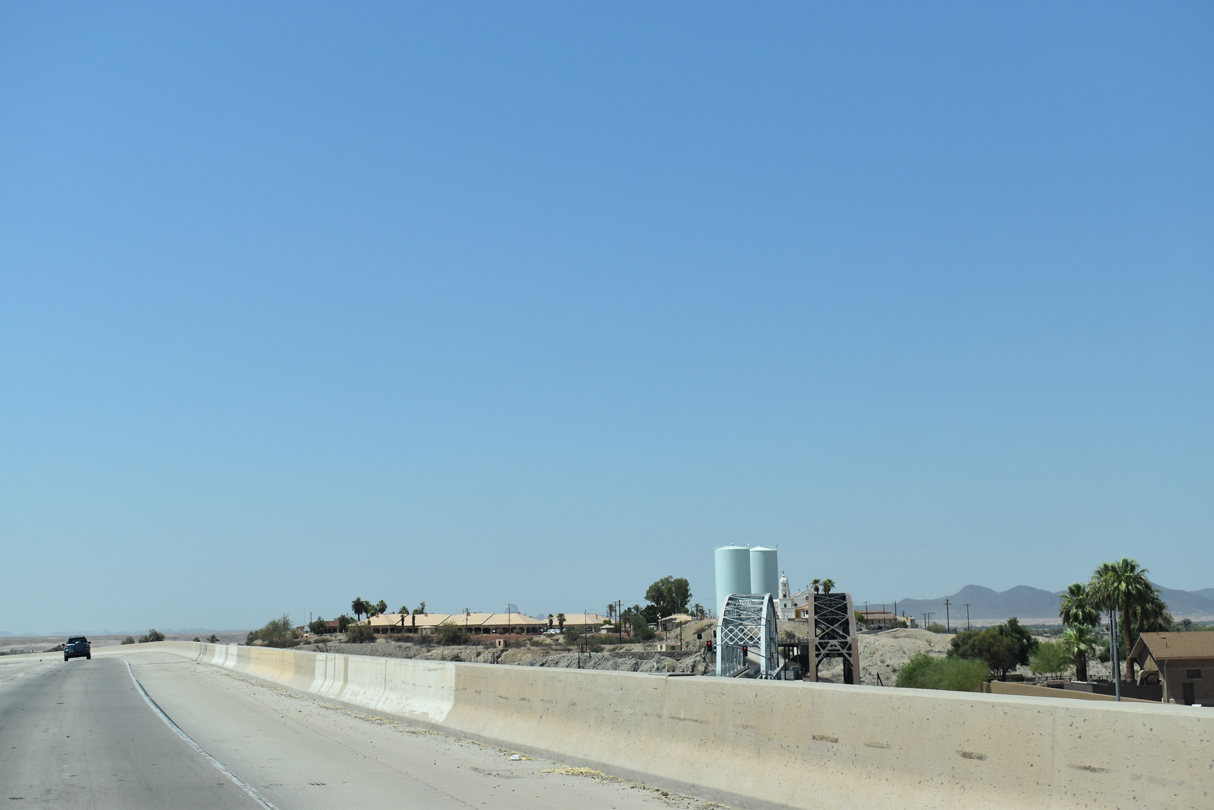
| Curving northwest, Interstate 8 crosses the Colorado River over a concrete deck bridge opened to traffic in 1979. 07/07/18 |
|
| Two steel through truss bridges are visible to the north of Interstate 8 across the Colorado River. The bridge along Business Loop I-8 between Yuma and Winterhaven can be seen to the south of the freeway. 07/07/18 |
|
| The southern bridge is the original, single lane U.S. 80 crossing over the Colorado River. The words "Ocean to Ocean Highway" and "Yuma" are written on the side of the span. 04/07/13 |
|
| Interstate 8 west enters Imperial County, California near the unincorporated community of Winterhaven. 07/07/18 |
Page Updated 04-26-2022.


 West
West