|
| Interstate 10 across lower Alabama is the Vietnam War Memorial Highway. Signs referencing the name were installed at both state lines in Winter 2012. 04/20/12 |
|
| The first shield for I-10 east in Mobile County stands next to an area of wetlands fed by Franklin Creek. 10/12/16 |
|
| The Alabama welcome center lies a half mile east of the state border. 10/12/16 |
|
| Interstate 10 continues east from the tourist information center between Hall Road and Reedy Branch. 10/12/16 |
|
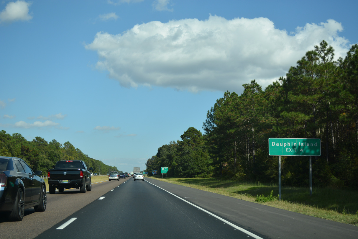
| The unincorporated community of Grand Bay lies just south of the first exit from I-10 in Alabama. 10/12/16 |
|
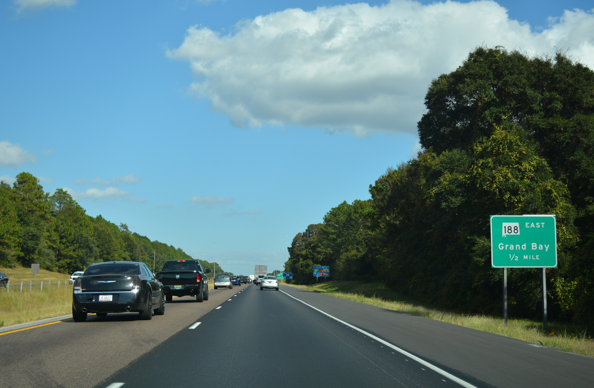
| SR 188 stems south from I-10 at Exit 4 to U.S. 90 in Grand Bay. The state route provides the most direct route to Dauphin Island on the Gulf of Mexico from the west. 10/12/16 |
|
| SR 188 runs 19.69 miles east from I-10 to SR 193 at Alabama Port. Alabama Port lies six miles north of Dauphin Island. 10/12/16 |
|
| A diamond interchange joins Interstate 10 with SR 188/CR 11 (Grand Bay Wilmer Road). SR 188 angles southeast from Grand Bay to the city of Bayou La Batre and Coden off Portersville Bay. 10/12/16 |
|
| County Route 11 extends Grand Bay Wilmer Road north from SR 188 and I-10 to Dees and Airport Boulevard (CR 56) west of Seven Hills. Jeff Hamilton Road (CR 36) and leads northeast to Dawes. 10/12/16 |
|
| Advancing east from Grand Bay, the ensuing stretch was the second longest along I-10 in Alabama between exits. That changed in 2005 when the exchange with CR 39 opened. 04/20/12 |
|
| The distance sign referencing Theodore predates the completion of Exit 10 north of Irvington. 04/20/12 |
|
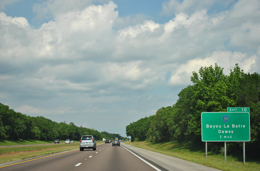
| The six-ramp parclo interchange linking I-10 with CR 39 (McDonald Road) opened to traffic on January 12, 2005. The exchange was the first of a three stage project improving access to the Irvington and Bayou La Batre areas.1 04/20/12 |
|
| Costing $16 million, McDonald Road (CR 39) was realigned east to meet I-10 at Exit 10. Completed in Summer 2005, the four lane highway was extended south from County Farm Road to U.S. 90 at Irvington in a separate $8 million project.1 04/20/12 |
|
| A distributor roadway departs at Exit 10 for CR 39 (McDonald Road) north to Dawes and south to Irvington. CR 39 south from U.S. 90 to Half Mile Road (CR 24) and Padgett Switch Road (CR 23) north of Bayou La Batre was completed by June 2009. 04/20/12 |
|
| The interchange with County Route 39 is named after retired U.S. Representative Sonny Callahan (R), who was instrumental in getting the project built. 10/01/09 |
|
| East of County Road 39, Interstate 10 crosses the Fowl River around 85 feet above sea level. 04/20/12 |
|
| Interstate 10 enters the Mobile city limits in four miles near Theodore and the Mobile central business district in 12 miles. 04/20/12 |
|
| Continuing northeast, I-10 meets Theodore Dawes Road (CR 30) at a diamond interchange (Exit 13) in one mile. 04/20/12 |
|
| Theodore Dawes Road (CR 30) leads east from I-10 to U.S. 90 and Hamilton Boulevard (CR 26) at Theodore. The five lane boulevard connects with Schillinger Road (CR 31) north to West Mobile. 04/20/12 |
|
| Exit 30 leaves I-10 east for Theodore Dawes Road (CR 30). Road construction in the early 2000s expanded CR 30 at I-10 to better accommodate truck traffic. 10/01/09 |
|
| Interstate 10 was widened from four to six lanes from the Carol Plantation Road northward to Exit 17 between March 2011 and Fall 2014. 11/21/14 |
|
| U.S. 90 leads 1.7 miles north from the community of Theodore to the succeeding exit with Interstate 10. Downtown Mobile is 11 miles to the northeast. 11/21/14 |
|
| Older guide signs for Exit 15 reference U.S. 90 as Historic Mobile Parkway. U.S. 90 generally constitutes a commercial arterial from Theodore northeast to Midtown in Mobile. Historically, the Tillman's Corner area was also known as Three Notches. 11/21/14 |
|
| The six-ramp parclo interchange (Exit 15) joining I-10 with U.S. 90 lies south of a heavily developed retail corridor in Tillman's Corner. 11/21/14 |
|
| Exit 15A departs I-10 east for U.S. 90 west into Theodore. This is the first meeting of I-10 and U.S. 90 since New Orleans, Louisiana. 11/21/14 |
|
| A loop ramp (Exit 15B) follows onto U.S. 90 east through Tillman's Corner. Carrying local and commuter traffic, U.S. 90 stays north of I-10 through Midtown Mobile. The two routes converge again east of Downtown at Exit 27. 11/21/14 |
|
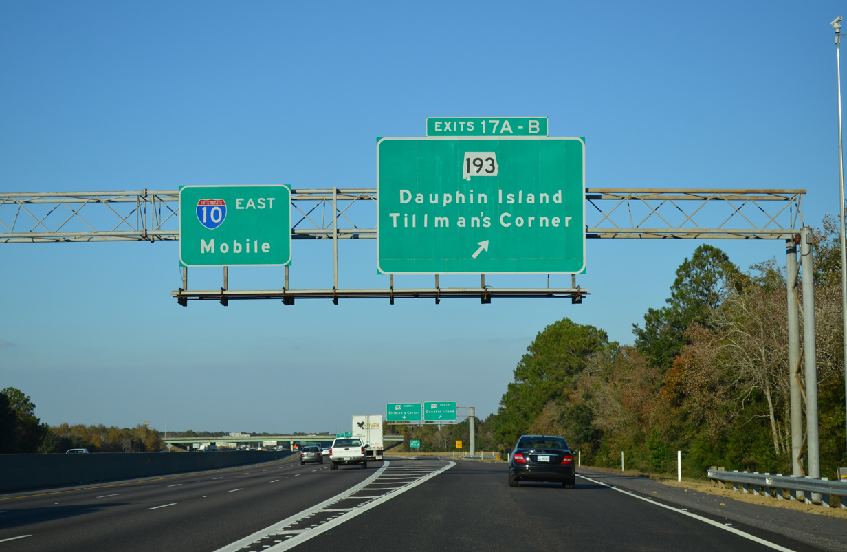
| A cloverleaf interchange (Exits 17A/B) joins Interstate 10 with SR 193 (Rangeline Road) along the east side of Tillman's Corner in one half mile. 11/21/14 |
|
| SR 193 was built in 1979 as a four lane highway linking the Tillman's Corner area with Hollingers Island. The state route replaced SR 163 southward across the Theodore Navigational Ship Channel to Dauphin Island. 11/21/14 |
|
| A collector distributor roadway separates for Exit 17 / SR 193 (Rangeline Road) beyond this shield assembly. 11/21/14 |
|
| Alabama State Route 193 measures 26.01 miles from the south abutment of Gordon Persons Bridge on Dauphin Island to a point along Nevius Road, 0.23 miles west of U.S. 90 in Tillman's Corner. 11/21/14 |
|
| A four lane highway from U.S. 90 to the Theodore Navigational Ship Channel bridge, SR 193 leads south from Mobile to the coastal communities of Bellefontaine, Bayleys Corner, Mon Louis and Alabama Port along the west shore of Mobile Bay. 11/21/14 |
|
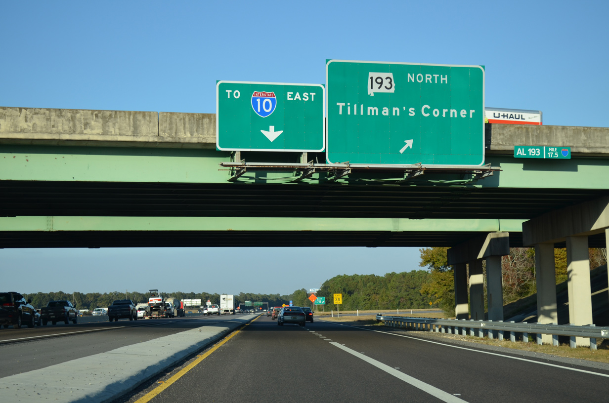
| Nevius Road extends west from SR 193 and Rangeline Road to Hillcrest Road. Linking U.S. 90 with Hillcrest Road to West Mobile, the Nevius Road Connector opened on November 24, 2010.2
The I-10 overhead here was a replacement installed in 2010. 11/21/14 |
|
| The c/d roadway for SR 193 merges back onto I-10 eastbound ahead of Halls Mill Creek. 11/21/14 |
|
| I-10 arcs northeast two miles from Halls Mill Creek to a directional T interchange (Exit 20) with Interstate 65. 11/21/14 |
|
| Interstate 10 crosses Halls Mill Creek, the previous city limits line for Mobile, near this shield marker. 11/21/14 |
|
| Riviere Du Chien Road spans I-10 near the Lloyds community in Mobile one mile ahead of Left Exit 20 for Interstate 65 north. Known as the Belt Line Highway in Mobile, I-65 travels nine miles north to I-165 in the city of Prichard. 04/20/12 |
|
| Interstate 65 joins the Gulf Coast with Montgomery, where I-85 branches northeast to Atlanta, Georgia, as I-65 continues north to Birmingham and Nashville, Tennessee. Locally I-65 is a well traveled commuter route north to Saraland. 10/08/21 |
|
| Left Exit 20 departs I-10 east for Interstate 65 north 171 miles to Montgomery. Overall I-65 runs 887 miles from Mobile to Gary, Indiana. Flashers and a 45 MPH placard were added to the overhead here in January 2003. 04/20/12 |
|
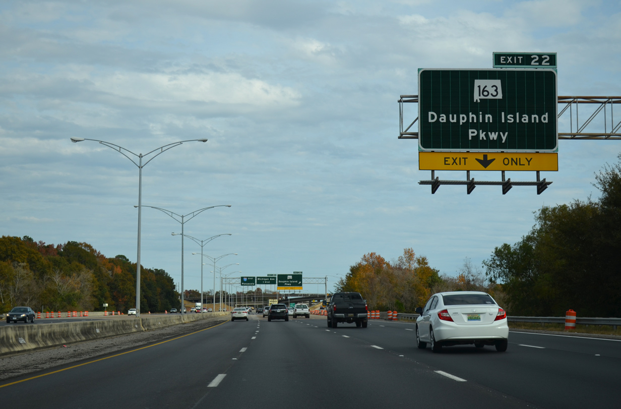
| The south end of I-65 ties into I-10 east from a left entrance ramp one mile ahead of Exit 22 for Dauphin Island Parkway (SR 163). 11/25/14 |
|
| A weaving traffic pattern ensues between I-65 and Exit 22 with a lane drop for SR 163 (Dauphin Island Parkway). SR 163 is an 11.10 mile long route from Hollingers Island to Midtown Mobile.
The large SR 163 shield replaced one removed by the winds of Hurricane Ivan in September 2004. 11/25/14 |
|
| Dauphin Island Parkway, known locally as DIP, constitutes a four lane boulevard linking Government Boulevard (U.S. 90) with Neshota, Forest Park and Dog River in south Mobile. 11/25/14 |
|
| Dauphin Island Parkway originally connected Mobile with Dauphin Island. This changed in the 1980s when the bridge over the Theodore Navigational Ship Channel to the south was removed and SR 163 was relocated westward to SR 193 via Hamilton Boulevard. 05/25/12 |
|
| Ramps from I-10 east and westbound combine over an adjacent CSX Railroad ahead of SR 163 (Dauphin Island Parkway). 06/15/09 |
|
| The three level cloverstack interchange joining I-10 and SR 163 (Dauphin Island Parkway) lies adjacent to the CSX Railroad line paralleling the freeway from Navco east toward Water Street in Downtown Mobile. 07/17/07, 11/25/14 |
|
| The entrance ramp from SR 163 expands eastbound I-10 with one general travel lane and an auxiliary lane to Exit 23 with Michigan Avenue. Michigan Avenue originates at Mobile Aeroplex at Brookley and Mobile Downtown Airport (BFM) nearby. 11/25/14 |
|
| Michigan Avenue leads north from the parclo interchange (Exit 23) with I-10 through residential areas to U.S. 90 (Government Street). Ladd Peebles Stadium, home of the Senior Bowl and University of South Alabama (USA) football, lies just west of Michigan Avenue via Virginia Street. 11/25/14 |
|
| Interstate 10 maintains eight overall lanes to Canal Street by Downtown Mobile. 11/25/14 |
|
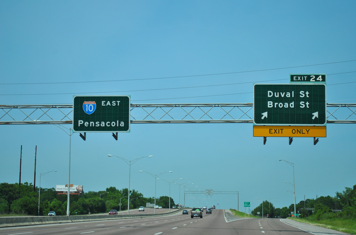
| A split diamond interchange (Exit 24) joins Interstate 10 with Duval and Broad Streets near the Birdville neighborhood in Mobile. 11/25/14 |
|
| Exit 24 departs I-10 east with two lanes to Duval and Broad Streets. Duval Street winds west to SR 163 (Dauphin Island Parkway) at Gosson Street and Halls Mill Road. Broad Street leads north from the Mobile Aeroplex at Brookley to U.S. 90/98 (Government Street) west of Downtown. 05/25/12 |
|
| The overhead at Duval Street referencing the Hazardous Cargo detour for the George C. Wallace Tunnel via Exit 26B (Water Street) was replaced by 2016 with a set of congestion ahead when flashing warning signs. 11/25/14 |
|
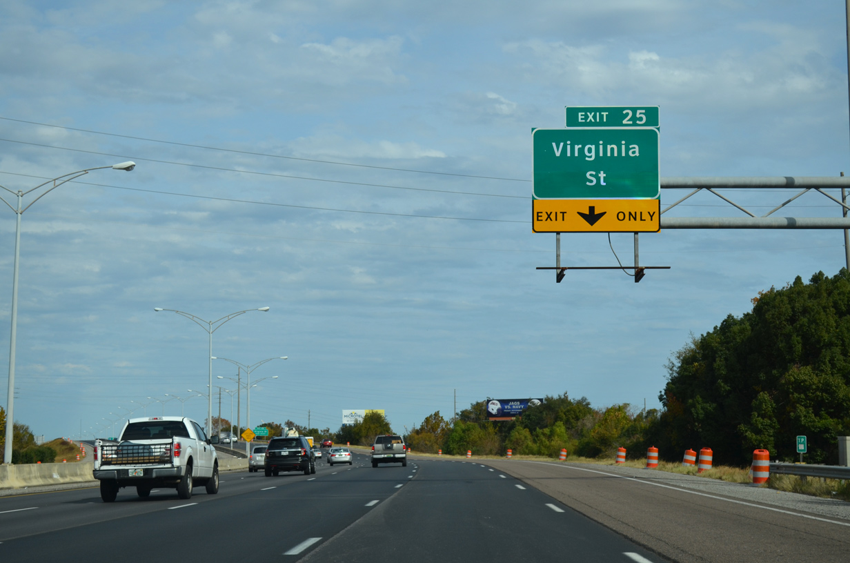
| Virginia Street leads east from Houston Street and Ladd Peebles Stadium to a parclo interchange (Exit 25) with Interstate 10. 11/25/14 |
|
| I-10 reduces to four overall lanes through the Wallace Tunnel. Posted by 2008, this sign is one of several referencing the increasing traffic congestion at the Mobile River due to growing commuter traffic to the Eastern Shore in Baldwin County. 11/25/14 |
|
| An auxiliary lane accompanies I-10 east from Broad Street to Virginia Street. This distance sign outlines the final three Mobile off-ramps. 11/25/14 |
|
| Virginia Street serves adjacent shipbuilding facilities along the Mobile River and the Mobile Container and McDuffie Terminals via the flyover south to McDuffie Island built in 2009. During Mardi Gras season, Exit 25 provides a viable alternate into the Downtown area via connections with Conception, Texas, and Royal Streets. 11/25/14 |
|
| Exit 25 departs Interstate 10 eastbound after the Tennessee Street under crossing to adjacent Lawrence Street south of Virginia Street. 11/25/14 |
|
| Interstate 10 parallels the Mobile River north from Virginia Street to Exit 26A for Canal Street and Downtown Mobile. 01/01/12 |
|
| A half diamond interchange (Exit 25A on I-10 west) joins Texas Street with I-10 east ahead of this confirming marker. 11/25/14 |
|
| The left lane on I-10 east ends at Virginia Street, followed by a second lane drop at Texas Street. An auxiliary lane opens from the Texas Street entrance ramp to Exit 26A for Canal Street. 11/25/14 |
|
| Preliminary plans for the new Mobile River Bridge included combining the succeeding exits for Canal Street and Water Street into a diverging diamond interchange (DDI) at Canal Street. 11/25/14 |
|
| Eastbound Interstate 10 reduces to two through lanes following lane drops for Canal Street and Water Street into Downtown Mobile. 06/05/17 |
|
| Canal Street heads west from the half diamond interchange (Exit 26A) with I-10 to Broad Street. Water Street extends the four lane boulevard northeast by area shipbuilding facilities. 06/05/17 |
|
| Jackson Street extends north from the off-ramp at Exit 26A to the Mobile Civic Center and Conception Street to the Mobile Government Center in Downtown. Parallel Claiborne Street represents the beginning of the main Mardi Gras parade route. 11/03/03 |
|
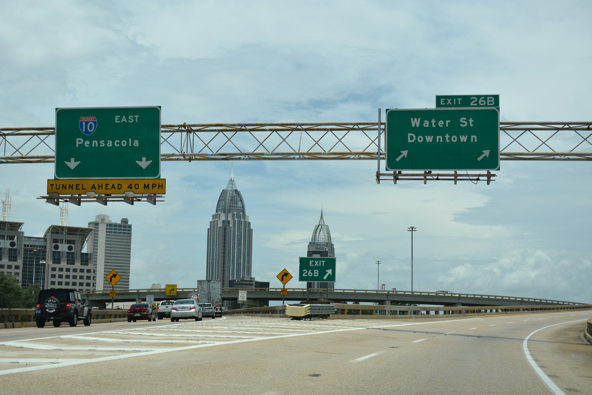
| Interstate 10 eastbound shifts onto a viaduct from Exit 26B to the George C. Wallace Tunnel approach. Exit 26B constitutes a flyover encircling Fort Condé to Water Street north along the Mobile Riverfront. 11/25/14 |
|
| The three-wye interchange with Water Street was originally constructed for the south end of I-210, a planned urban loop linking I-10 with I-65 at Prichard. The elevated route along Water Street was dropped from the route and I-165, a 4.3 mile spur north from U.S. 90 and Water Street, was built instead in 1994. 06/05/17 |
|
| Comprising a six lane boulevard, Water Street parallels the Mobile River north to the Arthur Outlaw Mobile Convention Center, the Alabama State Docks and the GM&O Transit Center at U.S. 90 (Beauregard Street) and I-165. 06/05/17 |
|
| The three lane flyover from I-10 converges with Water Street north at Government Street above the Bankhead Tunnel (U.S. 98). The Bankhead Tunnel ties into Government Street west at Conception Street. 06/05/17 |
|
| Mobile Government Center, RSA Tower, Alabama's tallest building, and Riverview Plaza rise just north of I-10 as the freeway lowers into the George C. Wallace Tunnel. 11/25/14 |
|
| Speed advisory signs precede the sharp curve taking Interstate 10 east into the George C. Wallace Tunnel. 11/25/14 |
|
| Previously a safety hazard due to the lack of a merge area, the adjacent entrance ramp from Water Street south to I-10 east permanently closed to traffic on June 1, 2017.3 11/25/14 |
|
| Traffic congestion is routine through the Wallace Tunnel during the evening peak hours and on holiday weekends. Shelved in August 2019, the planned Mobile River Bridge would have bypassed the tunnel to the south with expanded capacity. 11/25/14 |
|
| Exit 27 joins Interstate 10 east with U.S. 90/98 (Battleship Parkway) just beyond the Wallace Tunnel in 0.75 miles. 11/25/14 |
|
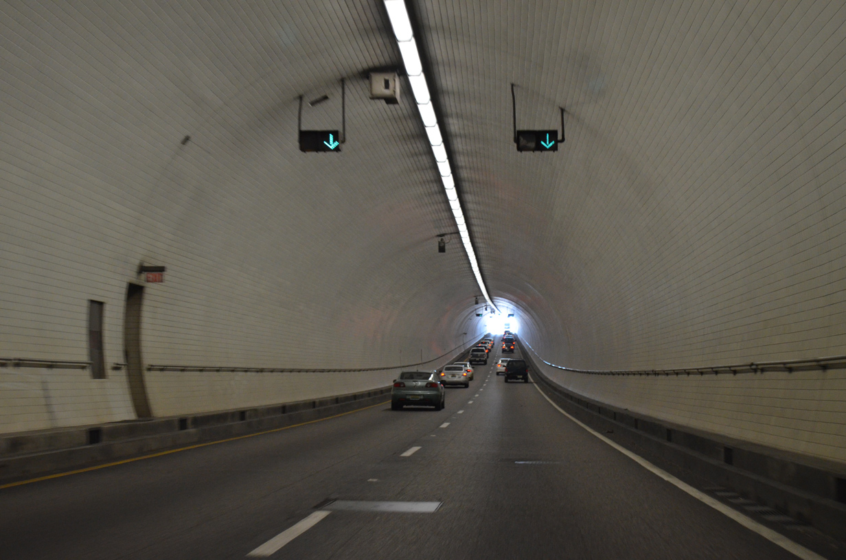
| Interstate 10 enters the George C. Wallace Tunnel below historic Fort Condé. Dating from the Spanish-American War, most of Fort Condé constitutes a reproduction of the original structure. 11/25/14 |
|
| A dual tunnel four overall lanes, the Wallace Tunnel is 3,000 feet long.4 11/25/14 |
|
| Costing approximately $50 million, the George C. Wallace Tunnel opened to traffic on February 9, 1973.5 11/25/14 |
|
| A tunnel was built instead of a bridge for I-10 to reduce impacts to shipping interests along the Mobile River. The Mobile River represents the southern leg of the Tennessee-Tombigbee River system from Appalachia to the Gulf of Mexico. 11/25/14 |
11/03/03, 07/17/07, 06/15/09, 10/01/09, 01/01/12, 04/20/12, 05/25/12, 11/21/14, 11/25/14, 10/12/16, 06/05/17, 10/08/21 by AARoads
Page Updated 11-19-2020.

 East
East