|
| I-10 meets U.S. 90 (Scenic Highway) at Exit 17 and the west end of the Escambia Bay bridges. The two routes previously converged at Midway, 175 miles to the east. Scenic Highway is named after the bluffs along the west shore of Escambia and Pensacola Bays in Pensacola. 03/17/12 |
|
| Nicknamed the "Crooked Bridge" by some locals, the Escambia Bay Bridge kinks northward, tying into the original bridge footprint at the U.S. 90 overpass. The curve allowed crews to maintain travel on at least one of the 1969 spans while construction progressed on their replacements. 11/19/08 |
|
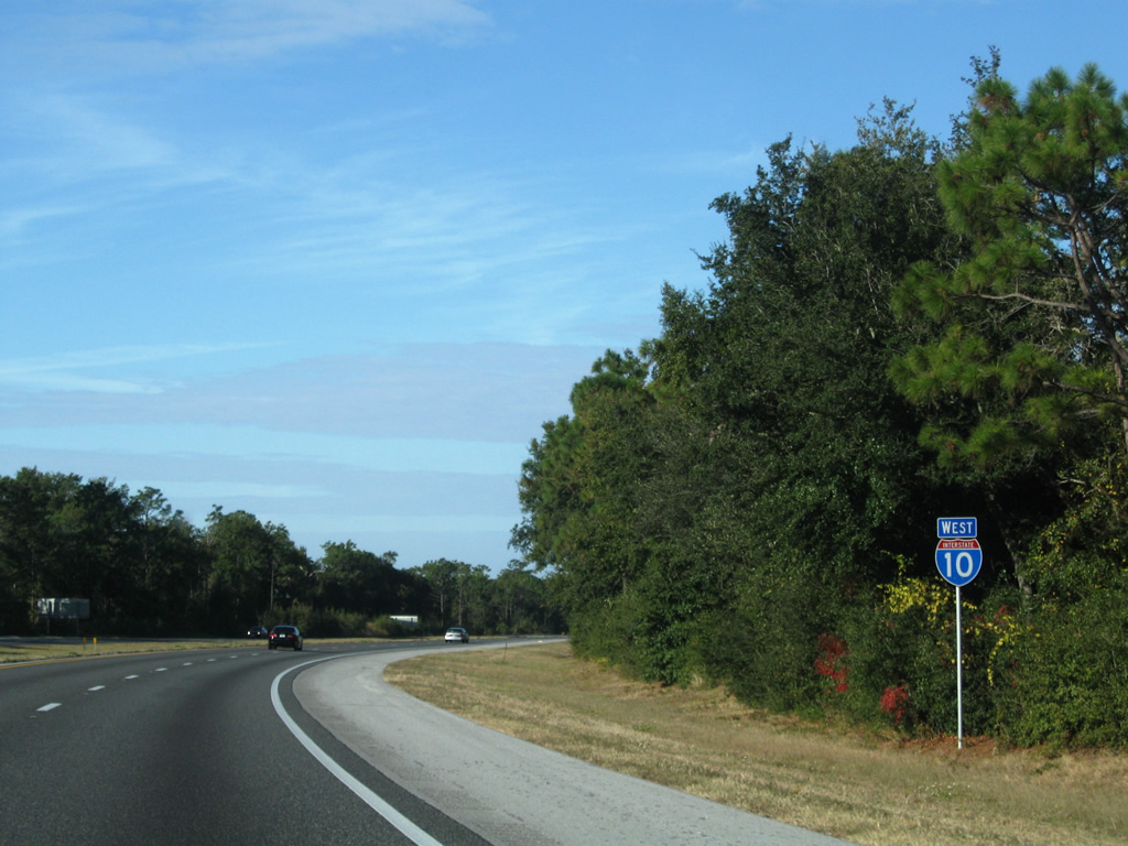
| A lane drop previously occurred along I-10 west at Exit 17 for U.S. 90 (Scenic Highway). Road work widened I-10 between U.S. 90 and SR 291 at Exit 13 from 2013 to January 2018. 08/03/11 |
|
| U.S. 90 straddles the Escambia Bay coastline southward to Bayou Texar and northward to the Escambia River crossing into Pace. 08/03/11 |
|
| U.S. 90 doubles as the Pensacola Bluffs Scenic Highway from Bayou Texar to Nine Mile Road (U.S. 90 Alternate). Traffic signals were installed at the end of this ramp in March 2004. 11/21/08 |
|
| Turning westward from Escambia Bay, Interstate 10 advances through the community of Ferry Pass. 11/23/08 |
|
| I-10 enters northern reaches of the Pensacola city limits at the SR 289 (N 9th Avenue) overpass. An interchange was proposed with SR 289 between SR 742 (Creighton Road) and CR 290 (Olive Road) from 1970 onward. 05/06/16 |
|
| A new entrance ramp to I-10 west from SR 291 (Davis Highway) south was added to the folded diamond interchange at Exit 13 in 1998. This ramp was later incorporated into the collector distributor roadway for Interstate 110 south. 05/06/16 |
|
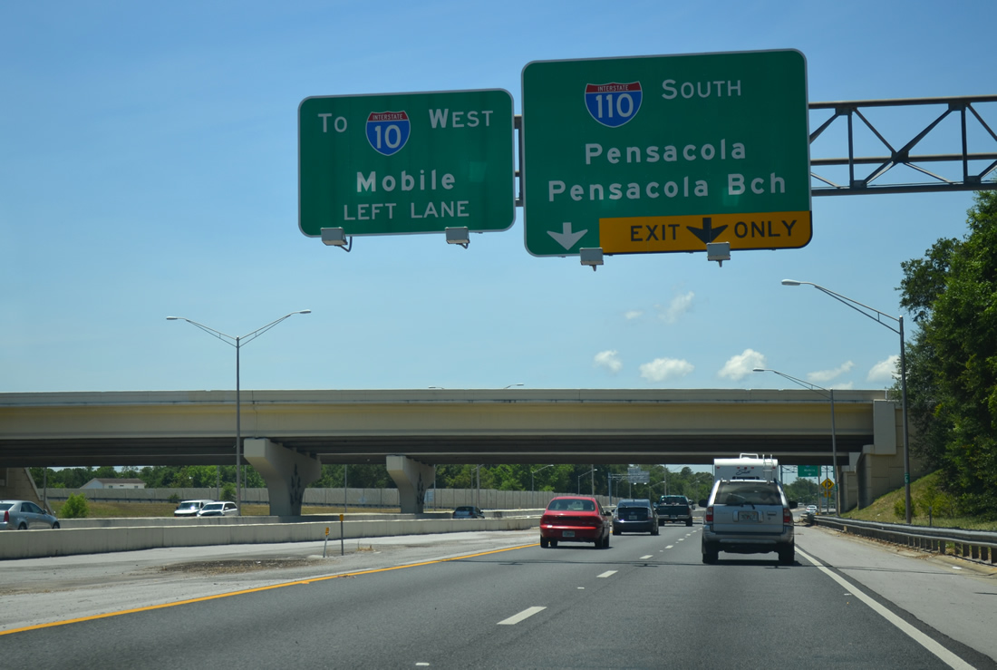
| A two lane flyover departs just beyond Exit 13 for SR 291 (Davis Highway) to Interstate 110 south into Pensacola. 11/21/14 |
|
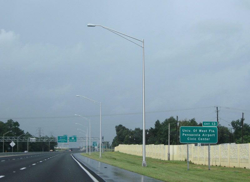
| Davis Highway is a heavily traveled arterial paralleling I-110 south to U.S. 98 Business near the Pensacola Bayfront Center. SR 291 links with the University of West Florida (UWF) via University Parkway to the north and Pensacola International Airport (PNS) via Airport Boulevard (SR 750) east. 09/01/08 |
|
| Widening I-10 from four to six lanes between Exit 13 and 10 and work at SR 291 and I-110 began in 2003. Associated work completed in 2002 reconstructed Davis Highway north to Olive Road (CR 290) and University Parkway and south along SR 291 to University Town Plaza (former University Mall) in 2006. 05/06/16 |
|
| SR 291 follows Davis Highway north to U.S. 90 Alternate (Nine Mile Road) near UWF and south to a one way couplet (Davis Street / MLK Street) within the Pensacola street grid. 05/06/16 |
|
| Interstate 110 heads south from Exit 12 to Brent, Downtown Pensacola and U.S. 98 for the Pensacola Bay Bridge toward Gulf Breeze and Pensacola Beach. 05/06/16 |
|
| Interstate 110 was expanded south to Exit 5 (SR 296) during the I-10-110 project. That work tied into widening and reconstruction of I-110 southward to Exit 3 (Maxwell / Jordan Streets) through 2009. 05/06/16 |
|
| Flyovers were built at the trumpet interchange with I-110 in 2008. 11/21/14 |
|
| Miniature Blue Angel replicas on the flyover supports at the I-10/110 exchange acknowledge the demonstration flight squadron based out of Pensacola Naval Air Station. 11/21/14 |
|
| A loop ramp joins the distributor roadway from SR 291 (Davis Highway) with I-110 south. I-110 travels 6.34 miles south to U.S. 98 Business (Garden Street) and U.S. 98 (Chase Street) by the Pensacola Bayfront Center. 05/27/13 |
|
| The original I-110 overpasses were refurbished in 1997/98 as part of an upgrade of I-10 related bridges and overpasses throughout Escambia County. These were again improved during the project completed in 2008. 11/24/14 |
|
| Construction finished in October 2018 removed the loop ramp at Exit 10A and expanded Exit 10B to two lanes with a signalized turn for U.S. 29 (Pensacola Boulevard). The $8.5 million project1 preceded future work reconfiguring the remainder of the exchange. 06/05/17 |
|
| Widening from four to six lanes along I-10 between Exit 12 and 10B was completed by 2007. Representing the busiest segment of I-10 in Florida west of Jacksonville, 65,000 vehicles per day were recorded by FDOT on this stretch in 2012. 11/21/14 |
|
| Exit 10 departs from I-10 west beyond the CSX Railroad and CR 95A (Palafox Street) overpasses for U.S. 29 (Pensacola Boulevard) south to Brent and north to Ensley. Pensacola Boulevard was widened to six and eight lanes south to Pensacola in 1998. 06/05/17 |
|
| Exit 10B was previously expanded to two lanes in 2002, improving access to U.S. 29 (Pensacola Boulevard) north to the Gonzalez and Cantonment communities. Further north, U.S. 29 is the main route to Interstate 65 in Lower Alabama. 05/06/16 |
|
| The former exit ramp for U.S. 29 south. New side by side roadways for I-10 will be constructed through the exchange at Exit 10 during road work anticipated for 2023. The existing roadways will be repurposed into the ramp system with U.S. 29. 10/11/16 |
|
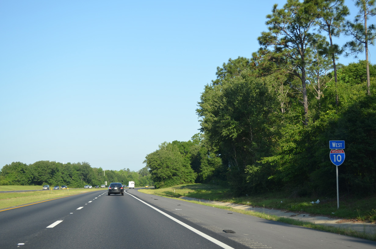
| Interstate 10 proceeds northwest from Ensley between Beulah and Muscogee. The speed limit increases from 60 to 70 MPH on this stretch, which will be expanded to six lanes during construction from 2023 onward. 05/09/15 |
|
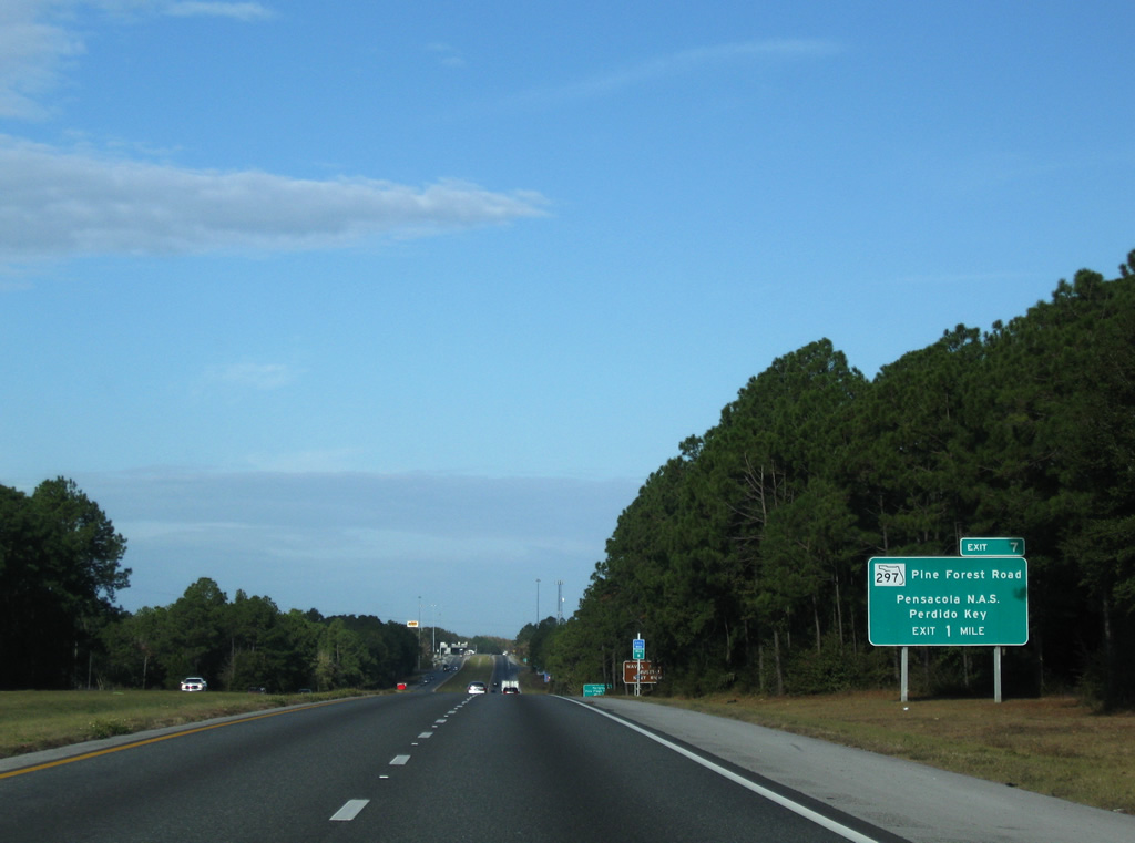
| Lowering toward Eight Mile Creek, I-10 advances west to Exit 7 for SR 297. Original concrete roadways along I-10 between Exit 10 and the Alabama state line were paved over with asphalt in 2002. 11/23/08 |
|
| Five Flags Speedway, home of the SnowBall Derby stock car race, and Pensacola Interstate Fairgrounds lie southward along Pine Forest Road (SR 297). Saufley Field is a short drive west via CR 296 from either U.S. 90 or SR 173. 11/21/14 |
|
| An arterial route, State Road 297 measures 4.29 miles between U.S. 90 (Mobile Highway) at Bellview and U.S. 90 Alternate (Nine Mile Road) at Pine Forest. 05/09/15 |
|
| SR 297 south connects with SR 173 (Blue Angel Parkway) in 2.5 miles for Pensacola Naval Air Station, including the National Museum of Naval Aviation Museum, and Perdido Key. 06/05/06 |
|
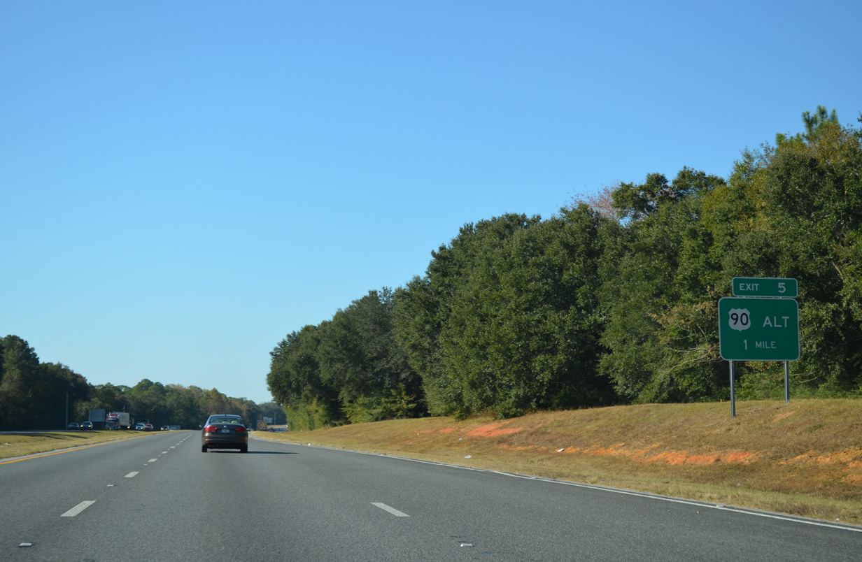
| A diamond interchange (Exit 5) joins Interstate 10 with U.S. 90 Alternate (Nine Mile Road) in one mile. 11/21/14 |
|
| Reassurance marker posted for I-10 west near Eight Mile Creek Road. 11/21/14 |
|
| U.S. 90 Alternate (Nine Mile Road) heads west from Pine Forest to meet I-10 at Exit 5, five miles from its merge with U.S. 90 at Beulah. U.S. 90 continues west from there to Seminole, Alabama. 11/21/14 |
|
| Due to growing commuter traffic, a traffic light was added at Exit 5 for U.S. 90 Alternate by 2012. Four laning the remainder of Nine Mile Road through Summer 2021 extends west to SR 99 (Beulah Road) and east back to U.S. 29. Westward into Alabama, U.S. 90 meets I-10 again in 37 miles at Spanish Fort. 08/01/06 |
|
| Interstate 10 spans Eleven Mile Creek just north of Nine Mile Road. An FDOT PD&E Study through Summer 2021 involves widening I-10 west to the Perido River to six lanes and constructing a new interchange with SR 99 at Beulah Road. 11/21/14 |
|
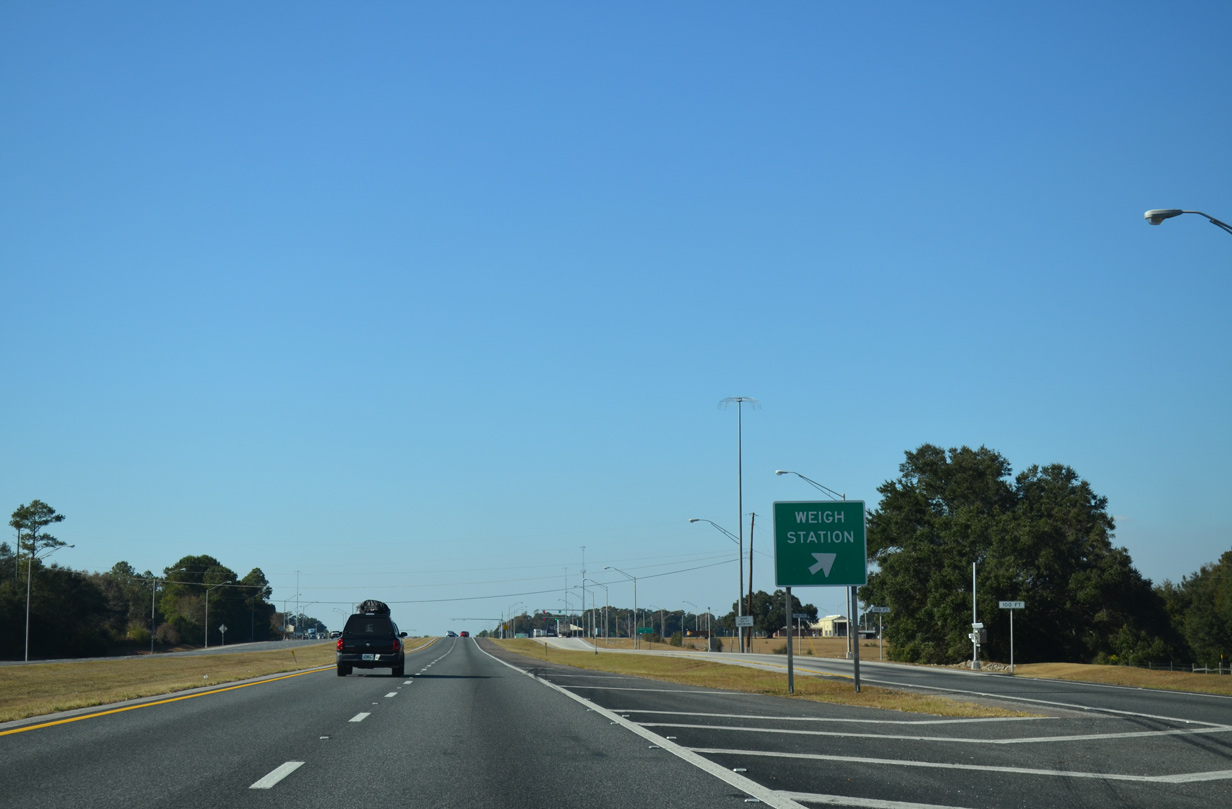
| Interstate 10 continues northwest from Exit 5 to a set of weigh stations. 11/21/14 |
|
| The weigh stations along Interstate 10 near Beulah opened in November 2003. 11/21/14 |
|
| The succeeding exit along I-10 west lies 15 miles ahead with CR 64 (Wilcox Road) in Alabama. The 18 mile exit less stretch is the longest along I-10 west of Lake City, Florida and east of Hudspeth County, Texas. 11/21/14 |
|
| A tourist information center and rest area lie just west of the Perdido River in Baldwin County, Alabama along Interstate 10. 06/05/17 |
|
| Florida welcome and thank you for visiting monuments were constructed along Interstate 10 by the Perdido River in 2016. 06/05/17 |
|
| Reconstructed in 1993, the Interstate 10 bridges crossing the Perdido River opened in 1966. 05/09/15 |
06/05/06, 08/01/06, 09/01/08, 11/19/08, 11/21/08, 11/23/08, 08/03/11, 03/17/12, 05/27/13, 11/21/14, 11/24/14, 05/09/15, 05/06/16, 10/11/16, 06/05/17 by AARoads
Page Updated 11-24-2020.

 West
West