|
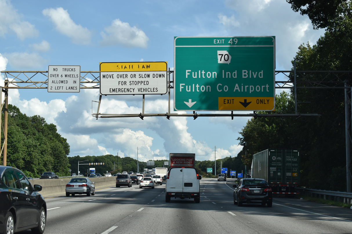
| I-20 continues east from the Chattahoochee River to Fulton County Industrial Park and the diamond interchange (Exit 49) with SR 70 (Fulton Industrial Boulevard). 09/11/20 |
|
| SR 70 (Fulton Industrial Boulevard) angles southwest to SR 154/166 (Campbellton Road). SR 70-154-166 combine west to Douglas County, where they join with SR 92 on the return to Fulton County. 09/11/20 |
|
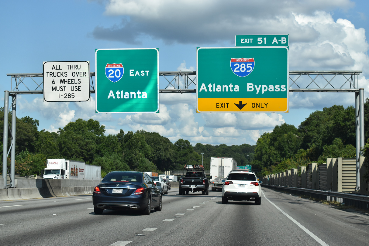
| Entering the city of Atlanta, I-20 advances to the directional cloverleaf interchange (Exits 51A/B) with Interstate 285. 09/11/20 |
|
| With a loop ramp (Exit 51B) onto I-285 north and left exit ramps in every direction except for I-20 east, the exchange on the west side of Atlanta is virtually unchanged from its original design. The I-285/I-20 West Interchange Reconstruction and Interstate Widening Project will reconstruct Exit 51 into a systems interchange. 09/11/20 |
|
| I-285 comprises a 62.65 mile long beltway encircling Atlanta between East Point to the southwest and Chamblee to the northeast. 09/11/20 |
|
| Exit 51A joins I-20 east with Interstate 285 (Perimeter Highway) south to Greenbrier in Atlanta, College Park and East Point. The beltway meets Interstate 85 southwest to Montgomery in 10.5 miles. 09/11/20 |
|
| I-285 connects I-20 with I-75 northwest to Marietta and Chattanooga, Tennessee and I-75 southeast to Macon and Tampa, Florida. 09/11/20 |
|
| Interstate 285 continues 9.5 miles north from Exit 51B to I-75 (Exit 20) near the city of Smyrna. The Tom Mooreland Interchange with I-85 at Doraville is 22 miles away via the Perimeter Highway. 07/15/05 |
|
| Ramps from Interstate 285 merge onto I-20 east the Linkwood Road overpass, one half mile west of Exit 52 for SR 280 (Hamilton E. Holmes Drive). 06/30/17 |
|
| Interstate 20 continues east from the Atlanta Perimeter Highway to a parclo interchange (Exit 52) with Hamilton E. Holmes Drive (SR 280). SR 280 begins nearby at SR 139 (Martin Luther King, Jr. Drive). 06/30/17 |
|
| Exit 52 leaves I-20 east for Burton Road to SR 280 (Hamilton E. Holmes Drive) just north of SR 139 and the MARTA Hamilton E. Holmes Station. SR 280 heads north to the Collier Heights and Center Hill neighborhoods. An 18.28 mile long route, SR 280 extends northward to I-75 at Exit 261 in Marietta. 06/30/17 |
|
| I-20 (Ralph D. Abernathy Freeway) and SR 139 (Martin Luther King, Jr. Drive) come together at Exit 53. Beginning from U.S. 78/278 at Mableton in Cobb County, SR 139 meanders 15.84 miles east from SR 70 to U.S. 29/SR 14-154 (Whitehall Street) at the West End neighborhood of Atlanta. 06/30/17 |
|
| Interstate 20 crosses over MARTA tracks with eight overall lanes to the south of Dixie Hills. 06/30/17 |
|
| A split diamond interchange (Exit 53) joins Interstate 20 with parallel SR 139 (MLK, Jr. Drive), Anderson Avenue and W Lake Avenue in a half mile. 06/30/17 |
|
| Exit 53 departs I-20 east for adjacent SR 139 (Martin Luther King Jr., Drive). SR 139 splits with MLK Drive at Anderson Avenue for Ralph David Abernathy Boulevard (Gordon Street) southeast to Westview. MLK Drive continues east to U.S. 19-29-41 (Northside Drive) at Mercedes-Benz Stadium. 06/30/17 |
|
| Westview Drive and West End Trail pass over I-20 by the Mozley Park neighborhood ahead of a half diamond interchange (Exit 54 from I-20 west) with Langhorn Street. Exit 55A follows for Lowery Boulevard and the West End section of Atlanta. 06/30/17 |
|
| Downtown Atlanta is two miles to the east, and the exits leading toward the central business district culminate at Exit 57 for I-75/85. 06/30/17 |
|
| The Capitol Hill Interchange joins Interstate 20 with I-75/85 (Downtown Connector) two miles beyond the Langhorn Street entrance ramp. 06/30/17 |
|
| West End is home to Wren's Nest, a Queen Anne style house built in 1870 that was the home of journalist Joel Chandler Harris.1 Harris (1848-1908) was an editor of the Atlanta Constitution and the author of the Uncle Remus Tales.2 Atlanta University Center lies north of Exit 55A. 06/30/17 |
|
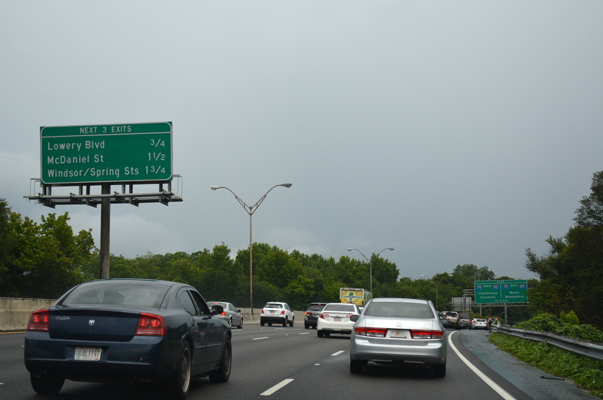
| Midway between Exit 55A to Lowery Boulevard and the systems exchange with I-75/85 are ramps for Exits 56A (McDaniel Street) and 56B (Windsor Street / Ted Turner Drive). Rev. Joseph E. Lowery Boulevard superseded Ashby Street between White Street and W Marietta Street (former SR 3). 06/30/17 |
|
| Exit 55A departs from I-20 onto adjacent Oak Street east to Rev, Joseph E. Lowery Boulevard and U.S. 29/SR 14-154 (Whitehall Street). A pair of half diamond interchanges provide return access to I-20 east from Lowery Boulevard and parallel Lee Street. 06/30/17 |
|
| I-20 east continues over U.S. 29/SR 14-154 (Whitehall Street), a Norfolk Southern Railroad line and Murphy Avenue. U.S. 19/41 (Metropolitan Parkway) combine with U.S. 29 along Northside Drive north to Mercedes-Benz Stadium (home of the Atlanta Falcons), State Farm Arena (home of the Atlanta Hawks) and the Georgia World Congress Center. 06/01/07 |
|
| I-75/85 (Downtown Connector) overlap for 7.40 miles from Hapeville to Midtown Atlanta. I-75 links Atlanta with the cities of Chattanooga, Tennessee and Macon and I-85 with Montgomery, Alabama and Greenville, South Carolina. 06/30/17 |
|
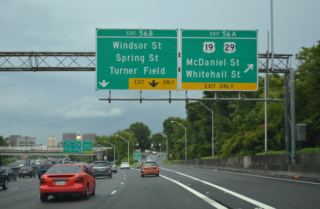
| An auxiliary lane joins I-20 east from Lee Street to the half diamond interchange (Exit 56A) with McDaniel Street. McDaniel Street heads north to adjacent Whitehall Street (former U.S. 29), parallel Peters Street (SR 14/154) and Northside Drive (U.S. 19-29-41/SR 3). 06/30/17 |
|
| Three ramps depart Interstate 20 (Ralph D. Abernathy Freeway) over the course of 0.75 miles. Windsor Street / Ted Turner Drive, served by Exit 56B, connect Downtown Atlanta with Mechanicsville to the west of Center Parc Credit Union Stadium. 06/30/17 |
|
| Exit 56A departs from I-20 east to McDaniel Street for U.S. 19-29-41/SR 3-14-154. Exit 56B follows just beyond the McDaniel Street overpass for Windsor Street south, Ted Turner Drive (formerly Spring Street) north and Rawson Street east. 06/30/17 |
|
| Two lanes separate from the eight lane freeway for I-75/85 at Exit 57. Rawson Street stems east from Exit 56B to Pryor Street, Central Avenue and Pulliam Street south. 06/30/17 |
|
| The Georgia State Capitol dome comes into view beyond the forthcoming MARTA viaduct, one quarter mile from the Downtown Connector (Exit 57) and two miles west of Grant Park. 06/01/07 |
|
| Exit 57 parts ways with I-20 above Windsor Street. The Capitol Hill interchange at I-75/85 was reconstructed between 1986 and June 1989 as part of the 17 year, $1.4 billion, "Freeing the Freeways " campaign by GDOT.3 Redesign eliminated several left exit ramps and reconfigured the I-20 mainline to run through the middle of the exchange. 06/01/07 |
|
| Two lanes join I-75/85 (Downtown Connector) northbound ahead of the exit for Edgewood Avenue by Georgia State University. I-75/85 wind northward from the State Capitol by Georgia Tech to Midtown before splitting to Marietta and Buford. Southward I-75/85 partition north of ATL Airport. 06/01/07 |
|
| Three lanes continue along Interstate 20 east toward Exit 59A for Boulevard. Prior to the late 80s Freeing the Freeways reconstruction of I-20, a full diamond interchange (old Exit 25) connected eastbound with Hill Street. 07/15/05 |
|
| A half diamond interchange links Capitol Avenue with I-20 east beyond the ramps from the Downtown Connector. 04/13/12 |
|
| Interstate 20 eastbound swells to six overall lanes with an auxiliary lane between Capitol Avenue and Exit 59A to Boulevard. Boulevard leads south to Grant Park, which is home to Zoo Atlanta. 04/13/12 |
|
| Boulevard leads north from the diamond interchange at Exit 59A to the Martin Luther King, Jr. National Historic Site and U.S. 29-78-278 (Ponce De Leon Avenue) at Monroe Drive. Southward Boulevard continues from Grant Park to McDonough Boulevard (SR 42 Spur). 04/13/12 |
|
| Exit 59B consists of a slip ramp onto a collector distributor roadway leading east from Boulevard to a half diamond interchange with Bill Kennedy Way. 04/13/12 |
|
| Bill Kennedy Way was constructed over an Atlanta and West Point Railroad line to connect I-20 with Memorial Drive (SR 154) to the north and Glenwood Avenue to the south. 04/13/12 |
|
| The left lane of I-20 east is restricted to HOV-2 traffic beyond the Boulevard overpass. The HOV lane was added as part of an $80 million expansion project for I-20 from Boulevard to Columbia Drive (Exit 66).4 Widening between January 1991 and June 1994 increased the number of lanes from six to ten. 04/13/12 |
|
| Forthcoming Exit 60 is a six-ramp parclo interchange with U.S. 23/SR 42 (Moreland Avenue) at the Reynoldstown neighborhood of Atlanta. 04/13/12 |
|
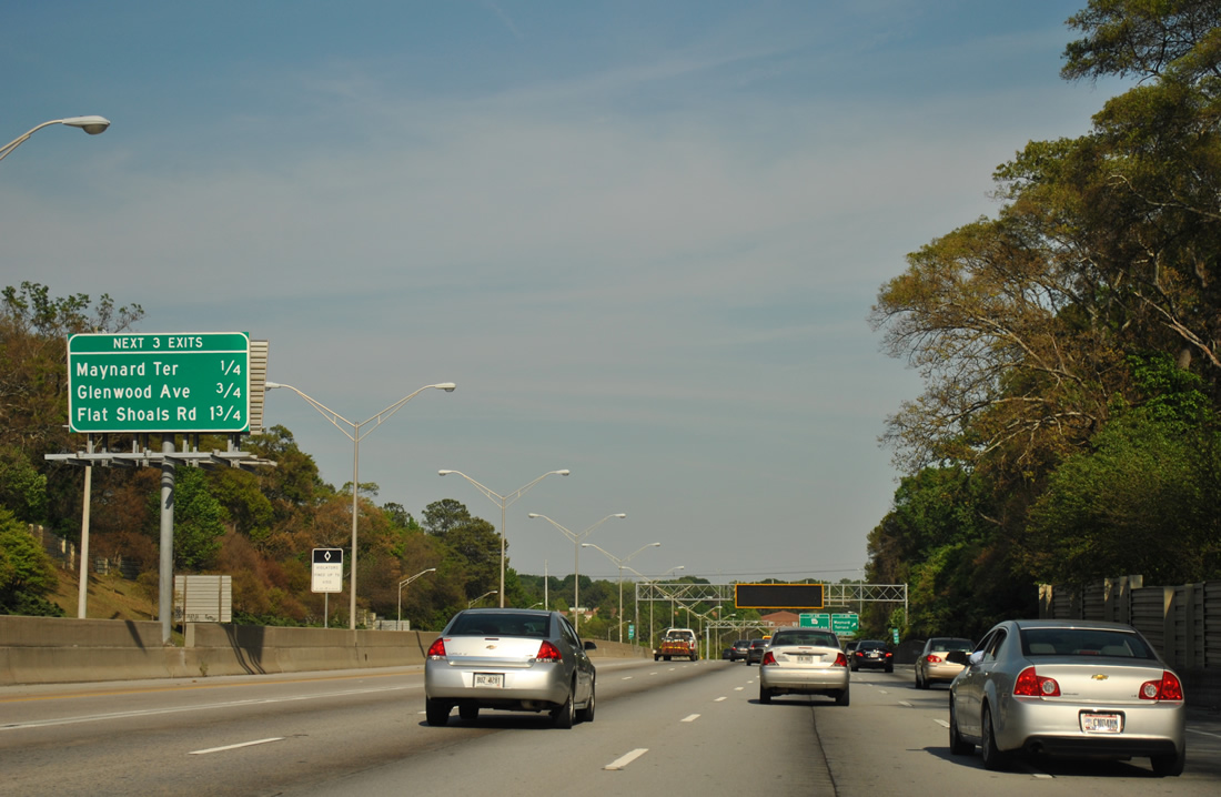
| Removed by 2012, an interchange sequence sign preceded Exits 60A/B by one quarter mile. Maynard Terrace and Glenwood Avenue follow at Kirkwood and East Atlanta within 1.5 miles. 07/15/05 |
|
| Exit 60A departs I-20 (Ralph D. Abernathy Freeway) east for U.S. 23/SR 42 (Moreland Avenue) south to Ormewood Park, Woodland Hills and Thomasville along the Atlanta city line. U.S. 23 advances from the city to I-285 at Exit 53 and Conley in Clayton County. 04/13/12 |
|
| U.S. 23/SR 42 follow Moreland Avenue north from Reynoldstown and I-20 to Little Five Points and U.S. 29-78-278 (Ponce De Leon Avenue). There the two part ways with SR 42 following Briarcliff Road (old U.S. 23) to Druid Hills Road and I-85, and U.S. 23 joining U.S. 29/78 east to Clairmont Road in Decatur. 04/13/12 |
|
| Maynard Terrace meets Interstate 20 at a half diamond interchange (Exit 61A) in one quarter mile. Glenwood Avenue provides return access at an adjacent diamond interchange (Exit 61B). 04/13/12 |
|
| Interstate 20 curves southward at Exit 61A to Maynard Terrace. The local street heads south to the East Atlanta neighborhood and north to SR 154 (Memorial Drive) at Wyman Street and the Kirkwood neighborhood. 04/13/12 |
|
| Clifton Street passes over I-20, 1.25 miles from Flat Shoals Road, the final Atlanta exit. Gresham Road is the first of four Dekalb County interchanges preceding Interstate 285. 04/13/12 |
|
| Glenwood Avenue doubles as SR 260 west from I-20 to U.S. 23/SR 42 (Moreland Avenue) at Ormewood Park. SR 260 used to continue east from Exit 61B to Glenwood Hills and U.S. 278/SR 12 (Covington Highway) beyond the Perimeter Highway. 04/13/12 |
|
| Facing south alongside Sugar Creek, Interstate 20 travels one mile to the half diamond interchange (Exit 62) with Flat Shoals Road. 04/13/12 |
|
| Flat Shoals Road branches southeast from U.S. 23/SR 42 (Moreland Avenue) near Exit 60 through East Atlanta to leave the city at Exit 62 and Fayetteville Road. 04/13/12 |
|
| I-20 advances 1.5 miles east to Gresham Road and 3.75 miles to Candler Street (SR 155). 04/13/12 |
|
| Exit 62 parts ways with I-20 east for Flat Shoals Road. Flat Shoals Road parallels the freeway to the succeeding exit before turning east at Clifton Church Road and SR 155 (Candler Street). 04/13/12 |
Page Updated 06-16-2021.

 East
East