|
| U.S. 70 combines with Interstate 40 west for 3.83 miles. 02/15/19 |
|
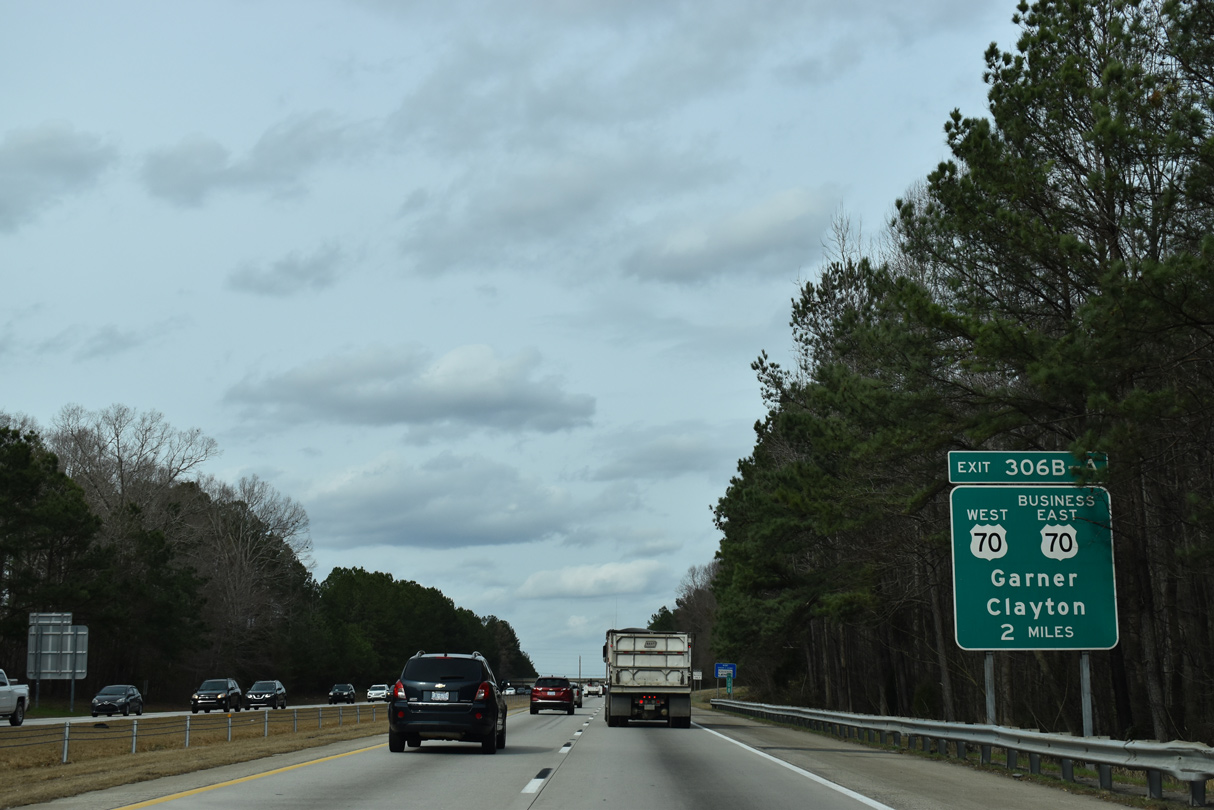
| I-40/U.S. 70 west split at Exit 306 with U.S. 70 Business east in Garner. 02/15/19 |
|
| Exit 306B connects with U.S. 70 Business east to the town Clayton. A nearby parclo interchange joins the four lane highway with Greenfield Parkway (SR 4142). 02/15/19 |
|
| 2018-22 widening of I-40 northward from NC 42 to I-440 in Raleigh removed the loop ramp from U.S. 70 east to I-40 west and realigned the ramps for Exits 306B/A to improve geometry. 02/15/19 |
|
| U.S. 70 branches northwest from Exit 306A into the town of Garner. U.S. 70 meets I-40 again along side U.S. 401 (S Saunders Street) at Exit 298 in south Raleigh. 02/15/19 |
|
| Jones Sausage Road (SR 5220) parallels Interstate 40 north from U.S. 70 to Exit 303. 02/15/19 |
|
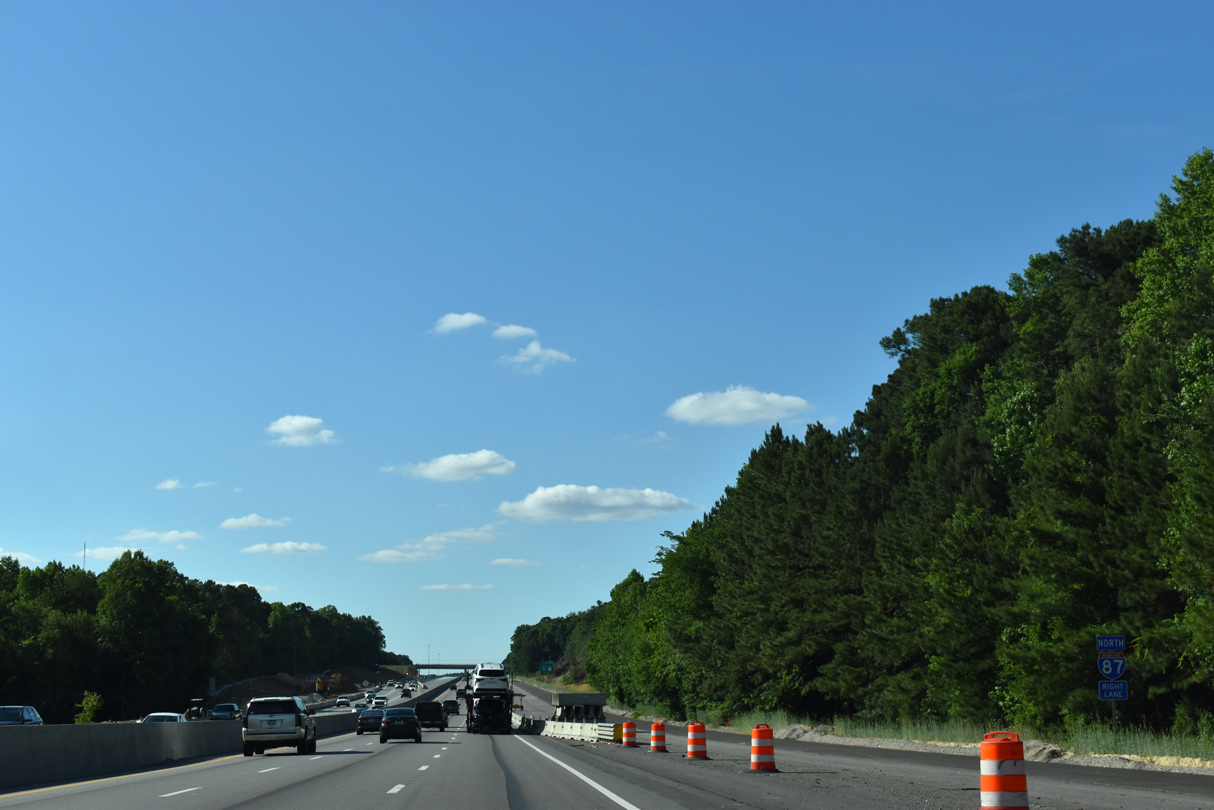
| Costing $330 million, widening of Interstate 40 between NC 42 and I-87/440 started in October 2018. The project through 2022 expands the freeway to eight overall lanes. 02/15/19 |
|
| I-40 converges with Jones Sausage Road at a diamond interchange (Exit 303). Jones Sausage Road continues north to Rocky Quarry Road (SR 2542) opposite S New Hope Road (SR 2697). 02/15/19 |
|
| Jones Sausage Road connects I-40 with Walnut Creek Park South and Coastal Credit Union Music Park via Rock Quarry Road west. 02/15/19 |
|
| 2018-23 widening of I-40 between Exit 303 and I-87/440 adds two lanes per direction. 05/31/21 |
|
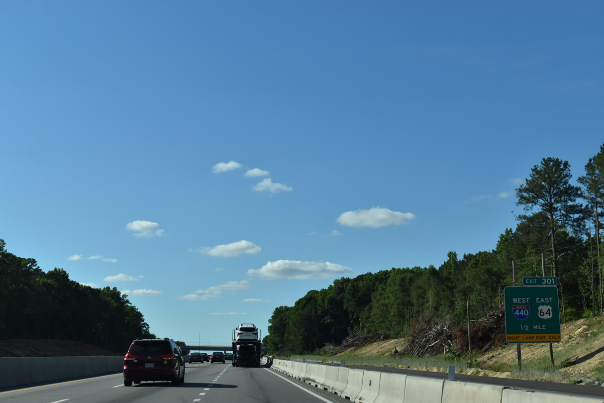
| Running north between the Providence and Dutchman Creek subdivisions, I-40 meets I-87/440 and U.S. 64 (Cliff Benson Beltline) at a directional T interchange (Exit 301). 05/31/21 |
|
| Approved by AASHTO in 2016, shields for I-87 along I-440 east / U.S. 64 west between Exit 301 and the Knightdale Bypass (U.S. 64/264) were posted in 2019. 05/31/21 |
|
| U.S. 64 combines with I-40 across the south side of Raleigh between I-440 at Exit 301 and U.S. 1 at Cary. I-440 combined with I-40 until late 2008 as well. 05/31/21 |
|
| Interstate 87 overlays U.S. 64 east 13.09 miles to Wendell. The Future I-87 corridor extends east along U.S. 64 to Williamston and north along U.S. 17 to Hampton Roads, Virginia. 05/31/21 |
|
| Interstate 440 (Cliff Benson Beltline) encircles Raleigh westward 16.82 miles from Southeast Raleigh to North Hills, Crabtree Valley and Southwest Raleigh. U.S. 64 travels east from Raleigh to Rocky Mount and the Outer Banks. 05/31/21 |
|
| The next nine interchanges along I-40 west, from I-87/440 to Wade Avenue (SR 1728), serve the city of Raleigh. 06/06/05 |
|
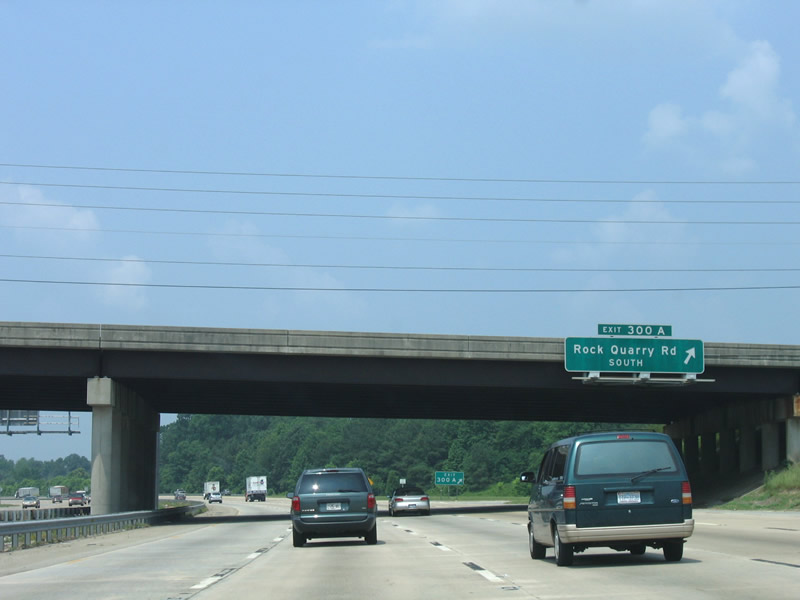
| Rock Quarry Road (SR 2542) curves northwest by the Southgate neighborhood to a parclo interchange (Exit 300) with I-40/U.S. 64. 06/06/05 |
|
| Exit 300B departs I-40/U.S. 64 west for Rock Quarry Road north to Battery Heights and the east side of Downtown Raleigh. 06/06/05 |
|
| Exit 300A loops onto Rock Quarry Road south to Sanderford Road (SR 2564). Rock Quarry and Sanderford Roads serve a bevy of subdivisions south and west of Interstate 40. 06/06/05 |
|
| Hammond Road (SR 2026) extends south from the couplet of Blount and Person Streets to I-40/U.S. 64 at Exit 299 and the town of Garner. 06/06/05 |
|
| Person Street (SR 2026) north from Hammond Road provides one of two routes from I-40 to the North Carolina State Capitol. Hammond Road constitutes a four to six lane arterial south to U.S. 70 in Garner. 01/02/08 |
|
| Continuously omitted on guide signs, Exit 298B connects I-40/U.S. 64 with U.S. 70/401-NC 50 north into Downtown Raleigh via S Saunders Street. The three were previously signed along the Raleigh freeway system at one point. 01/02/08 |
|
| U.S. 70/401-NC 50 (S Saunders Street) lead north through Carleigh, the Warehouse District and Downtown to the interchange joining Capital Boulevard with Wade Avenue west. 01/02/08 |
|
| U.S. 70 east, U.S. 401 south and NC 50 south follow S Saunders Street to Wilmington Street. U.S. 70/NC 50 split with U.S. 401 (Fayetteville Road) south to Fuquay-Varina in 1.61 miles at a wye interchange. 06/06/05 |
|
| An auxiliary lane accompanies I-40 west to the diamond interchange (Exit 297) with Lake Wheeler Road (SR 1009). 06/06/05 |
|
| Lake Wheeler Road angles northeast from Exit 297 to the North Carolina Farmers Market and S Saunders Street at the Warehouse District. 06/06/05 |
|
| I-40/U.S. 64 westbound markers posted south of Lonnie Poole Golf Course. 01/02/08 |
|
| Gorman Street (SR 1571) connects with I-40/U.S. 64 between Southwest Raleigh and parallel Tryon Road (SR 1009). 01/02/08 |
|
| The diamond interchange (Exit 295) with Gormon Street lies just west of the Trailwood Drive (SR 1348) overpass on I-40/U.S. 64. Gormon Street leads north to Avent Ferry Road (SR 1321) and Meredith College. 01/02/08 |
|
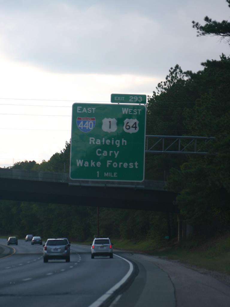
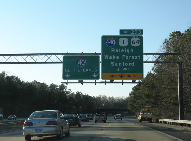
| I-40/U.S. 64 split at the cloverleaf interchange with I-440/U.S. 1.
Construction expanded the freeway from two to three through lanes by 2011. Subsequent widening underway from 2016-18 added an auxiliary lane westbound to the c/d roadway for Exit 293. 10/01/11 |
|
| Interstate 440 (Cliff Benson Beltline) overlaps with U.S. 1 north 10.73 miles to U.S. 401 (Capital Boulevard). U.S. 64 combines with U.S. 1 southwest to Cary and Apex. 01/02/08 |
|
| U.S. 1 constitutes a freeway southwest along the Claude E. Pope Memorial Highway to Sanford. U.S 64 heads west from Apex to Jordan Lake and Asheboro. I-440/U.S. 1 lead northeast toward Wake Forest. 01/02/08 |
|
| I-440/U.S. 1 arc northeast seven miles through Southwest Raleigh and Method to Wade Avenue at West Raleigh and U.S. 70/NC 50 at Crabtree Valley. 01/02/08 |
|
| Exit 293A loops onto U.S. 1/64 southwest into Cary. Once proposed as Interstate 340, U.S. 1 joins the Raleigh area with Sanford, Southern Pines, and Pinehurst along a four lane corridor. Sign changes made by 2011 replaced Sanford with Cary. 10/01/11 |
|
| Interstate 40 expands to ten lanes along the south side of William B. Ulmstead State Park, from Wade Avenue west to the diamond interchange (Exit 287) with Harrison Avenue (SR 1652). 06/06/05 |
|
| Exit 287 parts ways with Interstate 40 west for Harrison Avenue (SR 1652) south into the city of Cary and north into William B. Umstead State Park. 06/06/05 |
|
| Westbound Interstate 40 shield posted between Exit 287 and the Old Reedy Creek Road (SR 1795) overpass. The freeway passes just north of Lake Crabtree and Lake Crabtree County Park on the ensuing stretch. 06/06/05 |
|
| Aviation Parkway (SR 1002) curves northwest from forthcoming Exit 285 to John Brantley Boulevard to the passenger terminal at Raleigh Durham International Airport (RDU). 06/06/05 |
|
| 2018-20 construction at Exit 285 replaced the Aviation Parkway overpass and rebuilt the exchange into a six-ramp parclo interchange. Aviation Parkway continues southwest past Lake Crabtree to an industrial park area at Evans Road and NC 54 (Chapel Hill Road) at Morrisville. 06/06/05 |
|
| Crossing Stirrup Iron Creek, I-40 advances a half mile northwest to a cloverstack interchange (Exit 283) with Interstate 540 east and NC 540 west. 12/15/16 |
|
| Measuring 25.84 miles, Interstate 540 follows the Northern Wake Expressway across the north side of the Raleigh area from I-40/NC 540 to I-87/U.S. 64-264 at Knightdale. 12/15/16 |
|
| NC 540 runs along the Western Wake Expressway southwest 1.17 miles to NC 54 at Morrisville, where it becomes a toll road to the Triangle Expressway (TriEx). 12/15/16 |
|
| Exit 283 B separates from I-40 west just ahead of the Durham County line. I-540 (Northern Wake Expressway) connects with RDU Airport via Aviation Parkway, U.S. 70 at Briar Creek and U.S. 1 at North Raleigh. 12/15/16 |
Page Updated 01-20-2023.


 West
West


 West
West