|
| Interstate 65 crosses a series of eight bridges along the peninsula formed by the Alabama River. The spans pass over flood relief areas for the river. 10/09/16 |
|
| SR 143 ventures south from Millbook to end at Interstate 65 via a wye interchange (Exit 176 along I-65 north). A reassurance shield stands after the on-ramp. 10/09/16 |
|
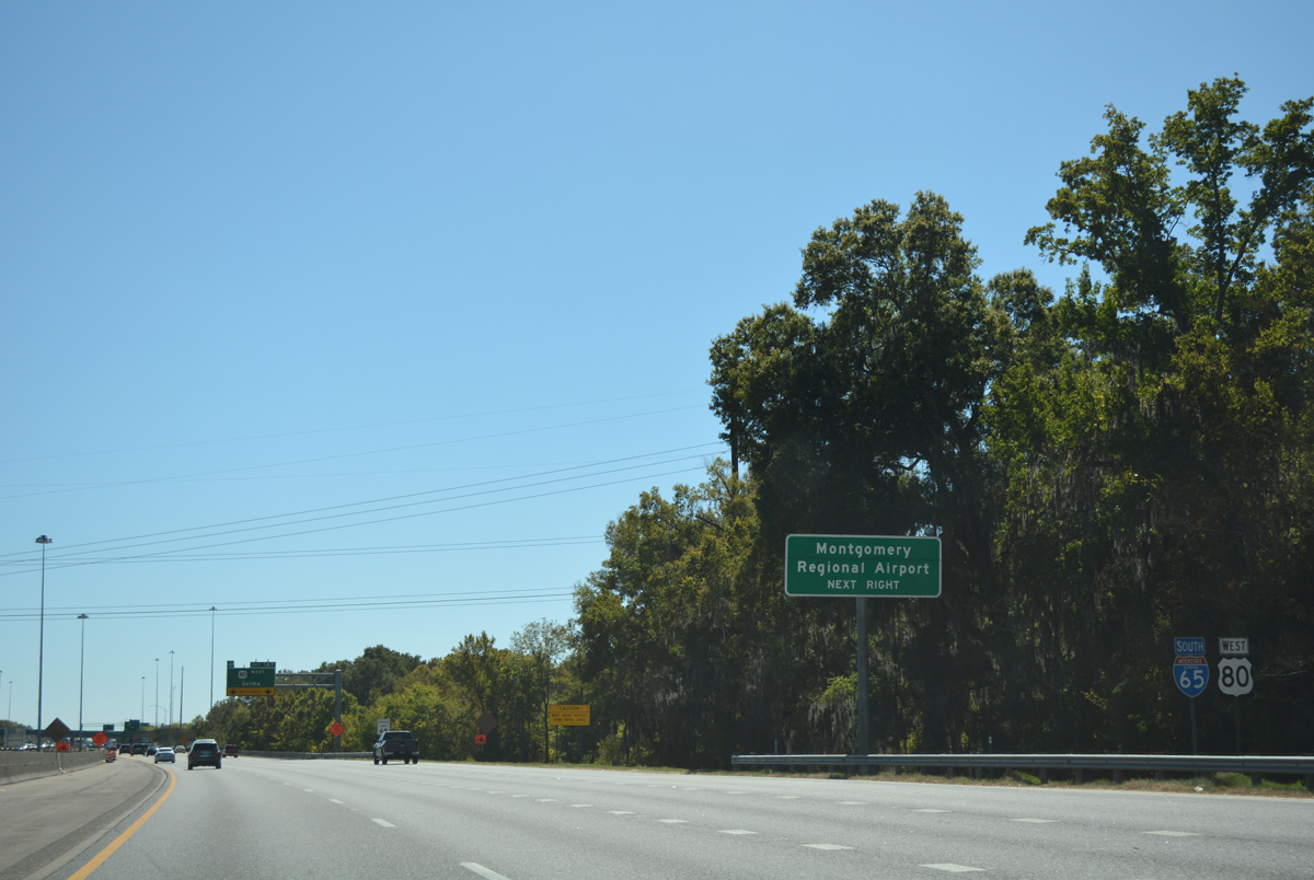
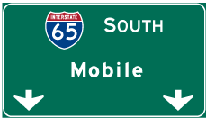
| Mobile, 182 miles away, appears for the first time on southbound distance signs for Interstate 65 on this assembly posted two miles out from North Boulevard (Exit 173) in Montgomery. 10/09/16 |
|
| An original button copy sign follows for the trumpet interchange (Exit 173) with North Boulevard (SR 152). SR 152 is the first of six Montgomery exits. 10/09/16 |
|
| Expansion of Interstate 65 to six overall lanes through Montgomery was completed in 2010. The freeway meets the south end of Interstate 85 in two miles.
I-85 presently begins in Montgomery and leads northeast to Auburn, Opelika and Atlanta. A western extension is proposed to continue the route to I-20/59 by way of the U.S. 80 corridor and Cuba. If the South Montgomery Bypass portion of I-85 is completed, the current stretch of I-85 east will become Interstate 685. AASHTO and FHWA approved the new designation in 2011.1 10/09/16 |
|
| Nearing the final Alabama River relief channel bridge along Interstate 65 south ahead of Exit 173. Interests to the state capitol are directed to use Herron Street east. 10/09/16 |
|
| Traffic to Maxwell Air Force Base is advised to use the split diamond interchange (Exit 173) with Clay and Herron Streets. Bell Street joins the central business district of Montgomery with the military base via Maxwell Boulevard to the west. 10/09/16 |
|
| SR 152, a 6.61 mile controlled access expressway east to U.S. 231 & SR 21 (Wetumpka Highway), begins at Exit 173 and crosses the Alabama River. Connections with U.S. 231 & SR 21 north lead drivers to Blue Ridge and the Elmore County seat of Wetumpka. North Boulevard also serves the State Farmer's Market and Maxwell A.F.B. Gunter Annex. 10/09/16 |
|
| A lone U.S. 82 shield stands within the trumpet interchange at Exit 173. The overlap with Interstate 65 is not acknowledged on pull through signs. 06/02/11 |
|
| Crossing the Alabama River, Interstate 65 gains an auxiliary lane from SR 152 to the Dickerson Street off-ramp (Exit 172) for Bell, Clay, Herron and Clayton Streets. Bell Street doubles an old alignment of U.S. 80 west from Downtown to Birmingham Highway (former U.S. 31). 10/09/16 |
|
| Expansion of the 1973-built Alabama River bridges added an inside lane in each direction, joining the previously separate spans with a barrier median. This Clay Street overhead predates the 2011 sign changes made to include Herron Street for Exit 172. Clay and Herron Streets form a one way street couplet from Oak Street nearby to Bibb Street in Downtown. 10/09/16 |
|
| Exit 172 leaves I-65 south from the south end of the Alabama River bridge with two lanes to Clay Street west and Herron Street east. The directional cloverleaf interchange with Interstate 85 north and the Day Street Connector west follows in one half mile. I-85 travels 672 miles north to Petersburg, Virginia by way of Atlanta, Georgia; Greenville and Spartanburg, South Carolina; Charlotte, Greensboro and Durham, North Carolina. 10/09/16 |
|
| Day Street leads west from the freeway network to Maxwell A.F.B. and Birmingham Highway (old U.S. 31). The connector is only accessible from southbound Interstate 65 and Interstate 85. 10/09/16 |
|
| Interstate 65 south & U.S. 82 east expand to four lanes to the two lane off-ramp (Exit 171) for Interstate 85 north. Construction of a 3.5 mile section of the Montgomery outer loop bypass, from I-85 south to SR 110 commenced on September 28, 2011. The first leg of the future Interstate 85 extension west to Selma and Cuba opened to traffic in January 2016. 10/06/16 |
|
| The on-ramp from Dickerson Street adds a second auxiliary lane for I-65 north to I-85 and the Day Street connector. Interstate 85 ventures east from Exit 171 to Mt. Meigs outside Montgomery. U.S. 80 joins the route from East Boulevard to Waugh (Exit 16). 10/06/16 |
|
| Traffic to both Interstate 85 and Day Street depart in unison from Interstate 65 south & U.S. 82 east. Interstate 85 travels 80.00 miles northeast through Atlanta, connecting the capital city with Auburn and Opelika before crossing the Chattahoochee River into Georgia by Lanett. 10/06/16 |
|
| A parting shot of the ramp partition at Exit 171 for Interstate 85 (Martin Luther King, Jr. Expressway) north and Day Street Connector west. 06/02/11 |
|
| Fairview Avenue, another former alignment of U.S. 80, meets Interstate 65 south & U.S. 82 east at the enusing exit. 10/09/16 |
|
| Passing through the three level interchange with Interstate 85 and the Day Connector along Interstate 65 south & U.S. 82 east. 10/09/16 |
|
| Motorists merging onto Interstate 65 south & U.S. 82 east from Interstate 85 south form an auxiliary lane to the diamond interchange (Exit 170) with Fairview Avenue. Fairview Avenue leads east to Huntingdon College and southwest to U.S. 31 & SR 21 (Mobile Highway). 10/09/16 |
|
| Early Street passes over Interstate 65 south & U.S. 82 east, one quarter mile north of Exit 170. Fairview Avenue was redesignated U.S. 80 Alternate by 1974 to the one way couplet of Perry / Hull Streets (former Alternate U.S. 231 and U.S. 331). 10/09/16 |
|
| Reassurance shields assembly posted ahead of the Stephens Street pedestrian overpass. Speed limits on I-65 were increased to 60 mph from 50 mph after construction was completed in 2010 along this stretch. 10/09/16 |
|
| A two lane ramp (Exit 170) leaves the southbound freeway for Fairview Avenue. Fairview Avenue remained within the state highway system as SR 21 to Norman Bridge Road (historic U.S. 331) until 1985. 10/09/16 |
|
| A half diamond interchange (Exit 169) quickly follows along Interstate 65 south & U.S. 82 east with Edgemont Avenue east to the Edgemont Heights neighborhood of the city. 06/02/11 |
|
| Edgemont Avenue ventures east from Exit 169 to Audubon Road, where the street changes names to Glen Grattan Drive en route to Woodley Road (former U.S. 82 & 231). 10/09/16 |
|
| This set of shields stands ahead of the CSX Railroad underpass. 10/09/16 |
|
| U.S. 82 parts ways with Interstate 65 south at South Boulevard (Exit 168) in one mile. Constructed in the early-60s in conjunction with East and North Boulevards, South Boulevard was originally intended to circumvent traffic away from Downtown Montgomery. With no access control measures in place, development eventually overtook the highway. 10/09/16 |
|
| One half mile ahead of the diamond interchange (Exit 168) with South Boulevard on I-65 south & U.S. 82 east. 10/09/16 |
|
| South Boulevard doubles as U.S. 80 and SR 21 between U.S. 31 nearby (Mobile Highway / West Boulevard) and East Boulevard (U.S. 80 east & U.S. 231-SR 21 north). U.S. 82 follows the arterial 5.48 miles east to Troy Highway, where it merges with U.S. 231 south. 10/09/16 |
|
| Two lanes leave Interstate 65 south for U.S. 80 & 82 east and South Boulevard. SR 21 turns south with U.S. 31 (Mobile Highway) at West Boulevard to U.S. 80 (Selma Highway). The state route joins the Montgomery area with the Lowndes County seat of Hayneville. U.S. 82 leaves the metropolitan area for Union Springs and Eufaula while U.S. 331 begins 1.58 miles east of Exit 168 and follows South Court Street to Wiley. U.S. 331 stays east of Interstate 65 to Luverne and Opp. 10/09/16 |
|
| U.S. 80 west accompanies Interstate 65 from South Boulevard to Exit 167. Prior to 1992, the US route followed South Boulevard west to overlap with U.S. 31 south. 06/02/11 |
|
| U.S. 80 combines with I-65 south for 1.11 miles. West from Exit 167, the US highway heads to Montgomery Regional Airport (MGM). 10/09/16 |
|
| Spanning Catoma Creek, one third of a mile north of the semi directional T interchange with the U.S. 80 freeway west to U.S. 31 & SR 21. 10/09/16 |
|
| Southbound traffic partitions for I-65 to Mobile and U.S. 80 west. U.S. 80 comprises a four lane divided highway west 45 miles to Selma and 97 miles to Demopolis. Portions of the roadway are expressway grade with interchanges. U.S. 80 joins the Interstate 20 corridor at Meridian and follows it west to Mesquite, Texas. 10/09/16 |
|
| Beyond the Southlawn subdivision abutting the west side of I-65 near Exit 167, the freeway becomes rural and stays that way until Satsuma in Mobile County. 10/09/16 |
|
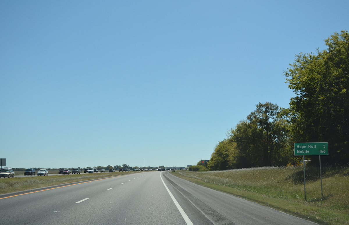
| The subsequent exit of Interstate 65 south lies three miles ahead at Hope Hull. The distance to Mobile is 166 miles, two miles longer then the remainder of the freeway to Interstate 10. 10/09/16 |
|
| Connections via U.S. 31 (Mobile Highway) north from Exit 164 lead motorists to Montgomery County 42 (Hyundai Boulevard / former Teague Road). CR 42 constitutes a 3.5 mile link with U.S. 331 (Norman Bridge Road) and Hyundai manufacturing plant opened on May 20, 2005. Construction of the plant also coincided with widening of U.S. 31, County Road 42, and U.S. 331. 07/11/10 |
|
| Approaching the Hyundai Boulevard overpasses on Interstate 65 south, one mile out from the diamond interchange with Exit 164 (U.S. 31). 10/09/16 |
|
| Exit 164 represents the last time that U.S. 31 directly interacts with Interstate 65. Southward to Baldwin County, U.S. 31 stays east of the freeway through Greenville, Georgiana and Evergreen. 10/09/16 |
|
| Interstate 65 reaches the off-ramp (Exit 164) to U.S. 31 (Mobile Highway) at Hope Hull. Pintlala lies seven miles to the south. 10/09/16 |
|
| Construction in 2003 expanded the off-ramp at Exit 167 to accommodate increasing truck traffic for an adjacent industrial park along Folmar Parkway and south of County Road 42 (Wasden Road). A truck stop occupies land southeast of the interchange as well. 06/02/11 |
|
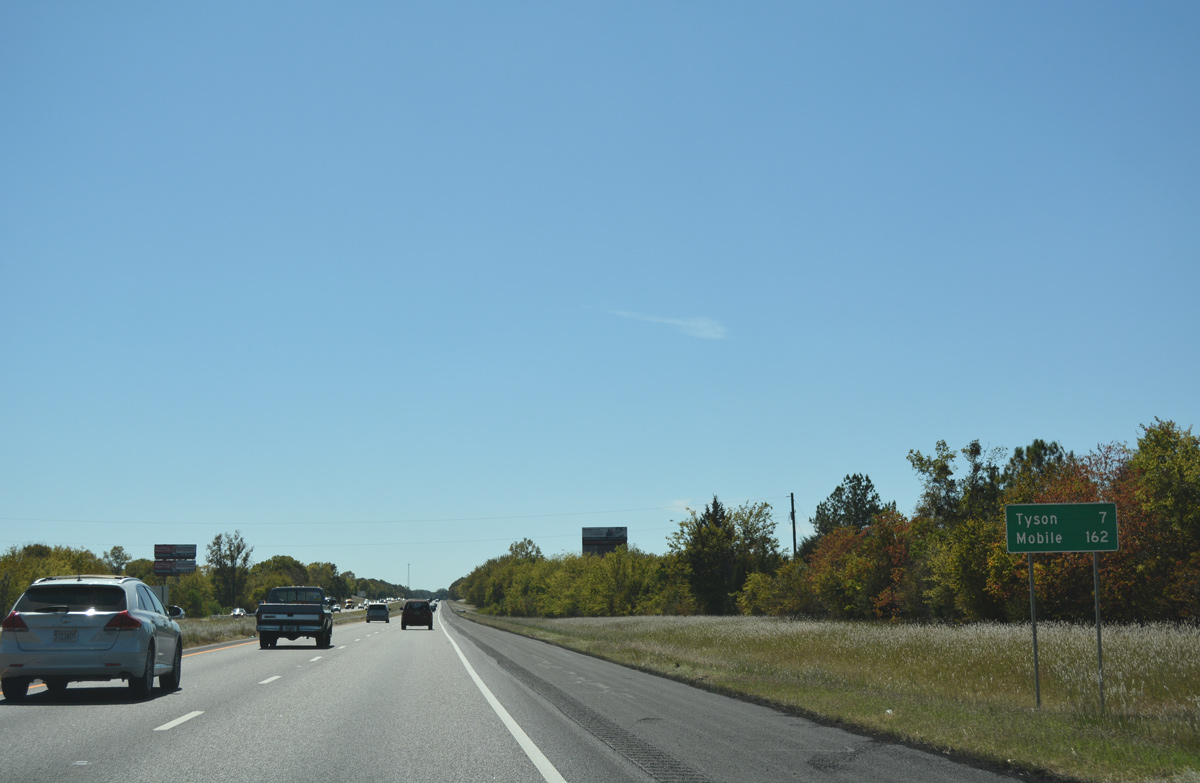
| Advancing southwest from Hope Hull, Interstate 65 travels across Pintlalla Creek toward settlement of Tyson in seven miles. Mobile is now 162 miles away. 10/09/16 |
|
| One mile north of the diamond interchange (Exit 158) with CR 6 (Tyson Road) on Interstate 65 south. The original concrete along this stretch was paved over with asphalt in fall 2001. 10/09/16 |
|
| Interstate 65 travels 17.94 miles south through Montgomery County to Lowndes County. 10/09/16 |
|
| Signs for Exit 158 omit both Lowndes County 6 west to Tyson and Montgomery County 24 (Cloverfield Road) east to Pintlala. CR 24 overtakes Federal Road east across Pinchony Creek to intersect U.S. 31 in 3.5 miles. 10/09/16 |
|
| Exit 158 departs Interstate 65 south for County Road 6 (Tyson Road). CR 6 connects with CR 26 west to nearby Tyson and the county seat of Hayneville. 10/09/16 |
|
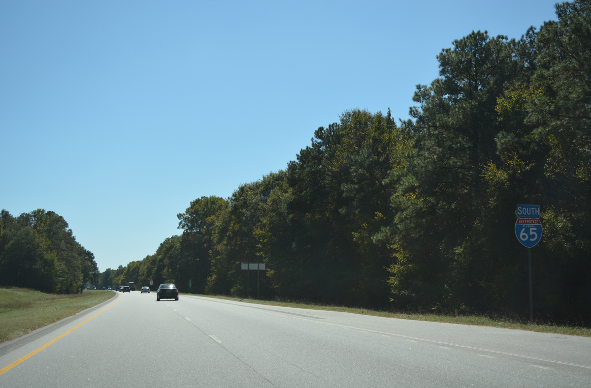
| Reassurance shield and distance sign posted for Interstate 65 south on the eight mile drive to Letohatchee. There are no major cities between Montgomery and Mobile otherwise. 10/09/16 |
|
| SR 97 crosses paths with Interstate 65 at a diamond interchange (Exit 151) in one mile. 10/09/16 |
|
| A 29.80 mile route, SR 97 arcs northwest from U.S. 331 near Highland Home to Hayneville and U.S. 80 at Lowndesboro. 10/09/16 |
|
| North from Exit 151, SR 97 travels 8.96 miles through Letohatchee to SR 21 at the town of Hayneville. 10/09/16 |
|
| Exit 151 separates from the I-65 southbound mainline for SR 97. Continuing south, SR 97 leads 4.26 miles to merge with U.S. 31 to the settlement of Davenport. 10/09/16 |
|
| Interstate 65 sees a number of long exit less stretches through Lower Alabama. Fort Deposit lies 12 miles ahead via Exit 142 in 9.2 miles. 10/09/16 |
|
| SR 185 begins at the settlement of Logan from U.S. 31 and heads west 2.5 miles to Interstate 65 at Exit 142. 10/09/16 |
|
| SR 185 comprises a 23.13 mile loop west to the town of Fort Deposit and south to the city of Greenville. Fort Deposit was established in 1813 as a supply depot by General Ferdinand Claiborne during the Creek Indian War. Settlers homesteaded at Fort Deposit following the conflict, and by 1855 a post office was established.2 10/09/16 |
|
| Entering the rural diamond interchange (Exit 142) with SR 185 east to U.S. 31 and west to Fort Deposit. U.S. 31 parallels I-65 to the east from Logan south to Spring Hill and Greenville. 10/09/16 |
|
| Interstate 65 sees another forested roadway split as it leaves Exit 130 on the 13 mile drive to Greenville. Mobile is now 140 miles to the southwest. 10/09/16 |
|
| The 18.74 section of Interstate 65 within Lowndes County concludes as the freeway crosses into Butler County ahead of the Fort Deposit Road overpass. 10/09/16 |
Page Updated 05-16-2017.

 South
South  East
East


 West
West