|
| Interstate 70 converges with a flyover from I-64 west as both ramps elevate above a pair of railroad lines. 05/07/18 |
|
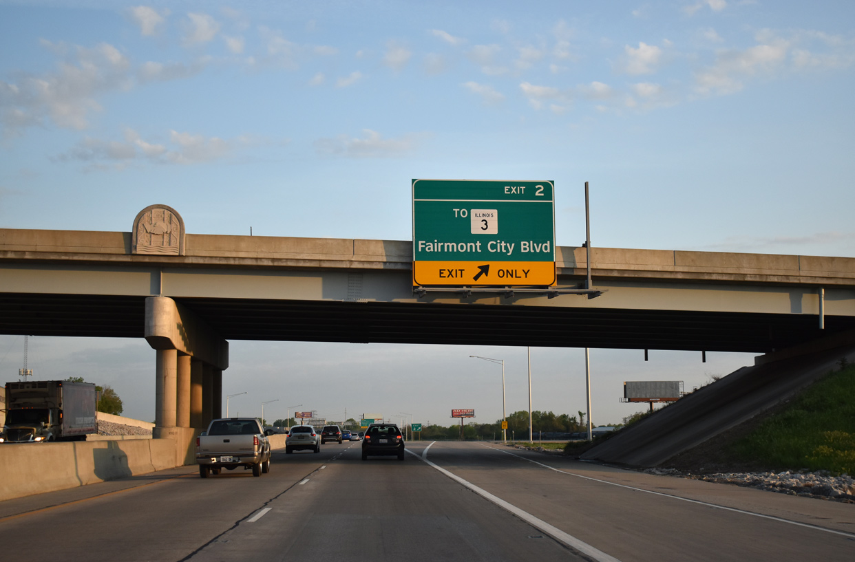
| Advancing northwest with two lanes, Interstate 70 approaches a parclo interchange (Exit 2) with Fairmont City Boulevard and Packers Avenue. 05/07/18 |
|
| Route 3 parallels the west side of I-70 along St. Clair Avenue by industrial areas of north East St. Louis. Packers Avenue links Exit 2 with the state route from Fairmont City Boulevard south. 05/07/18 |
|
| Exit 2 curves east onto adjacent Fairmont City Boulevard as Packers Avenue spans Interstate 70. Route 3 continues north onto 2nd Street through the village of Brooklyn. 05/07/18 |
|
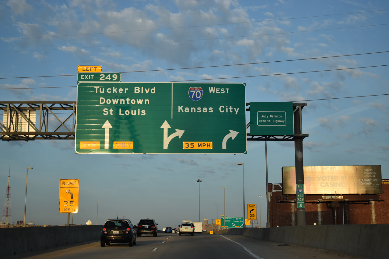
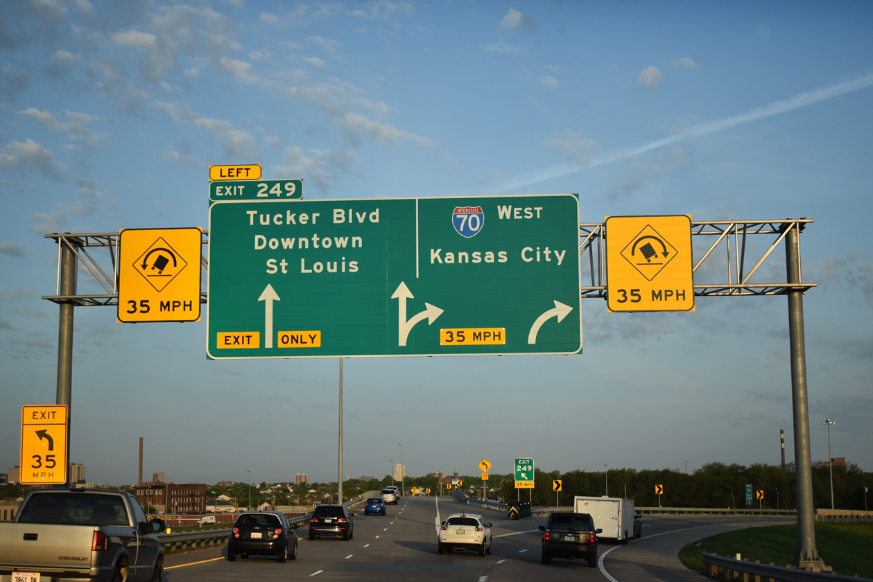
| Interstate 70 makes a sweeping curve onto the Stan Musial Veterans Memorial Bridge. A two-wye interchange (Exit 249) joins the west end of the bridge with Tucker Boulevard south to Downtown St. Louis. 05/07/18 |
|
| Named after St. Louis Cardinals Hall of Famer Stan Musial. and honoring military veterans, the I-70 bridge across the Mississippi River opened to traffic on February 9, 2014. The westbound lanes opened at 10:20 AM, followed by the eastbound direction by noon.1 05/07/18 |
|
| The new ramps linking Interstate 70 with Tucker Boulevard were constructed as part of the $695 million project to build the Stan Musial Veterans Memorial Bridge.2 Tucker Boulevard extends south from I-70 between the Carr Square and Columbus Square neighborhoods toward Downtown St. Louis. 05/07/18 |
|
| A pair of 400 foot towers support the 1,500-foot main span of the Stan Musial Veterans Memorial Bridge.2 05/07/18 |
|
| Travelers along Interstate 70 westbound formally enter the independent city of St. Louis, Missouri by the west tower of the Stan Musial Veterans Memorial Bridge. 05/07/18 |
|
| When it opened, the Stan Musial Veterans Memorial Bridge was the third longest cable-stayed bridge in the United States.1 05/07/18 |
|
| Interstate 70 elevates over St. Louis Riverfront Trail, 1st Street and North Broadway to the left exit for Tucker Boulevard south. The freeway mainline turns north with two lanes at Exit 249. 05/07/18 |
|
| Westbound Interstate 70 partitions with Exit 249 and Tucker Boulevard south to Downtown St. Louis. There is no access to I-44 west, which follows former I-70 between the central business district and Jefferson National Expansion Memorial. 05/07/18 |
|
| Interstate 44 ends at the Great Rivers Greenway overpass as I-70 overtakes the freeway northward along the Old North St. Louis and Hyde Park neighborhoods. 05/07/18 |
|
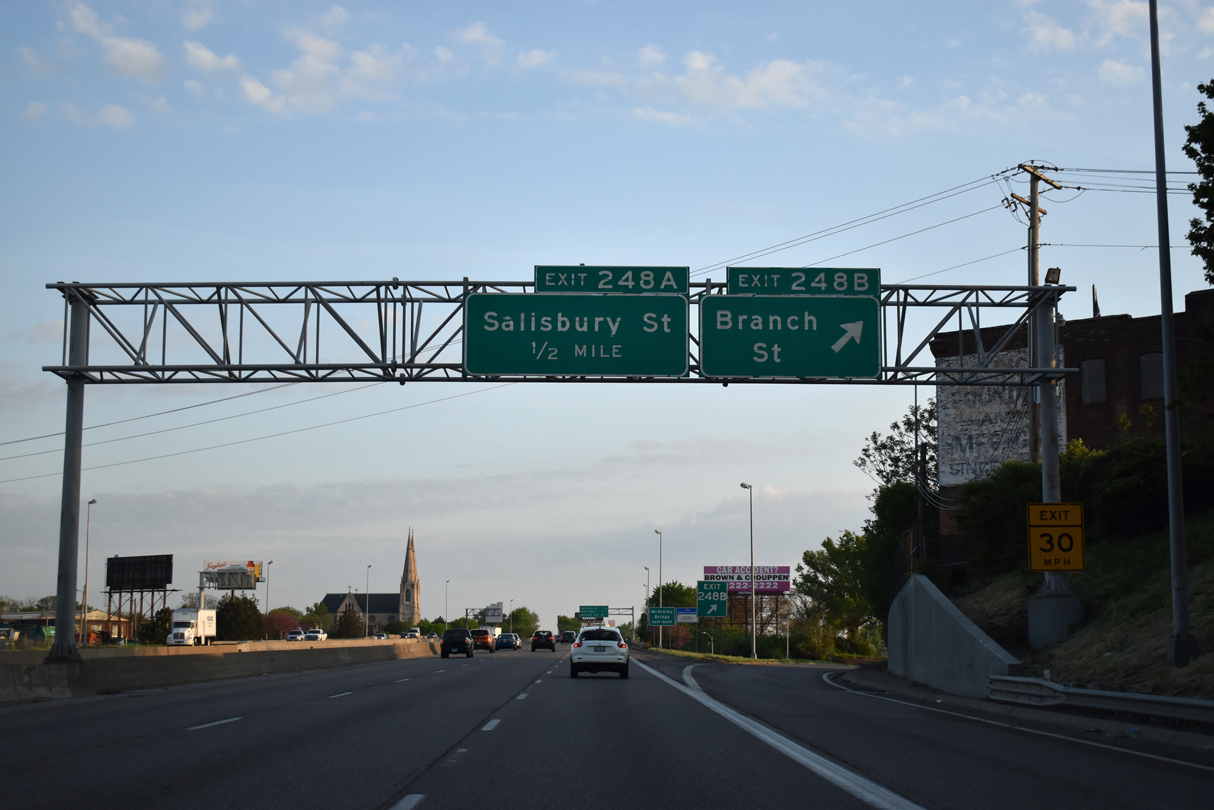
| Interstate 70 continues north one half mile to a half diamond interchange (Exit 248B) with Branch Street. 05/07/18 |
|
| An entrance ramp joins I-70 west from parallel 10th Street at Market Street. The freeway advances northwest 0.75 miles to Salisbury Street (Route 115 west) and 1.5 miles to Grand Boulevard at College Hill.
Visible to the left are the eastbound I-70 Express Lanes. 05/07/18 |
|
| Exit 248B partitions with ramps for Branch Street west to Natural Bridge Road and east to Broadway. Route 115 follows Natural Bridge Avenue west from Salisbury Street to Jeff Vanderlou and Fairground Park. 05/07/18 |
|
| Forthcoming Exit 248A joins parallel 9th Street ahead of both Salisbury Street (Route 115) west and the Mc Kinley Bridge east to IL 3. Dedicated in 1910, the Mc Kinley Bridge supported a railroad line until 1977. The steel truss span was closed in 2001 and rehabilitated between 2005 and its reopening in 2007.3 05/03/12 |
|
| Interstate 70 curves westward from Grand Boulevard (Exit 247) at College Hill to O'Fallon Park (Exit 246B) over the next two miles. 05/07/18 |
|
| Salisbury Street west from 9th Street and the Mc Kinley Bridge carries Route 115 to Natural Bridge Avenue. Natural Bridge Avenue takes the state highway northwest to exit the city by the Wells Goodfellow neighborhood. I-70 meets Route 115 again at Exit 237. 05/07/18 |
|
| An IL 3 trailblazer references the McKinley Street Bridge east to the state route in the city of Venice. 05/07/18 |
|
| Passing over Angelica Street, Interstate 70 gains a lane from the 9th Street on-ramp to the diamond interchange (Exit 247) with Grand Boulevard. 05/03/12 |
|
| North Broadway parallels the east side of Interstate 70 directly from Grand Boulevard (Exit 247) to Exit 246A by O'Fallon Park. 05/03/12 |
|
| Exit 247 leaves Interstate 70 west for Grand Boulevard. Grand Boulevard leads southward throughout the city to Fairground Park, Jeff Vanderlou and Carondelet in south St. Louis. The street becomes Grand Avenue east of adjacent Broadway to Hall Street. 05/03/12 |
|
| A diamond interchange (Exit 246B) joins Interstate 70 with Adelaide Avenue in one quarter mile. The freeway lines the east side of O'Fallon Park from Adelaide Avenue to Florissant Avenue (Exit 245B). 05/03/12 |
|
| Adelaide Avenue connects I-70 with the O'Fallon community to the west and North Riverfront to the east. A direct ramp (Exit 246A) joins North Broadway ahead of Carrie Avenue in one half mile. 05/03/12 |
|
| Interstate 70 turns more westerly from North Broadway to the Mark Twain community (Exit 245B) and the Penrose community (Exit 245A) over the next 1.25 miles. 05/03/12 |
|
| North Broadway and Interstate 70 diverge from O'Fallon Park northward. North Broadway continues to the North Riverfront and Baden communities to exit the city as Bellefontaine Road into Bellefontaine Neighbors. 05/03/12 |
|
| Two lanes depart Interstate 70 west for Exit 246A. Broadway intersects Carrie Avenue south into O'Fallon Park and east to North Riverfront as part of the modified diamond interchange with I-70. Historically North Broadway was a part of U.S. 66 Business between Calvary Avenue and Riverview Drive. 05/03/12 |
|
| Three off-ramps depart over the course of one mile from I-70 west culminating with Exit 244B to Kingshighway at Penrose Park. 05/03/12 |
|
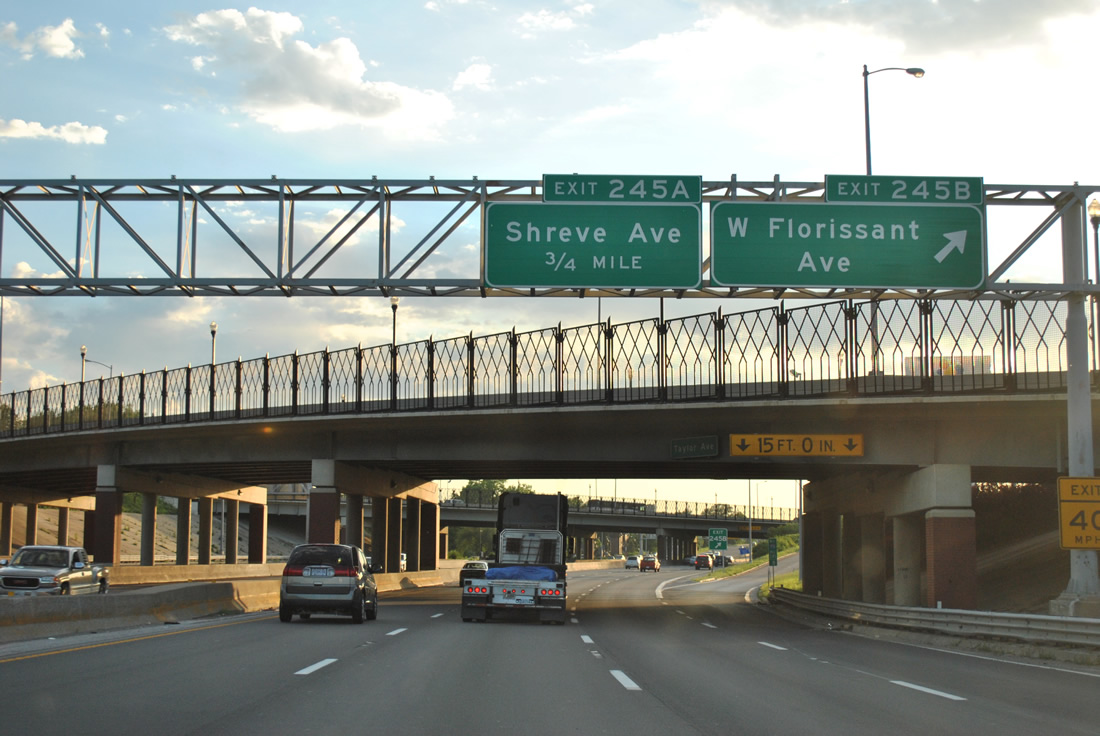
| Taylor Avenue spans I-70 west at Exit 245B to Florissant Avenue. Florissant Avenue extends north from the O'Fallon neighborhood by both Bellefontaine and Calvary Cemeteries through the Mark Twain and Walnut Park East communities to the city of Jennings. 05/03/12 |
|
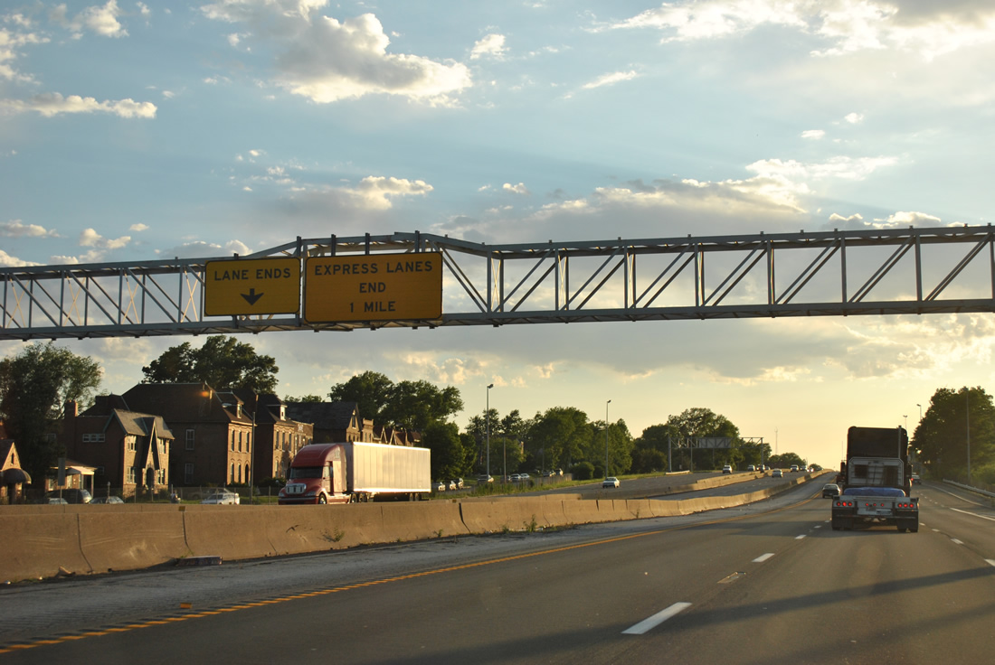
| The Express Lanes conclude one mile to the north beyond the Union Boulevard overpass, leaving I-70 with six overall lanes to the St. Louis County line. 05/03/12 |
|
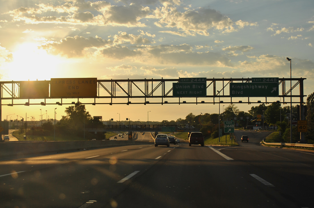
| Exit 245A to Shreve Avenue leaves in one quarter mile, followed by a half diamond interchange (Exit 244B) with Kingshighway Boulevard and a diamond interchange (Exit 244A) with Union Boulevard. 05/03/12 |
|
| Shreve Avenue stems west from Florissant Avenue through Mark Twain to Exit 245A. South of I-70, Shreve Avenue continues through Penrose to Route 115 (Natural Bridge Avenue) at Kingsway East. 05/03/12 |
|
| I-70 crosses over a Southern Pacific Railroad line ahead of Exit 244B for Kingshighway Boulevard. Exit 244B forms the beginning of Bircher Boulevard north, an east side frontage road providing access from I-70 west to both Exit 244A for Union Boulevard and Riverview Boulevard (Route 367 north). 05/03/12 |
|
| Kingshighway Boulevard south from Bircher Boulevard represents the former alignment of both U.S. 67 and U.S. 40 Alternate. U.S. 67 took Kingshighway south to Central West End, Forest Park and Gravois Avenue (Route 30) at Bevo Mill. U.S. 67 followed Riverview Boulevard north from Bircher to Halls Ferry Circle. 05/03/12 |
|
| The interchange sequence sign at Kingshighway outlines the final three exits in the city of St. Louis. 05/03/12 |
|
| Union Boulevard provides one of two exits from Interstate 70 west into the adjacent Mark Twain I-70 Industrial area to the west. Exit 244A parts ways with the westbound freeway opposite the eastbound beginning of the Express Lanes. 05/03/12 |
|
| The slip ramp from Bircher Boulevard onto Interstate 70 west from Union Boulevard forms an auxiliary lane to the diamond interchange (Exit 243A) with Goodfellow Boulevard. 05/03/12 |
|
| Goodfellow Boulevard rounds out the St. Louis city exits at the Walnut Park West neighborhood. Exit 242 with Jennings Station Road at Pine Lawn and Jennings follows. 05/03/12 |
|
| Riverview Boulevard north from parallel Bircher Boulevard doubles as Route 367. Route 367 travels 8.99 miles from I-70 north to Bellefontaine Neighbors, Moline Acres and the north end of Lindbergh Boulevard (U.S. 67). 05/03/12 |
|
| Goodfellow Boulevard parallels the St. Louis County line north from Exit 243A to North Pointe and Halls Ferry Circle. 05/03/12 |
|
| Exiting the city, Interstate 70 winds between the cities of Pine Lawn, Northwoods and Jennings to Highway U (Lucas & Hunt Road) at Exit 241B. 05/03/12 |
|
| South from Exit 243A, Goodfellow Boulevard travels by the former St. Louis Ammunition Plant. Built in 1941, the site produced munitions until 1969 and was retained for use by military reserve units until 1998.4 05/03/12 |
|
| A parclo interchange (Exit 242) joins Interstate 70 with Jennings Station Road one quarter mile west of Goodfellow Boulevard. 05/03/12 |
Page Updated 05-11-2018.

 West
West