|
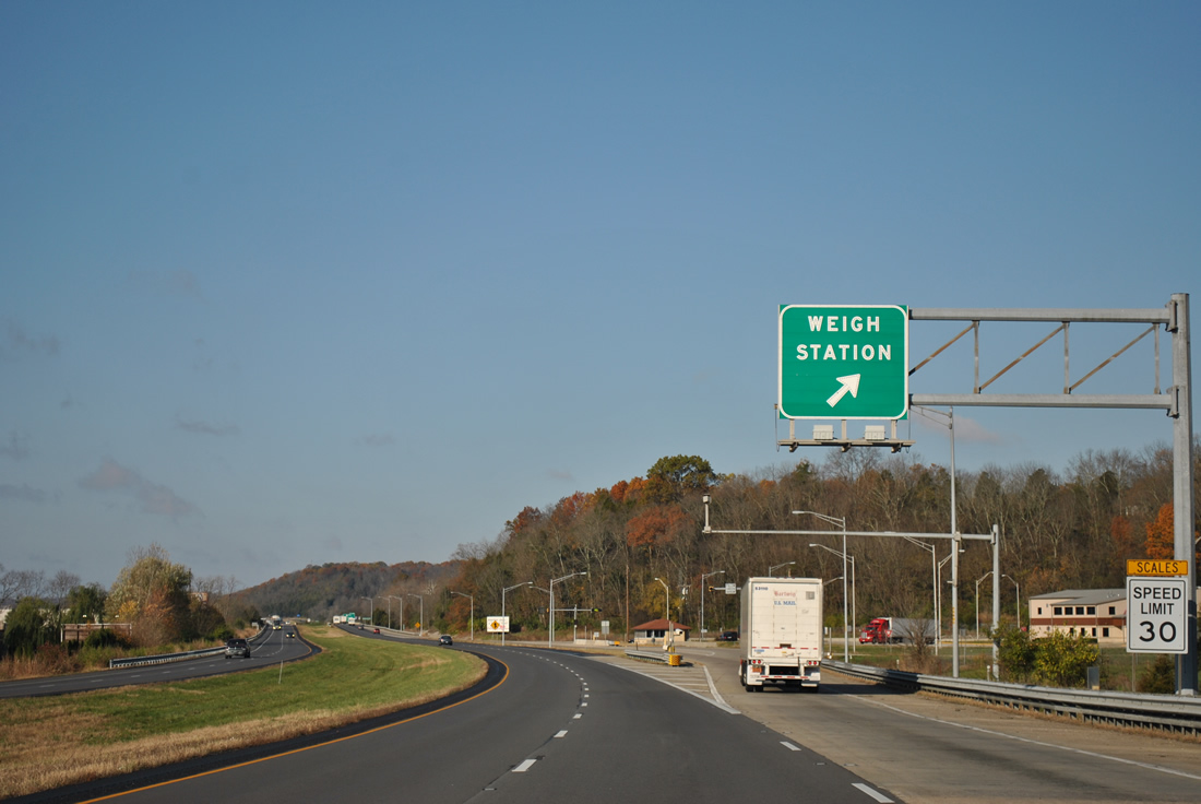
| I-74/U.S. 52 continue their shared mileage from Interstate 75 in Cincinnati to Dearborn County, Indiana. The pair pass over Stout Road and Cooper Run ahead of a westbound side weigh station facility for commercial trucking interests. 11/04/11 |
|
| I-74/U.S. 52 line a plain parallel to old U.S. 52 (Harrison Brookville Road) and the Whitewater River between hills to the north and south. The westbound side weigh station resides ahead of Johnson Fork. 11/04/11 |
|
| A set of reassurance markers for I-74/U.S. 52 follow the weigh station and adjacent Johnson Fork Road underpass. 11/04/11 |
|
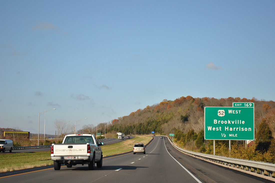
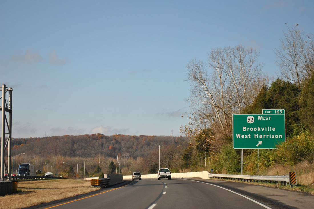
| U.S. 52 west returns to its original alignment from Interstate 74 west at Exit 169 (Harrison Brookville Road) in one mile. Harrison Brookville Road east connects the freeway with West Harrison. 11/04/11 |
|
| Venturing northwest, U.S. 52 crosses the Franklin County line near Braysville for New Trenton, Cedar Grove, the county seat of Brookville and Metamora. 11/04/11 |
|
| Exit 169 loops north from Interstate 74 west to Harrison Brookville Road. U.S. 52 meets the east end of SR 46 nearby, as SR 46 begins and parallels I-74 west to Saint Leon, Batesville and Greensburg. U.S. 52 meanwhile veers away from the freeway corridor to Rushville and New Palestine before joining the Indianapolis Beltway. 11/04/11 |
|
| Westbound drivers span the Whitewater River immediately west of Exit 169. A reassurance marker proceeds the 1962-built bridges. 11/04/11 |
|
| Saint Leon represents the next exit in six miles. Indianapolis follows in 80 miles. 11/04/11 |
|
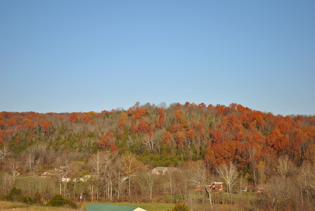
| Interstate 74 slices through hills south of Logan Creek in northern Dearborn County. The hilly landscape gives way to open farm land on the drive to Indianapolis. 11/04/11 |
|
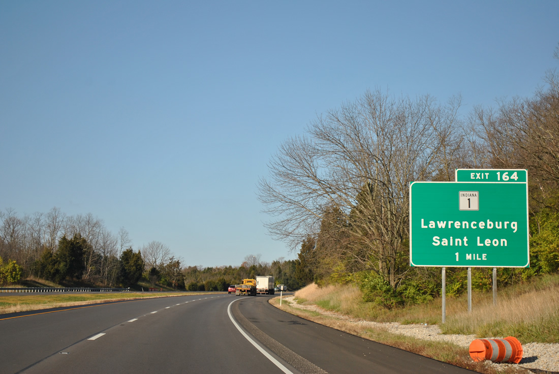
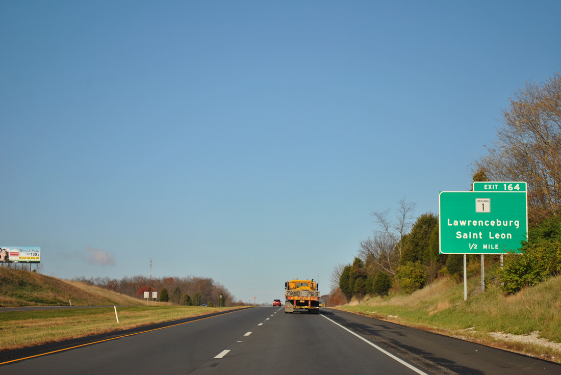
| Crossing paths with Interstate 74 next is SR 1, a two-segment route stretching 139.8 miles from Lawrenceburg to Fort Wayne and for 40.7 miles between Fort Wayne and Ellis. 11/04/11 |
|
| One mile east of the Exit 164 diamond interchange with SR 1 on Interstate 74 west. SR 1 leads 15.3 miles southeast through Dover to end at U.S. 50 in Lawrenceburg. 11/04/11 |
|
| North from SR 46 in adjacent Saint Leon, SR 1 continues 6.3 miles to merge with U.S. 52 west near Cedar Grove to Brookville. SR 1 continues from there to Connersville. 11/04/11 |
|
| Curving northward briefly, Interstate 74 and SR 46 swap sides as the freeway enters agricultural areas to Lawrenceville. 11/04/11 |
|
| Posted at the SR 46 overpass is a westbound distance sign 10 miles from Sunman (SR 101), 15 miles from Batesville (Exit 149) and 76 miles from the capital city. 11/04/11 |
|
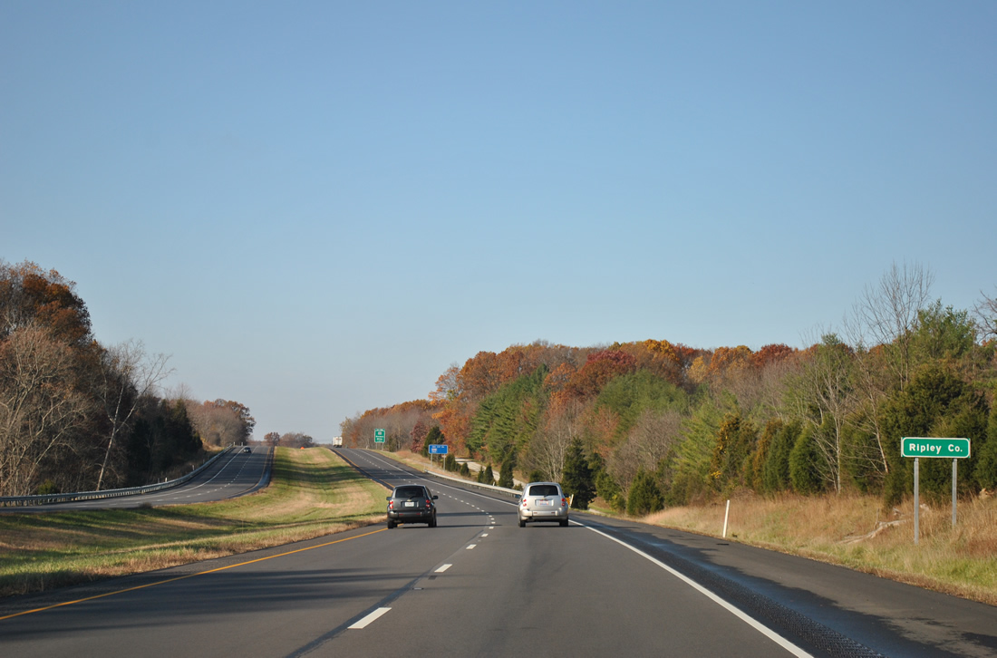
| Resuming a westward course, Interstate 74 enters its second county in Indiana, that of northeastern Ripley County. 11/04/11 |
|
| SR 101 north and St. Mary Road south come together at the Exit 156 diamond interchange with Interstate 74 in one mile. 11/04/11 |
|
| Consisting of three segments, SR 101's southern portion connects Interstate 74 with Sunman, Milan and U.S. 50 along a 17.5 mile route. Two other sections exist to the north: Brookville to Liberty (16.5 miles) and SR 124, east of Monroe, to SR 1 northeast of Fort Wayne (45 miles). 11/04/11 |
|
| Westbound Interstate 74 at the Exit 156 ramp departure to SR 101 south and St. Mary Road north. Penntown (SR 46) resides nearby. St. Mary Road north otherwise splits with Rosfeld Road to Pine Road near the settlement of St. Peter. 11/04/11 |
|
| Interstate 74 arcs northwesterly to Batesville on the remaining six mile drive through Ripley County. Shelbyville and Indianapolis are 41 and 68 miles away respectively. 11/04/11 |
|
| The first westbound rest area of Interstate 74 lies ahead of Batesville in two miles. The next facility is not located until beyond the Indianapolis metropolitan area. 11/04/11 |
|
| Interstate 74 curves more northerly, bypassing the nearby town of Morris ahead of the westbound rest area. 11/04/11 |
|
| Westbound at the rest area off-ramp; an eastbound side facility is situated a half mile to the west. 11/04/11 |
|
| Continuing west along Interstate 74 one mile to the diamond interchange (Exit 149) with SR 229 (Walnut Street south). 11/04/11 |
|
| SR 229 travels 21 miles overall between U.S. 421 at Napoleon to the south and U.S. 52 near Metamora to the north. 11/04/11 |
|
| Exit 149 departs Interstate 74 west for SR 229. Heading north, SR 229 leaves a commercial strip surrounding the freeway on a 2.6 mile drive to Oldenburg. Walnut Street carries the state route south to downtown Batesville and a one block dog leg of Boehringer Street to Main Street. 11/04/11 |
|
| Interstate 74 nips the southwestern corner of Franklin County from within Exit 149 to the County Line Road underpass near milepost 144.5. 11/04/11 |
|
| New Point represents the first of three Decatur County exits of Interstate 74 west in six miles. Shelbyville is 35 miles to the northwest. 11/04/11 |
|
| Spanning Little Laughery Creek on the north side of Batesville along Interstate 74 west. This stretch of freeway was completed in 1962. 11/04/11 |
|
| Entering Decatur County, the four county of Interstate 74 westbound in Indiana. 11/04/11 |
|
| County Road 850 East sees a diamond interchange (Exit 143) with Interstate 74 in one mile. 11/04/11 |
|
| The town of New Point lies just south of Exit 143 at County Road 850 and SR 46. Rossburg resides on the north side of the freeway. 11/04/11 |
|
| Interstate 74 was at the Exit 143 off-ramp to New Point. County Road 850 meanders north to St. Maurice and County Road 400 North near Lake Santee. 11/04/11 |
|
| A frontage road continues alongside Interstate 74 west from Exit 143 to County Road 700 East, mainly serving agricultural interests and a nearby quarry. 11/04/11 |
|
| Greensburg, the Decatur County seat, gets its first mentioning along Interstate 74 westbound at ten miles out. Indianapolis is now 55 miles to the northwest. 11/04/11 |
|
| Traversing a wooded area surrounding Lake McCoy along Interstate 74 west. 11/04/11 |
|
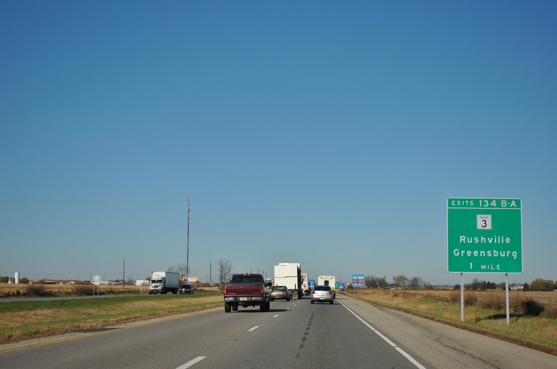
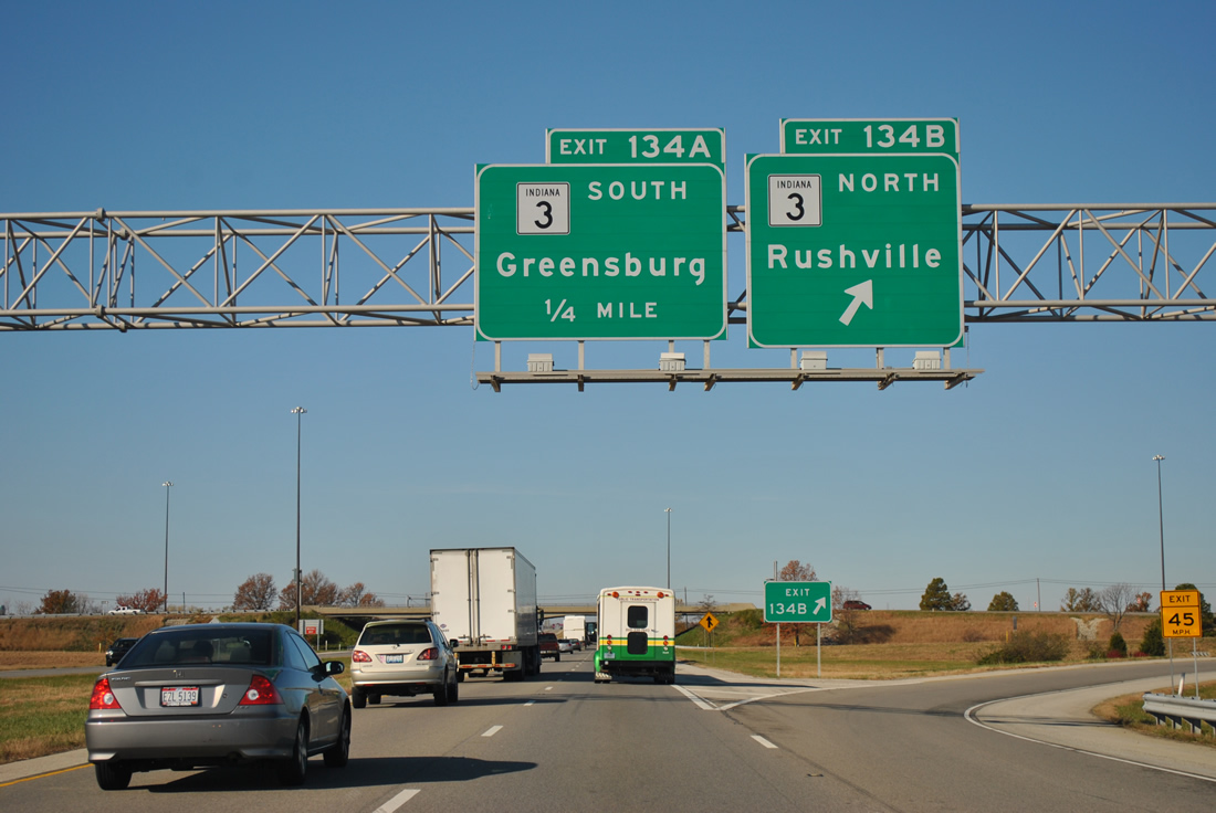
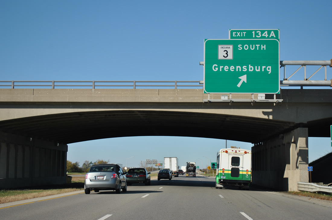
| SR 3 consists of an expressway bypass along the west side of Greensburg that begins at the Exit 134 cloverleaf interchange with Interstate 74. 11/04/11 |
|
| One mile east of SR 3 along Interstate 74 west. SR 3 comprises a 7.1 mile expressway from Exit 134A to the split with SR 46 west near Ewington. SR 3 travels as a rural two lane road south from there to Westport and North Vernon. 11/04/11 |
|
| Another two-segment route, SR 3 exists for 178.8 miles from Charlestown to Fort Wayne and again for 44.8 miles from Fort Wayne to Brighton. 11/04/11 |
|
| Drivers bound for Sandusky or Rushville leave Interstate 74 west at Exit 134B for SR 3 north. The Rush county seat is a 17 mile drive to the north. 11/04/11 |
|
| Exit 134A joins SR 3 south into a commercial area to Lincoln Street (old SR 3). SR 3/46 combine along West Main Street on the outskirts of town. Interests to Columbus are directed onto SR 46 west for Hartsville and the Bartholomew County seat. 11/04/11 |
|
| Meeting Interstate 74 west next is U.S. 421 north from Michigan Avenue and Greensburg in one mile at Exit 132. 11/04/11 |
|
| Interstate 74 westbound shield posted by farm fields ahead of the County Road 100 over crossing. 11/04/11 |
|
| U.S. 421 enters Interstate 74 west from a southerly course between Greensburg, Versailles and Madison. The US highway totals 232 miles in Indiana overall between the Ohio River and a northern terminus at Michigan City. 11/04/11 |
|
| Originally a wye interchange brought U.S. 421 northbound traffic onto Interstate 74 west at Exit 132. Construction reconfigured Exit 132 into a six-ramp parclo interchange on July 9, 2008 with new Overpass Road looping north and west from U.S. 421 to serve a Honda auto assembly plant built to the west. 11/04/11 |
|
| I-74/U.S. 421 combine for the remaining miles between Greensburg and the Indianapolis beltway. Saint Paul is the next destination of interest in ten miles. Shelbyville, the Shelby County seat, is 16 miles away. 11/04/11 |
|
| Shields assembly for the north west tandem posted at Overpass Road. Although this is the first meeting of Interstate 74 and U.S. 421 in Indiana, the two will also meet in Winston-Salem, North Carolina when I-74 is fully signed there. 11/04/11 |
|
| A 1961 concrete overpass carries County Road 420 West north to Downeyville and south to Adams. Old U.S. 421 diverges from the freeway corridor to the west along this stretch. 11/04/11 |
|
| Michigan Avenue (Old U.S. 421) travels through St. Omer to interact with I-74/U.S. 421 again at the Exit 123 folded-cloverleaf interchange with Mohrwood Road. Ramps along the eastbound roadway directly connect with the former US Highway. 11/04/11 |
|
| County Road 800 leads south from Exit 123 along the Decatur / Shelby County line to the town of Saint Paul. Northward County Road 800 Road (Mohrwood Road) continues to SR 244 and Blue Ridge. 11/04/11 |
|
| Exit 123 loops onto County Road 800 Road (Mohrwood Road) from Interstate 74 west / U.S. 421 north. 11/04/11 |
|
| The corner of Decatur, Rush and Shelby Counties lies directly at the Mohrwood Road overpass. I-74/U.S. 421 officially enter Shelby County only. 11/04/11 |
|
| Travelers destined for Middletown or Waldron should follow Michigan Avenue west as old U.S. 421 parallels the freeway. 11/04/11 |
Page Updated 01-17-2012.


 West
West


 North
North