|
| Leading west from the Garden State Parkway, Interstate 78 travels through Union Township to a pair of ramps (Exits 50B/A) with Vauxhall Road (CR 630). 08/04/07 |
|
| Exit 50B connects I-78 west with Vauxhall Road (CR 630) north to Vauxhall and CR 577 (Millburn Avenue) west to Millburn. Intersections with Route 124 (Springfield Avenue and CR 638 (Valley Street) lead motorists northeast into Maplewood Township. 08/04/07 |
|
| Exit 50A loops onto Vauxhall Road (CR 630) southeast through Union Township. 08/04/07 |
|
| The Local lanes of Interstate 78 west diverge from the Express lanes to accommodate separate on-ramps from Route 124 (Springfield Avenue). I-78 next splits with the Route 124 freeway at a tri-level stack interchange. 08/04/07 |
|
| New Jersey 24 branches northwest from I-78 along a 10.31 mile freeway to Interstate 287 at Hanover Township. 08/04/07 |
|
| A sharp ramp awaits motorists bound for New Jersey 24 (Exit 48) west. 08/04/07 |
|
| Passing under County Route 577 (Main Street), the Local lanes of I-78 west approach their westbound merge with the Express lanes in 0.75 miles. 08/04/07 |
|
| New Jersey 24 winds northwest along the Summit city line to Chatham, Florham Park, Madison and an end with I-287 outside Morristown. 08/04/07 |
|
| Exit 48 leaves the Local lanes of I-78 west as they combine with the Express lanes. The Route 24 freeway was only completed in 1992. 08/04/07 |
|
| Interstate 78 veers southward onto First Watchung Mountain just west of New Jersey 24. 08/04/07 |
|
| I-78 winds through Watchung Reservation to the Summit city line at Glenside Avenue (CR 527). Construction of this stretch of freeway was delayed due to potential environmental impacts. Part of the compromise for completing the freeway were environmental considerations, including overpasses designed to accommodate wildlife. 08/04/07 |
|
| A half diamond interchange adds traffic from Glenside Avenue (CR 527). 08/04/07 |
|
| A pair of wildlife over crossings follow along I-78 west, north of Lake Surprise. 08/04/07 |
|
| County Route 527 (Glenside Avenue) parallels the south side of I-78 to Berkeley Heights Township and CR 655 (Diamond Hill Road). Forthcoming Exit 43 departs for Diamond Hill Road in one mile. 08/04/07 |
|
| Diamond Hill Road leads north to the borough of New Providence and south to Watchung and Scotch Plains Township. 08/04/07 |
|
| Exit 43 parts ways with Interstate 78 west for Diamond Hill Road (CR 630) in Berkley Heights Township. CR 527 intersects CR 630 just to the south, following Valley Road west into the borough of Watchung. 08/04/07 |
|
| Straddling the hillside of Second Watchung Mountain, I-78 west next meets Drift Road in Watchung. 08/04/07 |
|
| Drift Road winds north from Exit 41 to Plainfield Avenue. Plainfield Avenue (CR 633) north connects I-78 with the Berkeley Heights Township center. 08/04/07 |
|
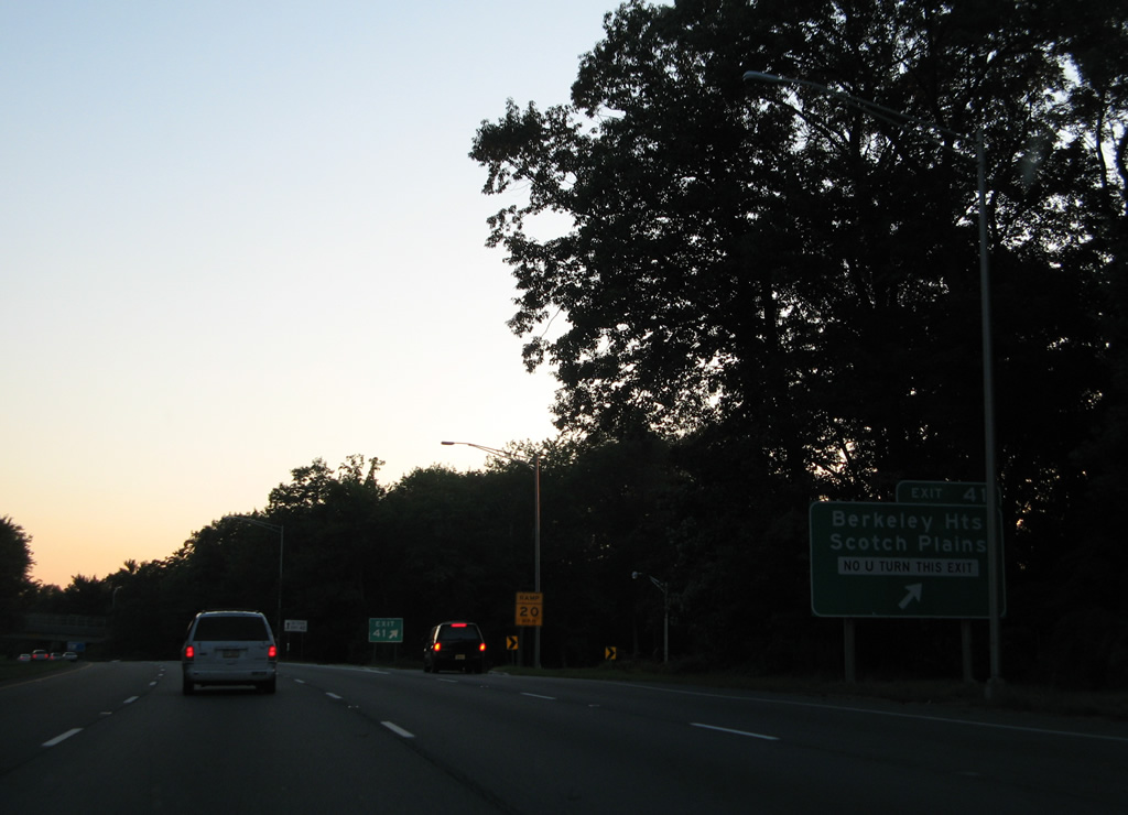
| South from Exit 41, Drift Road transitions into Dale Road onto Second Watchung Mountain. Plainfield Avenue / Bonnie Burn Road east leads drivers to the Scotch Plains Township street grid. 08/04/07 |
|
| Continuing west through the forested hillside of Second Watchung Mountain, I-78 west exits Watchung for Warren Township. 08/04/07 |
|
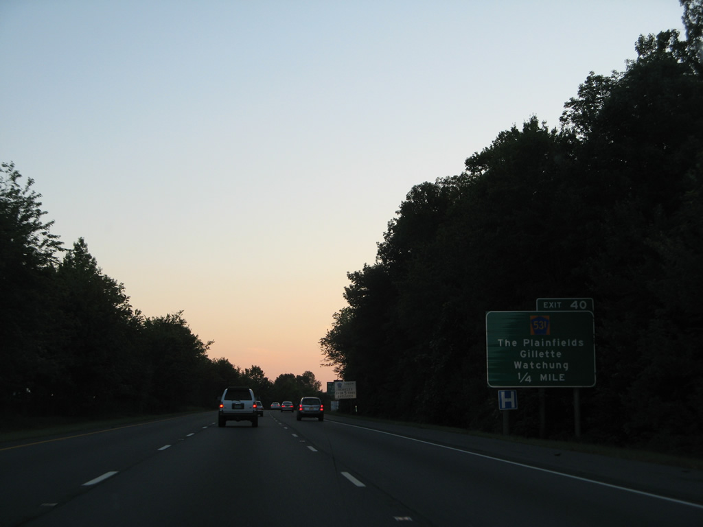
| Meeting I-78 in one half mile is County Route 531 (Hillcrest Road) at a six-ramp parclo interchange (Exit 40). 08/04/07 |
|
| CR 531 (Hillcrest Road) heads north 1.7 miles to end at County Route 512 at the community of Gillette. 08/04/07 |
|
| Exit 40 departs Interstate 78 west for CR 531 (Hillcrest Road). CR 531 extends south across Watchung to North Plainfield, Plainfield and South Plainfield Township. 08/04/07 |
|
| Reassurance marker for I-78 west posted ahead of milepost 40 in Warren Township. 08/04/07 |
|
| Clinton lies midway between I-78 and the Pennsylvania state line in 22 miles. Phillipsburg, 39 miles away, lies along the Delaware River. 08/04/07 |
|
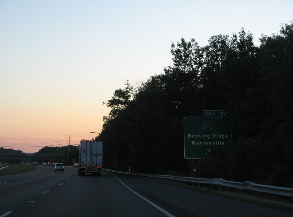
| Interstate 78 and the Passaic River come together at the forthcoming six-ramp parclo interchange (Exit 36) with County Route 651 (King George Road). 08/04/07 |
|
| CR 651 winds northwest from Middlesex to Warrenville and Mount Bethel before reaching I-78 along King George Road. 08/04/07 |
|
| North of Exit 36, CR 651 crosses the Dead River into Bernards Township en route to CR 512 (Valley Road) near Stone House. CR 613 continues the drive north from CR 512 to Basking Ridge by way of Lyons. 08/04/07 |
|
| Interstate 78 traverses a forested area south of the Dead River over the next several miles. 08/04/07 |
|
| Another six-ramp parclo interchange (Exit 33) joins I-78 with County Route 525 (Martinsville Road) in 0.75 miles. 08/04/07 |
|
| County Route 525 (Martinsville Road) climbs southward to Mount Horeb before dropping from Second Watchung Mountain into Martinsville. 08/04/07 |
|
| Bernardsville lies ten miles to the north of Exit 33 via Somerset County 525 north. 08/04/07 |
|
| Interstate 78 rises nearly 300 feet in elevation over the next two miles. 08/04/07 |
|
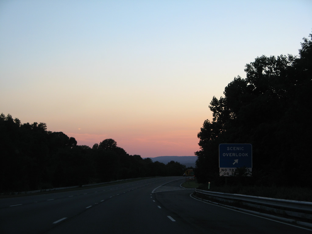
| The freeway crests at a scenic overlook onto Second Watchung Mountain by the Bridgewater Township Line. 08/04/07 |
|
| Straddling the north end of First Watchung Mountain, Interstate 78 lowers over 300 feet to meet Interstate 287 at a directional cloverleaf interchange (Exit 29) in Bedminster Township. 08/04/07 |
|
| U.S. 202 & 206 pass under Interstate 78 at the Exit 29 ramp departure for Interstate 287. I-287 parallels U.S. 202 & 206 north to the next exit near Pluckemin and south to Somerville. 08/04/07 |
|
| Truckers taking Exit 29 onto I-287 south are advised of a sharp curve for left side merging ramp.
Cushetunk Mountain appears along the western horizon. 08/04/07 |
|
| Interstate 287 encircles the North Jersey metropolitan area from Suffern, New York southward to Riverdale, Morristown and Somerville and eastward to Piscataway, Metuchen and Edison Township. 08/04/07 |
|
| Exit 29 carries all traffic in unison to Interstate 287 from I-78 west. I-287 travels 67.52 miles in New Jersey and nearly 99 miles overall to Rye, New York. U.S. 202 parallels I-287 north from Somerville to New York while U.S. 206 branches northwest to Chester and south to Princeton. 08/04/07 |
|
| Interstate 78 becomes vastly more rural west of I-287 through Bedminster Township. 08/04/07 |
|
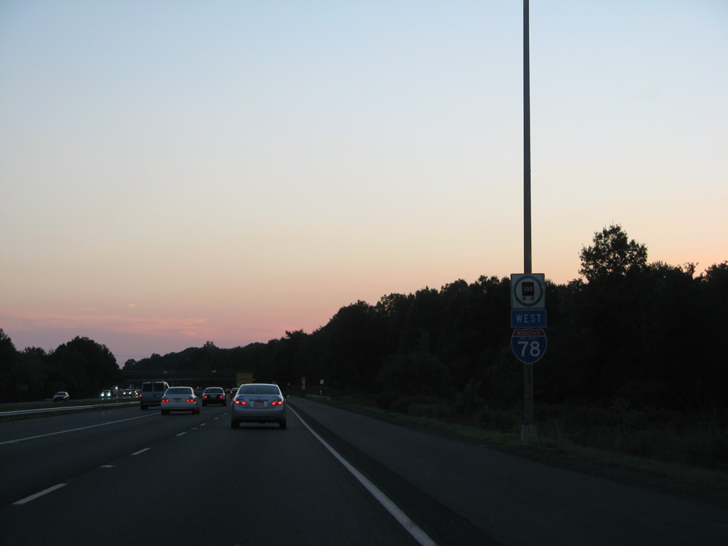
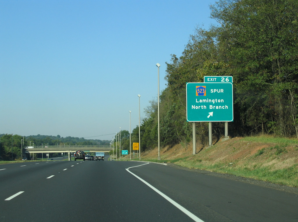
| The final Somerset County exit joins I-78 west with County Route 665 (Rattlesnake Bridge Road) in one mile. Signs for Exit 26 reference County Route 523 Spur, the former designation of CR 665. 10/01/05 |
|
| CR 665 (Rattlesnake Bridge Road) consists of a rural route north from Exit 26 to CR 523 at Lamington. 10/01/05 |
|
| Exit 26 leaves Interstate 78 west for CR 665. CR 665 south ends a 4.15 mile route at CR 614 in Branchburg Township, just west of North Branch. 10/01/05 |
|
| Interstate 78 crosses the Lamington River into both Readington Township and Hunterdon County. 08/04/07 |
|
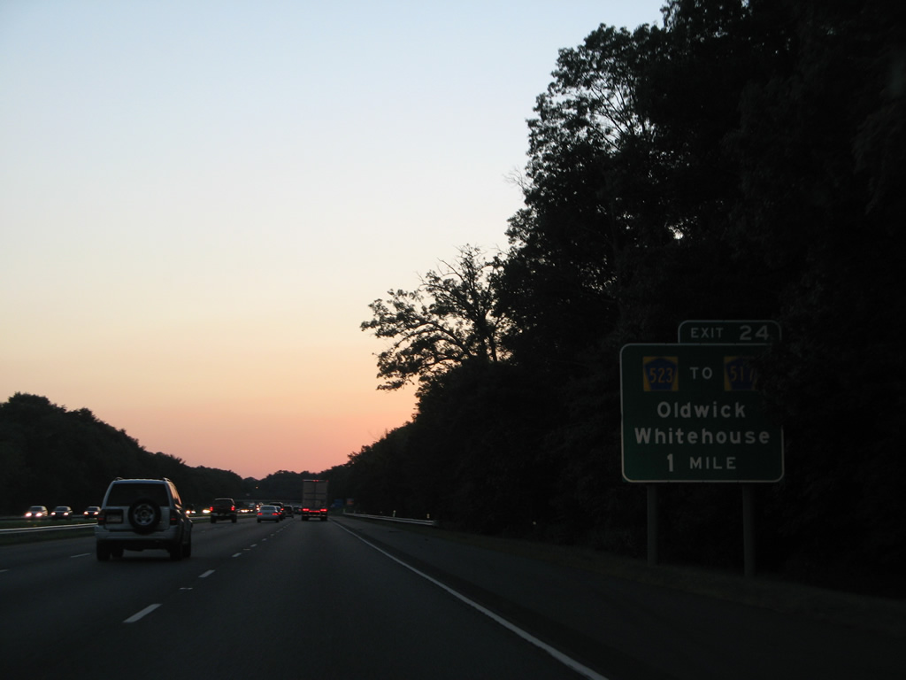
| One mile east of the diamond interchange (Exit 24) with County Route 523 (Oldwick Road) on Interstate 78 west. 08/04/07 |
|
| Westbound travelers enter southern Tewksbury Township ahead of Exit 24 to County Route 523 (Oldwick Road). CR 523 takes Oldwick Road north to Lamington Road east. There CR 517 begins and heads north to Oldwick. 10/01/05 |
|
| Westbound I-78 at the Exit 24 off-ramp to CR 523 (Oldwick Road). CR 523 extends another two miles south by the Merck corporate headquarters campus to U.S. 22 at Whitehouse. 10/01/05 |
|
| The town of Clinton is another eight miles to the west, followed by Phillipsburg in 25 miles. 10/01/05 |
|
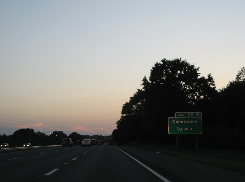
| Interstate 78 winds west into Clinton Township, next meeting County Route 639 (Exit 20) in the borough of Lebanon. 10/01/05 |
|
| A partial interchange provides two ramps for CR 639 (Cokesbury Road) from I-78 west. Exit 20B serves CR 639 north to Cokesbury. 08/04/07 |
|
| Exit 20B departs I-78 west for CR 639 (Cokesbury Road) north. CR 639 runs 5.73 miles north to Cokesbury and west to High Bridge from U.S. 22 in Lebanon. 08/04/07 |
|
| U.S. 22 parallels I-78 just to the south through Lebanon. CR 639 connects the two routes east of CR 751 south to Round Valley Recreation Area. Round Valley Reservoir, contained by Cushetunk Mountain, lies to the south of Lebanon. The 2,000 acre lake is 180 feet deep, representing the deepest in the state.1 10/01/05 |
|
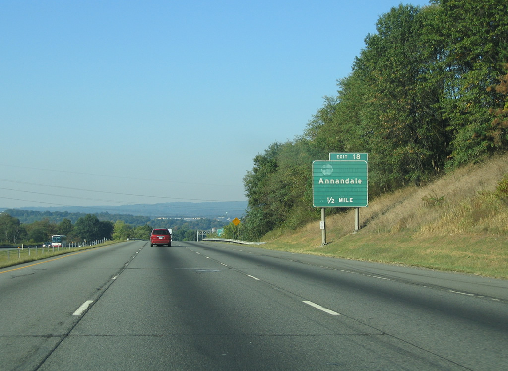
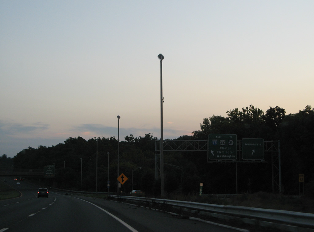
| U.S. 22 and Interstate 78 proceed west from Lebanon to come together at a wye interchange (Exit 18) at Annandale. The exit was originally signed as the southbound connection to Route 31. 10/01/05 |
|
| Interstate 78 drops from around 450 above sea level to around 200 feet in the Town of Clinton over the next two miles. 10/01/05 |
|
| Sign changes made between 2005 and 2007 re-referenced Exit 18 from Route 31 south to Flemington to Annandale. The forthcoming ramp joins Beaver Avenue (CR 626), the former alignment of U.S. 22, west through Annandale to Route 173 and Route 31 outside Clinton. 10/01/05, 08/04/07 |
|
| Exit 18 departs Interstate 78 west for CR 626 through Annandale, 0.75 miles ahead of a directional interchange (Exit 17) with Route 31. 10/01/05 |
|
| Traffic taking Exit 18 joins U.S. 22 west briefly before it merges onto Interstate 78 through Clinton. 08/04/07 |
|
| A lane gained from U.S. 22 west defaults onto Exit 17 for Route 31 north to High Bridge, Glen Gardner and Hampton. The original pull-through panel for I-78 west was removed by 2007. 10/01/05 |
|
| Interstate 78 & U.S. 22 share 14.3 miles of pavement west to Greenwich Township. 08/04/07 |
|
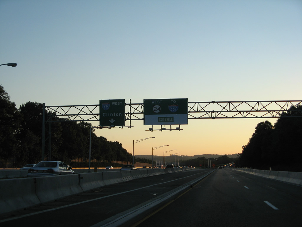
| Route 31 totals 48.93 miles from Trenton north to U.S. 46 at Buttzville. The state route combines with U.S. 202 at Flemington to the south while traveling ten miles to the borough of Washington to the north. 10/01/05 |
|
| Exit 17 joins Route 31 north ahead of its interchange with Route 173 and CR 626 (Beaver Street). Motorists bound for Route 31 south are directed to U-turn at Route 173 for Flemington. 10/01/05 |
|
| Route 173 begins from Route 31 and CR 626 and winds west along former U.S. 22 through Clinton. A wye interchange connects the state route with I-78 & U.S. 22 west ahead of the town line. 08/04/07 |
|
| Route 173 (Main Street) ties into Interstate 78 & U.S. 22 at a parclo interchange (Exit 15) with County Route 513 (Pittstown Road) just west of the Raritan River South Branch. 10/01/05 |
|
| Hunterdon County 513 overlaps with Route 173 (Main Street) through Clinton. The county route emerges at Exit 15, heading south along the Franklin / Union Township line to Pittstown. 08/04/07 |
|
| Route 173 briefly joins Interstate 78 & U.S. 22 west as the freeway overtakes the original U.S. 22 alignment. 08/04/07 |
|
| Easton, Pennsylvania debuts on westbound distance signs at 16 miles out. 08/04/07 |
|
| Route 173 splits with I-78 & U.S. 22 west at a half diamond interchange (Exit 13) to follow the north side service road to Perryville. 08/04/07 |
|
| A modified diamond interchange (Exit 12) again ties in Route 173 with Interstate 78 & U.S. 22 at Perryville. 08/04/07 |
|
| County Route 625 south and 635 north meet at Route 173 in Perryville. CR 635 arcs northeast 6.31 miles to Norton, Charlestown and the borough of Hampton. 10/01/05 |
|
| Exit 13 departs for adjacent Route 173 west ahead of CR 625 south to CR 579 at Mechlin Corner. Perryville Road branches southeast from CR 625 nearby to the settlement of Jutland. 10/01/05 |
|
| Interstate 78 & U.S. 22 turn more northerly toward Musconetcong Mountain. 08/04/07 |
|
| Route 173 remains alongside I-78 & U.S. 22 west to a modified diamond interchange (Exit 11) at CR 614 (Pattenburg Road) 10/01/05 |
|
| Westbound traffic spans Mulhockaway Creek on the half mile approach to Exit 11 with Route 173. CR 614 stems southwest 7.70 miles from a traffic circle with Route 173 to Pattenburg, Little York and CR 519 at Spring Mills. 10/01/05 |
|
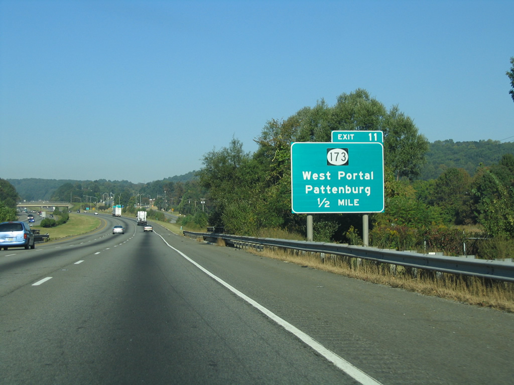
| Route 173 branches away from the freeway between Exit 11 and West Portal across Musconetcong Mountain. 10/01/05 |
|
| Interstate 78 & U.S. 22 wind west across Musconetcong Mountain, reaching a summit of over 800 feet above sea level. A set of rest areas line both sides of the freeway on the north slope of the mountain. 08/04/07 |
|
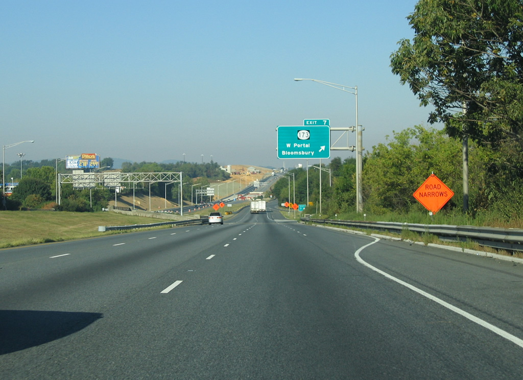
| Route 173 returns alongside I-78 & U.S. 22 from West Portal to meet the freeway at Exit 7 just beyond the rest area. 10/01/05 |
|
| Interstate 78 & U.S. 22 lower into the borough of Bloomsbury and Musconetcong Valley at Exit 7 with Route 173 (Clinton street). 10/01/05, 08/04/07 |
|
| Route 173 acts as a business loop for I-78 through Bloomsbury, returning to the freeway at Exit 3.
Constructed in 2004/05 west of the Musconetcong River, a new set of truck weigh stations resulted in sign changes at Exit 7. 10/01/05, 08/04/07 |
|
| Interstate 78 & U.S. 22 cross the Musconetcong River and Warren County line ahead of a half diamond interchange with Bloomsbury Road (CR 632). 10/01/05 |
|
| Westbound travelers nip the southern corner of Franklin Township ahead of the weigh station and Greenwich Township line. 08/04/07 |
|
| Warren County 637 meanders northward from CR 639 (Warren Glen Road) to meet I-78 & U.S. 22 at a half diamond interchange (Exit 4) in one mile. 08/04/07 |
|
| CR 637 continues north from Exit 4 to Stewartsville, Route 57 and CR 519 in Lopatcong Township. 08/04/07 |
|
| U.S. 22 leaves Interstate 78 in two miles for Phillipsburg. The two routes will reconvene west of Allentown, Pennsylvania. 10/01/05 |
|
| New Village Road spans I-78 & U.S. 22 west at the Exit 4 off-ramp to CR 637 (Main Street). Warren Glen lies southwest of Silver Hill via CR 639 west. 10/01/05 |
|
| One mile east of the directional cloverleaf interchange (Exit 3) with U.S. 22 west to Phillipsburg and Route 122 west to the borough of Alpha. Route 173 ties into Exit 3 from the south. 10/01/05 |
|
| U.S. 22 angles northwest from Exit 3 along a busy commercial arterial to Phillipsburg Mall and Memorial Parkway outside the Phillipsburg town limits. Route 122 spurs west 2.42 miles west from nearby to Alpha and South Main Street into Phillipsburg. The state route was formerly signed as U.S. 22 Alternate. 10/01/05 |
|
| Interstate 78 and U.S. 22 partition at Still Valley and Exit 3. U.S. 22 travels another 5.07 miles to the state line into Easton, Pennsylvania. There the route upgrades to the Lehigh Valley Thruway, the former route of I-78, to Bethlehem and Allentown. 10/01/05 |
|
| Interstate 78 encircles Alpha on the final three miles to the Delaware River. This portion of freeway opened to traffic on November 21, 1989.2 08/04/07 |
|
| Curving northward through Pohatcong Township, Interstate 78 reaches its final mile in the Garden State. 08/04/07 |
|
| The bridge across the Delaware River is tolled in the westbound direction. The toll collection point resides two miles ahead at South Easton. 08/04/07 |
|
| Interstate 78 spans the Delaware River along twin 1,222 foot long four-girder bridges.2 10/01/05 |
|
| Midway across the Delaware River, I-78 travelers enter both Williams Township and Northampton County, Pennsylvania. 10/01/05 |
Page Updated 05-07-2014.

 West
West


 West
West