|
| U.S. 29 enters the city of Valley south from the diamond interchange (Exit 79) with I-85 along 20th Avenue to the communities of Shawmut and Langdale. Turning westward from Valley, U.S. 29 meets the freeway again in Lee County. 12/31/12 |
|
| U.S. 29 (Broad Avenue) heads 0.64 miles northwest to SR 50 (Veterans Memorial Parkway) in Lanett. U.S. 29 shifts northeast onto Gilmer Avenue from SR 50 to 3rd Avenue through the West Point, Georgia city center. 12/31/12 |
|
| Having just crossed the Chattahoochee River, the Alabama welcome sign on I-85 south precedes Exit 79. North from Lanett and West Point, the state line diverges from the waterway along the 35th parallel as the Chattahoochee turns northeast. This boundary dates back to the partition of the Georgia and Mississippi Territory.1 12/31/12 |
|
| U.S. 29 crosses Interstate 85, 0.74 miles from the Alabama welcome center and rest area. 12/31/12 |
|
| The Alabama welcome center lies just beyond Moores Creek. The final rest area along Interstate 85 south follows in 35 miles. 12/31/12 |
|
| The first confirming marker posted for Interstate 85 along the 80.01 mile long course through the Heart of Dixie. 12/31/12 |
|
| Interstate 85 stays just west of Valley to the diamond interchange (Exit 77) with Chambers County Route 208. Distances signs along I-85 south referencing Downtown Montgomery are two miles too high. 12/31/12 |
|
| County Road 208 arcs west from Langdale in Valley along Fob James Drive to Exit 77 and along Phillips Road to Huguley. 12/31/12 |
|
| CR 208 north continues from SR 50 at Huguley to CR 84 in western reaches of Lanett. The Southern Union State Community College - Valley Campus is along Fob James Drive to the east. 12/31/12 |
|
| Interstate 85 enters a long forested stretch from outside Valley southwest toward the Lee County line. 12/31/12 |
|
| Distance sign posted 23 miles ahead of Auburn and 76 miles from Downtown Montgomery. This assembly was knocked over in 2012 but later repaired. 07/11/10 |
|
| Although all of Chambers County officially falls within Central Time Zone, the time zone sign along Interstate 85 southbound does not appear until after Exit 77. Lanett and Valley observe Eastern Time due to their proximity to West Point, Georgia. 12/31/12 |
|
| Chambers County 388 crosses paths with I-85 at a diamond interchange (Exit 70) in one mile. 12/31/12 |
|
| CR 388 connects Interstate 85 with U.S. 29 on the outskirts of Valley to the east. Westward, CR 88 defaults onto CR 83 north to the town of Cusseta and the county seat of Lafayette. 12/31/12 |
|
| Opelika, the Lee County seat, lies nine miles to the southwest. Montgomery is now an hour away. 12/31/12 |
|
| Interstate 85 nips corners of Lee and Chambers Counties before reentering Lee County at the Chambers County Route 177 overpass. 12/31/12 |
|
| Andrews Road arcs west from U.S. 29 to Lee County Route 162 and the community of Andrews in northeast Opelika. The arterial was constructed to serve an industrial park along the west side of Interstate 85 at Exit 66. 07/11/10 |
|
| Exit 66 is the first of five interchanges to serve the city of Opelika. Home to 30,995 per the 2020 census, Opelika was named from the Muskogee word meaning large swamp. The city was incorporated as a town on February 9, 1854.2 12/31/12 |
|
| The parclo interchange (Exit 66) at Andrews Road was constructed between 2001 and 2003. Entering Lee County ahead of Pine Grove, U.S. 29 continues from the east end of Andrews Road to I-85 at Exit 64. 12/31/12 |
|
| Interstate 85 advances south past Northeast Opelika Industrial Park. 12/31/12 |
|
| Downtown Opelika is 5.4 miles southwest from mile marker 66. The Alabama capital city is 66 miles away. 12/31/12 |
|
| U.S. 29 and Interstate 85 come together again at a diamond interchange (Exit 64) with West Point Parkway. 12/31/12 |
|
| U.S. 29 previously continued along West Point Parkway to Samford Avenue at U.S. 431. The former route then used 2nd Avenue and Pepperell Parkway west through the Opelika street grid. This alignment was relinquished from state maintenance and the relocation of U.S. 29 onto I-85 formally approved by AASHTO on April 7, 2000. 12/31/12 |
|
| U.S. 29 south combines with Interstate 85 for 13.11 miles through Opelika and Auburn. 12/31/12 |
|
| Continuing by West Ridge Park in Opelika, the city center is three miles to the west via I-85/U.S. 29 and the succeeding exit. 12/31/12 |
|
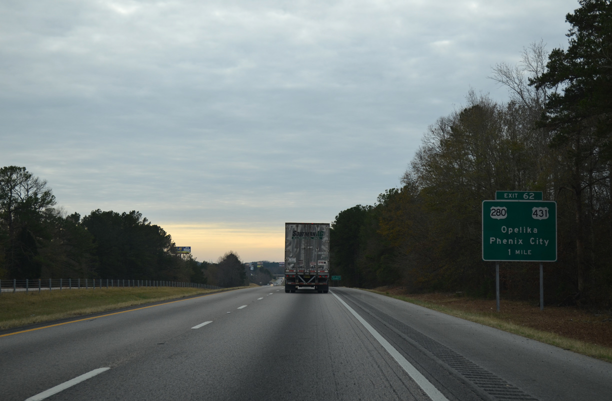
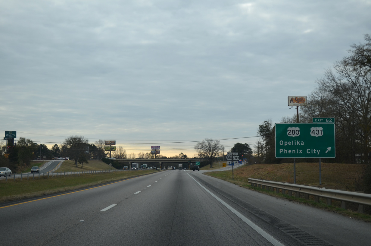
| U.S. 280/431 overlap 22.36 miles northwest from U.S. 80 (J.R. Allen Parkway) in Phenix City to a diamond interchange (Exit 62) with I-85/U.S. 29. The two separate at Exit 62, with U.S. 280 west joining I-85/U.S. 29 south to Exit 58 and U.S. 431 taking Fox Run Parkway north to bypass central Opelika. 12/31/12 |
|
| U.S. 280/431 (Columbus Parkway) join Auburn and Opelika with Smiths Station, Phenix City, and Columbus, Georgia to the southeast. North from Opelika, U.S. 431 continues to Lafayette and Anniston 12/31/12 |
|
| U.S. 280 joins I-85/U.S. 29 south for 3.44 miles. The original alignment followed Columbus Parkway west, 7th Street north to Downtown Opelika and 2nd Avenue (old U.S. 29) west. The alignment later shifted onto 10th Street and U.S. 29. 12/31/12 |
|
| Approved by AASHTO on April 8, 2000, the realignment of U.S. 280 out of Downtown Opelika coincided with the relocation of U.S. 29. 12/31/12 |
|
| Beginning at forthcoming Exit 60, SR 51 runs 13.82 miles south to U.S. 80 at Marvyn. SR 169 branches southeast from SR 51, 0.58 miles south of I-85/U.S. 29-280 along a 26.32 mile long route to Crawford and U.S. 431 outside Seale. 12/31/12 |
|
| The folded diamond interchange (Exit 60) with SR 51 (Marvyn Parkway) south and Geneva Street north lies opposite a Norfolk Southern Railroad line. Geneva Street ties into the exchange from 10th Street (former U.S. 280) and Downtown Opelika. SR 51 comprises a 114.18 mile highway south to Hurtsboro, Clayton, Clio and New Brockton. 12/31/12 |
|
| I-85/U.S. 29 south and U.S. 280 west run north of an industrial area beyond the NS Railroad under crossing. 12/31/12 |
|
| The city of Auburn appears as the next destination six miles out. Sign changes made between 2005 and 2010 adjusted the mileage for Montgomery from 62 to 60 miles. 12/31/12 |
|
| U.S. 280 part ways with I-85/U.S. 29 south at parclo interchange (Exit 58) with Gateway Drive. 12/31/12 |
|
| Gateway Drive was constructed in 1999 from the intersection of Pepperell Parkway (old U.S. 29) and Birmingham Highway south to a new interchange with I-85. The roadway was then extended eastward to CR 54 (Capps Way) and SR 51 (Marvyn Parkway). 12/31/12 |
|
| U.S. 280 joins the Auburn and Opelika area with Dadeville, Alexander City, Sylacauga, Childersburg and Birmingham to the northwest. Retail enveloped most areas north of Exit 58 to Frederick Road since the exchange opened. 12/31/12 |
|
| Hamilton Road spans I-85 south from Tiger Town Shopping Center beyond this reassurance marker. 12/31/12 |
|
| Originally signed for Glenn Avenue, forthcoming Exit 57 connects I-85/U.S. 29 with Bent Creek Road midway between parallel Glenn Avenue and Hamilton Road. 12/31/12 |
|
| The diamond interchange at Exit 57 serves adjacent Auburn University Regional Airport (AUO), which was named Auburn-Opelika Robert G. Pitts Airport until November 2009.3 07/11/10 |
|
| Exit 57 leaves I-85/U.S. 29 south for Bent Creek Road to Glenn Avenue and AUO Airport. Glenn Avenue continues west to Downtown Auburn and east to become Frederick Road in Opelika. 12/31/12 |
|
| Replaced by 2016, this older style shield for Interstate 85 appeared as the freeway passed by the south runway approach to AUO Airport. 07/11/10 |
|
| The stretch between Exits 57 and 51 is 5.57 miles in length. Auburn, referenced at four miles out, refers to the upcoming diamond interchange with S College Street. 07/11/10 |
|
| U.S. 29 parts ways with I-85 south at Exit 51 and leads away from Auburn to Tuskegee and Union Springs. SR 147 follows S College Street (old U.S. 29) north 1.39 miles to Shug Jordan Parkway, an arterial bypass west of Downtown Auburn. 12/31/12 |
|
| Exit 51 departs Interstate 85 south for U.S. 29 south, Chewacla State Park, College Street (old U.S. 29) north to the campus of Auburn University, and SR 147 to U.S. 431 at The Bottle. 12/31/12 |
|
| Interstate 85 expands with auxiliary lanes between Exit 51 / S College Street and the diamond interchange at Exit 50. 12/31/12 |
|
| Interstate 85 runs between sections of Auburn Technology Park. Established in 2008, increased traffic projects for the 340 acre park were the impetus for a $18 million project to construct a new interchange (Exit 50) at Cox Road.5 12/31/12 |
|
| Originally scheduled to open in July 2012, utility conflicts delayed the completion6 of Exit 50 until November 29, 2012. Exit 50 may eventually connect I-85 with the proposed Auburn Outer Loop. The at-grade bypass would likely become part of a realigned SR 147.7 12/31/12 |
|
| Auburn Technology Parkway replaced a portion of Cox Road (County Road 12), when it was constructed across Interstate 85. Cox Road leads north from the parkway to Wire Road and east to U.S. 29 (S College Street). 12/31/12 |
|
| Interstate 85 advances southwest through a wooded area ahead of Choctataula Creek. 12/31/12 |
|
| Southbound distance sign posted seven miles out from Wire Road (CR 53), the first exit beyond the Auburn area. 12/31/12 |
|
| Interstate 85 enters Macon County, 47.47 miles from I-65/U.S. 82 in Montgomery. 12/31/12 |
|
| The final rest area along Interstate 85 lies west of Hodnett Creek within Tuskegee National Forest. 07/11/10 |
|
| The Macon County Rest Areas along both roadways were not built during the original construction of Interstate 85. 07/11/10 |
|
| Exit 42 joins Interstate 85 south with the west end of SR 186 in one mile. The 3.83 mile long route connects the freeway with U.S. 29 and U.S. 80. 12/31/12 |
|
| Wire Road (Lee County Route 137 / Macon County Route 53) meanders west from Auburn and ties into Exit 42 from the north. CR 53 continues southwest of SR 186 to U.S. 80 in Tuskegee National Forest. 12/31/12 |
|
| Exit 41 departs I-85 south after Miles Creek. SR 186 is part of a route joining Montgomery and Phenix City along with U.S. 80 east beyond the separation with U.S. 29. U.S. 29/80 combine 7.45 miles west to the Tuskegee city center. 12/31/12 |
|
| Interstate 85 crosses Choctahatchee Creek south beyond this confirming marker. 07/11/10 |
|
| Progressing westward toward Montgomery, Interstate 85 next passes just north of the Tuskegee city limits city of Tuskegee at Exit 38. 12/31/12 |
Page Updated 08-02-2022.

 South
South


 south
south


 West
West