|
| Interstate 93 crosses over U.S. 3 beyond this reassurance marker posted in Plymouth. 10/06/14 |
|
| North from Plymouth, Interstate 93 heads eight miles into the town of Campton. Littleton is now 40 miles to the north of the White Mountains.
A sign change made by 2014 revised the mileage to Campton from seven to eight. 10/06/14 |
|
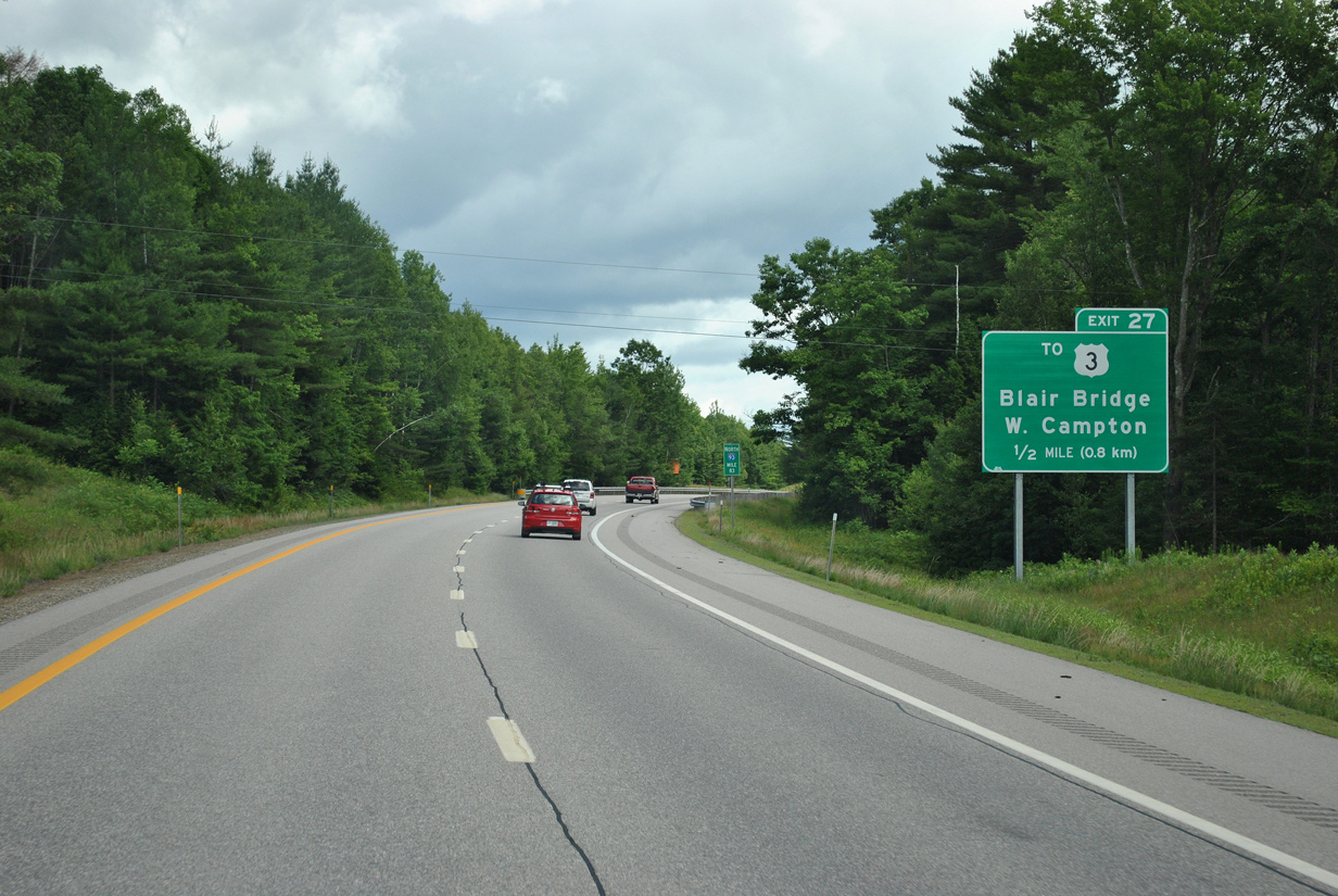
| Winding north toward Round Hill, Interstate 93 next meets Blair Road at Exit 27 in one mile. 07/29/07 |
|
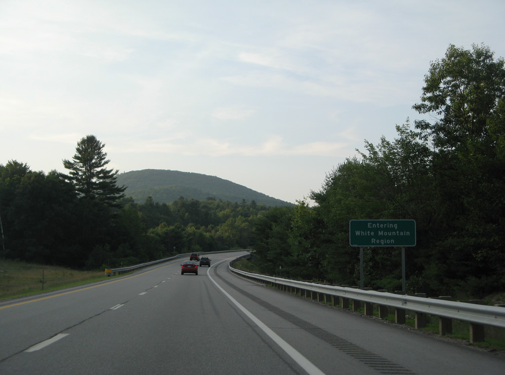
| The next 35 miles of Interstate 93 traverse the scenic White Mountain Region of northern New Hampshire. 07/29/07 |
|
| Blair Road stems east from adjacent Bog Road to connect I-93 with parallel U.S. 3 (Daniel Webster Highway) and the Blair Bridge across the Pemigewasset River. 06/27/12 |
|
| Northbound at the diamond interchange (Exit 27) with Blair Road on I-93 north. Blair Road ends to the east at NH 175 (Livermore Road). U.S. 3 leads north to West Campton. 06/27/12 |
|
| Interstate 93 crosses over both U.S. 3 and the Pemigewasset River again beyond Blair Road. 07/29/07 |
|
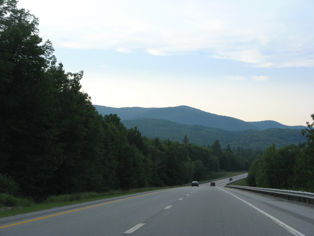
| Mount Tecumseh (elevation 4,003 feet) and Mount Osceola (elevation 4,340 feet) appear among other peaks of the White Mountains as Interstate 93 travels seven miles north to Thornton and 15 miles to Lincoln. 07/29/07 |
|
| A diamond interchange (Exit 28) joins Interstate 93 with NH 49 (Waterville Road) at Campton Station in one mile. 06/27/12 |
|
| Forthcoming NH 49 ends at U.S. 3 just west of Exit 28. The 12.7 mile route roams northeast beside the Mad River to East Thornton and an end at Waterville Valley. 06/27/12 |
|
| Exit 28 leaves Interstate 93 north for NH 49 west to West Campton and north to Campton Upper Village and NH 175 (Livermore Road). 06/27/12 |
|
| Interstate 93 curves westward again by Sunset Hill toward the Thornton town line. 07/29/07 |
|
| U.S. 3 heads north from West Campton to cross paths with I-93 once more at a folded diamond interchange (Exit 29) in one mile. 06/27/12 |
|
| Blake Mountain (elevation 1,532 feet) rises prominently as Interstate 93 nears the off-ramp (Exit 29) for U.S. 3. 06/27/12 |
|
| U.S. 3 shifts to the east of I-93 from Exit 29 northward through Thornton and West Thornton. 06/27/12 |
|
| Interstate 93 stays above U.S. 3 along the east slope of Blake Mountain and Mount Kineo to West Thornton. 07/29/07 |
|
| Woodstock lies six miles ahead between Exits 30 and 31. Lincoln follows ahead of Franconia Notch Parkway in ten miles. 07/29/07 |
|
| Drivers are advised to use caution for potential moose routinely along Interstates in the high country of Maine, New Hampshire and Vermont. 07/29/07 |
|
| Interstate 93 lowers again from West Thornton and Mirror Lake down to the Pemigewasset River beyond milepost 91. 07/29/07 |
|
| Mount Cilley (elevation 2,083 feet) and Grandview Mountain (elevation 2,008 feet) rise to the west from within Washington National Forest. 07/29/07 |
|
| U.S. 3 (Daniel Webster Highway) returns to Interstate 93 at a folded diamond interchange (Exit 30) south of Woodstock. 06/27/12 |
|
| One half mile ahead of the off-ramp to U.S. 30 on I-93 north. Exit 30 ties into U.S. 3 by Jack O' Lantern Golf Course in Thornton. 06/27/12 |
|
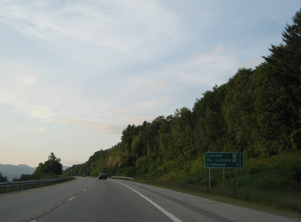
| Exit 30 departs Interstate 93 north as Barron Mountain (elevation 1,499 feet) comes into view. U.S. 3 stays west of the freeway through Woodstock and North Woodstock to Exit 32. 06/27/12 |
|
| I-93 crosses the Pemigewasset and veers west around Barron Mountain beyond this shield assembly. 07/29/07 |
|
| Upcoming Exit 32 serves both North Woodstock and Lincoln in four miles. Lincoln is now 25 miles to the north. 07/29/07 |
|
| Majestic Franconia Notch and Cannon Mountain spread along the northern horizon from the Pemigewasset River valley. 07/29/07 |
|
| NH 175 (Eastside Road) passes underneath I-93 to run along the west side of I-93 to Tripoli Road and adjacent Exit 31.
This guide sign was replaced by 2014. 07/29/07, 10/06/14 |
|
| Tripoli Road stems east from NH 175 and the diamond interchange (Exit 31) with Interstate 93 to Thornton Gap between Mount Tecumseh and Mount Osceola into Waterville Valley. 06/27/12, 10/06/14 |
|
| Interstate 93 kinks west around Russell Crag to traverse the west slopes of Russell Mountain (elevation 2,408 feet). 07/29/07 |
|
| Interstate 93 enters the town of Lincoln just beyond Exit 32 in two miles. The freeway transitions into Franconia Notch Parkway at North Lincoln in three miles.
This distance sign featuring route markers was replaced by 2014 and no longer includes shields. 07/29/07, 06/27/12 |
|
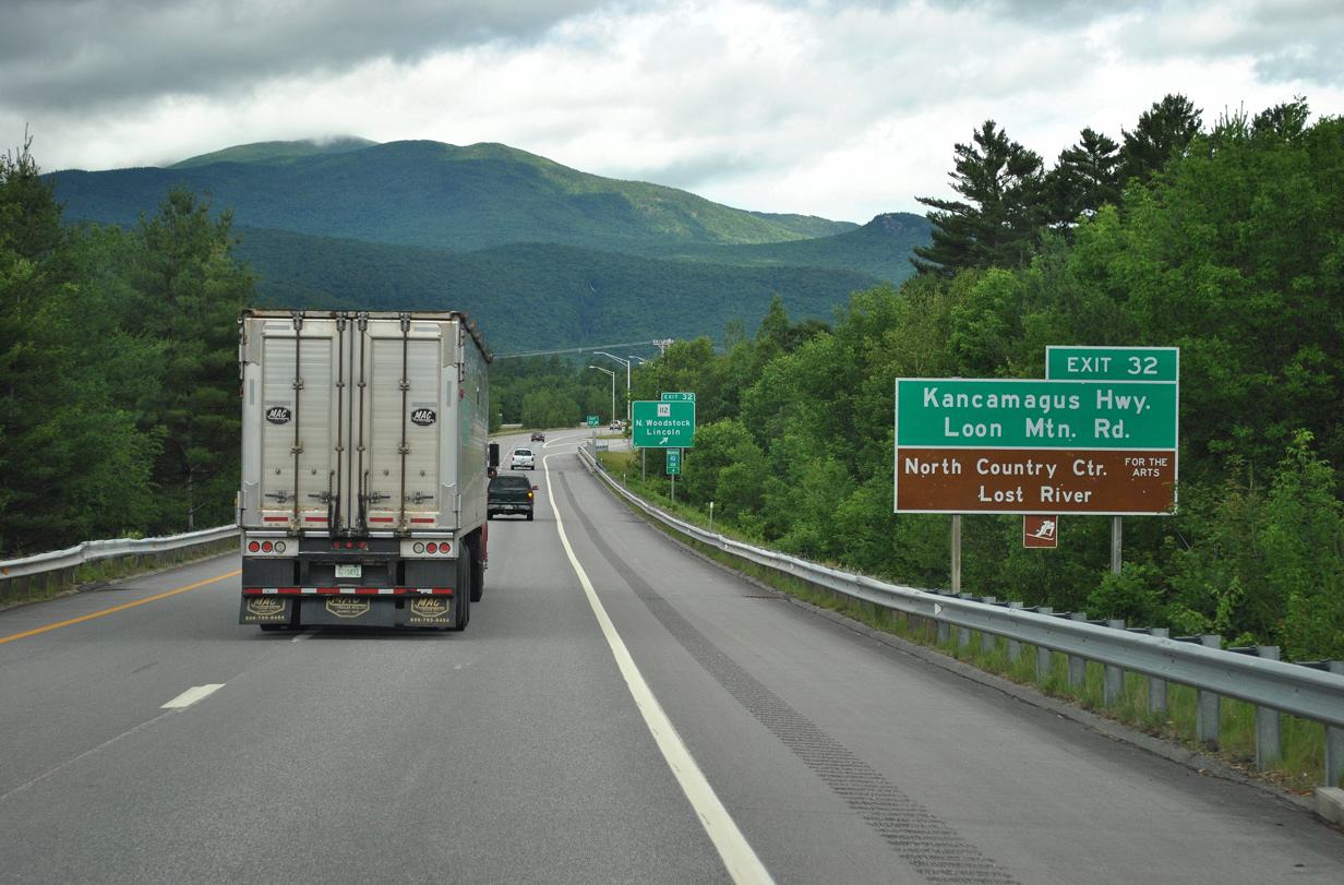
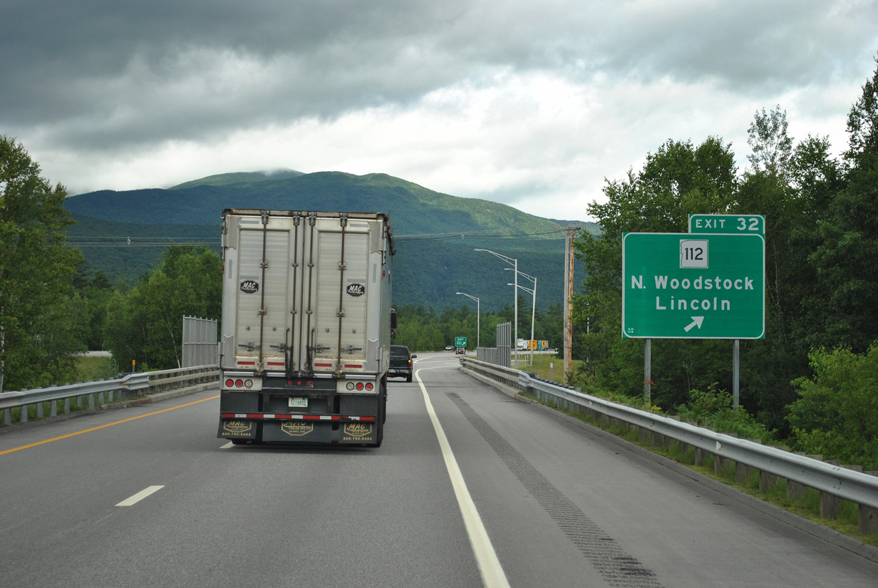
| NH 112 (Kancamagus Highway) and Interstate 93 come together at a folded diamond interchange (Exit 32) between North Woodstock and Lincoln in one half mile. 10/06/14, 06/27/12 |
|
| NH 112 doubles as the Kancamagus Highway east to Loon Mountain ski area, Mount Kancamagus (elevation 3,698 feet) and NH 16 (White Mountain Highway) at Conway.
This guide sign was removed by 2014, with a replacement posted 0.75 miles ahead of Exit 32. 06/27/12 |
|
| Northbound at Exit 32 for NH 112. Lincoln represents the last array of traveler services along I-93 north until Littleton. 06/27/12, 10/06/14 |
|
| Advancing northward along Interstate 93 toward Cannon Mountain (elevation 4,100 feet). 07/29/07 |
|
| Littleton is a 22 mile drive north from North Lincoln beyond Franconia Notch. 07/29/07 |
|
| U.S. 3 stays west of the Pemigewasset River from North Woodstock to Exit 33 of I-93 at north Lincoln. 07/29/07 |
|
| Interstate 93 transitions into Franconia Notch Parkway beyond the parclo interchange (Exit 33) with U.S. 3 (Daniel Webster Highway). The parkway retains four overall lanes to the merge with U.S. 3 in Franconia Notch State Park.
This sign bridge was removed by 2011 and replaced with separate ground level signs for both Exit 33 and Franconia Notch Parkway. 07/29/07 |
|
| U.S. 3 provides a local route north through Lincoln to Indian Head resort, Shadow Lake and Franconia Notch State Park.
A replacement of this sign added mileage figures for Woodstock and Lincoln. 07/29/07 |
|
| Interstate 93 (Franconia Notch Parkway) overtakes the original alignment of U.S. 3 north from a wye interchange (Exit 34A on southbound) within Franconia Notch State Park. 07/23/00 |
|
| Franconia Notch Parkway winds north to a set of ramps beyond milepost 108 for Trailhead Parking to Bridle Path and Falling Waters. For the duration of the parkway, the freeway narrows to two lanes and loses its Interstate-standard construction, with narrower shoulders. The freeway is a Super Two, with no intersections and brown guide signs. For route continuity, Interstate 93 shields are placed alongside the dominant U.S. 3 marker for the length of the parkway. 07/23/00 |
|
| Northbound Franconia Notch Parkway near the Boise Rock turn-off. Franconia Notch is famous for the "Old Man of the Mountain," a rock formation that resembled a man's visage, with sharp, chiseled features including a pronounced chin atop Cannon Mountain. Motorists passing through would need to stop at one of the turnouts and use binoculars to clearly see the features of the Old Man. Sadly, in the early morning hours of May 3, 2003, the rock formation collapsed, despite years of tending to the fragile rock formation. The cause of the collapse was natural forces. The old man's face is present everywhere in New Hampshire, including the state route signs and the state quarter. 07/23/00 |
|
| U.S. 3 finally parts ways from Interstate 93 at a wye interchange (Exit 35) by Bickford Mountain. The US highway begins its northeasterly journey into the remote stretches of northern New Hampshire, passing through Twin Mountain, Whitefield, Lancaster, Stratford, and Colebrook en route to Connecticut Lakes. U.S. 3 enters Quebec at a remote point within the Connecticut Lakes State Forest, where it transitions into Quebec Provincial Route 257. 07/23/00 |
|
| Interstate 93 turns west to enter the town of Franconia at the modified diamond interchange (Exit 36) with NH 141 (Butterhill Road). NH 141 connects U.S. 3 south with I-93 north as part of a 2.18 mile route west to NH 18.
Sign replacements for Exit 36 removed the reference for U.S. 3 north to Twin Mountain. 07/23/00 |
|
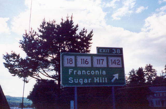
| Exit 38 with Easton Road in Franconia serves four different state routes: NH 18, 116, 117, and 142. There are not many states that would show four route shields on one sign such as this to avoid motorist confusion. NH 18 parallels Interstate 93 through Littleton and Franconia. NH 116 leads southwest toward Easton and Haverhill before merging with NH 18 en route to Littleton. NH 117 leads due west into Franconia, then past Sugar Hill to its western terminus at U.S. 302 near Lisbon. NH 142 leads northeast to Bethlehem and Whitefield, meeting NH 116 again along the way. 07/23/00 |
|
| Gardner Mountain (el. 2,306 ft) and Scarritt Hill (el. 1,732 ft) rise to the west as Interstate 93 lowers toward the crossing over Moore Reservoir beyond milepost 128. 03/02/15 |
|
| Interstate 93 turns north along the west side of Moore Reservoir to a parclo interchange (Exit 44) with NH 18 & 135 (St. Johnsbury Road). NH 18 & 135 combine just south of Exit 43 to parallel the freeway 5.7 miles westward. 03/02/15 |
|
| NH 135 winds west around the periphery of Gardner Mountain, mirroring the course of the Connecticut River south to the Monroe town center. NH 18 (Franconia Road) branches north to remain alongside I-93 to Lower Waterford, Vermont. 03/02/15 |
|
| Spanning the Connecticut River, Interstate 93 enters Caldeonia County, Vermont on the ten mile drive to St. Johnsbury. Quebec Canada lies 63 miles away via I-91 north from the end of I-93. 03/02/15 |
|
| The Connecticut River separates Vermont and New Hampshire north from the Massachusetts state line to Beecher Falls and Clarksville. The 410 mile long waterway originates at Fourth Connecticut Lake in northern New Hampshire. 03/02/15 |
Page Updated 03-03-2015.

 North
North


 North - Franconia Notch Parkway