|
| One mile north of the first Massachusetts interchange (Exit 60) on Interstate 95 south at the NH 107 (New Zealand Road) overpass at Seabrook. Route 286 continues NH 286 west along Pike and Main Streets through the Town of Salisbury. 06/28/05 |
|
| Nearing the Massachusetts state line and the wye interchange (Exit 6) with Interstate 95 Connector to Route 286 (Main Street). Route 286 travels east of I-95 along Main Street to U.S. 1 (Lafayette Road) via Pike Street. The state route becomes NH 286 en route to South Seabrook and Seabrook Beach on the Atlantic Ocean. 06/28/05 |
|
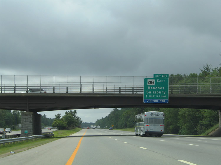
| Exit 60 also serves the Massachusetts Welcome Center along Interstate 95 south. The ramp to Route 286 circumvents the rest area before joining Interstate 95 Connector south ahead of the intersection with Route 286 (Main Street). The connector continues south from Main Street directly onto U.S. 1 (Lafayette Road) to the Salisbury town center. 06/28/05 |
|
| Route 286 ends a 1.46 mile route west from the state line at the loop ramp onto I-95 south from Main Street. Main Street continues west to become Monroe Street into Amesbury. 06/28/05 |
|
| The Massachusetts welcome sign posted adjacent to the tourist information center and rest area at Exit 60. 06/28/05 |
|
| Drivers departing the rest area are provided with the option to return to Interstate 95 or join Exit 60 for Interstate 95 Connector south to Route 286 (Main Street). 06/28/05 |
|
| I-95 quickly encounters the split with Interstate 495 south at Exit 59. I-495 is the outer Boston bypass south to Haverhill, Lawrence, Lowell, Westborough at I-90 and Mansfield at I-95. 06/28/05 |
|
| Interstate 495 travels 11 miles west to Haverhill and 16 miles to the Route 213 freeway at Methuen. I-495 provides the most direct route to Interstate 90 (Massachusetts Turnpike) west to Worcester, Springfield, and Albany, New York at Exit 22. 06/28/05 |
|
| I-495 south connects with Haverhill at Exits 52, 51, 50, and 49 and Lowell at Exits 38, 37, 36 and 35. I-95 and I-495 travel through the Essex National Heritage Area here. 06/28/05 |
|
| Interstate 495 heads two miles west to Amesbury on the 121.56 mile course to Wareham near Buzzards Bay and Cape Cod. Interstate 90 lies 62 miles to the southwest. 06/28/05 |
|
| Exit 59 is a wye interchange. 06/28/05 |
|
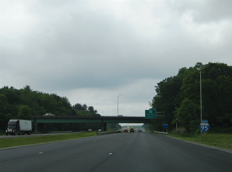
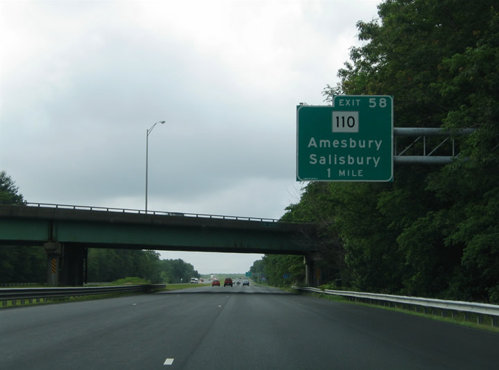
| Route 110 (Elm Street) crosses paths with Interstate 95 just south of I-495 along the Amesbury and Salisbury Town lines. 06/28/05 |
|
| Route 110 splits with Elm Street for Macy Street while en route to I-495 south and Route 150 (Hillside Avenue). Elm Street continues northwest to the Amesbury town center. 06/28/05 |
|
| Exit 58 comprises a parclo interchange between Interstate 95 and Route 110 (Elm Street). Route 110 travels west along Interstate 495 from Amesbury to Merrimac and Haverhill. Eastward, the state route travels to the Salisbury Town center, ending there at U.S. 1 (Bridge Road) near Route 1A (Beach Road). 06/28/05 |
|
| Interstate 95 spans the Merrimack River over the John G. Whittier Bridge. The arch-truss bridge travels 1,346 feet across the river below. Built in the 1950s as part of a relocated U.S. 1, the bridge and associated freeway became part of Interstate 95 in 1956.1 06/28/05 |
|
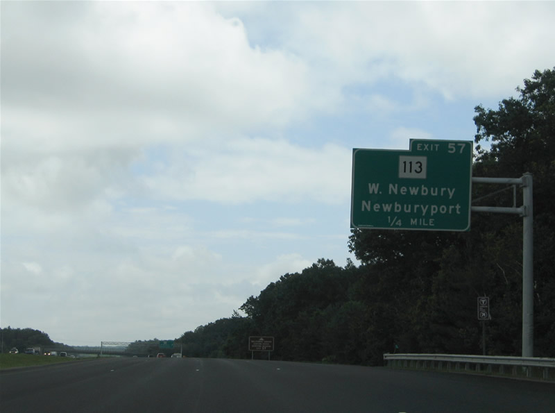
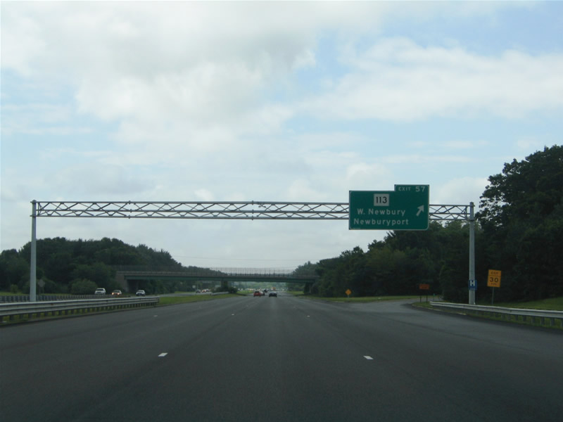
| Exit 57 with Route 113 (Storey Avenue) is next in the city of Newburyport. Route 113 commencts a 50.53 mile route west to Pepperell along High Street and Storey Avenue from Route 1A (High Street) at the Winter and Summer Street connectors to U.S. 1. 06/28/05 |
|
| One quarter mile north of the diamond interchange (Exit 57) with Route 113 (Storey Avenue). Storey Avenue east serves interests to the Newburyport Historic Seaport, Custom House and Maritime Museum among other Newburyport points of interest. 06/28/05 |
|
| Route 113 east to Route 1A south leads to Newbury and Plum Island. Route 113 (Storey Avenue) west heads five miles to West Newbury along Main Street.
West Newberry, a town of 4,235 (2010 census), is the noted hometown of WWE wrestler John Cena. 06/28/05 |
|
| The next two interchanges on Interstate 95 south serve the Town of Newbury. The majority of Newbury lies east of I-95 along U.S. 1 and Route 1A between Byfield and the Atlantic Ocean. 06/28/05 |
|
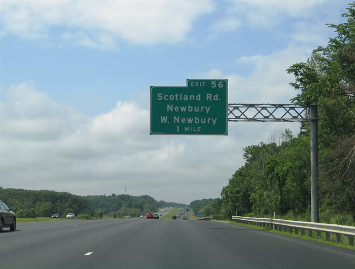
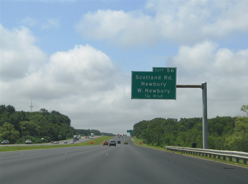
| Scotland Road meanders southwest from Newburyport to Interstate 95 at Exit 56. South Street extends the road west from I-95 to Byfield. 06/28/05 |
|
| Traveling by Turkey Hill, I-95 advancing to the diamond interchange (Exit 56) with Scotland Road and South Street. Byfield lies two miles to the south via South and Main Streets in western Newbury. 06/28/05 |
|
| South Street west to nearby Indian Hill Street leads four miles to Route 113 (Main Street) at West Newbury. Scotland Road east heads to Downfall Wildlife Management Area and Parker Street at Newburyport. 06/28/05 |
|
| Southbound Interstate 95 reassurance marker posted after the on-ramp from Scotland Road. 06/28/05 |
|
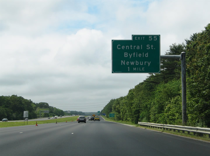
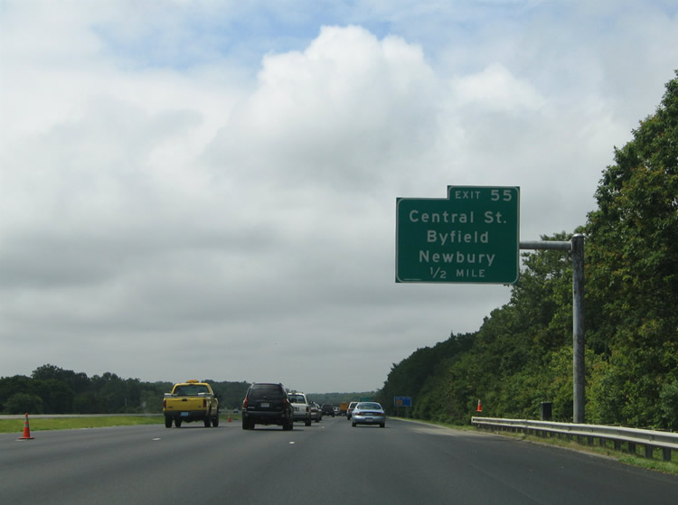
| A diamond interchange links I-95 with Central Street at Byfield in western Newbury. Central Street provides a connection to Main Street in Byfield and Orchard Street east to Downfall Wildlife Management Area and central Newbury. 06/28/05 |
|
| Central Street travels 1.75 miles southeast from Exit 5 to Elm Street in rural south Newbury. 06/28/05 |
|
| Exit 55 leaves I-95 south for Central Street and Byfield. Central Street ties into Main Street just west of the freeway, with Main Street south becoming North Street en route to Georgetown. 06/28/05 |
|
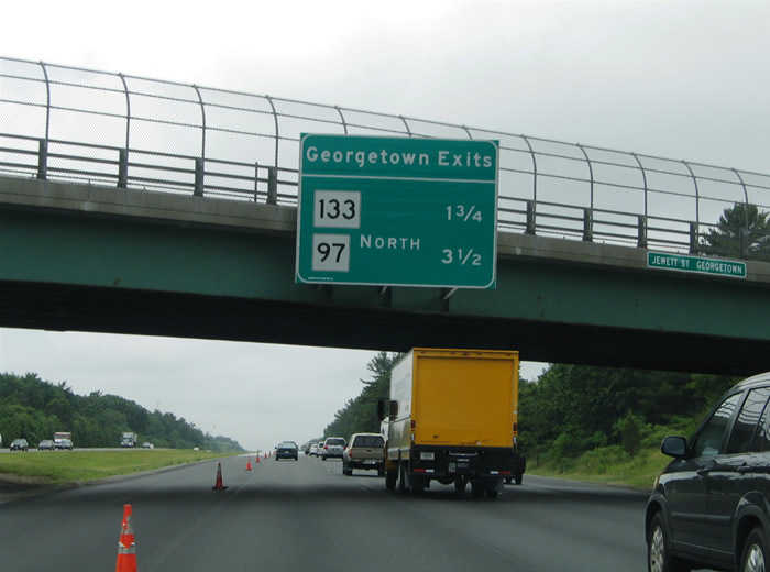
| Interstate 95 enters the town of Georgetown ahead of Exit 54 and after the Parker River. Georgetown lies at the cross roads of Route 97 (Central Street) and Route 133 (Main Street). 06/28/05 |
|
| Route 133 (Main Street) runs two miles southeast from the Georgetown town center to the parclo interchange at Exit 54. The state route continues east three miles to U.S. 1 (Newburyport Turnpike) and five miles to Route 1A at Rowley. 06/28/05 |
|
| Route 133 (Main Street) west leads all the way to North Andover and Lowell while eastward combines with Route 1A from Rowley to Ipswich. The state route continues east from Ipswich five miles to Essex. 06/28/05 |
|
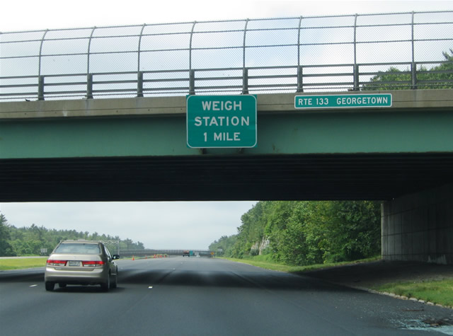
| Truck weigh stations line both sides of Interstate 95 one mile south of Exit 54. 06/28/05 |
|
| Interstate 95 crosses the Boxford town line ahead of the junction with Route 97 (Killam Hill Road). The next three interchanges serve Topsfield along Interstate 95 south. 06/28/05 |
|
| Southbound reassurance marker placed at the truck weigh station within Georgetown Rowley State Forest. 06/28/05 |
|
| Route 97 (Killam Hill Road) heads south from Central Street and Georgetown to meet Interstate 95 at a six-ramp parclo interchange (Exit 53). 06/28/05 |
|
| Route 97 (Killam Hill Road) advances three miles north to Route 133 at the Georgetown town center. The state route continues from there through Haverhill to Salem, New Hampshire. 06/28/05 |
|
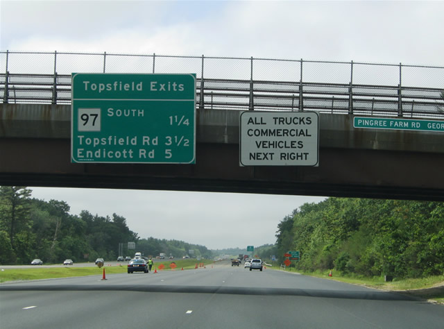
| Route 97 proceeds southeast from Exit 53A three miles to the Topsfield town center, also serving the Topsfield Fairgrounds. 06/28/05 |
|
| Continuing south, Interstate 95 next meets Topsfield Road at Exit 52. Topsfield Road travels northwest to Boxford and east to Washington Street and Topsfield. 06/28/05 |
|
| Interstate 95 is an eight lane freeway through Topsfield, despite the rather rural nature of the area. Topsfield is centered around the cross roads of Route 97 and U.S. 1 east of the freeway. Topsfield Road transitions into Boxford Road and Washington Street en route to Route 97 (Main Street). 06/28/05 |
|
| Exit 52 leaves Interstate 95 southbound for Topsfield Road. Topsfield Road angles northwest 1.2 miles to Elm and Main Streets at the Boxford town center. 06/28/05 |
|
| Endicott Road stems southwest from Topsfield to a diamond interchange (Exit 51) with I-95 in south Boxford. 06/28/05 |
|
| Endicott Road travels north as Washington Street in Topsfield and south as East Street within the Town of Middleton. 06/28/05 |
|
| Endicott Road and East Street proceed 2.4 miles southwest from Exit 51 to Route 62 (Maple Street). Route 62 leads west 1.25 miles to Route 114 (Main Street) at the Middleton town center. 06/28/05 |
|
| I-95 converges with the U.S. 1 corridor at Danvers between Exits 51 and 50. The two parallel routes continue south to Route 128 (Yankee Division Highway), which encircles metro Boston. Signs posted along Interstate 95 advise motorists to remain on the freeway for Route 128 in lieu of parallel U.S. 1 south through Danvers and Peabody. 06/28/05 |
|
| U.S. 1 (Newbury Street) meets Interstate 95 at intertwined wye interchanges (Exit 50) in northwest Danvers. The US highway runs south from Boston Street in Topsfield by Rea Farm Hill to split into separate roadways at Exit 50. South of the freeway, U.S. 1 upgrades to an expressway to a cloverleaf interchange with Route 62 (Maple Street). 06/28/05 |
|
| Route 114 (Andover Street) is accessible from U.S. 1 (Newbury Street) south. Route 114 travels three miles south from the Middleton town center to I-95 at Exit 47 (northbound only). The state route continues two miles southeast into Peabody. 06/28/05 |
|
| U.S. 1 follows an older expressway alignment predating the construction of I-95 through west Danvers and west Peabody. I-95 temporarily followed U.S. 1 between Route 128 (Exit 44) and Exit 50. Construction of the parallel freeway between Exits 50 and 46 occurred between 1969 and 1975.1 06/28/05 |
|
| U.S. 1 (Newbury Street) meets Route 62 (Maple Street) and Route 114 (Andover Street) within the next 2.5 miles. Route 62 travels between Beverly, Danvers and Middleton locally. Route 114 runs southeast from Peabody to Salem and Marblehead. 06/28/05 |
|
| Exit 48 joins southbound Interstate 95 and Centre Street at Danvers. Centre Street has a cloverleaf interchange with U.S. 1 (Newbury Street) at Armory Road nearby. 06/28/05 |
|
| The southbound off-ramp ties into the U.S. 1 northbound loop ramp to Centre Street. Centre Street travels between Armory Road at U.S. 1 to Collins and Hobart Streets in the city of Danvers. Hobart Street leads eastward to Downtown. 06/28/05 |
|
| An advance sign gives notice to vehicles carrying hazardous cargo to remain on Interstate 95 south in lieu of the Interstate 93 Big Dig tunnels through Downtown Boston. 06/28/05 |
|
| Motorists bound for Danvers via Centre Street or Dayton Street north to Middleton depart Interstate 95 south at Exit 48. The loop ramps from Armory Road to U.S. 1 tie into the expressway midway between Route 62 and 114. 06/28/05 |
|
| The next southbound departure point lies 1.50 miles ahead at the wye interchange (Exit 46) with the connector to U.S. 1 at Peabody. U.S. 1 acted as the main road north from Route 128 (Yankee Division Highway) to Interstate 95 north at Exit 46 from 1975 to 1988. The link between 1975-completed Interstate 95 (Exit 46 northward) and the Yankee Division Highway was designed in 1984 to reflect the 1972 cancellation of the Northeast Expressway alignment of I-95 through Lynn. Construction took four years and included realignment of Route 128.1 06/28/05 |
|
| Interstate 95 south continues with three lanes directly onto Route 128 west. Exit 46 provides a two-ramp connector onto U.S. 1 south through the commercial strip to Lynnfield.
All diagrammatic signs for Exit 46 were replaced by 2011. 06/28/05 |
|
| I-95 shifts southeast toward central Peabody and Route 128 (Yankee Division Highway) west to Waltham while U.S. 1 continues southward to Saugus, Malden and Boston. 07/28/07 |
|
| U.S. 1 (Newbury Street) proceeds eight miles south to the Northeast Expressway at Revere and 13.5 miles to the Charlestown section of Boston. I-95 next meets U.S. 1 at Dedham (Exit 15) where the two routes combine east to Exit 12. 07/28/07 |
|
| Interstate 95 southbound on the 1.5 mile segment completed in 1988 between Exits 46 and 45. 07/28/07 |
|
| A wide directional-T interchange joins I-95 and Route 128 (Yankee Division Highway) at Exit 45. The Yankee Division Highway constitutes a belt line freeway through the outer suburbs of Boston between Gloucester and Braintree.
Signs for Exit 45 were changed by 2011 to reflect the removal of Route 128 along I-95 south. 07/28/07 |
|
| Route 128 formerly overlapped with I-95 south from Exit 45 at Peabody to I-93/U.S. 1 (Exit 12) at Canton. The freeway spurs east from Peabody through Danvers to Beverly and Gloucester on the Atlantic Ocean. Exit numbers decreased to 9 along Route 128 east while Exits 8 through 1 were planned for an unconstructed extension north to Pigeon Cove.2 07/28/07 |
|
| Interstate 95 southbound maintains three through lanes onto the Yankee Division Highway west at Exit 45. A two lane off-ramp joins Route 128 east ahead of Exits 28, 26, and 25 for Peabody. The state route travels 18 miles east from I-95 to Gloucester and 20 miles to Route 127 south of Rockport. 07/28/07 |
|
| Forest Street passes over Interstate 95 at Exit 45 and the westward turn to Lynnfield, Wakefield and Waltham. Exit 45 joins a c/d roadway on Route 128 for Exit 28 (Centennial Drive) before joining the freeway mainline ahead of Exit 26 (Lowell Street). 07/28/07 |
Page Updated 02-12-2007.

 South
South