|
| The loop ramp from I-695 west at Exit 4 joins I-895 Spur Branch A at the southbound beginning of Interstate 97. A wye interchange follows connecting the Baltimore Beltway east with I-97. 01/04/19 |
|
| Interstate 97 spans Furnace Branch Road at the first confirming marker posted southbound. A companion trailblazer references the connection to U.S. 301 south for Governor Nice Bridge toward Richmond, Virginia. U.S. 301 originally extended north along MD 3 and MD 2 into Baltimore. 12/21/22 |
|
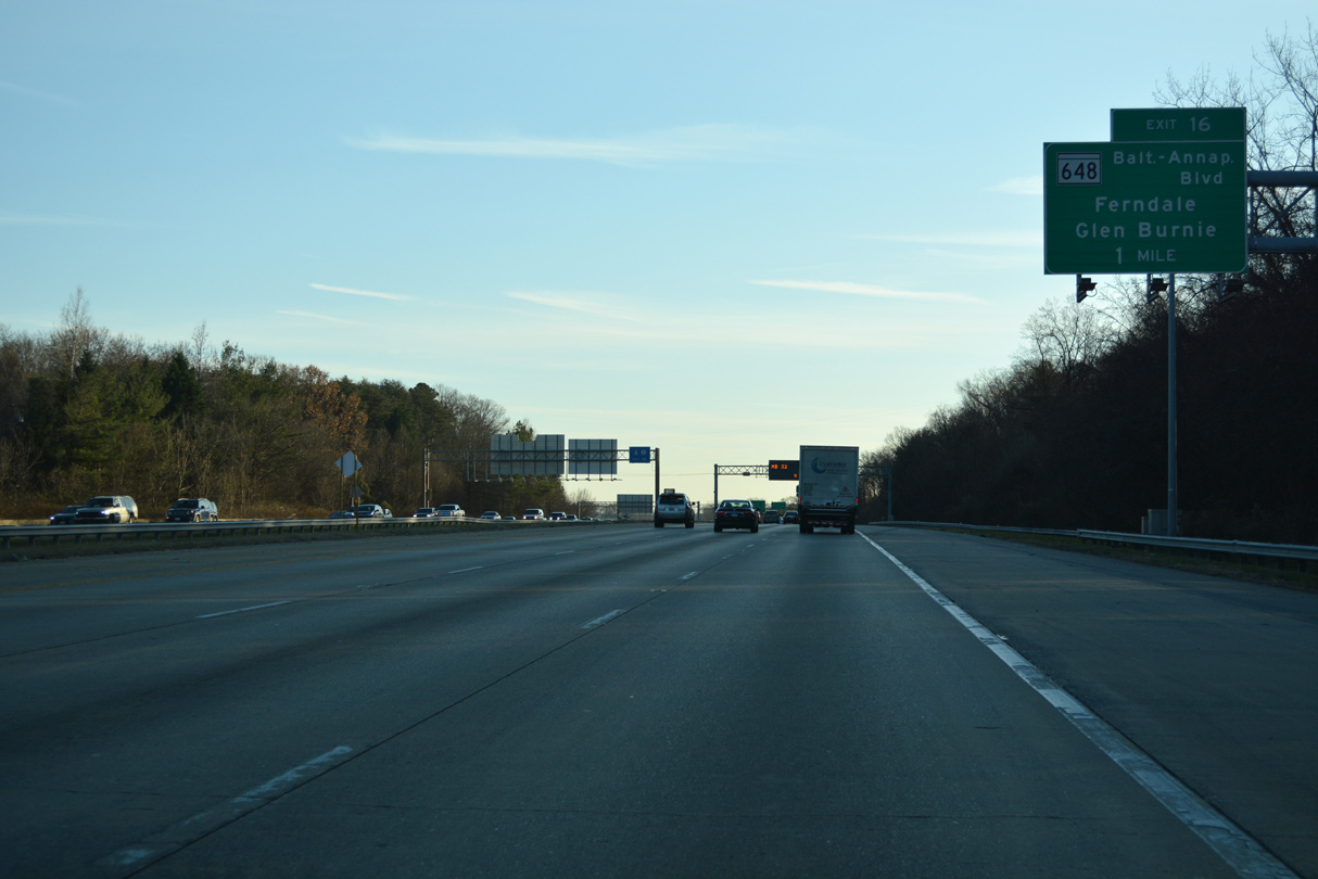
| Exit 16 connects Interstate 97 south with MD 648E (Baltimore-Annapolis Boulevard) at Ferndale. 12/21/22 |
|
| Removed by 2021, a second reassurance marker for Interstate 97 appeared along southbound between North County High School and the Pleasantville neighborhood. 01/04/19 |
|
| The 137 miles to Richmond, Virginia for U.S. 301 south follows I-97 to Exit 7 and MD 3 (Crain Highway) to U.S. 50/301. Forthcoming Exit 16 serves the MARC light rail Cromwell Station. 12/21/22 |
|
| The folded diamond interchange at Exit 16 lies a half mile south of the Wellham Avenue overpass. MD 648E (Baltimore-Annapolis Boulevard) angles 1.3 miles southeast to MD 2 (Governor Ritchie Highway) in central Glen Burnie. 12/21/22 |
|
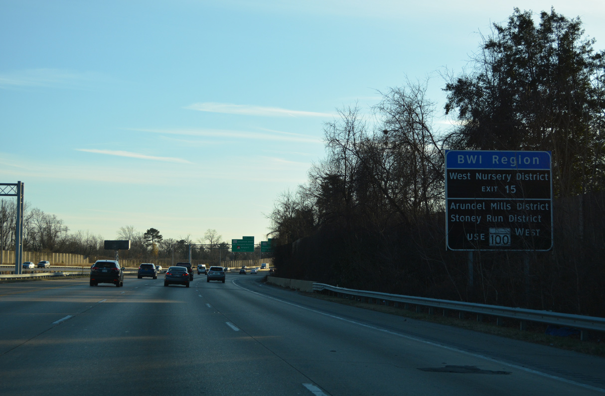
| The Baltimore Washington International Airport Region spreads to the west of Interstate 97. MD 162 (Aviation Boulevard), MD 176 (Dorsey Road) and MD 170 (Aviation Boulevard) comprise the Baltimore-Washington International Airport Loop. 12/21/22 |
|
| 11.15 miles in length, MD 648 north leads to Linthicum Heights, Pumphrey and MD 295 (Russell Street) at Westport. The state route extends southeast to MD 177 (Mountain Road) at Jumpers Hole Road in Glen Burnie. 12/21/22 |
|
| Interstate 97 spans MD 648E (Baltimore Washington Boulevard), a CSX Railroad line and MARC light rail line beyond this shield assembly. 01/04/19 |
|
| MD 162 (Aviation Boulevard) and MD 176 (Dorsey Road) converge just west of Interstate 97. Exit 15 was previously a diamond interchange with just MD 176 (Dorsey Road). 01/04/19 |
|
| Exit 15 links I-97 south with Cromwell Park Drive (MD 162A) west 0.20 miles to parallel MD 162 (Aviation Boulevard). Dorsey Road leads MD 176 west from MD 648 in Glen Burnie to the community of Harmans at MD 170 (Aviation Boulevard). 12/21/22 |
|
| The entrance ramp from MD 176 (Dorsey Road) forms an auxiliary lane south to Exits 14 B/A for MD 100. MD 100 comprises a freeway east to Glen Burnie and west to U.S. 29 at Ellicott City. 12/21/22 |
|
| Southbound I-97 expands to five lanes ahead of the Stewart Avenue over crossing and Exit 14. MD 100 encircles the Baltimore metropolitan area through suburban areas west to Severn and Elkridge and east to Southgate and Pasadena. 12/21/22 |
|
| MD 100 travels east from Exit 14 A, 3.9 miles across Glen Burnie to MD 10. Beyond an overlap with MD 10, MD 100 continues along an expressway to Jacobsville and MD 177 (Mountain Road) near Lake Shore. MD 177 spurs east to Gibson Island along Chesapeake Bay. 12/21/22 |
|
| The directional cloverleaf interchange joining I-97 and MD 100 was reconstructed in the early 1990s. West from Exit 14 B, MD 100 meets MD 295 (Baltimore Washington Parkway) in five miles and I-95 in 7.7 miles. 12/21/22 |
|
| Exit 13 departs just south of the exchange with MD 100 to MD 174 (Quarterfield Road). MD 174 loops northeast from Fort Meade through Severn to Glen Burnie. 12/21/22 |
|
| MD 174 stems 1.77 miles west from MD 3 Business (Crain Highway) in Glen Burnie along Quarterfield Road onto Donaldson Road into the community of Severn. 12/21/22 |
|
| Overall MD 174 runs 5.94 miles west from Glen Burnie to Reece Road at Jacobs Road W ahead of MD 175 (Annapolis Road) and Fort Meade. 12/21/22 |
|
| An auxiliary lane opens south from MD 100 to the folded diamond interchange (Exit 13) with MD 174 (Quarterfield Road). 12/21/22 |
|
| Sound walls line Interstate 97 between the Woodside Square and Glen Burnie Park neighborhoods south of MD 174 (Quarterfield Road). 12/21/22 |
|
| An auxiliary lane opens south to the parclo interchange (Exit 12) with MD 3 Business (Crain Highway). Although MD 3 was superseded by Interstate 97, the bannered route remains posted through Glen Burnie and South Gate. 12/21/22 |
|
| Veterans Highway parallels Interstate 97 south from MD 3 Business (Crain Highway) at Exit 12 to the exchange with MD 3 and MD 32 at Exit 7. 01/04/19 |
|
| MD 3BU extends 0.54 miles southwest from Exit 12 along New Cut Road to a point near Upton Road. New Cut Road continues 2.99 miles from there to Burns Crossing Road. 01/04/19 |
|
| Interstate 97 continues south by Severn Run Natural Environment Area on the ensuing stretch to MD 3/32. The Maryland capital city lies 15 miles to the southeast, followed by the Chesapeake Bay Bridge in 22 miles. U.S. 301 spans the Potomac River 61.4 miles to the southwest via MD 3. 12/21/22 |
|
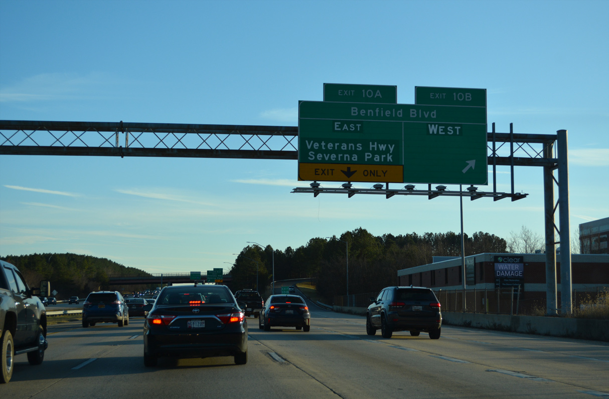
| Benfield Boulevard ties into Interstate 97 one mile south of the Brightview Drive overpass at the community of Severna Park. 12/21/22 |
|
| Veterans Highway continues along the east side of I-97 south from Benfield Boulevard to MD 178 (Generals Highway) and Millersville. 12/21/22 |
|
| Benfield Boulevard intersects Najoles Road just west of Exit 10 B. Najoles Road leads south to Dicus Mill Road and Severn Run Natural Environment Area. 12/21/22 |
|
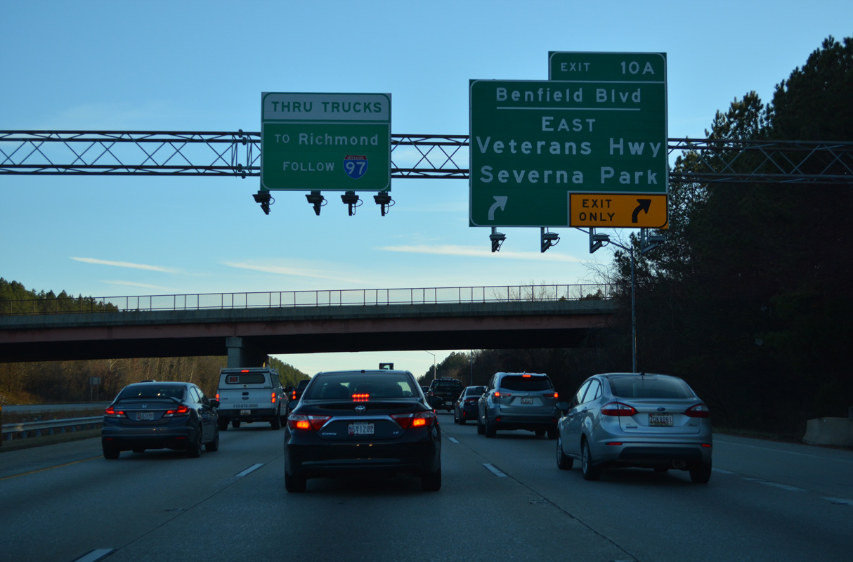
| Exit 10 B leaves I-97 south for Benfield Boulevard west to the I-97 Business Park. A loop ramp follows at Exit 10 A for the arterial east across Severna Park. 12/21/22 |
|
| Benfield Boulevard parallels the Severn River to the north through suburban areas 4.02 miles east from Exit 10 A to Evergreen Road at Robinson Road. 12/21/22 |
|
| Curving southwest from Benfield, Interstate 97 traverses Severn Run Natural Environmental Area and crosses Severn Run. 01/04/19 |
|
| Removed after 2014, the overhead one mile from Exit 7 for MD 3 (Crain Highway) south and MD 32 (Patuxent Freeway) west was replaced with this nondescript sign. 01/04/19 |
|
| MD 3 (Crain Highway) provides a direct route to U.S. 301 south from U.S. 50/I-595 (John Hanson Highway). However the 9.63 mile long arterial route is developed south from Millersville to Crofton. 01/04/19 |
|
| Interstate 97 reduces to four overall lanes on the 7.7 mile long stretch southeast from MD 3/32 to I-595/U.S. 50-301. MD 32 follows a 51.85 mile long arc from Exit 7 to Westminster. 12/21/22 |
|
| The community of Crofton lies north of the Patuxent River and Prince George's County line along MD 3 (Crain Highway). 12/21/22 |
|
| MD 3 (Robert Crain Highway) separates from I-97 south ahead of the cloverleaf interchange with MD 32 (Patuxent Freeway) west to Odenton and Fort George G. Meade. 01/04/19 |
|
| MD 32 constitutes a freeway northwest to I-95 at Savage, U.S. 29 at Columbia and Burntwoods Road at Isaacsville. 01/04/19 |
|
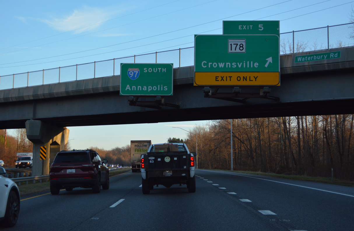
| Interstate 97 overtakes the freeway from the east end of MD 32 on the southeasterly turn from MD 3. MD 178 branches southeast from nearby Veterans Highway at Dorrs Corner to Crownsville beyond Exit 5. 01/04/19 |
|
| A wye interchange joins Interstate 97 south with MD 178 at Exit 5. The off-ramp was once a part of MD 32 before I-97 construction overtook the state route in the mid 1990s. 12/21/22 |
|
| Otherwise MD 178 (Generals Highway) travels 8.06 miles southeast from Veterans Highway to MD 450 (Defense Highway) at Parole. MD 178 to Herald Harbor Road leads to the Herald Harbor along the Severn River. 12/21/22 |
|
| Interstate 97 concludes in five miles at U.S. 50/301 (John Hanson Highway) west of Annapolis. 01/04/19 |
|
| Advancing south from Waterbury, Interstate 97 navigates through a series of S-curves across Bacon Ridge. 12/21/22, 01/04/19 |
|
| Historic Annapolis lies south of U.S. 50/301 along the Severn River and Chesapeake Bay. 12/21/22 |
|
| The ramp for U.S. 50/301 east connects with a collector distributor roadway ahead of Exit 22 for MD 665 (Aris T. Allen Boulevard). 12/21/22 |
|
| A directional T interchange joins the south end of Interstate 97 with U.S. 50/301 in one mile. Interstate 595 is the hidden designation for U.S. 50 (John Hansen Highway) west to I-95/495 (Capital Beltway) and MD 70 / Exit 24 by Annapolis. 12/21/22 |
|
| U.S. 301 accompanies U.S. 50 east across the Chesapeake Bay Bridge to Queenstown on Maryland's Eastern Shore and west to Exit 13 at Bowie. 12/21/22 |
|
| U.S. 50 travels west to Washington, DC and east to Cambridge, Easton and Ocean City. U.S. 301 south heads to Waldorf and LaPlata en route to the Governor Nice Bridge into Virginia. 12/21/22 |
|
| Interstate 97 southbound defaults onto I-595/U.S. 50-301 east. Succeeding exits for MD 665 (Aris T. Allen Boulevard), MD 450 (West Street) and MD 70 (Rowe Boulevard) serve the capital city to the east. 12/21/22 |
|
| Interstate 97 southbound ends at the ramp split to I-595/U.S. 50-301. Washington, D.C. lies 21 miles to the west. The Chesapeake Bay Bridge is 11 miles to the east. 12/21/22 |
|
| Passing under U.S. 50/301 on the eastbound ramp toward Annapolis and the Chesapeake Bay Bridge. 12/21/22 |
Page Updated 02-06-2023.

 South
South