|
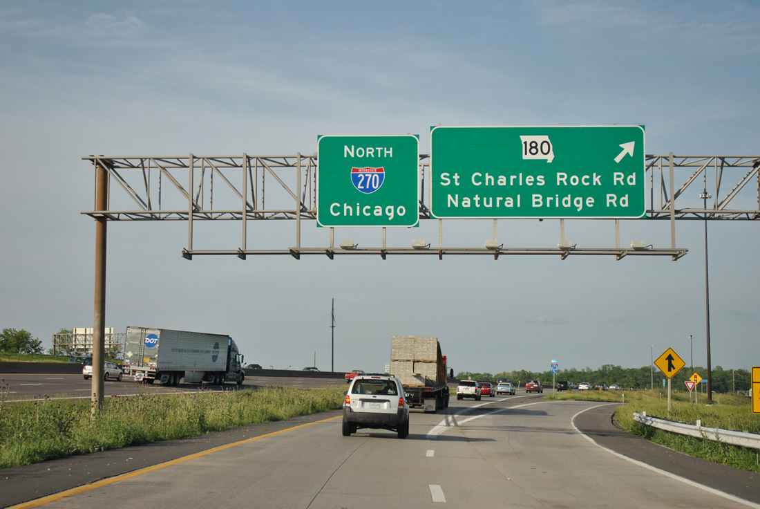
| The ramp from Interstate 70 east to Interstate 270 north includes access to the diamond interchange (Exit 20C) with Missouri 180 (St. Charles Rock Road). 05/03/12 |
|
| Ramps from the I-270 northbound mainline and I-70 east combine ahead of Missouri 180 (St. Charles Rock Road). Natural Bridge Road (Route B) stems east from the state highway nearby to Cypress Road at Lambert International Boulevard to the airport. Natural Bridge and Cypress Road south to Interstate 70 represents the former routing of Missouri 115. St. Charles Rock Road north was a part of MO 115 until 1992, when the Missouri River bridge into St. Charles was closed and removed.1 05/03/12 |
|
| An Interstate 270 trailblazer directs motorists from the I-70 ramp to add a fifth northbound lane onto the freeway mainline. 05/03/12 |
|
| Interstate 270 continues eastward from Bridgeton to a directional T interchange (Exit 22B) with Missouri 370 west to St. Charles and a half diamond interchange (Exit 22A) with Missouri Bottom Road at Hazelwood. 05/03/12 |
|
| The next three exits of Interstate 270 north / east serve the city of Hazelwood. Exit 22A joins Missouri Bottom Road, which leads northwest from U.S. 67 Lindbergh Boulevard) to the St. Louis Outlet Mall area by Missouri 370 - Exit 11. MO 370 comprises a 13 mile freeway west through north Bridgeton and St. Charles to Exit 224 of Interstate 70. 05/03/12 |
|
| Ramps for both the Missouri 370 freeway west and Missouri Bottom Road depart in unison from Interstate 270 north as Gist Road passes overhead. 05/03/12 |
|
| Missouri 370 was designated on April 1, 19932 to replace Missouri 115, which was relocated to the December 16, 1992-opened Discovery Bridge into St. Charles. The freeway west to I-70 was completed on November 20, 1996. 05/03/12 |
|
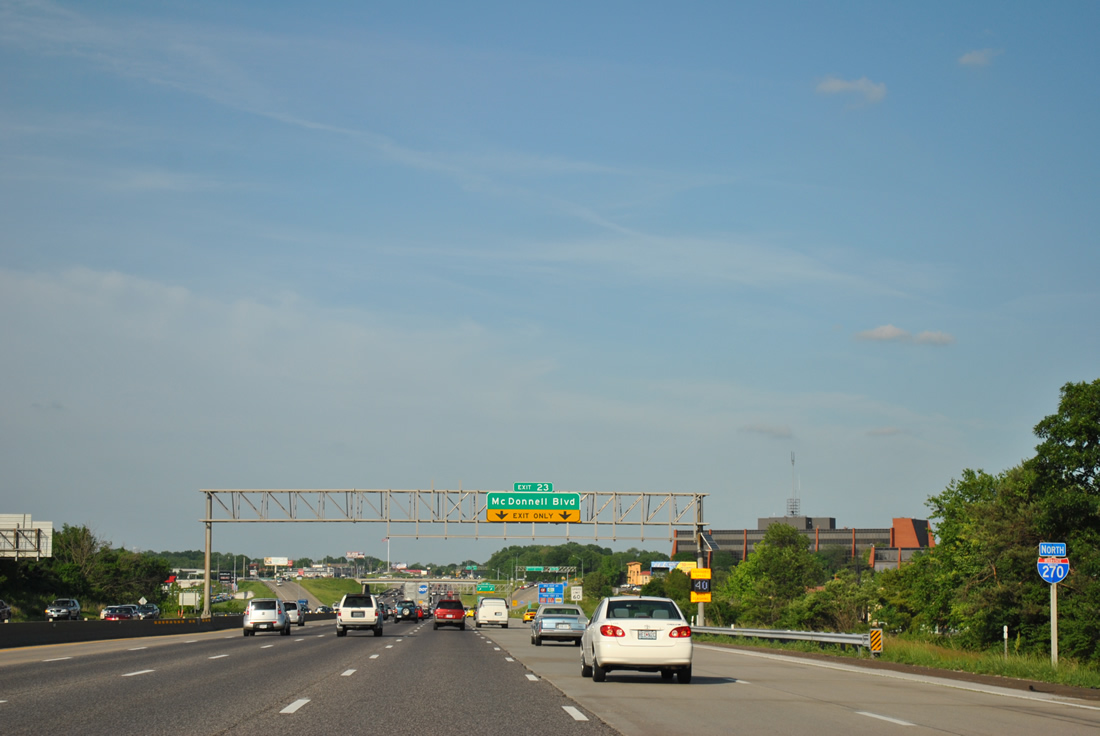
| Traffic from Missouri 370 east joins Interstate 270 north ahead of the Exit 23 diamond interchange with James S. McDonnell Boulevard in Hazelwood. 05/03/12 |
|
| I-270 north briefly swells to six lanes ahead of a two-ramp exit for McDonnell Boulevard. 05/03/12 |
|
| McDonnell Boulevard heads southeast and encircles St. Louis Lambert International Airport (STL) to Brown Road at Berkeley. The road between U.S. 67 (Lindbergh Boulevard) and Brown Road was a part of Highway TT. 05/03/12 |
|
| Exit 23 parts ways with Interstate 270 north for McDonnell Boulevard. North from Exit 23, the arterial becomes Howdershell Road northeast through the residential north side of Hazelwood en route to become Shackleford Road through Florissant. 05/03/12 |
|
| Signs for Interstate 270 shift from north to east cardinal directions after Exit 23. 05/03/12 |
|
| Travel times are indicated along dynamic messages signs placed along all of Interstate 270 in Missouri. 05/03/12 |
|
| U.S. 67 (Lindbergh Boulevard) parallels all of Interstate 270 north from Mehlville through the St. Louis County suburbs before finally crossing paths with the freeway at Exits 25A/B. 05/03/12 |
|
| Exit 25A for U.S. 67 south claims the right lane of Interstate 270 east, which causes a bottleneck during peak hour traffic. 05/03/12 |
|
| Lindbergh Boulevard comprises a multi-lane arterial southward from Hazelwood across STL Airport to Bridgeton and Interstate 70. A 2.1 mile stretch of the route was rerouted during the $1.1 billion Phase 1 expansion to add a third runway to the airport.3 That left a portion of old roadway, including a half diamond interchange, between a section of old Natural Bridge Road (old Highway 115) and Missouri Bottom Road. 05/03/12 |
|
| The relocation of U.S. 67 (Lindbergh Boulevard) underway in fall 2001 included the construction of a tunnel under the new runways. The Lindbergh Tunnel cost $50 million and was constructed as part of the $121 million redesign for 2.1 miles of Lindbergh Boulevard. That work included the building of an interchange with Natural Bridge Road (Highway B).
Construction on the tunnel commenced in December 2002 and was completed by September 27, 2004. Vehicles carrying hazardous cargo are prohibited from using the under crossing per a 2002 law passed by the Missouri Legislature.3 05/03/12 |
|
| Interstate 270 east at Exit 25A to U.S. 67 (Lindbergh Boulevard) south. A loop ramp departs in one half mile from the cloverleaf interchange for the US highway north to Florissant. 05/03/12 |
|
| U.S. 67 arcs eastward 8.2 miles from Exit 25B to the north end of the Missouri 367 expressway, where the route turns north 1.6 miles to the Lewis Bridge across the Mississippi River.
Interstate 270 proceeds east otherwise 0.75 miles to a directional T interchange with Interstate 170 south to Overland, Olivette, University City and Ladue. 05/03/12 |
|
| An eastbound reassurance shield lies ahead of Coldwater Creek along Interstate 270. Pershall Road comprises the south side frontage road from U.S. 67 east to Highway N (New Florissant Road). 05/03/12 |
|
| Interstate 170 begins in one quarter mile and travels 11.2 miles south to I-64/U.S. 40 at Richmond Heights. The freeway was originally numbered Missouri 725 and was completed in 1983. 05/03/12 |
|
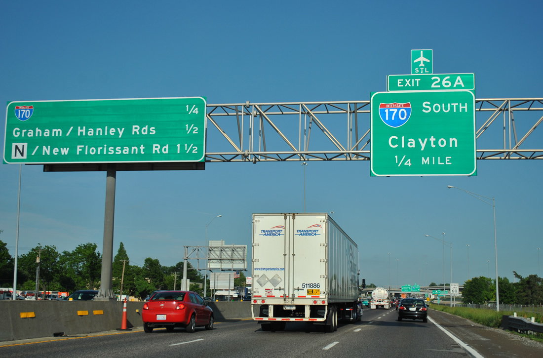
| Traffic crawls beyond the Exit 26A ramp departure for Interstate 170 south to Clayton. The freeway enters Berkeley just south of I-270 and meets Interstate 70 in 3.4 miles. 05/03/12 |
|
| Exit 26B leaves I-270 east from within the I-170 interchange for Hanley Road south to Berkeley and Graham Road north into central Florissant. 05/03/12 |
|
| Ramps for Interstate 170 stack on the south side of I-270. The directional interchange between the two freeways originally had left side movements along I-270 west. 05/03/12 |
|
| Highway N (Florissant Road) stems south from a diamond interchange (Exit 27) with Interstate 270 in three quarters of a mile. 05/03/12 |
|
| The next three interchanges of Interstate 270 serve the city of Ferguson to the south. 05/03/12 |
|
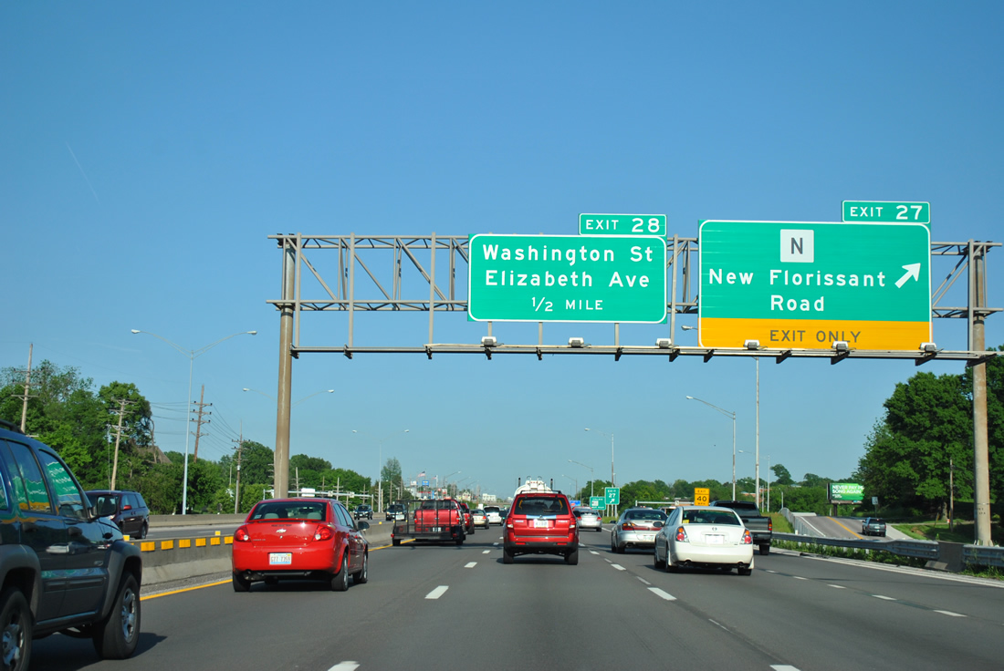
| A lane gained from I-170 north departs for New Florissant Road at Exit 27. Highway N follows Florissant Road south from Interstate 270 through Calverton Park, Ferguson and Interstate 70 at Cool Valley. 05/03/12 |
|
| New Florissant Road extends Florissant Road north from Exit 27 to historic downtown Florissant, ending at U.S. 67 in 2.1 miles. 05/03/12 |
|
| Washington Street south from Florissant and Elizabeth Avenue north from Calverton Park and Ferguson come together at a three-quarter diamond interchange (Exit 28) with Interstate 270. 05/03/12 |
|
| West Florissant Avenue branches south from Highway AC (New Halls Ferry Road) to meet Interstate 270 at the Exit 29 diamond interchange next. 05/03/12 |
|
| Highway AC mixes with Interstate 270 with ramps onto adjacent frontage roads one mile east of the West Florissant Avenue off-ramp. 05/03/12 |
|
| South from Exit 29, West Florissant Avenue continues into Dellwood and southeast Ferguson. The arterial curves southeast from there through Jennings to enter St. Louis at Walnut Park West and North Pointe. 05/03/12 |
|
| Exit 30 leaves Interstate 270 east in one half mile for Highway AC (New Halls Ferry Road). Highway AC travels south from U.S. 67 (Lindbergh Boulevard) to end at the Jennings city line, 2.1 miles to the south. 05/03/12 |
|
| A service road links the Exit 30 off-ramp at Highway AC with Old Halls Ferry Road. Old Halls Ferry Road splits with Highway AC just south of I-270 for a northerly course to the city of Black Jack and U.S. 67 at Shoveltown. 05/03/12 |
|
| Missouri 367, an expressway linking U.S. 67 (Lindbergh Boulevard) and Interstate 270, is 1.75 miles away. Bellefontaine Road (Exit 32) follows in 2.75 miles. 05/03/12 |
|
| Eastbound at the Exit 30 ramp departure to Highway AC and Old Halls Ferry Road. Halls Ferry Road south from Ferguson heads to Jennings and Halls Ferry Circle at the Baden neighborhood of north St. Louis. 05/03/12 |
|
| Missouri 367 was upgraded to an expressway between Interstate 270 and New Jamestown Road officially on October 28, 2006, when the limited access highway opened to traffic.4 Intersections with Dunn Road, Redman Avenue, and Parker Roads were replaced with overpasses. Ramps onto Lusher Road (north) and Benham Road (south) provide movements between Highway 367 and intersecting roads. 05/03/12 |
|
| Again a fourth lane accompanies Interstate 270 east from the Old Halls Ferry Road on-ramp to the cloverleaf interchange (Exits 25A/B) with Missouri 367 (Lewis and Clark Boulevard). 05/03/12 |
|
| Highlighted on this interchange sequence sign are exits all serving the city of Bellefontaine Neighbors. The city of 10,860 (2010 census) lies south of I-270 to Exit 33. 05/03/12 |
|
| Missouri 367 follows old U.S. 67 south along Lewis and Clark Boulevard to Moline Acres, Jennings, and St. Louis. U.S. 67 used Lewis and Clark Boulevard south to Riverview Boulevard, Bircher Boulevard, and Kingshighway Boulevard through the city while U.S. 67 Bypass took the route of Lindbergh Boulevard west to Florissant. 05/03/12 |
|
| Missouri 367 south from Exit 31 consists of an arterial through west Bellefontaine Neighbors. The state highway concludes at Halls Ferry Circle within the St. Louis city limits. 05/03/12 |
|
| Exit 31B loops onto Missouri 367 north to Alton, Illinois. The expressway was extended north from New Jamestown Road to U.S. 67 (Lindbergh Boulevard), where MO 367 ends, between December 2006 and May 2008. That work included adding a diamond interchange between the two routes.5 05/03/12 |
|
| Riverview Drive appears on this sign as the final Missouri exit, 2.5 miles to the east. 05/03/12 |
|
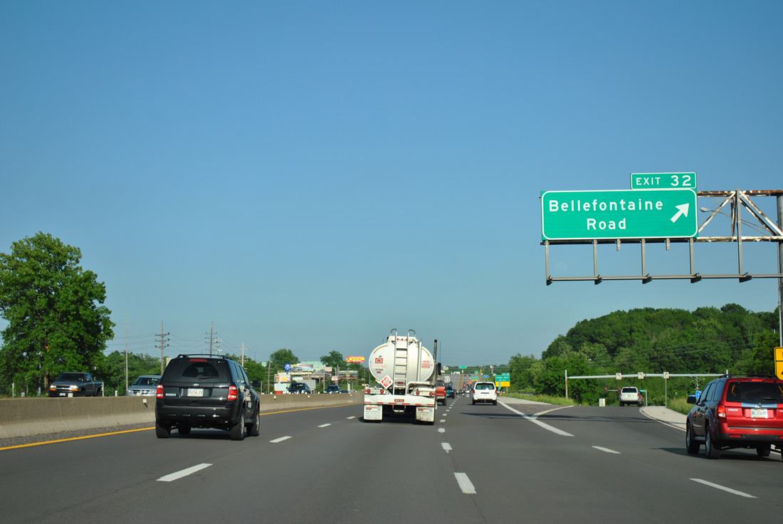
| Exit 32 consists of a diamond interchange with Bellefontaine Road south to Bellefontaine Neighbors and north to Spanish Lake. 05/03/12 |
|
| Bellefontaine Road leads south from Exit 32 through the heart of Bellefontaine Neighbors to become Broadway at the Baden neighborhood of St. Louis. Broadway was a part of City U.S. 66 south from Riverview Drive to Calvary Avenue. 05/03/12 |
|
| Interstate 270 east sheds a lane at the Exit 33 off-ramp to Lilac Avenue on the east side of Bellefontaine Neighbors. 05/03/12 |
|
| Drivers elevate to pass over a Burlington Northern Railroad line leading into the Exit 33 diamond interchange with Lilac Avenue. 05/03/12 |
|
| The left-lane restriction on trucks ends as Interstate 270 reduces to a four lane freeway. Illinois 3 appears on this centerline posted sign as the first exit beyond the Chain of Rocks Bridge. 05/03/12 |
|
| Lilac Drive meanders south from Interstate 270 to a high school and through residential areas to Scranton Avenue in Riverview. Northward, the road ends at Coal Bank Road by Larimore nearby. 05/03/12 |
|
| Interstate 270 reaches the northern strip of St. Louis at Exit 34 with Riverview Drive (Highway H). Riverview Drive represents historic City U.S. 66 southward from Dunn Road, which is a former alignment of both U.S. 66 and U.S. 40 Bypass. 05/03/12 |
|
| A tourist information center lies along adjacent Dunn Road, just west of Riverview Drive and Exit 34 for motorists entering the state from Illinois. Eastbound travelers may access the facility as well. 05/03/12 |
|
| One half mile out from the diamond interchange (Exit 34) with Riverview Drive (Highway H). Exits 3A/B with Illinois 3 at Granite City lies 3.75 miles ahead beyond the Chain of Rocks Canal. 05/03/12 |
|
| Exit 34 departs Interstate 270 east for Riverview Drive. Highway H follows Riverview Drive south through the Riverview section of St. Louis to Hall Street through the North Riverfront area. Columbia Bottom Road extends Riverview Drive northward from the city line to Columbia Bottom Conservation Area. 05/03/12 |
|
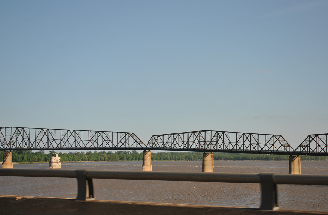
| Motorists immediately cross the New Chain of Rocks Bridge across the Mississippi River from Riverview Drive. Opened in 1966, the steel girder bridge replaced the original Chain of Rocks Bridge to the north. 05/03/12 |
|
| Historic U.S. 66, and later U.S. 66 Bypass, spanned the Mississippi River on the 1929-built Chain of Rocks Bridges. Named for a series of rock ledges along the river below, the steel truss bridge was closed to vehicular traffic in 1970 and now serves as a pedestrian and bicycle bridge and tourist attraction for Historic U.S. 66 enthusiasts.5 Two intake towers rise just south of the bridge ahead of Federal Dam #27. 05/03/12 |
|
| Interstate 270 enters Madison County, Illinois about two thirds of the way across the Mississippi River. The New Chain of Rocks Bridge reaches Chouteau Island and northern reaches of the Madison city limits ahead. 05/03/12 |
Page Updated 03-28-2013.


 North
North