|
| Just beyond the separation from I-75 south, I-275 passes under County Line Road and enters Hillsborough County. 01/18/16 |
|
| Interstate 275 was expanded to six overall lanes between the apex with I-75 and Exit 53 in 2011. Speed limits are posted at 70 MPH on this stretch. 01/18/16 |
|
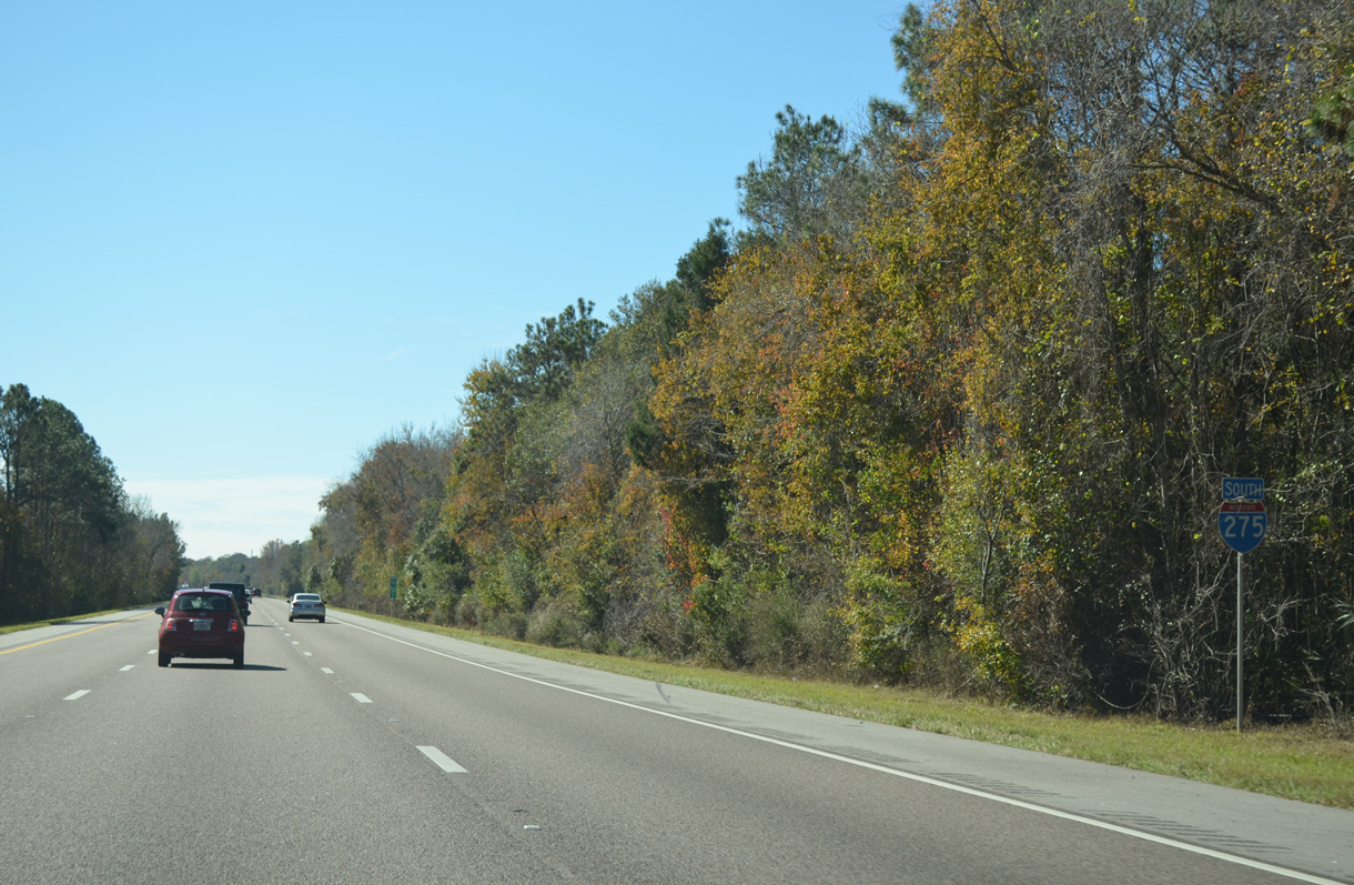
| Despite the attempts by developers to have an additional interchange built, Interstate 275 travels uninterrupted southward 7.3 miles to Bearss Avenue (SR 678). 01/18/16 |
|
| A second shield for Interstate 275 south posted along the exit less stretch through Cypress Creek Preserve west of New Tampa. Presently the only way to access New Tampa is via Bruce B. Downs Boulevard (CR 581) from I-75 or Bearss Avenue east. 01/18/16 |
|
| A button copy sign appears at the Livingston Avenue overpass as Interstate 275 angles southwest by Lutz to Chapman. 01/18/16 |
|
| Passing by a third southbound shield for I-275 posted between the Pasco County line and Exit 53. Several residential roads run by or end next to the freeway on this stretch. 01/18/16 |
|
| Forthcoming Bearss Avenue (SR 678) provides the first connection to both U.S. 41 Business (Florida Avenue) and U.S. 41 (Nebraska Avenue), two highways that parallel Interstate 275 southward into Tampa without direct access. 12/14/15 |
|
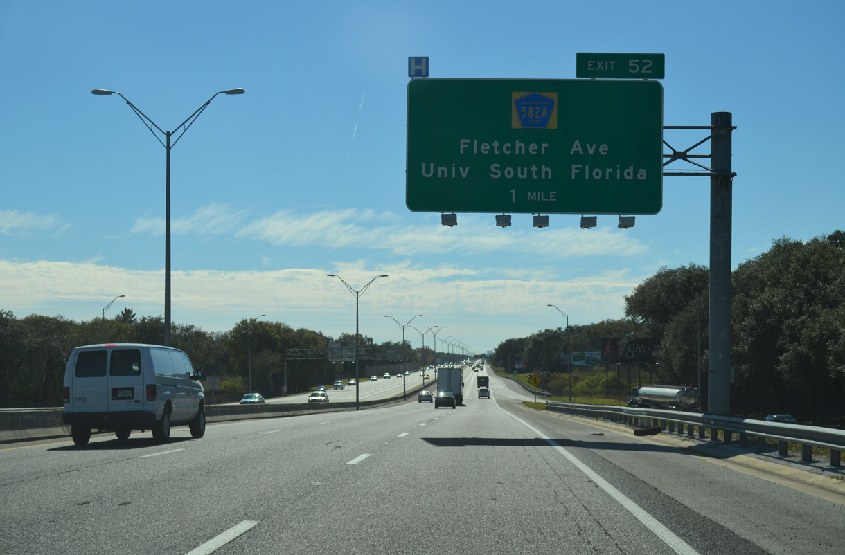
| An interchange sequence sign outlines the distances to Fletcher Avenue (CR 582A / SR 579) and the first two city of Tampa interchanges along Interstate 275 south. 01/18/16 |
|
| Entering the diamond interchange (Exit 53) with SR 678 (Bearss Avenue) on I-275 south. SR 678 overlays the half mile of Bearss Avenue linking U.S. 41 Business (Florida Avenue) and U.S. 41 (Nebraska Avenue). The arterial route extends west to Ehrlich Road and Northdale and east to Bruce B. Downs Boulevard (CR 581) at New Tampa. 01/18/16 |
|
| Fletcher Avenue (SR 579) meets I-275 next at a diamond interchange (Exit 52) in one mile. A mostly unmarked route, CR 582A extends east from U.S. 41 (Nebraska Avenue) to the University of South Florida (USF) and Temple Terrace. Fletcher Avenue west continues as an unnumbered arterial toward Carrollwood. 01/18/16 |
|
| A reassurance marker appears for I-275 south beyond the Bearss Avenue on-ramp. Businesses and residences abut the freeway frontage to the Tampa city line at Fowler Avenue. 08/22/15 |
|
| Interstate 275 southbound reaches Exit 52 to Fletcher Avenue. Like SR 678 previously, SR 579 only lines the stretch of roadway between U.S. 41 Business (Florida Avenue) and U.S. 41. CR 582A continues Fletcher Avenue east to Veterans Hospital, Moffitt Cancer Research Center, USF and Interstate 75 (Exit 266) at Morris Bridge Road (CR 579). 08/22/15 |
|
| State Road 582 (Fowler Avenue) meets Interstate 275 at the succeeding exit southbound. Straddling the Tampa city line east from U.S. 41 Business (Florida Avenue), SR 582 consistutes an eight lane arterial to Bruce B. Downs Boulevard at USF. 08/22/15 |
|
| Interstate 275 spans East 127th Avenue on the approach to Fowler Avenue. 08/22/15 |
|
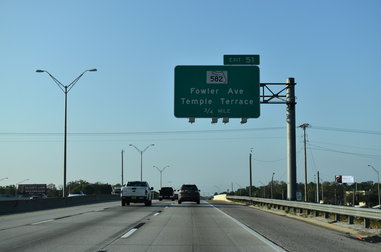
| Exit 51 departs I-275 south for SR 582 (Fowler Avenue). SR 582 travels 7.83 miles overall from U.S. 41 Business (Florida Avenue) and North Tampa to U.S. 301 near Thonotosassa. 08/22/15 |
|
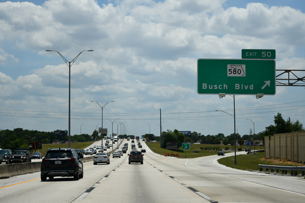
| SR 580 (Busch Boulevard) meets Interstate 275 at a folded diamond interchange (Exit 50) by the Sulphur Springs community of Tampa. The state road connects the freeway with Busch Gardens and Temple Terrace to the east. 08/22/15 |
|
| Sound walls separate Interstate 275 from parallel Central Avenue south to the Bougainvillea Avenue underpass. 08/22/15 |
|
| SR 580 travels east to SR 583 (56th Street North) in Temple Terrace and west to U.S. 19 Alternate in Dunedin. Busch Boulevard carries the state road west from Exit 50 to Dale Mabry Highway (SR 597) in Carrollwood. 08/22/15 |
|
| SR 580 shields posted alongside the southbound off-ramp at Exit 50. One of two routes joining Tampa with Clearwater, State Road 580 measures 28.78 miles in length between Temple Terrace and Dunedin. 08/30/14 |
|
| Interstate 275 winds southward through the Sulphur Springs neighborhood, spanning Yukon Street by this shield assembly. 08/22/15 |
|
| Advancing south through the half diamond interchange (Exit 49 on northbound) with Waters Avenue and Bird Street. The following exit connects with Sligh Avenue in the Old Seminole Heights neighborhood of Tampa. 08/22/15 |
|
| Sulphur Springs Tower rises west of Interstate 275 from Zoo Tampa at Lowry Park. The structure was constructed in the 1930s and originally served as a water tower. 10/07/15 |
|
| I-275 crosses the Hillsborough River one half mile ahead of Exit 48 with Slight Avenue. Sligh Avenue spans the river on its westward course to Lowry Park and unincorporated Egypt Lake-Leto. 08/22/15 |
|
| This shield stands alongside I-275 south beyond the entrance ramp from Bird Street and Waters Avenue. Waters Avenue comprises a busy through route west from Lowry Park to Town 'n' Country. 08/22/15 |
|
| Entering the diamond interchange (Exit 48) with Sligh Avenue along Interstate 275 south. Sligh Avenue continues east through Old Seminole Heights to East Seminole Heights and Rivergrove in Tampa. There are five separate sections of Sligh Avenue between Town 'n' Country and Mango. 08/22/15 |
|
| One half mile north of the parclo interchange (Exit 47) with U.S. 92 (Hillsborough Avenue) on Interstate 275 south. U.S. 41 and 92 combine for 2.25 miles east from the adjacent intersection of Hillsborough and Nebraska Avenues to 40th Street N. 08/22/15 |
|
| Reassurance marker posted ahead of the Hanna Avenue underpass on Interstate 275 south. 08/22/15 |
|
| Southbound Interstate 275 reaches Exit 47 to U.S. 92 (Hillsborough Avenue). U.S. 92 travels west along Hillsborough Avenue to SR 580 (Dale Mabry Highway) at Drew Park. 08/22/15 |
|
| U.S. 41 & 92 follow Hillsborough Avenue east to the Northeast Community. Beyond their split, U.S. 92 continues to Harney and I-4 at Eureka Springs while U.S. 41 drops south to Eastern Heights and Highland Pines. 09/05/15 |
|
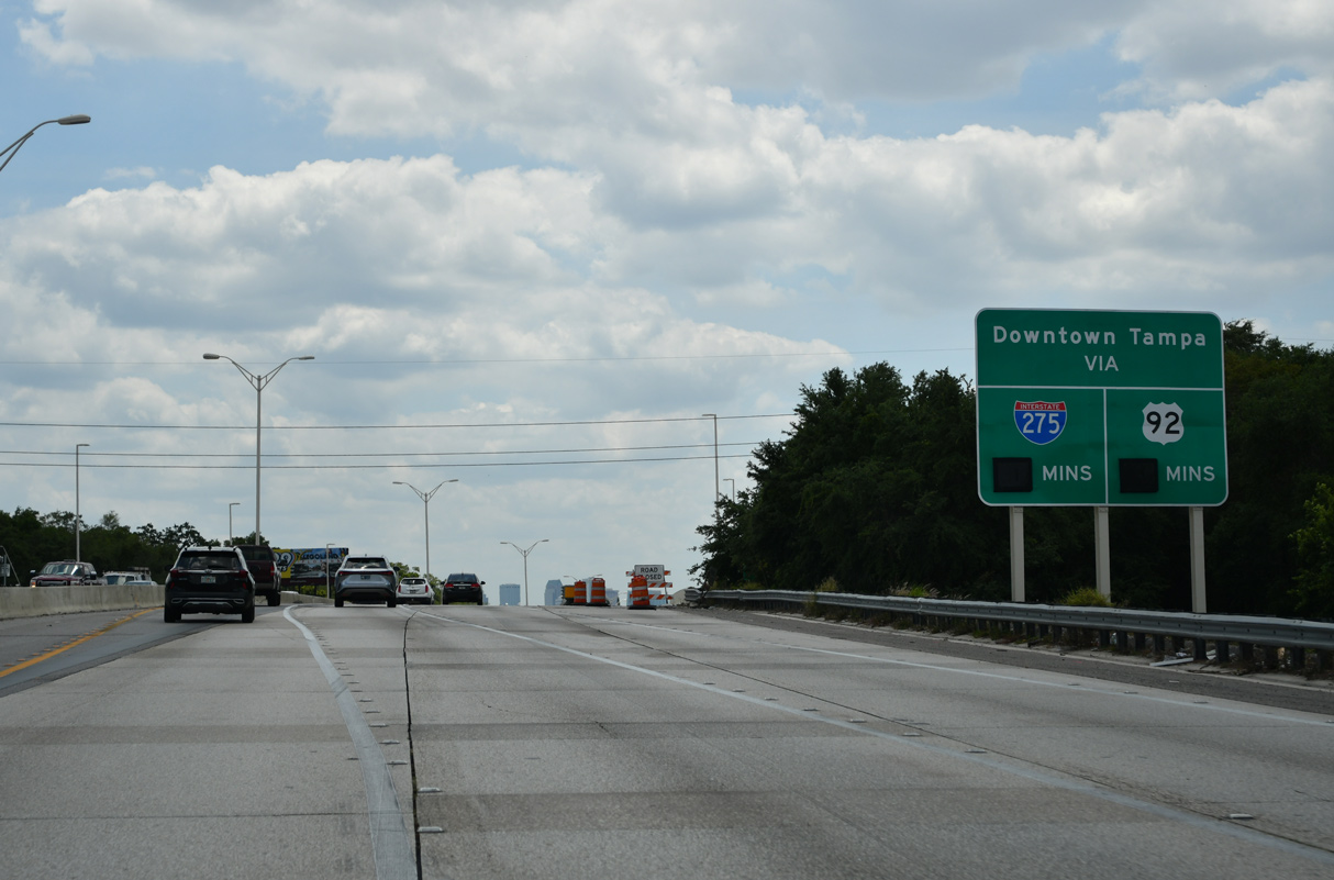
| The first sign for Interstate 4 east appears 1.5 miles north of the Downtown Interchange (Exit 45B). The exchange was reconstructed between October 27, 2002 and December 22, 2006. Enhancements included the relocation of the flyover merge from I-275 south to I-4 east from the left to the right and the separation of the Jefferson Street and Ashley Drive ramps from the freeway mainline. 04/13/18 |
|
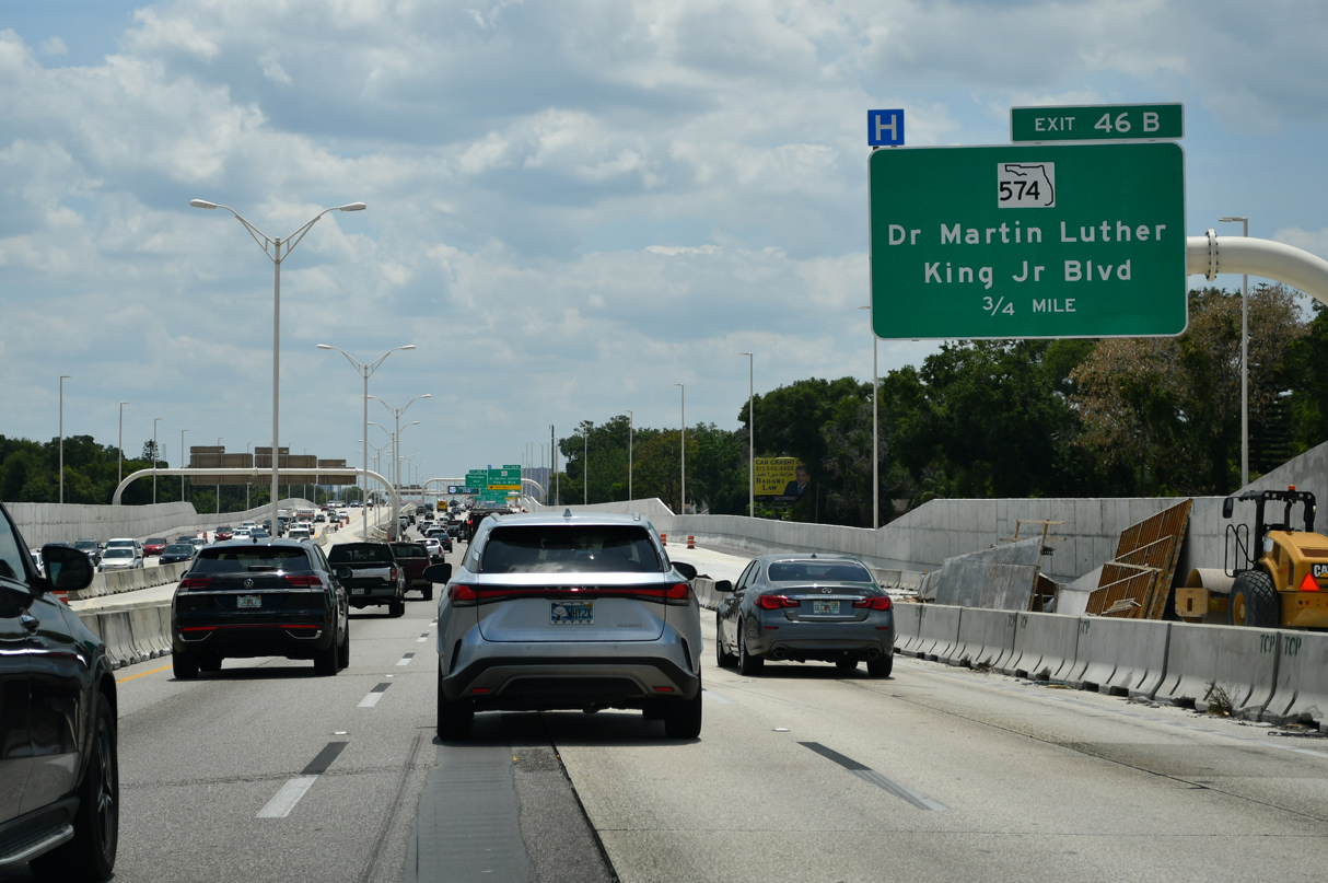
| Interstate 275 passes through the South Seminole Heights neighborhood to Dr. Martin Luther King, Jr. Boulevard (SR 574). 08/22/15 |
|
| Forthcoming SR 574 (Dr. Martin Luther King, Jr. Boulevard) constitutes a 23.04 mile route from U.S. 92 (Dale Mabry Highway) near Drew Park in Tampa east to U.S. 92 at Plant City. Locally the commercial boulevard connects I-275 with Tampa Heights and Ybor Heights. 08/22/15 |
|
| Osborne Avenue passes under I-275 by this reassurance marker east of Hillsborough High School. 08/22/15 |
|
| SR 574 (Dr. Martin Luther King, Jr. Boulevard) west beyond the Hillsborough River leads to Plaza Terrace, Raymond James Stadium (home of the NFL Tampa Bay Buccaneers) and George Steinbrenner Field (spring training home of the MLB New York Yankees). The sports facilities line Dale Mabry Highway south from the end of SR 574. 08/22/15 |
|
| Exit 46B departs Interstate 275 south for Dr. Martin Luther King, Jr. Boulevard. SR 574 comprises a busy commercial boulevard west to Wellswood and the Stadium Area and east to East Tampa, Orient Park and Mango. 08/22/15 |
|
| I-275 continues a half mile south from SR 574 to Exit 45B with I-4. Interstate 4 was reconstructed between 2004-07 from the Downtown Interchange east to the Tampa city line. The six to eight lane commuter freeway heads east to the unincorporated communities of Mango, Seffner and Dover in eastern Hillsborough County. 08/22/15 |
|
| Exit 46A to Floribraska Avenue precedes the Downtown Interchange as a local off-ramp to Tampa Heights and La Paloma. Floribraska Avenue links I-275 with parallel U.S. 41 Business (Florida Avenue / Tampa Street) and SR 45 (Nebraska Avenue). 08/22/15 |
|
| The on-ramp from SR 574 ties into I-275 south beyond the Lake Avenue underpass. Robles Park lines the west side of the freeway here. 08/22/15 |
|
| Beyond the half diamond interchange (Exit 46A) with Floribraska Avenue, succeeding lane drops at Exit 45B (I-4 east) and Exit 45A (Downtown) reduce the mainline to two lanes. 04/25/16 |
|
| The extended ramp (Exit 45B) for Interstate 4 east to Ybor City and Grant Park separates from I-275 southbound at the Floribraska Avenue underpass. 04/25/16 |
|
| Routine traffic congestion often slows traffic well beyond the gore point for I-4 due to weaving traffic and last second lane changes. 11/21/19 |
|
| A two lane distributor roadway (Exit 45A) leaves Interstate 275 south from within the Downtown Interchange to ramps for Jefferson Street south, Doyle Carlton Drive and Ashley Drive south. 03/04/16 |
|
| Passing under the flyovers with I-4 at the Downtown Interchange. The three-wye interchange was originally built in 1965. 04/13/15 |
|
| Exit 45A partitions into ramps for Downtown East and West. The first ramp leads south onto Jefferson Street toward the county courthouse and Channelside. 04/22/15 |
|
| Motorists bound for Ashley Drive south to the Tampa Convention Center and Tampa Bay Performing Arts Center continue west beyond the Jefferson Street off-ramp. 04/22/15 |
|
| Jefferson Street travels two blocks south to Harrison Street while a three lane connector leads drivers onto Orange Avenue south to Pierce Street and the central business district. 04/22/15 |
|
| The distributor roadway (Exit 45A) elevates west across U.S. 41 Business (Florida Avenue / Tampa Street) to a trumpet interchange with Ashley Drive. 04/22/15 |
|
| Traffic partitions into ramps for Doyle Carlton Drive along the Hillsborough River front and Ashley Drive south to Tampa Street for the Tampa Convention Center and Amalie Arena (home of the NHL Tampa Bay Lightning). 04/22/15 |
|
| Interstate 275 turns southwest from I-4 along northern reaches of the Tampa central business district. 05/25/19, 04/21/18 |
|
| Two lanes from the west end of I-4 dump traffic onto the Interstate 275 mainline by this reassurance marker. This stretch of freeway is often congested during the morning and evening peak hours. 03/04/16 |
|
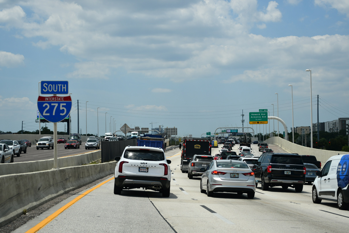
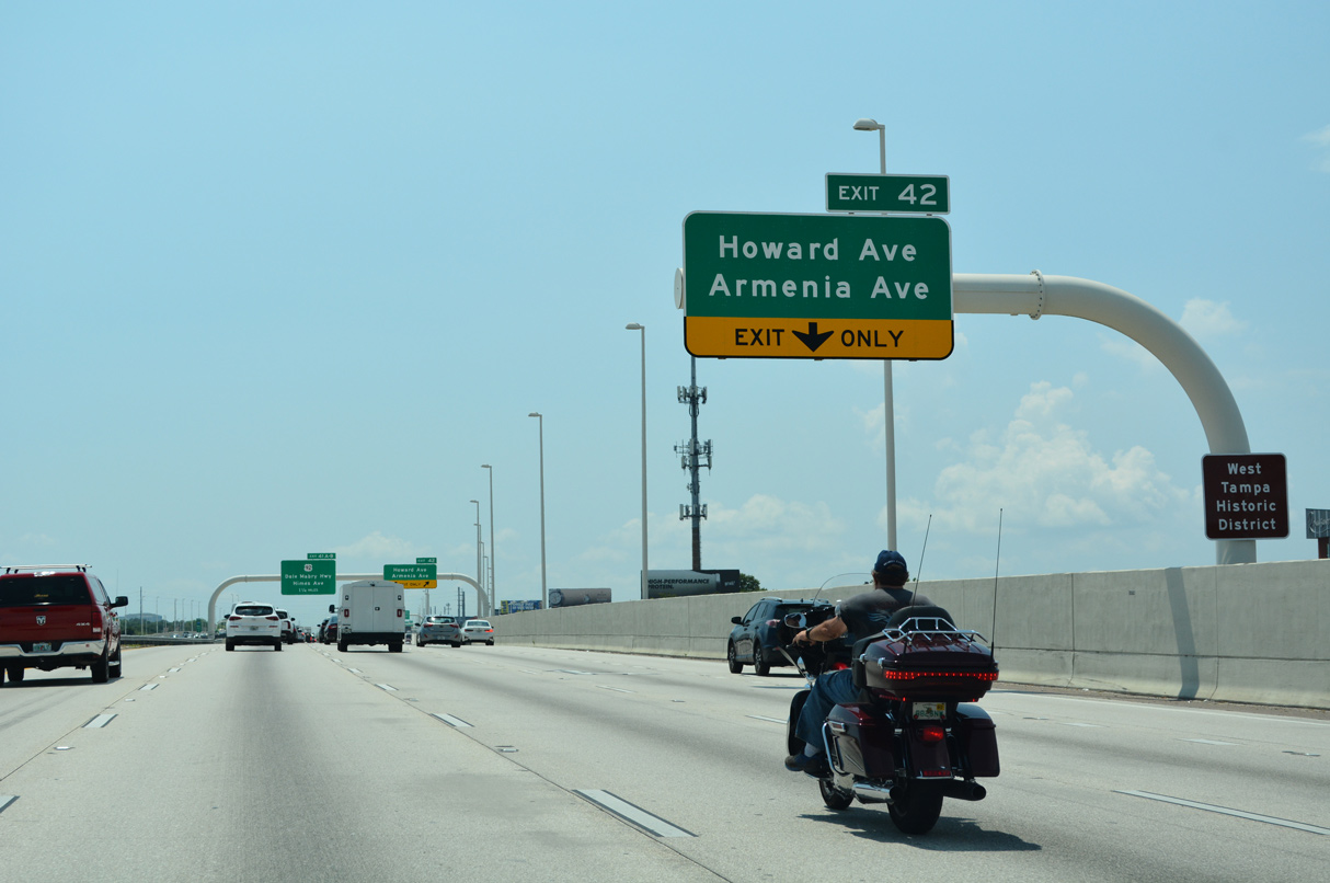
| Continuing west beyond Downtown, Interstate 275 advances to the West Riverfront and North Hyde Park neighborhoods. Exit 42 departs there for both Howard and Armenia Avenues.
A left side ramp was used during the multi-year widening of I-275 for Exit 42. It was switched to a right side exit in 2015. 04/25/16 |
|
| A lane drop occurs along southbound Interstate 275 at the Hillsborough River. 08/22/15 |
|
| An entrance ramp joins Interstate 275 west from Ashley Drive north at the Hillsborough River and this shield. 04/25/16 |
|
| Exit 42 consists of a split diamond interchange with Armenia Avenue south and Howard Avenue north, a one way couplet joining the West Tampa and Hyde Park communities. 03/04/16 |
|
| A dynamic message board precedes a ramp stub at the Willow Avenue overpass along I-275 southbound. A companion stub lines the northbound side. 02/18/17 |
|
| Armenia Avenue stretches all the way south from Carrollwood outside the city to Swann Avenue at Palma Ceia Pines. A portion of this route was former Florida Secondary 587A. 08/22/15 |
|
| A two lane ramp branches away from Interstate 275 south to join parallel Green Street ahead of Howard Avenue north and Armenia Avenue south.
Howard Avenue flows north from Bayshore Boulevard and Historic Hyde Park. 03/04/16 |
|
| Forthcoming Exit 41B provides the most direct route from Interstate 275 to Raymond James Stadium and George Steinbrenner Field. The venues line U.S. 92 (Dale Mabry Highway) north, 1.3 and 1.6 miles away from I-275 respectively. 03/04/16 |
|
| Pushing through West Tampa, Interstate 275 approaches the successive ramps for Himes Avenue (Exit 41B) and Dale Mabry Highway (Exit 41A). Dale Mabry Highway constitutes a crowded commuter route south to the gate of MacDill Air Force Base in South Tampa and north to Hillsborough Community College. 03/04/16 |
|
| A monotube supports a dynamic message board at the Green Street on-ramp from adjacent Armenia Avenue. 04/25/16 |
|
| I-275 crosses over MacDill Avenue by MacFarlane Park just ahead of Exit 41. 03/04/16 |
|
| Himes Avenue parallels U.S. 92 (Dale Mabry Highway) northward through the adjacent MacFarlane Park neighborhood to the Stadium Area. Southward both roads continue to Oakford Park and Bon Air. 03/04/16 |
|
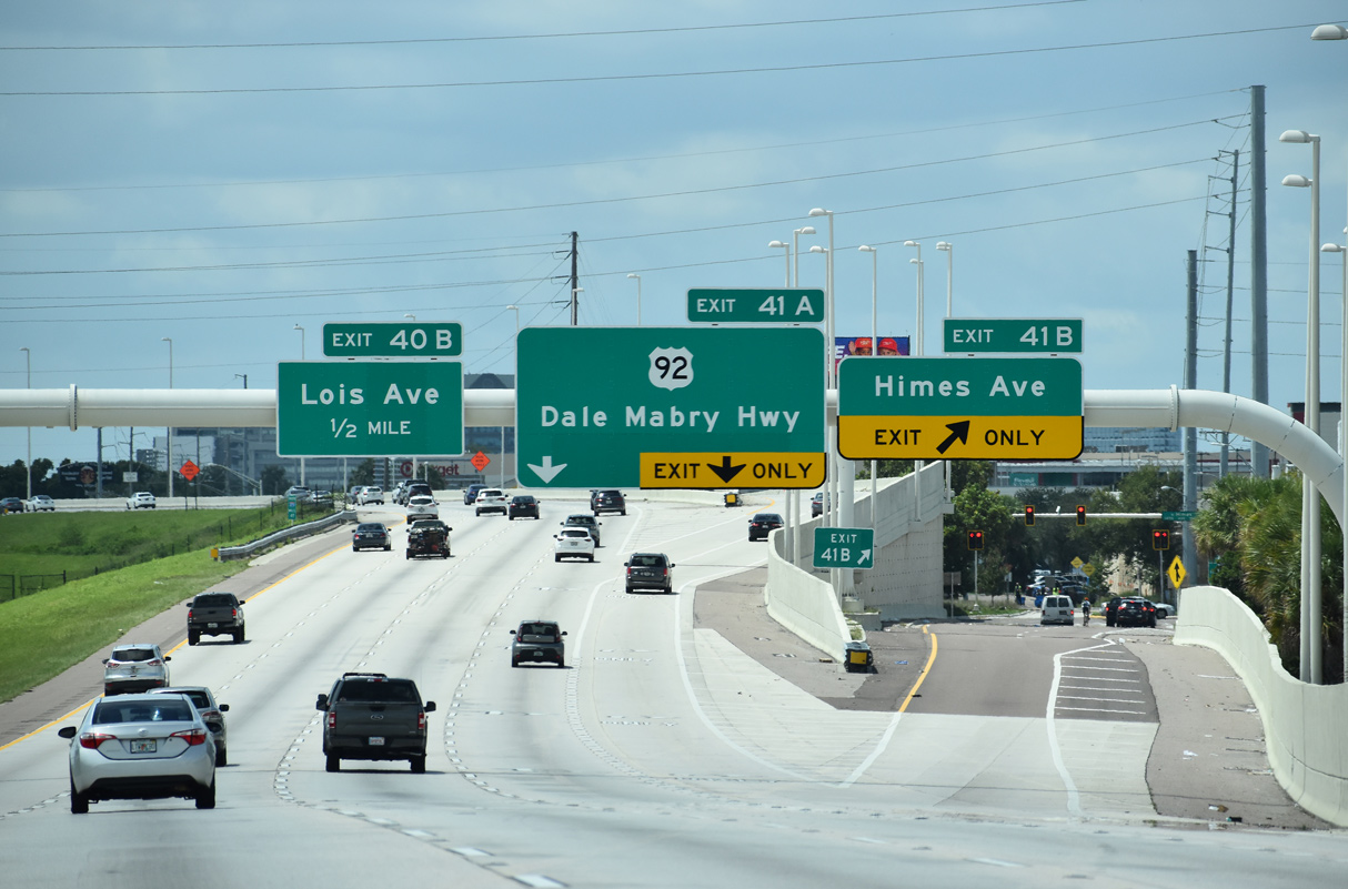
| Exit 41B departs Interstate 275 south for Himes Avenue. This ramp was previously numbered Exit 41C when two ramps served U.S. 92. 03/04/16 |
|
| U.S. 92 (Dale Mabry Highway) converges with Interstate 275 for the second time within Tampa at Exit 41A. 03/04/16 |
|
| The north-south leg of U.S. 92 follows Dale Mabry Highway from Hillsborough Avenue at Drew Park to Gandy Boulevard in South Tampa. U.S. 92 crosses the Gandy Bridge over Tampa Bay to the Gateway area of St. Petersburg. 04/21/18 |
|
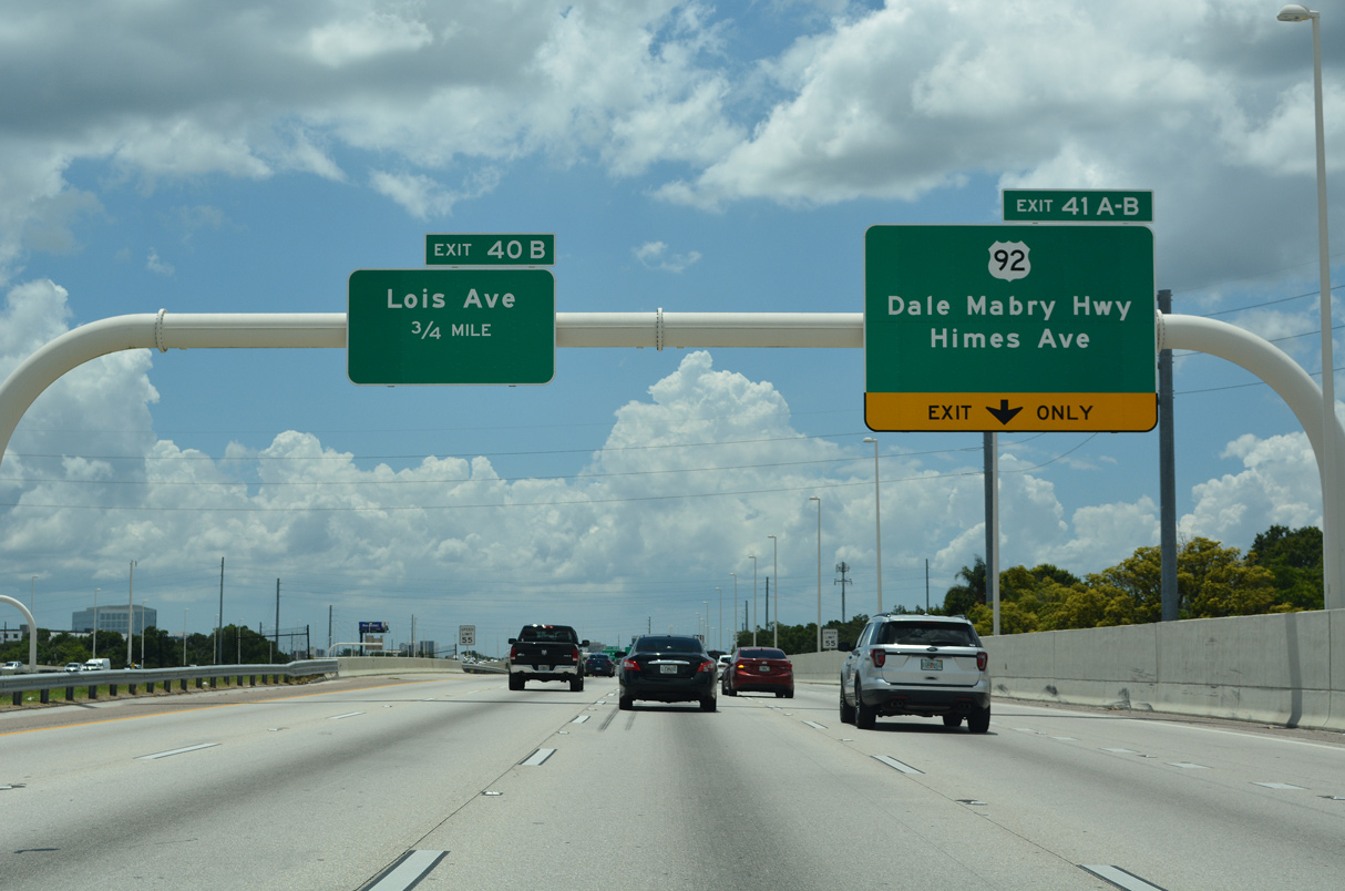
| Exit 40B leaves I-275 south next for Cypress Street east of Lois Avenue. Lois Avenue leads north to International Plaza mall through the Carver City / Lincoln Gardens community. 03/04/16 |
|
| A modified diamond interchange joins Interstate 275 with Lois Avenue north of the North Bon Air neighborhood. West Shore Boulevard (CR 587) follows via Exit 40A south through Westshore Palms and Beach Park.
Motorists bound for Pinellas County are advised of the forthcoming Howard Frankland Bridge. A seven mile exit less stretch ensues beyond the Memorial Interchange (Exit 39). 03/04/16 |
|
| An on-ramp joins I-275 south from Dale Mabry Highway one quarter mile ahead of the half diamond interchange (Exit 40A) with Westshore Boulevard. 03/04/16 |
|
| WestShore Plaza mall lies on the south side of I-275 between Westshore Boulevard and the Memorial Interchange at SR 60. SR 60 branches northward from Kennedy Boulevard by the mall onto a freeway leading to Tampa International Airport (TPA) and Courtney Campbell Causeway ahead of Rocky Point. 03/04/16 |
|
| Two lanes part ways with Interstate 275 south for West Shore Boulevard via Exit 40A. Westshore Boulevard doubles as County Road 587 south from SR 616 (Spruce Street) at International Plaza mall to Interbay Boulevard at Port Tampa City. The route is vastly unsigned. 04/25/16 |
|
| The Westshore Boulevard off-ramp passes over the Lois Avenue entrance ramp beside this shield assembly for I-275 south. This design eliminated a weaving traffic pattern between the closely spaced interchanges. 08/22/15 |
|
| SR 60 parallels Interstate 275 along Kennedy Boulevard, a heavily traveled commercial route, from Downtown to Westshore. The state road overtakes Memorial Highway northwest from Exit 39 toward TPA Airport, which replaced part of the original Memorial Highway to Dana Shores. No vestiges of the original roadway remain, as SR 60 comprises a wide freeway to the Veterans Expressway (SR 589). 03/06/19 |
|
| Two lanes separate at Exit 39 for SR 60 west to SR 589 north. SR 60 crosses Old Tampa Bay en route to Clearwater. The state road concludes a 161.34 mile cross peninsular route from Vero Beach at Clearwater Beach. 03/06/19 |
|
| Entering the Memorial Interchange (Exit 39) with SR 60 west on I-275 southbound. SR 589 north stems north from SR 60 along the tolled Veterans Expressway to Carrollwood, Citrus Park and Lutz among other Hillsborough County suburbs. The state road extends into Pasco County along the Suncoast Parkway, a 42 mile toll road between the Northdale area and U.S. 98 north of Brooksville in Hernando County. 03/06/19 |
|
| Interstate 275 narrows to four overall lanes through the Memorial Interchange. The I-275 Operational Improvements project from March 2019 to late 2020 adds an additional through lane in both directions between Lois Avenue and the Howard Frankland Bridge. 12/24/16 |
|
| Waters from Old Tampa Bay spread into view as I-275 angles west southwest toward the Pinellas County peninsula. A distance sign once stood at this location listing the distance to both St. Petersburg and Largo. 08/22/15 |
|
| With four lanes, the southbound Howard Frankland Bridge span opened in August 1991, doubling the capacity of the busy crossing between Tampa and St. Petersburg. Work underway from 2020 to late 2025 constructs a new bridge for southbound traffic and expands the crossing with two Express toll lanes per direction. 03/06/19 |
|
| Approaching the navigational channel hump along the Howard Frankland Bridge on Interstate 275 south. The southbound span will be converted for use for northbound traffic as a new eight lane bridge is built along the west side.1 08/22/15 |
|
| The Pinellas County line lies almost midway across the Howard Frankland Bridge. 08/22/15 |
08/30/14, 04/13/15, 04/22/15, 08/22/15, 09/05/15, 10/07/15, 12/14/15, 01/18/16, 03/04/16, 04/25/16, 12/24/16, 02/18/17, 04/13/18, 04/21/18, 03/06/19, 05/25/19, 11/21/19 by AARoads
Page Updated 03-02-2020.

 South
South