|
| LA 47 northbound shield assembly posted at Morales Street in Chalmette. The state highway comprises a five lane arterial northward to Virtue Street. 06/09/10 |
|
| Entering the intersection with Solidelle Street and the entrance to Park Plaza Shopping Center along Paris Road northbound. 06/09/10 |
|
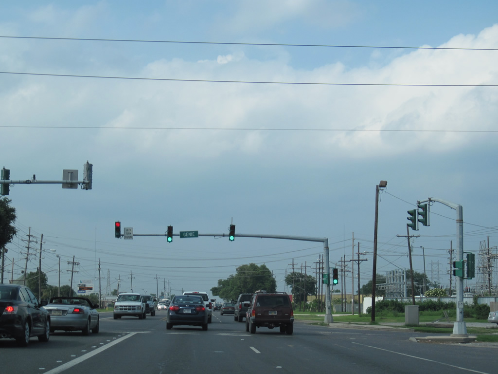
| Genie street provides the last through street connecting LA 47 with residential areas to the east of De La Ronde Canal in Chalmette. Westward, Genie Street becomes Patricia Street at Guichard Canal. 06/09/10 |
|
| LA 47 (Paris Road) leaves the Chalmette residential street grid behind at Virtue Street. Industrial frontage occasionally fronts the divided highway northward to the Intracoastal Waterway. 06/09/10 |
|
| Marina Road spurs east from a set of flashers at LA 47 as the Intracoastal Waterway bridge comes into view. 06/09/10 |
|
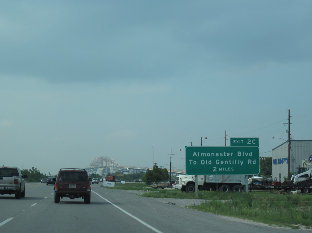
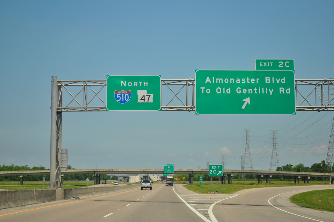
| The two mile guide sign for I-510 at Exit 2C/ Almonaster Boulevard appears along LA 47 (Paris Road) northbound just beyond the Saint Bernard Parish line (Bayou Bienvenue). 06/09/10 |
|
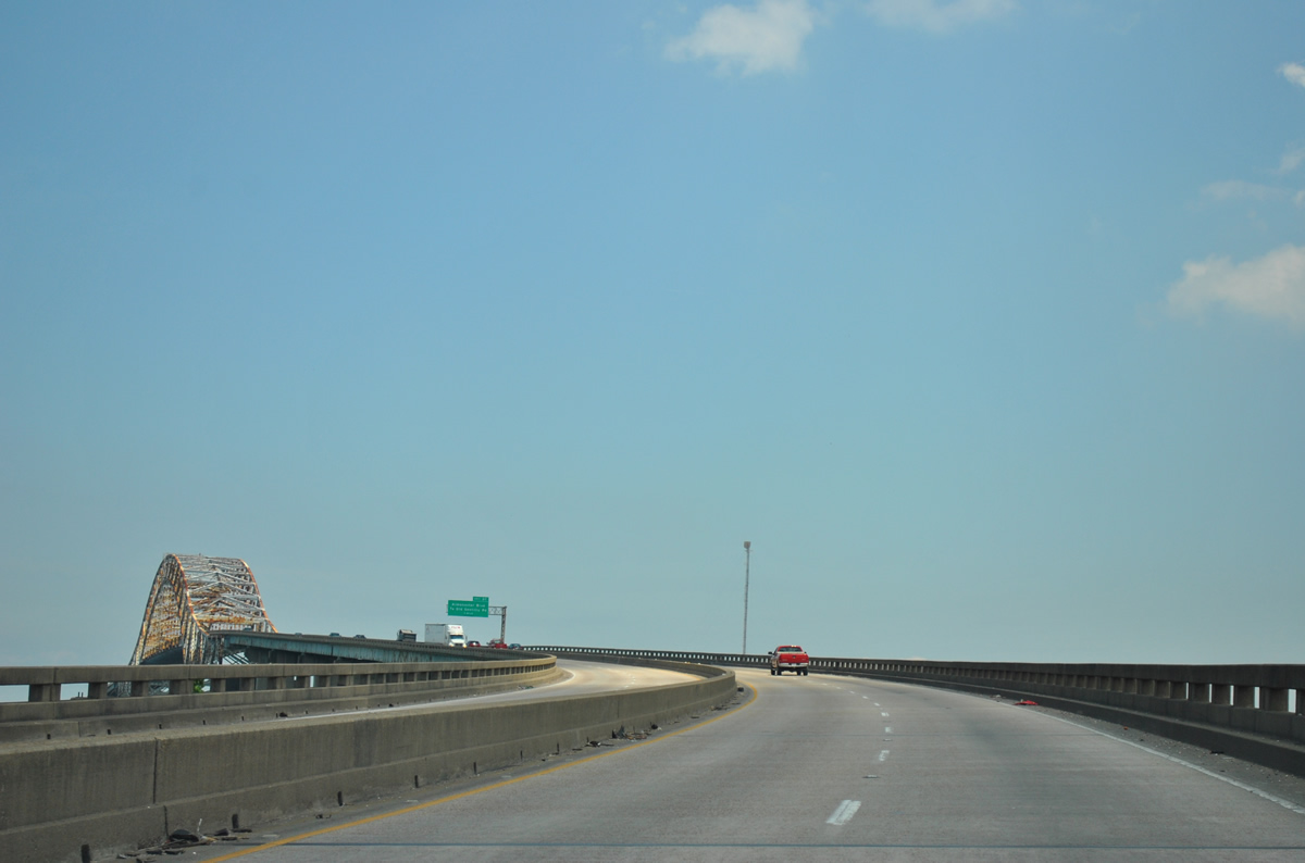
| LA 47 (Paris Road) northbound at the Intracoastal Waterway bridge. The steel arch bridge rises 135 feet above the Mississippi River Gulf Outlet Canal and can be seen from Interstate 10, five miles to the west. 06/10/06, 04/20/12 |
|
| LA 47 transitions into Interstate 510 at the north end of the Intracoastal Waterway Bridge. There a diamond interchange joins the freeway with Almonaster Boulevard between intersections with Old Gentilly Road. Almonaster Boulevard leads west to the New Orleans Business & Industrial District and Jourdan Road at I-10. 04/20/12 |
|
| Northbound LA 47 (Paris Road) at the crest of the Intracoastal Waterway Bridge. Built in 1967, the bridge travels 6,620 feet.1 04/20/12 |
|
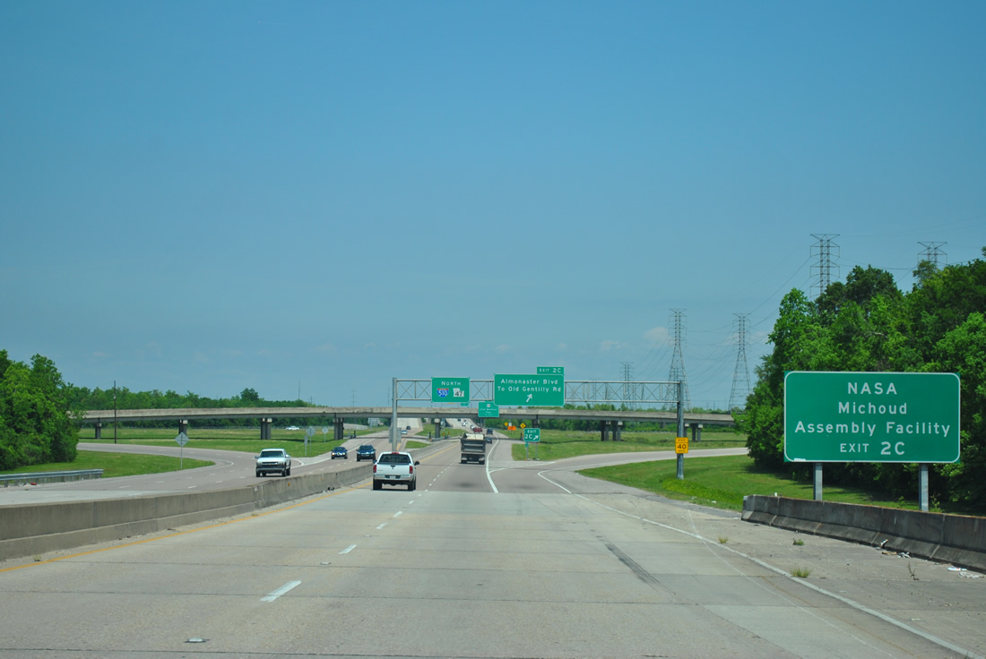
| The majority of the 3.04 mile long route of I-510 appears along the descent of LA 47 toward Exit 2C, just west of the Entergy Michoud Plant. 04/20/12 |
|
| Forthcoming Almonaster Boulevard becomes Old Gentilly Road east of I-510 en route to the Michoud section of New Orleans. The NASA Michoud Assembly Facility lies just east of the freeway at Michoud Boulevard and Old Gentilly Road. Old Gentilly Road combines with U.S. 90 (Chef Menteur Highway) further east. 04/20/12 |
|
| Interstate 510 begins as Exit 2C departs LA 47 for Almonaster Boulevard. Almonaster Boulevard and Old Gentilly Road travel west through the industrial areas of New Orleans East. Exit 2A serves the residential section of New Orleans East via U.S. 90 (Chef Menteur Highway) west. 04/20/12 |
|
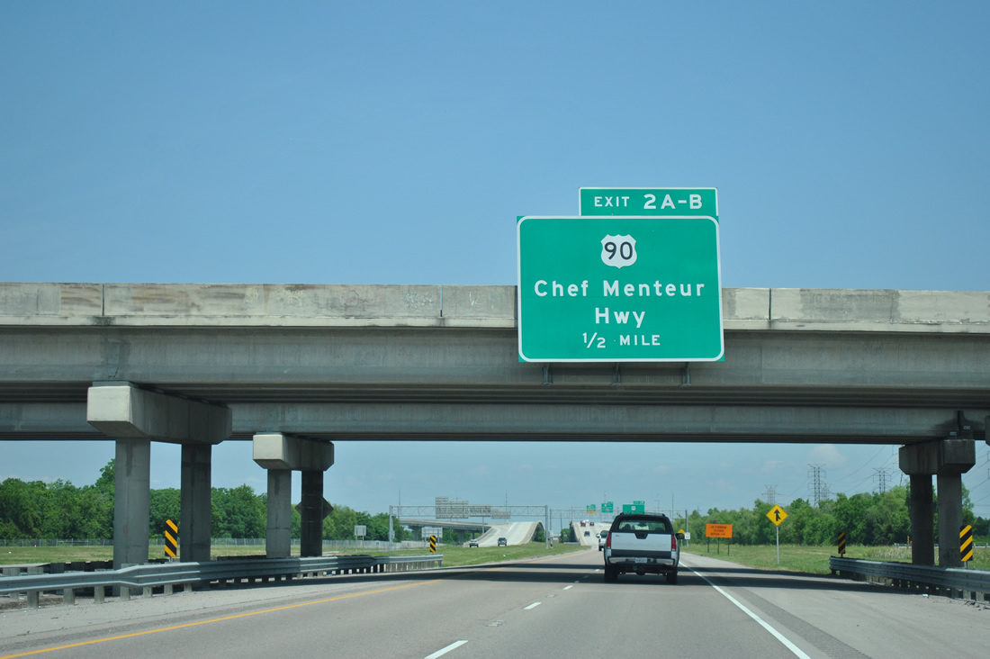
| I-510/LA 47 advance a half mile from the Almonaster Boulevard over crossing to a six-ramp parclo interchange (Exits 2 A-B) with U.S. 90 (Chef Menteur Highway). 04/20/12 |
|
| I-510/LA 47 northbound gains an auxiliary lane between Exit 2 C and Exit 2 B for U.S. 90 (Chef Menteur Highway) east. U.S. 90 passes through Michoud toward the junction with U.S. 11 and Venetian Isles. The freeway elevates over a CSX Railroad line ahead. 04/20/12 |
|
| Traffic to U.S. 90 (Chef Menteur Highway) eastbound departs I-510/LA 47 northbound. U.S. 90 meanders eastward from New Orleans to Bayou Sauvage National Wildlife Refuge en route to the Chef Menteur Pass and the Rigolets. Bridges along the route suffered damage during Hurricane Katrina but reopened by Winter of 2006. Flood waters from Hurricane Isaac in 2012 closed the bridges briefly as well. 04/20/12 |
|
| Westbound traffic to U.S. 90 (Chef Menteur Highway) leaves the northbound freeway via a loop ramp at Exit 2A. 04/20/12 |
|
| Northbound at the Exit 2A ramp departure to U.S. 90 (Chef Menteur Highway) west. U.S. 90 travels along the south side of New Orleans East's residential area between I-510 and Exit 240B of Interstate 10. 04/20/12 |
|
| A segment of Dwyer Road spans I-510/LA 47 to link the Paris Road (former LA 47) frontage road system. The previous guide sign for Lake Forest Boulevard (Exit 1B) here was replaced with a dynamic message board in 2008. 06/10/06 |
|
| Lake Forest Boulevard begins at Mayo Boulevard at Lake Forest to the west and ends at Michoud Boulevard nearby. 04/20/12 |
|
| Confirming markers for I-510 and LA 47 north preceding Exit 1B. 11/19/08 |
|
| A diamond interchange (Exit 1B) joins I-510/LA 47 with Lake Forest Boulevard. 04/20/12 |
|
| A Six Flags Theme Park guide sign remained in place for the Lake Forest Boulevard eastbound ramp from I-510 north. 04/20/12 |
|
| The abandoned Six Flags New Orleans (formerly Jazz Land) theme park lies just east of I-510/LA 47. Built in 2000, the park was bought by Six Flags in 2002 after financial troubles. While the structural integrity of the six roller coasters and other large scale rides remained fairly intact following the landfall of Hurricane Katrina, water damage to the electrical systems, sewer lines, and other low-lying structures was extreme. Before the hurricane struck, the facility was one of the Six Flag's least attended parks.2 06/10/06 |
|
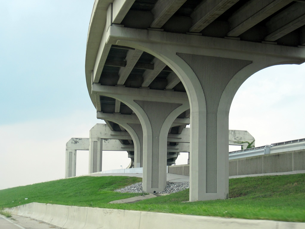
| Interstate 510/LA 47 travel a short viaduct between Lake Forest Boulevard and the multi level interchange (Exit 1A) with I-10. 04/20/12 |
|
| The lifeless "Mega Zeph" coaster crests at 110 feet to the east of Interstate 510 and Paris Road. Discussion continues in 2012 involving the development of the former theme park into a new outlet mall. Otherwise the derelict park was used as a set for the filming of the movie Percy Jackson: Sea of Monsters during summer 2012. 04/20/12 |
|
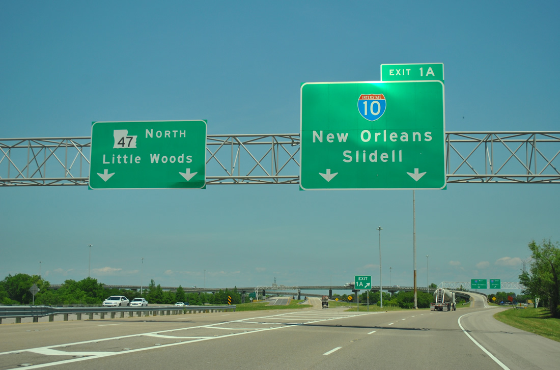
| All traffic to Interstate 10 from I-510/LA 47 northbound departs in unison at Exit 1A. Eastbound I-10 travels 15 miles northward through the Bayou Sauvage National Wildlife Refuge and across Lake Pontchartrain to the city of Slidell. 04/20/12 |
|
| Exit 1A partitions into ramps for Interstate 10 west and east. A flyover ramp shuttles traffic onto Interstate 10 west through New Orleans East to Downtown. 04/20/12 |
|
| Looking westward at Interstate 10 and New Orleans East from the flyover at Exit 1A. 06/10/06 |
|
| Interstate 510 north ends as LA 47 resumes along Paris Road north to Hayne Boulevard at Little Woods. 04/20/12 |
|
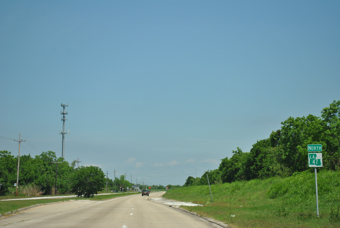
| LA 47 shield posted after I-10 Service Road. Paris Road continues as a four lane divided highway to Hayne Boulevard. 04/20/12 |
|
| LA 47 is an unsigned highway beyond Paris Road along Hayne Boulevard west. A levee obscures Lake Pontchartrain and a parallel Norfolk Southern Railroad line from view at this set of flashers. 06/09/10 |
|
| Hayne Boulevard parallels the southern periphery of Lake Pontchartrain from Paris Road west to the Senator Ted Hickey Bridge across the Inner Harbor Navigation Canal. The four lane arterial is undivided with a painted median in places. 06/09/10 |
|
| Bullard Avenue north at Hayne Boulevard (LA 47). The divided parkway travels one mile to a diamond interchange (Exit 245) with Interstate 10. 06/09/10 |
|
| Read Boulevard follows at the succeeding traffic light, joining Hayne Boulevard with I-10 at a commercialized diamond interchange (Exit 244). 06/09/10 |
|
| Crowder Boulevard leads south from Hayne Boulevard to Interstate 10 at Exit 243 and U.S. 90 (Chef Menteur Highway). 06/09/10 |
|
| A flyover ramp connects Hayne Boulevard westbound with Stars & Stripes Boulevard west ahead of New Orleans Lakefront Airport (NEW). 06/09/10 |
|
| Closed at the time of these photos, the flyover elevates to pass over the adjacent NS Railroad to join Stars & Stripes Boulevard westbound ahead of the Senator Ted Hickey Bridge across the Inner Harbor Navigation Canal. 06/09/10 |
|
| The flyover ramp from Hayne Boulevard onto Stars & Stripes Boulevard, and another elevated ramp further west, opened in 1998. 06/09/10 |
|
| Passing by Lamb Road, Hayne Boulevard (LA 47) partitions to accommodate the eastbound flyover ramp from the Senator Ted Hickey Bridge. 06/09/10 |
|
| A set of mast-arm supported signals alternates traffic flow between Hayne Boulevard east and the on-coming flyover ramp. 06/09/10 |
|
| Traveling below the rising flyover on Hayne Boulevard (LA 47) west. A u-turn lane provides local access to Hayne Boulevard east alongside the elevated ramp. 06/09/10 |
|
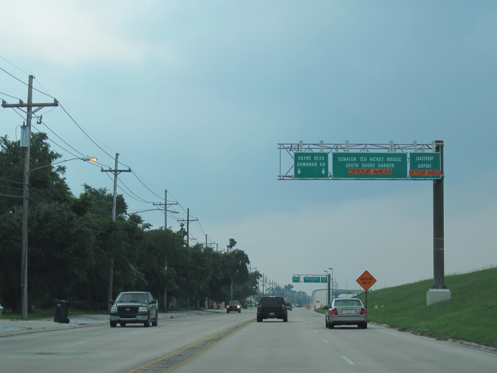
| Unmarked LA 47 concludes at the intersection of Hayne Boulevard and Downman Road. Downman Road leads south to Interstate 10 (Exit 240) and north to Stars and Stripes Boulevard at New Orleans Lakefront Airport (NEW). Hayne Boulevard ends at Jourdan Road ahead and is discontinuous west to Press Drive. 06/09/10 |
Page Updated 09-05-2012.

 North
North