Interstate 540 represents a 14.1 mile spur linking I-40 with Van Buren and Fort Smith. Originally signed as an east-west route, the 1960s-built freeway spur ended at AR 22 (Rogers Avenue) east of Downtown Fort Smith, but saw further extension southwest toward U.S. 271 and the Oklahoma border as AR 540. The final 2.6 mile stretch of State Highway 540 between U.S. 71 and the Oklahoma state line opened to traffic October 19, 1978 at a cost of $9.6 million.1 However, by 1980 this designation was replaced by Interstate 540 along the entire stretch. I-540 provides a connection between Van Buren and Fort Smith via a four-lane span across the Arkansas River. At a cost of $4.36 million, the high-level bridge was constructed in under two years (early 1965 to late 1966) with a dedication and opening held December 29, 1966.2
From January 8, 1999 to April 21, 2014, Interstate 540 also extended north from I-40 near Alma to the greater Fayetteville-Springdale-Bentonville metro area, creating an 80.72 mile spur. With the inclusion of Interstate 49 from Alma to Bentonville, the I-540 designation was truncated to its original Fort Smith spur.
All signage along I-540 in Van Buren and Fort Smith was replaced by late Spring 2014. This included all ground-based guide signs, overheads and shield assemblies.
|
| Crossing into Arkansas and Sebastian County from Oklahoma, U.S. 271 north prepares to depart ahead. Interstate 540 will begin its 14.1 mile stint to I-40 at the diamond interchange it shares with U.S. 271 and Arkansas 253 south (Exit 14). U.S. 271 continues another 2.54 miles north to its terminus at U.S. 71 Business. Arkansas 253 stems south 2.1 miles to Arkansas 45 and Enterprise. Use Exit 14 to reach both the Port of Fort Smith and Sparks Regional Medical Center. 05/06/12 |
|
| Jenny Lind Road (Exit 13) follows in 0.75 miles. The local road connects Interstate 540 to the Fianna Hills neighborhood. 05/06/12 |
|
| I-540/U.S. 71 north reaches the ramp to AR 45 (Old Greenwood Road) and Exit 10. Old Greenwood Road carries AR 45 south 3.7 miles to U.S. 71. The state highway sees an end immediately north of I-540 at Phoenix Avenue which runs west toward U.S. 71 Business (Towson Avenue) and east toward Fort Smith Regional Airport (FSM). 05/06/12 |
|
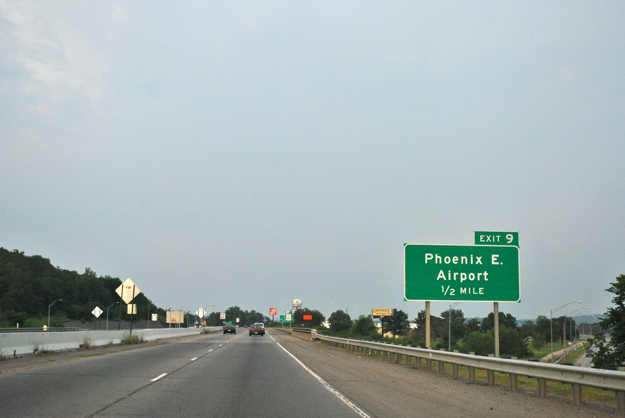
| The freeway passes over Phoenix Avenue on its one half mile approach to a connection with Fort Smith Regional Airport (Exit 9). 05/06/12 |
|
| U.S. 71 remains the unmarked counterpart for Interstate 540 as it curves northeast toward Exit 9. 05/06/12 |
|
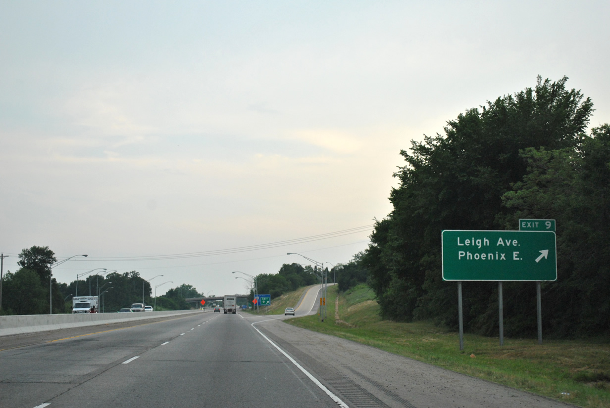
| Exit 9 provides a direct connection to Phoenix Avenue and to Airport Boulevard. Use Phoenix Avenue east from Interstate 540 north to reach the main terminal at FSM. Airport Boulevard leads to Ebbing Air National Guard Base. Leigh Avenue spans the freeway as the ramp leaves for Phoenix Avenue. 05/06/12 |
|
| Interstate 540 (U.S. 71) briefly parallels Phoenix Avenue before the local road turns east toward McKennon Boulevard and the freeway turns north toward AR 22 (Exit 8). 05/06/12 |
|
| Arkansas 22 travels along Rogers Avenue from Downtown Fort Smith southeast to Barling and Fort Chaffee. Overall the state highway traverses 75.6 miles between Fort Smith and Dardanelle. 05/06/12 |
|
| The freeway reaches the departure ramp to Arkansas 22 (Exit 8) at the Cliff Drive overpass. Arkansas 22 follows Rogers Avenue 3.7 miles northwest and will see an end at U.S. 71 Business (Towson Avenue) south of Downtown. Use State Highway 22 east to reach Fort Chaffee. 05/06/12 |
|
| Continuing north from Rogers Avenue and Exit 8, Interstate 540 will next encounter Grand Avenue (Exit 6) to Downtown Fort Smith. 05/06/12 |
|
| I-540/U.S. 71 north meets Grand Avenue at a diamond interchange (Exit 6) in 0.75 miles. Grand Avenue west provides main access to the University of Arkansas Fort Smith campus. 05/06/12 |
|
| Exit 6 leaves I-540 north for Grand Avenue west toward Downtown Fort Worth. 05/06/12 |
|
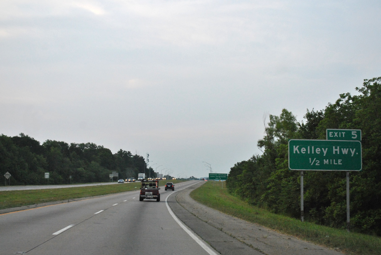
| Kelley Highway (Exit 5) will meet Interstate 540 next in one half mile. Use Kelley Highway west for access to the Arkansas-Oklahoma State Fairgrounds at Kay Rodgers Park. 05/06/12 |
|
| I-540 north reaches Exit 5 to Kelley Highway. The local road ends at the freeway but provides a connection to a single commercial center southeast of the interchange. Kay Rodgers Park lies along U.S. 71 Business and is reached via Kelley Highway west to 50th Street north. 05/06/12 |
|
| The freeway curves northeast in preparation of crossing over the Arkansas River into Van Buren. 05/06/12 |
|
| Two interchanges serve the city of Van Buren along I-540 north with the first one occurring in one mile at Arkansas 59 (Exit 3). The Port of Van Buren and Springhill Park are both accessed by Exit 3 ahead. 05/06/12 |
|
| Interstate 540 & U.S. 71 north spans the Arkansas River into Van Buren and Crawford County ahead of Exit 3 to Arkansas 59. The 3,396 foot bridge was constructed in 1965-1966. 05/06/12 |
|
| A departure ramp leaves Interstate 540 to Arkansas 59 at the foot of the bridge over the Arkansas River. Twin Circle Drive serves as the connection between the freeway and state highway. Arkansas 59 runs northwest toward Downtown Van Buren and southeast toward Springhill Park. Overall the highway travels 93.2 miles between Arkansas 22 at Fort Chaffee to Missouri 59 west of Bella Vista. 05/06/12 |
|
| Both I-540 & U.S. 71 prepares to cross under South 28th Street as it progresses northeast from Exit 3 through east Van Buren. 05/06/12 |
|
| One mile guide sign for U.S. 64 (Exit 2) to Van Buren. The U.S. highway enters Arkansas at Fort Smith and follows U.S. 71 Business northeast through Van Buren to the approaching cloverleaf interchange. 05/06/12 |
|
| U.S. 64 east (Exit 2B) closely parallels Interstate 40 to Ozark where the highway dips southeast to Altus and Coal Hill. U.S. 64 west to Van Buren leaves in one-quarter mile while Interstate 540 will meet its parent in 0.5 miles. 05/06/12 |
|
| A loop ramp directs travelers from Interstate 540 & U.S. 71 north to U.S. 64 west (Exit 2A). Though not signed here, U.S. 71 Business also runs concurrent with U.S. 64 west to both Van Buren and Fort Smith. Interstate 40 connects the Fort Smith-Van Buren area with Oklahoma City to the west and the Arkansas capital city of Little Rock to the east. U.S. 71 will follow I-40 east to Exit 13 where it continues north toward the Fayetteville-Springdale-Bentonville metro area. 05/06/12 |
|
| Interstate 540 officially ends at trumpet interchange with Interstate 40 (Exits 1B-A). Prior to April 21, 2014 the designation extended an additional 66.6 miles along the John Paul Hammerschmidt Highway to Fayetteville but was truncated to its original Fort Smith alignment in favor for Interstate 49. I-40 east carried I-540 north to Exit 12 to make the connection but with the I-49 designation taking over the Fayetteville-Bentonville freeway, I-540 was removed. Little Rock lies 151 miles to the southeast via Interstate 40 east to Interstate 30 west. Use Exit 1B for northbound U.S. 71 traffic and Exit 1A for I-40 west to Oklahoma City 189 miles away. 05/06/12 |
|
| Interstate 540 & unsigned U.S. 71 quickly encounters the cloverleaf interchange to U.S. 64 south of its beginning at nearby Interstate 40. Exit 2A will carry traffic to U.S. 64 west to Van Buren while a loop ramp will leave for U.S. 64 to Alma (Exit 2B) in 0.25 miles. Not signed, U.S. 71 Business also departs at Exit 2A for Van Buren and Downtown Fort Smith and returns to the freeway at Exit 12. Use U.S. 64 west and U.S. 71 Business south to reach Summit Medical Center in Van Buren. 05/06/12 |
|
| U.S. 64 east (Exit 2B) parallels Interstate 40 to the south en route to Alma, Dyer and Mulberry. The U.S. highway will meet its freeway counterpart in Clarksville. 05/06/12 |
|
| Arkansas 59 will meet the freeway in three-quarters of a mile ahead of the Arkansas River crossing. The state highway provides one final connection between I-540 and Van Buren. 05/06/12 |
|
| Interstate 540 reaches the departure ramp for Exit 3. Arkansas 59 travels over 93 miles from Arkansas 22 near Fort Chaffee to Missouri 59 west of Bella Vista. Use Riggs Drive to make the connection to Arkansas 59 (4th Street). 05/06/12 |
|
| The freeway prepares to cross over Arkansas 59 and the Arkansas River into Sebastian County and Fort Smith via a 1966-built span. 05/06/12 |
|
| The four lane bridge carrying Interstate 540 & U.S. 71 over the Arkansas River was constructed in 1965 and most of 1966, opening to traffic three days shy of January 1967. 05/06/12 |
|
| I-540 south approaches the first of nine interchanges serving Fort Smith in one mile at Kelley Highway (Exit 5). 05/06/12 |
|
| Kelley Highway provides a link between the freeway and the Arkansas-Oklahoma State Fairgrounds at Kay Rodgers Park. Otherwise the local arterial connects with U.S. 64 & U.S. 71 Business north of Downtown Fort Smith. 05/06/12 |
|
| Though not signed, U.S. 71 continues to follow Interstate 540 south from Kelley Highway (Exit 5) through the east side of Fort Smith. The duo will meet Grand Avenue next. 05/06/12 |
|
| Grand Avenue (Exit 6) directly links Interstate 540 with Downtown Fort Smith and the University of Arkansas Fort Smith campus in 0.75 miles. 05/06/12 |
|
| Interstate 540 & U.S. 71 south reach the diamond interchange with Grand Avenue. Use Grand Avenue west to reach both the college campus and Downtown. 05/06/12 |
|
| The freeway spans Free Ferry Road on the one mile approach to Arkansas 22 (Rogers Avenue). The state highway provides access to both the Fort Smith Regional Airport (FSM) and nearby Fort Chaffee. Overall Arkansas 22 travels 75.6 miles connecting Fort Smith with Dardanelle. 05/06/12 |
|
| Arkansas 22 west (Exit 8A) travels northwest from Interstate 540 toward Central Mall and Downtown while a loop ramp to Arkansas 22 east (Exit 8B) departs next. When I-540 was originally constructed in the 1960s it ended at this interchange with Arkansas 22, but by 1971 was extended further south and west to U.S. 71 as Arkansas 540. 05/06/12 |
|
| Exit 8B takes motorists to Arkansas 22 east (Rogers Avenue) toward Barling and Fort Chaffee. Use State Highway 22 east to South 74th Street to reach Fort Smith Regional Airport. 05/06/12 |
|
| Interstate 540 south crosses over Boston Street as it curves southwest to run parallel with Phoenix Avenue. 05/06/12 |
|
| A half diamond interchange connects Interstate 540 & U.S. 71 with Leigh Avenue (Exit 9) in one half mile. 05/06/12 |
|
| The freeway reaches the departure ramp for Exit 9 and Leigh Avenue. Leigh Avenue east provides a link with nearby Phoenix Avenue and Airport Drive. 05/06/12 |
|
| Leigh Avenue soars over Interstate 540 on the quarter mile approach to Arkansas 45 (Old Greenwood Road) and a second access to Phoenix Avenue. 05/06/12 |
|
| Arkansas 45 heads south from I-540 along Old Greenwood Road for 3.7 miles to U.S. 71 where it shares a brief overlap before continuing west and south to Bonanza. Phoenix Avenue west (Exit 10) provides the necessary connection to Arkansas 45 south. 05/06/12 |
|
| Interstate 540 & U.S. 71 passes under Arkansas 45 as the freeway curves south once more toward Arkansas 255 (Exit 11) in 0.75 miles. 05/06/12 |
|
| Arkansas 255 (Zero Street) meets Interstate 540 at a diamond interchange (Exit 11) in south Fort Smith. Overall the state highway exists in two segments within Sebastian County connecting Fort Smith with Barling and also connecting Central City with Lavaca. Its longest segment (17.2 miles) takes Arkansas 255 west from Barling to Wheeler Avenue in Fort Smith, turning north along Wheeler Avenue north to Downtown. 05/06/12 |
|
| U.S. 71 south leaves Interstate 540 at Exit 12 for Texarkana in the southwest corner of the state. The Texas-Arkansas border city lies 175 miles to the south at the crossroads of Interstates 30 & 49. Not signed along I-540, U.S. 71 Business also sees its return to U.S. 71 at Exit 12. 05/06/12 |
|
| 0.75 miles separate U.S. 71 (Exit 12) from Jenny Lind Road (Exit 13) along Interstate 540 south. 05/06/12 |
|
| South 28th Street passes over Interstate 540 on the approach to Jenny Lind Road (Exit 13). 05/06/12 |
|
| Motorists depart for Jenny Lind Road. The local road provides access between Interstate 540 and the nearby Fianna Hills neighborhood. 05/06/12 |
|
| The end of Interstate 540 occurs in 0.75 miles at the forthcoming interchange with U.S. 271 and Arkansas 253 (Exit 14). 05/06/12 |
|
| One last reassurance shield for Interstate 540 stands alongside the freeway on its final approach to U.S. 271. 05/06/12 |
|
| Interstate 540 quietly comes to an end at the diamond interchange with U.S. 271 and Arkansas 253 (Exit 14). U.S. 271 north travels another 2.54 miles from the interchange to its official end at U.S. 71 Business while Arkansas 253 continues south 2.1 miles to Arkansas 45 in Enterprise. U.S. 271 south joins the freeway and enters Oklahoma 0.65 miles to the west. 05/06/12 |
Sources:
- Arkansas Highways, Winter 1978, Volume 25, No. 1, Arkansas Department of Transportation (ARDOT).
- Arkansas Highways, January 1967, Volume 15, No. 1, Arkansas Department of Transportation (ARDOT).
05/06/12 by AARoads
Connect with:
U.S. 271
Page Updated 06-30-2014.

 North
North

 North
North