|
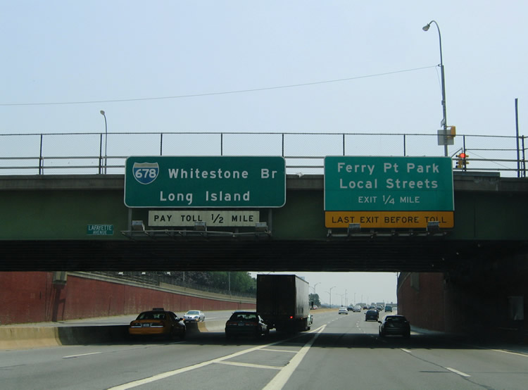
| Interstate 678 begins at the Bruckner Interchange with Interstate 95, 278, 295, and the Hutchinson River Parkway. The freeway continues the Hutch southward to Ferry Point Park and the Bronx Whitestone Bridge. Pictured here is the Lafayette Avenue over crossing and original 0.25 mile guide sign for Exit 18 (Schley Avenue).
Sign replacements increase the toll booth approach to 3/4 mile and replace "Local Streets" with Lafayette Avenue with the addition of an Exit 18 tab. 06/26/05 |
|
| Interstate 678 entails the southern most portion of the Hutchinson River Expressway between the Cross Bronx Expressway and Bronx Whitestone Bridge. The parkway was upgraded to expressway standards to accommodate Interstate 678. A frontage road system accompanies the freeway from the Bruckner Interchange southward to Ferry Point State Park. Slip ramps join the two roadways at the Exit 18 interchange near the Throgs Neck community of the east Bronx. 06/26/05 |
|
| Exit 18 represents the last departure point for Interstate 678 southbound travelers ahead of the Bronx Whitestone Bridge toll plaza. The slip ramp joins the southbound frontage street ahead of Ferry Point Park and Schley Avenue west to Brush Avenue.
A new sign bridge replaced this set of button copy overheads by 2011. Long Island was replaced with Queens as the southbound control city for Interstate 678. 06/26/05 |
|
| The Bronx Whitestone Bridge toll barrier resides within Ferry Point State Park ahead of the East River suspension bridge. Tolls are collected in either direction of travel at rates varying between E-ZPass/Cash transactions and Peak/Off-Peak Hours. December 30, 2010 toll increases upped the cash rate for passenger cars to $6.50. 06/26/05 |
|
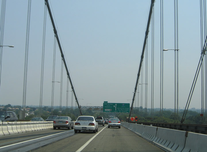
| Ascending over the East River via the Bronx Whitestone suspension Bridge. The Bronx Whitestone Bridge was first conceptualized by New York City transportation planner Robert Moses in the 1930s. The span would alleviate the Triborough Bridge to the west and provide a new route between the Bronx and Queens near a planned airport (La Guardia Airport) and the 1939-40 World's Fair site at Flushing. The New York State Legislature authorized construction of the span in 1937. The span opened after only 23 months of construction on April 29, 1939 at a cost of $19.7 million.1 06/26/05 |
|
| The one mile guide sign for Exit 17 was posted at the north tower of the Bronx-Whitestone Bridge; this sign was replaced with an advance sign for the Interstate 678 / Cross Island Parkway split by 2011.
The bridge tower rises to a height of 377 feet above the East River.1 06/26/05 |
|
| The Bronx-Whitestone Bridge carried four travel lanes with two pedestrian walkways after it first opened to traffic in 1939. Construction of the span was funded by tolls collected by the Triborough Bridge Authority. A 25 cent fee was levied onto all passenger vehicles initially. Interstate 678 was applied to the span by February of 1959 after initial proposals for Interstate 595 and 695 were rejected. Upgrading of the Hutchinson River Parkway between the bridge and Bruckner Interchange coincided with the allowing of trucks and buses on the newly signed Interstate highway.1 06/26/05 |
|
| Exit 17 leaves I-678 south in one half mile for 14th Avenue at the south tower of the Bronx-Whitestone Bridge. 14th Avenue travels east-west between College Point and Whitestone in north Queens. 06/26/05 |
|
| Descending toward Francis Lewis Park and the Whitestone community of north Queens on the Bronx-Whitestone Bridge. The bridge spans the East River with a total bridge length of 7,140 feet.1 06/26/05 |
|
| A diagrammatic overhead prepares motorists for the split of the Whitestone Expressway south from the Cross Island Parkway east at Exit 16. The Cross Island Parkway constitutes a major route between both the Bronx-Whitestone and Throgs Neck Bridges and Long Island. The parkway is part of the New York City Belt Parkway system.
An incident on March 27, 2009 involved an MTA boom truck striking this sign bridge, causing it to collapse over the traffic mainline. Two were injured in the crash and the bridge was closed for several hours leading into peak hours of that Friday afternoon.2 A new structure was later installed. 06/26/05 |
|
| Interstate 678 touches down and enters a directional interchange with the Cross Island Parkway (Exit 16). The Cross Island Parkway ventures east to Beechhurst, Bayside, and eastern Queens to provide connections to Interstate 495 (Long Island Expressway), Grand Central Parkway, and Southern State Parkway for eastern Long Island. 06/26/05 |
|
| Almost forgotten is the Exit 17 slip ramp onto the adjacent frontage street ahead of its intersection with 14th Avenue. Exit 17 also provides access to Parsons Boulevard north for the Malba neighborhood along Powell Cove. 06/26/05 |
|
| Cross Island Parkway departs Interstate 678 (Whitestone Expressway) southbound at Exit 16. Cross Island Parkway meets Interstate 295 (Throgs Neck Expressway) in 1.6 miles, Interstate 495 (Long Island Expressway) in 5.6 miles, and Grand Central Parkway in 6.3 miles. Interstate 678 meanwhile turns southwest toward Flushing, La Guardia Airport, and Corona Park. 06/26/05 |
|
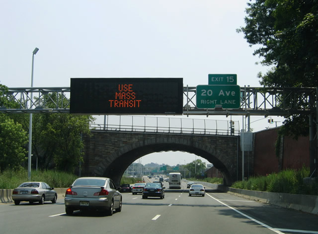
| Interstate 678 (Whitestone Expressway) leaves the Cross Island Parkway interchange and passes underneath 14th Avenue ahead of the Exit 15 ramp departure to 20th Avenue. 20th Avenue travels east-west between College Point, the abandoned Flushing Airport, and Auburndale in north Queens.
A Clearview font-based sign replaced the Exit 15 overhead by 2011. 06/26/05 |
|
| The Exit 15 diamond interchange utilizes the parallel Whitestone Expressway frontage streets within the vicinity of its intersection with 20th Avenue. 20th Avenue travels between Flushing Bay and Utopia Parkway near Clearview Park. 06/26/05 |
|
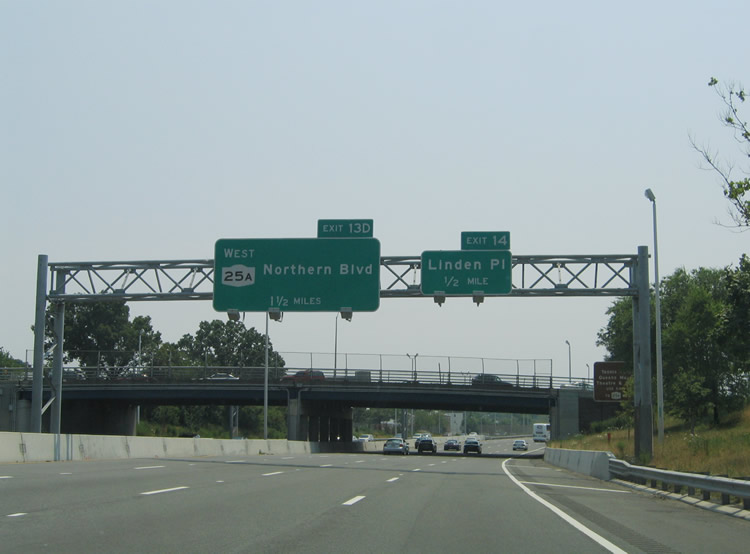
| The next southbound off-ramp joins Interstate 678 with Linden Place near the Flushing community of Queens. Linden Place continues 28th Avenue southeast to NY 25A (Northern Boulevard). 06/26/05 |
|
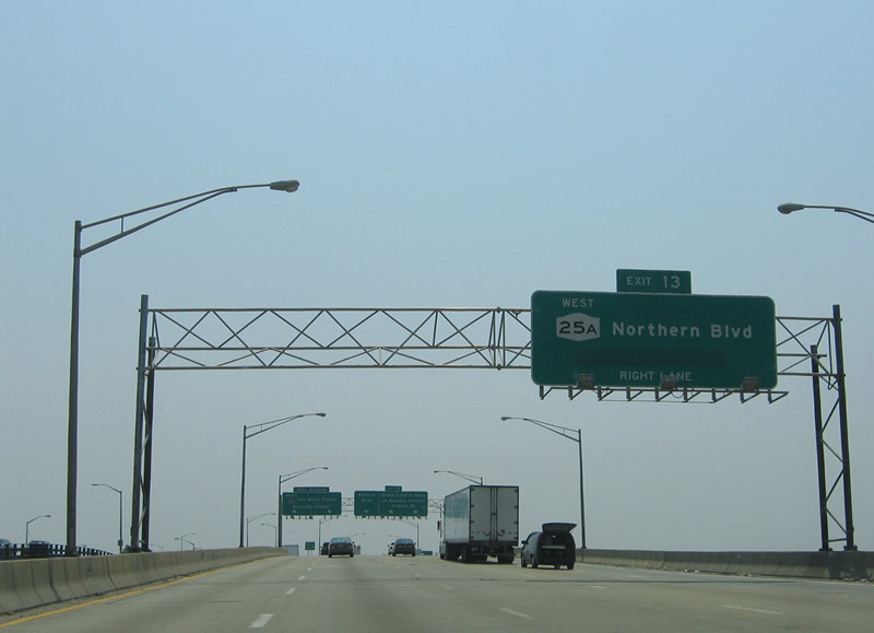
| Tourists destined for the USTA National Tennis Center, Queens Museum of Art, and Marina should use Exit 13 (NY 25A west - Northern Boulevard). Northern Boulevard skims the south shore of Flushing Bay between Interstate 678 (Van Wyck Expressway) and Grand Central Parkway at Citi Field. 06/26/05 |
|
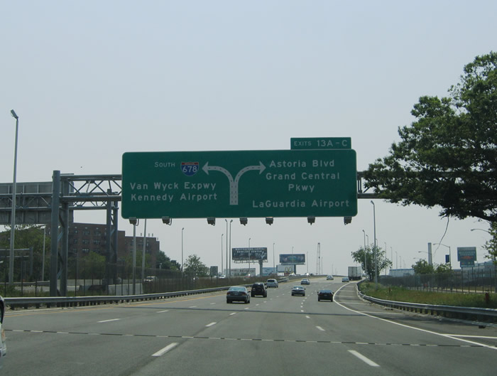
| Exit 13 represents a major split of traffic between Interstate 678 (Van Wyck Expressway) southbound and the Grand Central Parkway via NY 25A (Northern Boulevard) west. Large diagrammatic overheads partition traffic into two lanes for each freeway. 06/26/05 |
|
| Exit 14 departs Interstate 678 (Whitestone Expressway) onto the adjacent frontage street for Linden Place. Linden Place travels south to NY 25A and Flushing; 28th Avenue heads west to Ulmer Street and College Point. Other signs pictured here indicate connections to the Triborough (Robert F. Kennedy) Bridge and Flushing Marina (Exit 13D). Trucks bound for the Triborough (RFK) Bridge must use Astoria Boulevard through East Elmhurst in lieu of the Grand Central Parkway. 06/26/05 |
|
| Northern Boulevard enters the Exit 13 interchange as a surface boulevard from Flushing to the east. A freeway links Interstate 678 (Whitestone Expressway / Van Wyck Expressway) with the Grand Central Parkway at its interchange with Astoria and Northern Boulevards. Grand Central Parkway travels through East Elmhurst to La Guardia Airport and the merge with Interstate 278 (Brooklyn-Queens Expressway). The parkway heads south from Astoria Avenue parallel to Flushing Meadows - Corona Park to Kew Gardens. 06/26/05 |
|
| Interstate 678 transitions from the Whitestone Expressway to the Van Wyck Expressway at the Northern Boulevard interchange (Exit 13). The right lanes segregate into ramps for Astoria Boulevard west from those to the Grand Central Parkway. Traffic interests to Citi Field, home of MLB's New York Mets, should remain on Interstate 678 south.
New sign bridges replaced all signage along the Flushing Creek viaduct of Interstate 678 south by 2011. 06/26/05 |
|
| Exit 13 includes a direct ramp onto NY 25A (Northern Boulevard) westbound for Jackson Heights. NY 25A constitutes a touring route through Queens and Brooklyn, ending at the Queensboro Bridge approach of NY 25 (Queens Boulevard). 06/26/05 |
|
| Southbound at the ramp split of Exits 13ABC from Interstate 678 at the Van Wyck Expressway southbound beginning. There is no access onto Northern Boulevard eastbound for Flushing; travelers should use Exit 14 onto Linden Place south for NY 25A east. Grand Central Parkway east and Interstate 678 south cross paths in 3.5 miles. 06/26/05 |
Page Updated 02-16-2012.


 South
South