|
| A short distance east of the St. Joseph County line is the George N. Craig Travel Plaza east of the Edwardsburg Road overpass. The opposite service area along westbound is named the Henry F. Schricker Travel Plaza. 11/04/11 |
|
| SR 19 (Cassopolis Street) crosses paths with the Indiana Toll Road at the first of four Elkhart County interchanges. The state road comprises a commercial arterial north to Simonton Lake and south to Bristol Street in Elkhart. 11/04/11 |
|
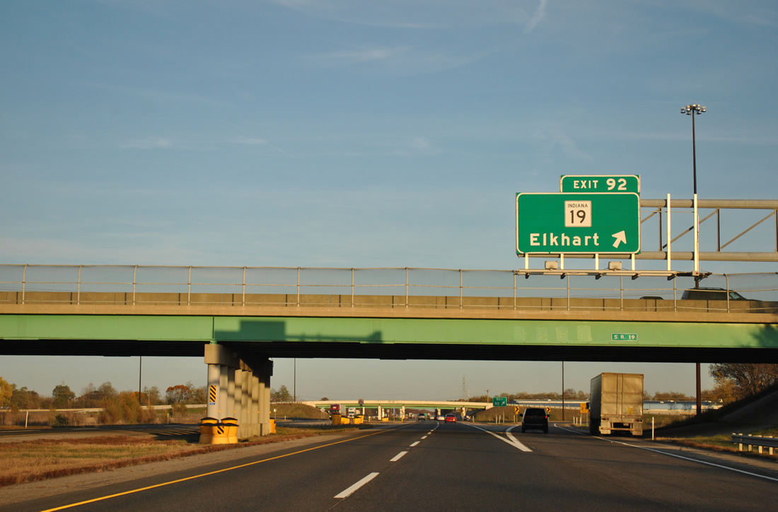
| Lowering from a crossing of Christiana Creek on the half mile approach to the trumpet interchange (Exit 92) and access road to SR 19. SR 19 consists of a 143 mile route north to the Michigan state line, two miles to the north of Exit 92, and south to Elkhart, Peru and Noblesville. 11/04/11 |
|
| Exit 92 leaves I-80/90 east for SR 19. SR 19 follows Cassopolis Street south to Bristol Street west (former SR 112) and Nappanee Street south to bypass downtown Elkhart. Old SR 19 continues into downtown via Main Street and a one way couplet of 2nd and 3rd Streets.
Northward Cassopolis Road links SR 19 with U.S. 12 at Pullman Corners. A portion of the route in Michigan was M-205, a route decommissioned in 2002. 11/04/11 |
|
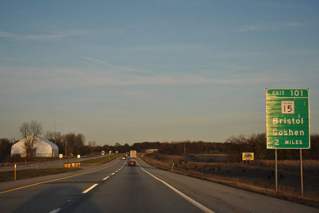
| Bristol and Goshen represent the destinations of SR 15 via Exit 101. Toledo follows in 134 miles. 11/04/11 |
|
| A number of industrial parks line the south side of the Indiana Toll Road along adjacent Elkhart County 6. 11/04/11 |
|
| One mile west of the Elkhart East interchange (Exit 96) near Heaton Lake on I-80/90 east. Exit 96 opened to traffic in 1997 to join the toll road with Elkhart County 17. 11/04/11 |
|
| County Road 17 leads north to become M-217 (Michiana Parkway), a 2002-constructed route linking I-80/90 with U.S. 12 near Union, Michigan. 11/04/11 |
|
| Exit 96 eastbound at the trumpet interchange and access road to County Road 17. CR-17 continues south from I-80/90 to the east end of St. Joseph Parkway, a freeway bypass for U.S. 20 on the south side of Elkhart, Mishawaka and South Bend. 11/04/11 |
|
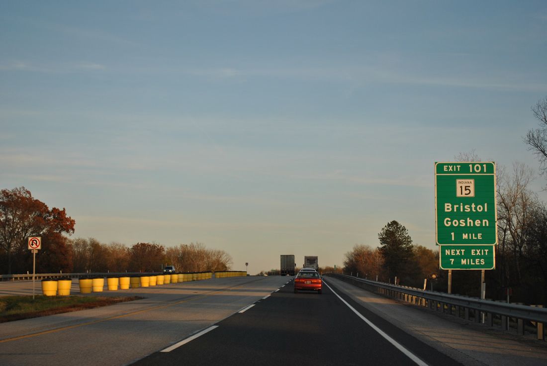
| A seemingly temporary style distance sign posted after the 1997-opened Exit 96 lists the distances to Bristol (5 miles), Goshen (15 miles) and Toledo (128 miles). 11/04/11 |
|
| County Road 19 passes over I-80/90 beyond the next shield and speed limit combination sign assembly. 11/04/11 |
|
| SR 15 angles northeast from Bristol along Mottville Road to meet I-80/90 via an access road north from the Exit 101 trumpet interchange. 11/04/11 |
|
| The St. Joseph River flows below I-80/90 again on the one mile approach to Exit 101 with SR 15. A 95 mile route, SR 15 ends nearby as M-103 and travels south from Bristol 9.7 miles to Goshen and ultimately to Gas City. 11/04/11 |
|
| Eastbound I-80/90 at Exit 101 to SR 15 (Mottville Road). M-103 extends 3.1 miles north from the state road to Mottville and U.S. 12. 11/04/11 |
|
| I-80/90 loop southward to span a Norfolk Southern Railroad line from SR 15. 11/04/11 |
|
| Interstate 69 appears for the first time at 42 miles west of the final Indiana interchange. Middlebury is the last Elkhart exit. 11/04/11 |
|
| SR 13 north and U.S. 131 south come together at the access road leading east from the Exit 107 trumpet interchange of I-80/90 in two miles. 11/04/11 |
|
| SR 13 travels 138 miles south from the Indiana Toll Road to Fortville and U.S. 36. U.S. 131 crosses the Michigan state line in 0.7 miles and travels 271 miles overall to Petoskey, Michigan. 11/04/11 |
|
| Exit 107 departs the eastbound toll road for SR 13 south and U.S. 131 north. U.S. 131 travels to White Pigeon (U.S. 12, a former terminus of the route), Constantine, and Three Rivers, Michigan. SR 13 continues south five miles to Middlebury. 11/04/11 |
|
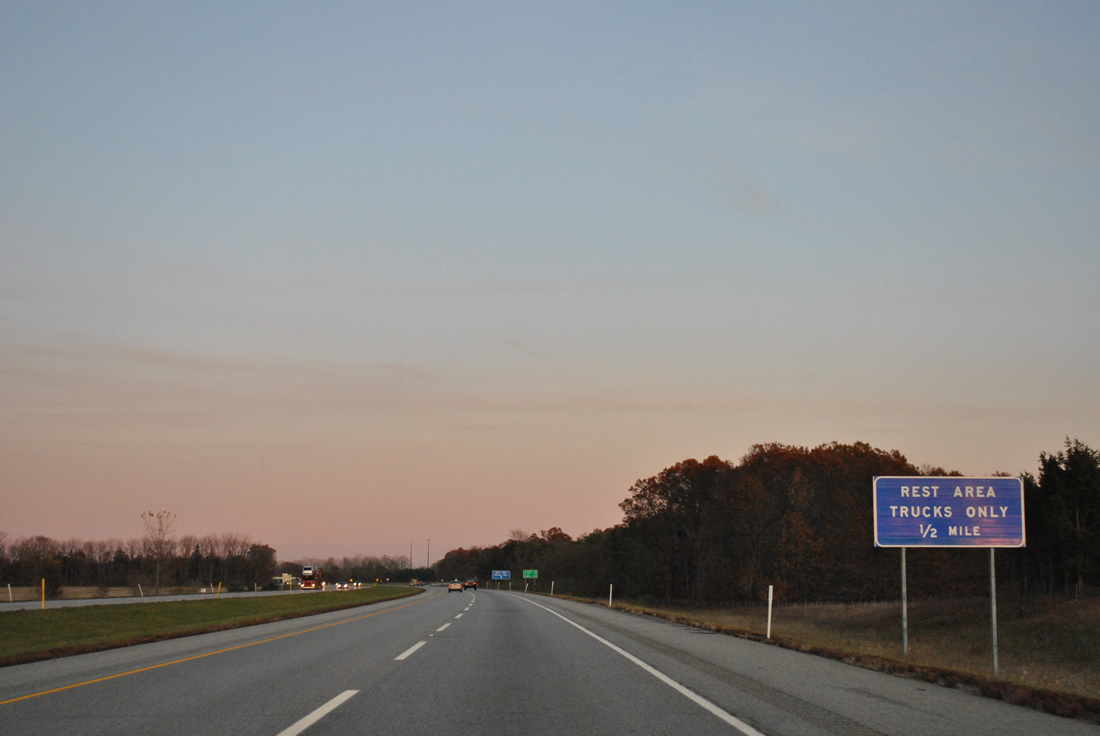
| A second set of truck only rest areas exists along I-80/90 eastbound near Stone Lake. The parking lots take place of former service areas. 11/04/11 |
|
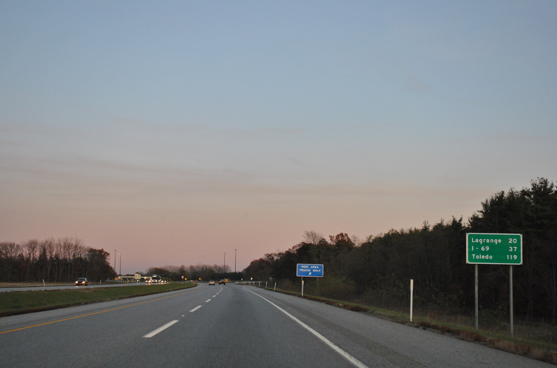
| Lagrange, the seat of the county by the same name, is a 20 mile drive via SR 9 south from Exit 121. Interstate 69 (Exit 144) is 37 miles to the east. 11/04/11 |
|
| A set of shields for I-80/90 follow the truck only rest area on-ramp at the County Road 1200 West over crossing. 11/04/11 |
|
| Drivers enter Lagrange County at the County Road 1200 West overpass. A county line sign lies just east of the bridge. 11/04/11 |
|
| SR 9 meets the toll road at the lone Lagrange County interchange, midway between Elkhart and Angola at Exit 121. 11/04/11 |
|
| I-80/90 rise to span the Fawn River on the one mile approach to the trumpet interchange (Exit 121) with SR 9. SR 9 constitutes a 196 mile route between the Michigan state line (M-66) and SR 46 east of Columbus. 11/04/11 |
|
| Eastbound I-80/90 at Exit 121 to SR 9. Howe resides two miles to the south along SR 9 at SR 120. Lagrange is 5.6 miles south from there at U.S. 20. Northward, M-66 connects SR 9 with U.S. 12 at Sturgis. 11/04/11 |
|
| Reassurance shields and a distance sign are posted along I-80/90 east between SR 9 and the County Road 100 East overpass ahead of the Fawn River. Interstate 69 is the next exit, 22 miles to the east. Angola is a seven mile drive south via I-69 and SR 172. 11/04/11 |
|
| The fourth eastbound service area resides in northeastern Lagrange County near Brighton. 19 miles separate the Gene Stratton Porter Travel Plaza from the final Indiana Toll Road service area near Fremont. 11/04/11 |
|
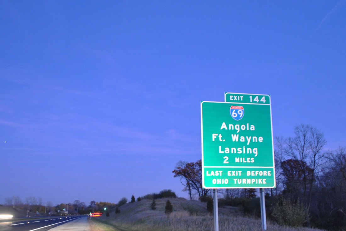
| Interstate 69 and I-80/90 come together near Jamestown in Steuben County. Pictured here is the two mile guide sign for the 356 mile route between Indianapolis and Port Huron, Michigan. Exit 144 is the final Indiana Toll Road interchange, with travelers continuing east defaulting onto the Ohio Turnpike beyond the east gate main line toll plaza. 11/04/11 |
|
| The trumpet interchange and access road at Exit 144 links with I-69, SR 120, and SR 127 south. Interstate 69 travels north to Jamestown before exiting Indiana for Coldwater, Michigan. Pokagon State Park and the Steuben County seat of Angola are within eight miles of I-80/90 via I-69 or SR 127 south from adjacent SR 120. 11/04/11 |
|
| I-80/90 pass over Interstate 69 ahead of the Exit 144 ramp to the north-south freeway. I-69 ventures south 41 miles to Fort Wayne, Indiana's second largest city, and north 79 miles north to Michigan's capital city. The freeway replaced U.S. 27 from Fort Wayne (Exit 114) northward to Lansing, with signage for the US route removed in 2002. 11/04/11 |
Page Updated 01-20-2012.


 East
East