|
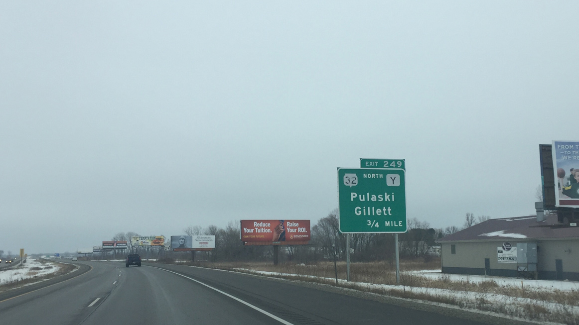
| STH-32 leads south from Pulaski to combine with the STH-29 expressway east in 0.75 miles at Exit 249. CTH-V north ties into the upcoming diamond interchange from Isaar and the town of Seymour in adjacent Outagamie County. 01/24/16 |
|
| Wis 32 doubles as the Red Arrow Highway along its nearly 326 mile trek across the state from Land O' Lakes at the Michigan state line to Pleasant Prairie at Illinois. 01/24/16 |
|
| STH-29/32 overlap for 7.4 miles to Shawano Avenue in the village of Howard. 01/24/16 |
|
| Travelers reach the city of Green Bay in eight miles just beyond Interstate 41 [U.S. 41]. 01/24/16 |
|
| Wis 29/32 briefly enter the northeast corner of Outagamie County and next intersect CTH-U (County Line Road). A J-turn takes drivers onto CTH-U north to Kunesh. 01/24/16 |
|
| CTH-U south straddles the Brown County and Hobart village line through the Oneida Indian Reservation to eventually reach Interstate 41 [U.S. 41] near Wrightstown. 01/24/16 |
|
| CTH-VV ventures east from Isaar to end at STH-29/32 through north Hobart. 01/24/16 |
|
| A dumbbell interchange (Exit 255) joins the Wis 29/32 expressway with CTH-FF (Sherwood Street north / Hillcrest Road south) in one mile. 01/24/16 |
|
| Speed limits increase to 70 miles per hour as Wis 29 upgrades to a limited access freeway to Interstate 41. 01/24/16 |
|
| Centennial Centre Boulevard was realigned to parallel the freeway east to CTH-FF in Hobart when STH-29 was upgraded. The interchange (Exit 255) was built from 2013 to 2014 and included expansion of CTH-FF south to the boulevard and north to parallel Shawano Avenue (CTH-C) in Howard. 01/24/16 |
|
| A directional T interchange joins Wis 29/32 with Interstate 41 [U.S. 41] in one mile. I-41 circles the west side of Green Bay north to Howard and south to Ashwaubenon. 01/24/16 |
|
| Construction from 2009 to a ribbon cutting ceremony held on June 26, 2014 upgraded the STH-29, STH-32 and U.S. 41 exchange to include high speed flyovers ranging from 50 to 75 feet in height. The work was completed as part of the $1.5-billion U.S. 41 project through Brown and Winnebago Counties.1 01/24/16 |
|
| STH-29 east departs for CTH-EB (Packerland Drive south / Cardinal Drive north) at a dumbbell interchange. STH-29 follows Shawano Avenue southeast into downtown Green Bay while STH-32 travels briefly south along I-41 to Mason Street. 01/24/16 |
|
| Confirming marker posted for STH-29 beyond the exit ramp to CTH-EB. 02/23/16 |
|
| STH-29 east enters the dumbbell interchange with CTH-EB (Packerland Dive). Packerland Drive travels south to the Green Bay Botanical Garden and Mason Street (STH-54). 02/23/16 |
|
| The STH-32 mainline spans STH-29 and CTH-EB ahead of Shawano Avenue. Cardinal Lane continues CTH-EB north as STH-29 leaves for I-41 and Green Bay. 02/23/16 |
|
| Traffic bound for STH-29 east leaves for Shawano Avenue ahead of a roundabout joining Packerland Drive and Cardinal Lane. 02/23/16 |
|
| Shawano Avenue continues STH-29 east from south Howard into Green Bay. 02/23/16 |
|
| The Wis 32 freeway parallels Shawano Avenue on its approach to I-41. 02/23/16 |
|
| A dumbbell interchange joins Shawano Avenue with Interstate 41 below the flyovers of the I-41/Wis 32 exchange. 02/23/16 |
|
| Duck Creek Parkway hooks south from Cardinal Drive to meet Wis 29 at a roundabout ahead of Interstate 41. 02/23/16 |
|
| The flyover ramp from Wis 32 east to I-41 north rises over Wis 29 at the ramp departure for I-41 south. The freeway joins Green Bay with Appleton to the southwest. 02/23/16 |
|
| Traveling under the I-41 freeway mainline along Shawano Avenue (STH-29) east. 02/23/16 |
|
| Entering the three-lane roundabout on the east side of I-41. I-41 ends four miles north of STH-29 at Lineville Road (Exit 173), while U.S. 41 resumes course to Suamico, Abrams, and Marinette. 02/23/16 |
|
| A sixth roundabout along Wis 29 east joins Shawano Avenue with Taylor Street as the trunk highway formally enters Green Bay. 02/23/16 |
|
| Wis 29 (Shawano Avenue) passes by St. Mary's Hospital as the arterial enters an urban area of Green Bay. 02/23/16 |
|
| One of the oldest McDonald's restaurants in Wisconsin is located at Shawano Avenue (STH-29) east at Alfran Street. The classic sign dates back to 1959 and was given historical status in 2002.2 02/23/16 |
|
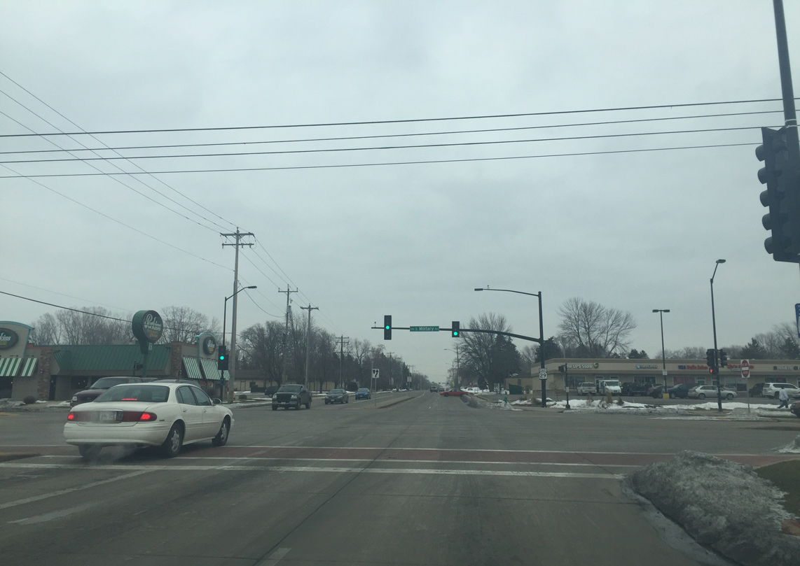
| Eastbound Shawano Avenue at Military Avenue. Military Avenue represents the pre-freeway route of U.S. 41 and former alignment of U.S. 41 Business, which was decommissioned by 2004. 02/23/16 |
|
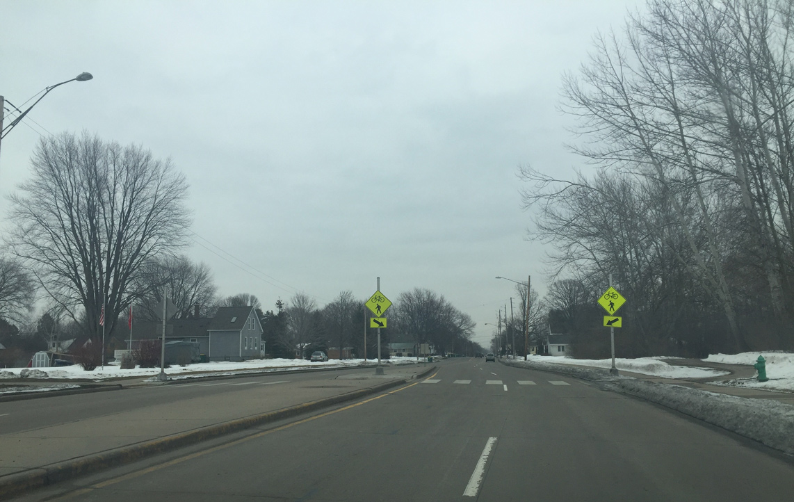
| Wis 29 (Shawano Avenue) crosses the West Side Railroad Trail at Platten Street. Wis 29 previously traveled below grade here under the Milwaukee Road railroad tracks. The area was filled in and Shawano Avenue was rasied by 2005. 02/23/16 |
|
| Shawano Avenue intersects Oneida Street at the Maple Arches and Fisk Addition neighborhoods. Oneida Street south heads through the Western Corridor community to intersect Wis 32 (Mason Street) en route to Lambeau Field. 02/23/16 |
|
| Walnut Street continues Wis 29 southeast into Downtown Green Bay at Oakland Avenue. Walnut Street while separating the Fort Howard and Seymour Park neighborhoods. 02/23/16 |
|
| Ashland Avenue leads north from STH-29 (Walnut Street) to Fort Howard Park while heading south becomes a part of STH-32 from Mason Street to Ashwaubenon. 02/23/16 |
|
| Broadway Street lines the west side of the Fox River, connecting Walnut Street with part of the Green Bay business district. 02/23/16 |
|
| The CN railroad crossing at Pearl Street results in frequent backups from trains. 02/23/16 |
|
| A double lift bridge carries Wis 29 (Walnut Street) across the Fox River. The 1986-opened span provides a vertical clearance of 11.8 feet. 02/23/16 |
|
| Redevelopment along the Fox River front has taken shape as STH-29 east enters central Green Bay. 02/23/16 |
|
| Eastbound STH-29 (Walnut Street) at Washington Street in Downtown Green Bay. 02/23/16 |
|
| Walnut Street east meets Jefferson Street near the Brown County Courthouse. Wis 29 east combines with Wis 54/57 (Monroe Avenue) two blocks ahead. 02/23/16 |
|
| Motorists are advised to use the left lane from Madison Street as Wis 29 prepares to turn north onto Monroe Avenue. 02/23/16 |
|
| Wis 29 east combines with Wis 54/57 to form a three-way overlap along Monroe Avenue north while Walnut Street continues east as a local street into the Navarino neighborhood. 02/23/16 |
Page Updated 03-08-2016.