
New Jersey Route 90 consists of a 3.22 mile long freeway leading west from NJ 73 at Cinnaminson Township through Pennsauken Township to the tolled Betsy Ross Bridge. The route joins Camden County with Interstate 95 at Philadelphia, Pennsylvania. The Pennsylvania section is signed with NJ 90 references but officially is unnumbered, appearing as SR 67B4 in GIS Data.
The Betsy Ross Bridge opened to traffic on April 30, 1976 after five years of construction and two years of delay due to the incomplete interchange with I-95. The through-truss bridge travels 8,485 feet across the Delaware River at a height of 135 feet.1,2 Until 2000, the span accommodated eight lanes of traffic. It was restriped to provide six lanes and full outside shoulders in fall 2000.2 Tolls are levied in the westbound direction only.
Ramps at the west end of the bridge included several stubs intended for the unconstructed Pulaski Expressway. A few of these were later used as part of new ramps to Aramingo Avenue west of Interstate 95. Work here ran from 1997 to December 1999.
NJ 90 opened from the Betsy Ross Bridge to U.S. 130 initially. A short extension followed with construction underway in March 1986 to extend the six-lane freeway to NJ 73. The $23 million project was completed on October 25, 1988. The unconstructed portion of NJ 90 extended south from NJ 73 to Interstate 295 and the NJ Turnpike. It was dropped due to environmental concerns with Pennsauken Creek and lack of funding by 1980.3
 East East |
 | Ramps from Interstate 95 combine beyond a stub left over from the unconstructed Pulaski Expressway to form the eastbound beginning of the Betsy Ross Bridge at the Bridesburg section of Philadelphia. An original pull through panel, since replaced with a sign for Route 90, referenced the connection with U.S. 130. 12/23/01 |
 | Until 2000, the number of lanes traveling east or west across the Betsy Ross Bridge varied depending upon time of day. A movable zipper barrier allowed officials to adjust capacity for the morning and evening commutes. This changed with the installation of a permanent barrier between three lanes in each direction. 12/23/01 |
 | Descending into Burlington County, New Jersey on the Betsy Ross Bridge (Route 90) eastbound. Lane control signals and guide signs attached to a girder type sign bridge reference the connections to Interstate 295 and the New Jersey Turnpike via Route 90 to Route 73. 12/23/01 |
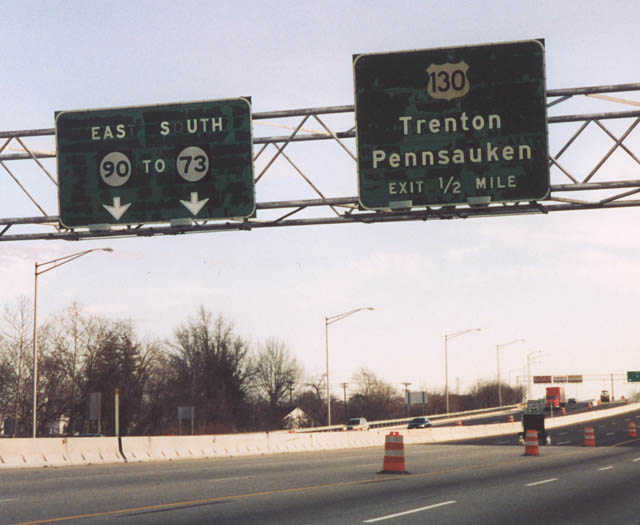 | Former button copy signage posted after the removed Betsy Ross Bridge eastbound toll plaza, one half mile ahead of U.S. 130. The control cities for U.S. 130 featured the state capital of Trenton, 30 miles to the north and nearby Pennsauken to the south. Sign replacements altered the destinations to Cinnaminson and Camden. U.S. 130 is a heavily traveled corridor through the Camden and greater Philadelphia metropolitan area. 12/23/01 |
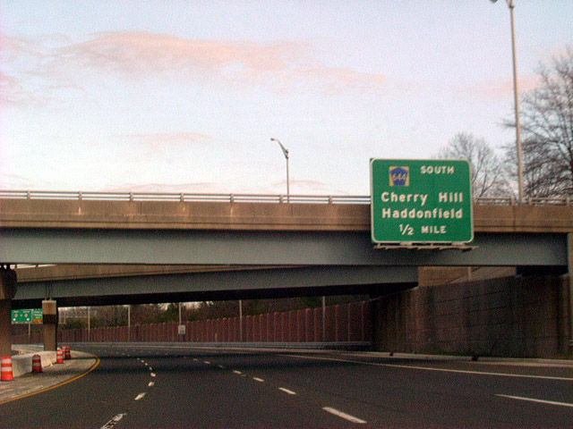 | One half mile west of the CR 644 (Haddonfield Road) off-ramp on Route 90 east. Crossing overhead are ramps to and from U.S. 130 (Crescent Boulevard). Haddonfield Road stems southward from the Route 73 and U.S. 130 interchange to East Pennsauken, Haddonfield and Cherry Hill. 12/23/01 |
- Betsy Ross Bridge, Delaware River Port Authority (DRPA).
- Betsy Ross Bridge (NJ 90), Philadelphia Area Roads, Crossings and Exits.
- NJ 90 Freeway, Philadelphia Area Roads, Crossings and Exits
Photo Credits:
12/23/01 by AARoads
Connect with:
Interstate 95
U.S. 130
Route 73
Page Updated 04-22-2014.