|
| Leaving the commercialized intersection with SR 586 (Curlew Road) on U.S. 19 south. An single point urban interchange (SPUI) is planned at SR 586 as part of the freeway upgrade to U.S. 19 southward to Evans Road. 03/11/15 |
|
| Downtown Clearwater is a six mile drive to the southwest. Downtown St. Petersburg lies 20 miles to the south via U.S. 19 and U.S. 19 Alternate. 03/11/15 |
|
| Upgrades to U.S. 19 southward will add a frontage road system to the ones at Evans Road. A slip ramp ahead of Boy Scout Road will serve local interests, including those to Republic Drive west while the at-grade intersection with Hammock Pine Boulevard here will be eliminated. 03/11/15 |
|
| East of Dunedin, U.S. 19 upgrades into a freeway leading south to Pinellas Park. The aforementioned frontage road system commences at Evans Road, a local road connecting U.S. 19 with CR 501 (Belcher Road). 03/11/15 |
|
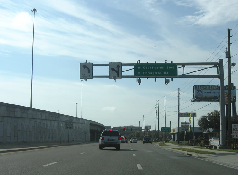
| SR 580 (Main Street) meets U.S. 19 at a SPUI utilizing the adjacent frontage roads. SR 580 travels between U.S. 19 Alternate (Broadway) in Downtown Dunedin and U.S. 92 (Dale Mabry Highway) in Tampa. Locally the state road serves the Countryside and Enterprise areas. 03/11/15 |
|
| The exit for SR 580 (Main Street) at Countryside departs U.S. 19 south. SR 580 east leads to Oldsmar and Town 'n' Country in Hillsborough County. 08/24/13 |
|
| The southbound frontage road connects with Countryside Boulevard to Belcher Road (CR 501) south and Enterprise Road. 01/02/06 |
|
| The U.S. 19 mainline shifts southeast by Westfield Countryside Mall to pass over Countryside Boulevard. 03/11/15 |
|
| Final work on the freeway upgrade for U.S. 19 at Enterprise Road was completed in Spring 2015. 01/14/16 |
|
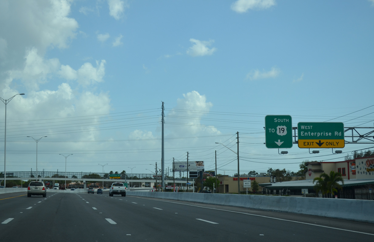
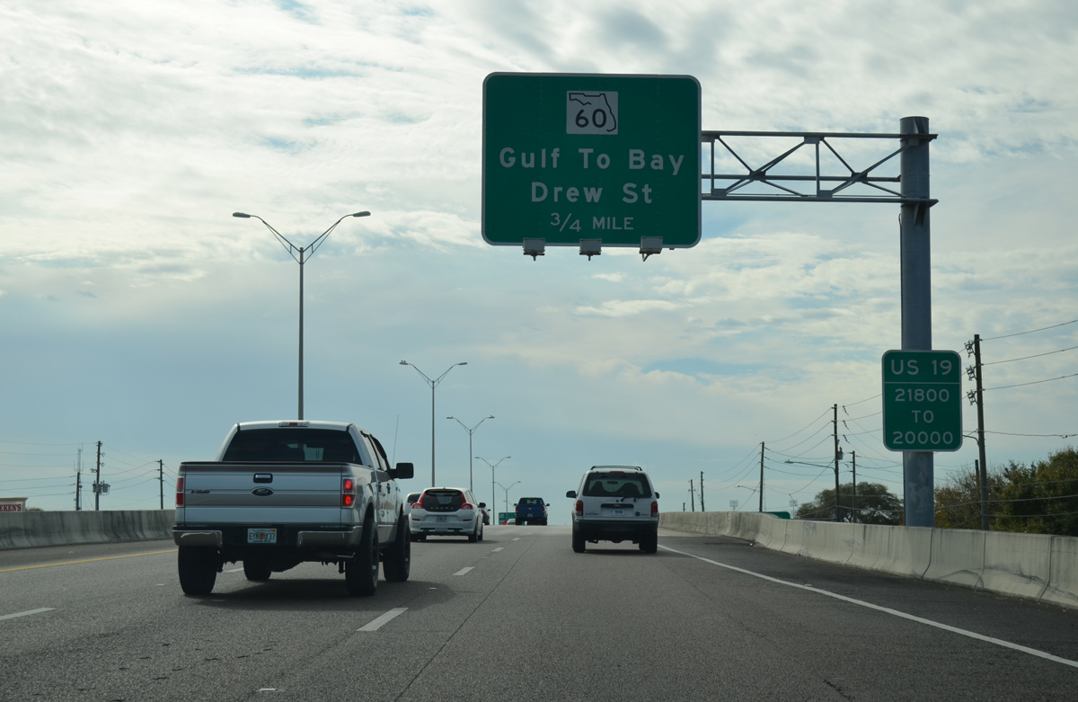
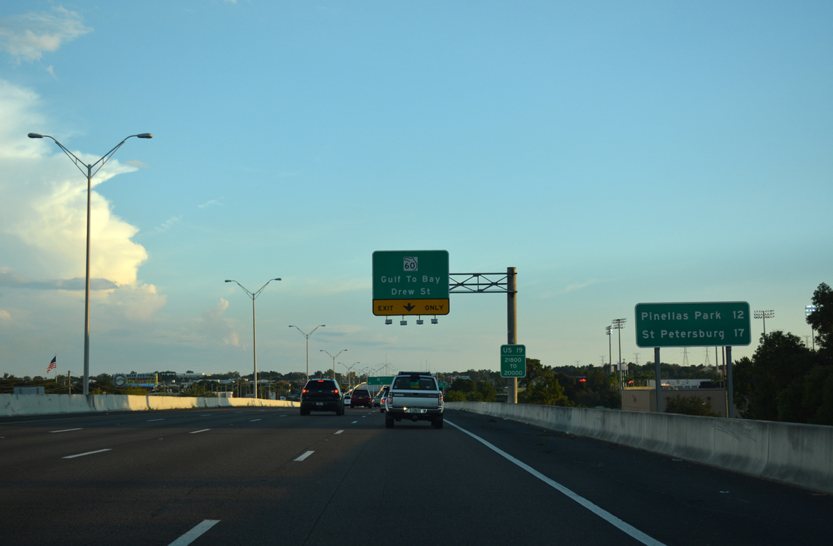
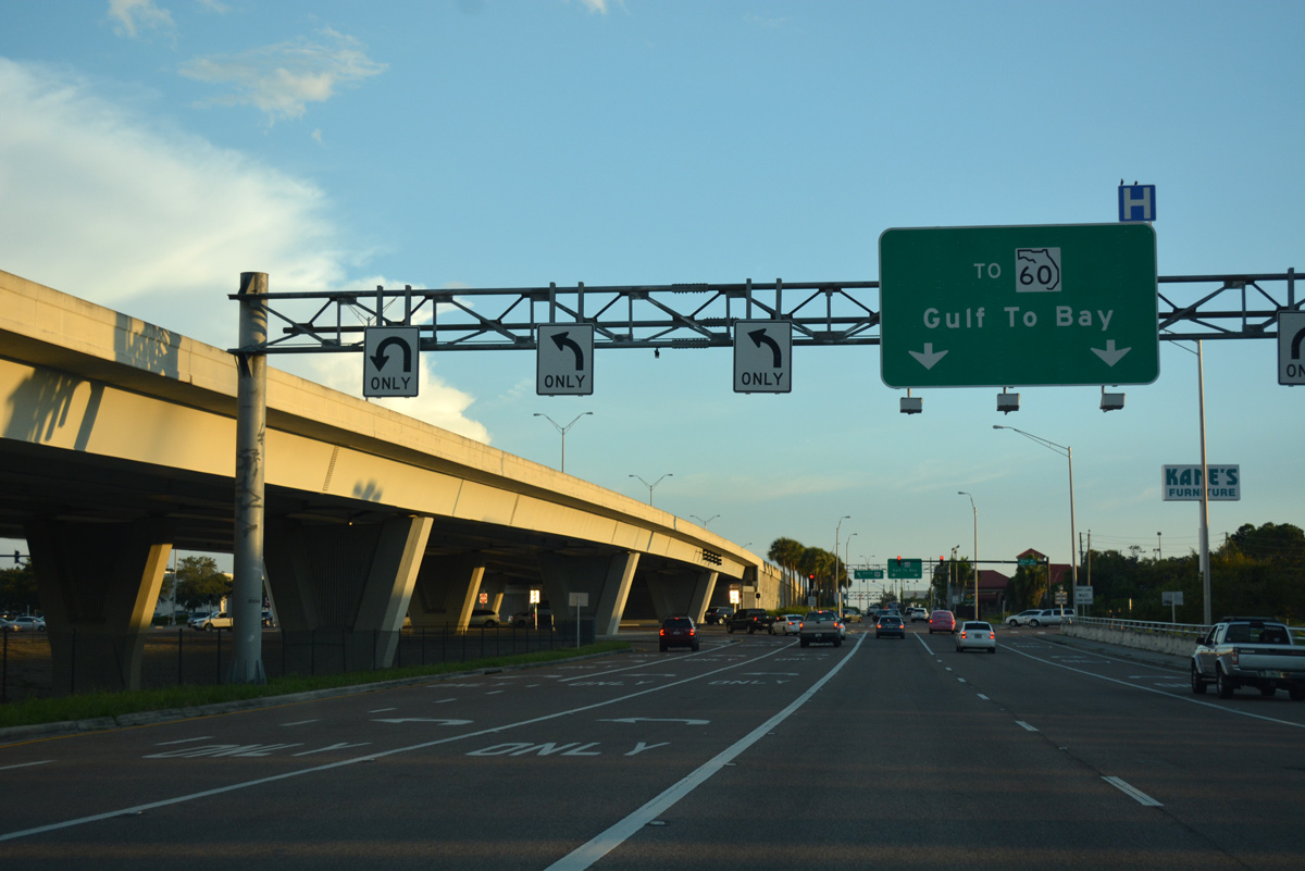
| A single southbound off-ramp serves both Sunset Point Road (CR 576) and NE Coachman Road (SR 590) due to their close proximity to one another. A similar configuration joins U.S. 19 south with both Drew Street and SR 60 (Gulf to Bay Boulevard). 01/14/16 |
|
| Enterprise Road loops northwest from the adjacent service road to SR 580. The road is discontinuous east across U.S. 19 en route to Safety Harbor. 03/11/15 |
|
| A slip ramp departs next for the adjacent frontage road south by 1st Avenue N in Clearwater. Passing above in this scene is Duke Energy Trail, a multi-use bicycle and pedestrian path. 01/14/16 |
|
| The Frontage Road exit serves a number of businesses and apartments otherwise inaccessible due to the freeway along U.S. 19. The ensuing off-ramp joins the service road ahead of Sunset Point Road (CR 576) west to U.S. 19 Alternate (Edgewater Drive) off Clearwater Harbor. 01/14/16 |
|
| A slip ramp provides return access to U.S. 19 south from the Enterprise Road area just ahead of the exit for Sunset Point Road (CR 576) east to Safety Harbor. 01/14/16 |
|
| An auxiliary lane leads southward to the frontage road ramp for Sunset Point Road and SR 590 (NE Coachman Road). Split into two sections, SR 590 connects U.S. 19 with Safety Harbor and U.S. 19 Alternate (Myrtle Avenue) west in Downtown Clearwater. SR 590 also straddles the waters of Safety Harbor from Enterprise Road north to SR 580 along Phillippe Parkway. The section through Downtown Safety Harbor was turned over to city maintenance. 01/14/16 |
|
| All traffic bound for either CR 576 (Sunset Point Road) or SR 590 (NE Coachman Road) in Clearwater departs U.S. 19 south in unison. 01/14/16 |
|
| Six lanes of U.S. 19 ascend over Sunset Point Road in this scene. Ramps tie into southbound and from northbound along this stretch. 03/11/15 |
|
| The frontage road advances south to SR 590 (NE Coachman Road) beyond the CR 576 on-ramp. SR 590 angles southwest along NE Coachman Road to overtake Drew Street west from CR 528. 01/14/16 |
|
| Passing over SR 590, U.S. 19 south next reaches the Drew Street (CR 528) and SR 60 (Gulf to Bay Boulevard) off-ramp in 0.75 miles. 01/14/16 |
|
| Interchange sequence signs are posted consistently along the U.S. 19 freeway through Pinellas County. 01/14/16 |
|
| SR 60 connects Downtown Clearwater with the city of Tampa via Courtney Campbell Causeway. The state road ends along Memorial Causeway linking the Clearwater central business district with Clearwater Beach. 08/24/13 |
|
| A distance sign appears along U.S. 19 south of SR 590. Pinellas Park lies 12 miles ahead while St. Petersburg is 17 miles away. 10/01/16 |
|
| The forthcoming exit serves Drew Street (CR 528) west to SR 580 near Skycrest in Clearwater and CR 611 (McMullen-Booth Road) and Bayshore Boulevard in Safety Harbor. 10/01/16 |
|
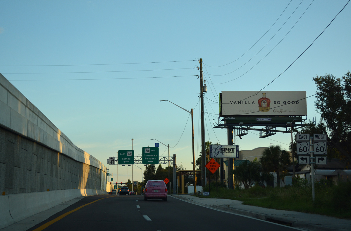
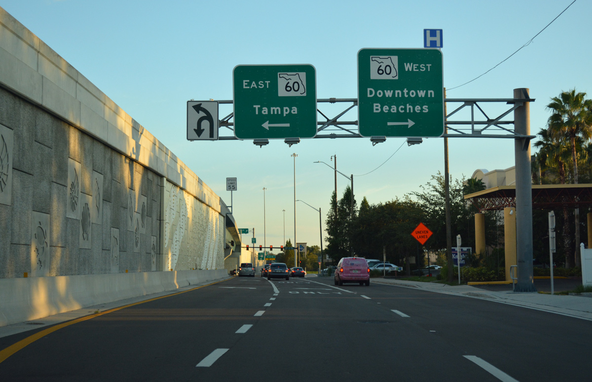
| Two lanes part ways with U.S. 19 south for Drew Street (CR 528) and SR 60 (Gulf to Bay Boulevard). Gulf to Bay Boulevard comprises a busy arterial route east to Courtney Campbell Causeway across Old Tampa Bay and west to Court Street on the south side of Downtown Clearwater. 11/15/16, 10/01/16 |
|
| Passing through the single point interchange with Drew Street along the south side frontage road leading toward SR 60 (Gulf to Bay Boulevard). 10/01/16 |
|
| Beyond the SR 60 (Gulf to Bay Boulevard) underpass, an off-ramp branches away from U.S. 19 for Harn Boulevard west and Seville Boulevard east. 11/15/16 |
|
| The original SPUI between U.S. 19 and SR 60 was reconstructed from 2011-2015. This expanded U.S. 19 to six overall lanes with full outside shoulders and partial inside shoulders. 10/01/16 |
|
| Harn Boulevard stems west from the U.S. 19 frontage roads into the Morningside community to Belcher Road. Seville Boulevard serves Clearwater Mall shopping center and a pair of apartment complexes west of Old Tampa Bay. 11/15/16 |
|
| An on-ramp ties onto U.S. 19 south after Seville Boulevard and just ahead of the slip ramp for Nursery Road (CR 474) and Belleair Road (CR 464) west. Both county roads used to intersect U.S. 19 at traffic lights. 11/15/16 |
|
| Nursery and Belleair Roads parallel one another by one quarter mile west from U.S. 19. Nursery Road ends as a subdivision road west of Highland Avenue while Belleair Road extends west to U.S. 19 Alternate outside the town limits of Belleair. 11/15/16 |
|
| A slip ramp joins U.S. 19 south from Belleair Road just beyond Largo Inlet and Allen Creek. The succeeding exit departs in a quarter mile for Whitney Road east to High Point. 11/15/16 |
|
| A half diamond interchange connects U.S. 19 south with the frontage road system ahead of Whitney Road east. 11/15/16 |
|
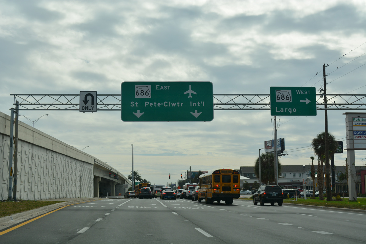
| U.S. 19 passes over Whitney Road ahead of the slip ramp for SR 686. SR 686 (Roosevelt Boulevard) east provides a direct route to St. Petersburg-Clearwater International Airport (PIE). Westward, the state road follows East Bay Drive toward Largo city hall and Belleair Beach as CR 416 (West Bay Drive). 11/15/16 |
|
| The exit for SR 686 near High Point part ways with U.S. 19 south. 11/15/16 |
|
| SR 686 travels overall between U.S. 19 Alternate (Seminole Boulevard) and U.S. 92/SR 687 (4th Street N) at Gandy Boulevard (SR 694 west) in north St. Petersburg. 11/15/16 |
|
| Progressing south from the SPUI with SR 686, U.S. 19 advances to SR 693 (66th Street N). SR 693 follows 66th Street south through the heart of Pinellas Park to the city of South Pasadena.
Succeeding guide signs to CR 296 were replaced during 2016. 08/24/13 |
|
| Two lanes leave U.S. 19 south for SR 693 (66th Street N) at a wye interchange. SR 693 comprises a busy commercial corridor south through Pinellas Park and Kenneth City. SR 693 also represents the southernmost toll free crossing onto the Gulf barrier islands, utilizing Corey Causeway across the Intracoastal Waterway to St. Pete Beach. 08/24/13 |
|
| SR 688 (Ulmerton Road) converges with U.S. 19 at a busy SPUI in east Pinellas Park. The arterial was widened in 2007-08 to eight lanes between SR 693 (66th Street N) and Pinellas County Road 611 (49th Street N). SR 688 east ties into Intestate 275 by Feather Sound in St. Petersburg. 08/24/13 |
|
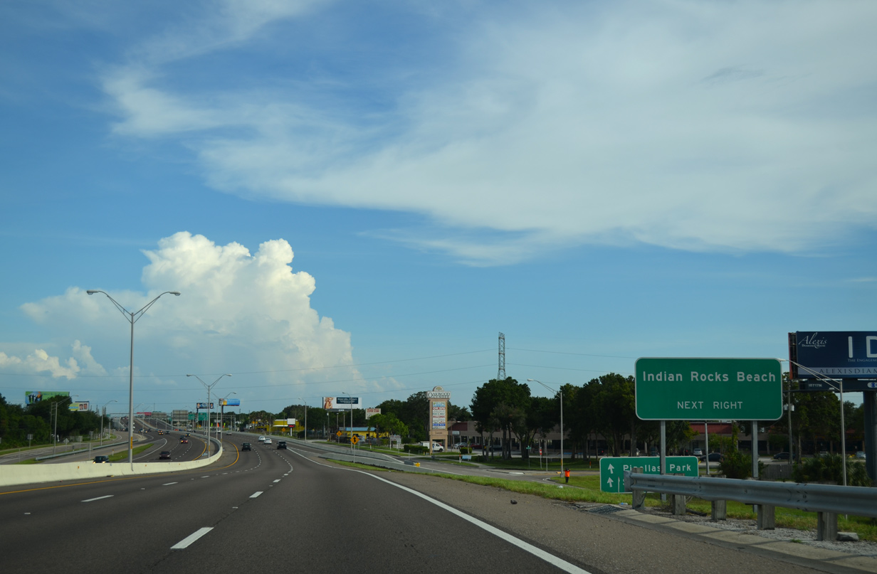
| A supplemental sign references the west end of SR 688 at Indian Rocks Beach. SR 688 lines Ulmerton Road west to Walsingham Road by Anona. SR 688 west of Oakhurst Road to Indian Rocks Beach was originally Florida Secondary Road 694. 08/24/13 |
|
| A slip ramp joins the southbound frontage road ahead of SR 688 (Ulmerton Road). SR 688 travels 13.33 miles overall between Interstate 275 at Exit 31 and Gulf Boulevard (SR 699 south / CR 183 north) at Indian Rocks Beach. 03/11/15 |
|
| U.S. 19 was upgraded to freeway standards from SR 688 south to CR 296 in 2008. A SPUI replaced an at-grade intersection with upcoming Bryan Dairy Road. 08/24/13 |
|
| The U.S. 19 south frontage road intersection with SR 688 (Ulmerton Road). SR 688 east to Interstate 275 leads directly onto the Howard Frankland Bridge north into Tampa. SR 688 west constitutes a busy commercial arterial through Pinellas Park and Largo. 10/22/07 |
|
| Southbound reassurance marker posted for U.S. 19 at the 126th Avenue N under crossing. 03/11/15 |
|
| Interchange sequence sign posted a quarter mile ahead of County Road 296 (Bryan Dairy Road). The freeway on U.S. 19 ends ahead of CR 611 technically, but the stretch is free from traffic lights. 08/24/13 |
|
| East from U.S. 19 to I-275, construction for the Gateway Expressway (SR 690) overlays CR 296. Plans for the elevated toll road include flyovers at U.S. 19. The six year construction for the Gateway Express project commenced in March 2018. 03/07/23 |
|
| CR 296 originates west of Seminole in an unincorporated area. The arterial route crosses Lake Seminole and shifts northward onto Bryan Dairy Road, which eventually upgrades to an expressway ahead of U.S. 19. 08/24/13 |
|
| U.S. 19 heads southeast to a half diamond interchange with 110th Avenue N. A six-ramp parclo interchange follows with CR 611 (49th Street N). 08/24/13 |
|
| 110th Avenue N serves Northfield Manor and other subdivisions to the west and a large series of industrial parks to the east. 08/24/13 |
|
| CR 611 stretches nearly the length of Pinellas County from the Pasco County line by East Lake south to 22nd Avenue S (CR 138) at the city of Gulfport. South from the Bayside Bridge over Old Tampa Bay, the county road doubles as 49th Street N through Pinellas Park. 03/22/16 |
|
| 49th Street N constitutes a commercial boulevard south from U.S. 19 through central Pinellas Park to the Disston Heights neighborhood of west St. Petersburg. 03/22/16 |
|
| A slip ramp ties into U.S. 19 south from 110th Avenue N. CR 611 replaced Florida Secondary Road 691 as a route north to Roosevelt Boulevard and south into St. Petersburg. 03/22/16 |
|
| The Downtown St. Petersburg skyline comes into view along the southern horizon at the loop ramp for CR 611 (49th Street N) north. CR 611 forms an industrial arterial north to St. Pete-Clearwater International Airport (PIE) ahead of the Bayside Bridge. 03/22/16 |
Page Updated 04-20-2018.


 south
south