|
| PA 462 parallels U.S. 30 to the south across the Columbia–Wrightsville Bridge. The concrete arch bridge opened to traffic on September 30, 19301 and was the route of U.S. 30 until 1972. Adjacent pier support remnants are from a railroad bridge that ended operations on March 13, 1958.1 10/13/04 |
|
| Construction of the Wrights Ferry Bridge spanning the Susquehanna River ran between March 1969 and November 21, 1972. Its name commemorates Wright's Ferry, the first crossing of the Susquehanna River established in 1730.2 10/13/04 |
|
| Passing underneath PA 441 (3rd Street / Chickies Hill Road) ahead of the U.S. 30 loop ramp onto Linden Street west to the state route. PA 441 travels 31.6 miles along the east banks of the Susquehanna River from Washington Boro (PA 999) northward to Columbia, Marietta, Bainbridge, Royalton, Middletown and Harrisburg. 10/13/04 |
|
| Concrete roadways remained in use on the stretch between PA 441 and Prospect Road north of Columbia until at least 2009. 10/13/04 |
|
| Prospect Road meanders through southwest Lancaster County from Main Street (old U.S. 230) at Salunga to Ironville, U.S. 30 and PA 462 (Columbia Avenue) outside the borough of Montville. 10/13/04 |
|
| College Avenue links U.S. 30 with PA 462 (Main Street) in Mountville a half mile to the southwest. Stoney Battery Road extends northeast 1.5 miles to PA 23 at Oyster Point. 10/13/04 |
|
| U.S. 30 meets Centerville Road at a folded diamond interchange east of Mountville. 10/13/04 |
|
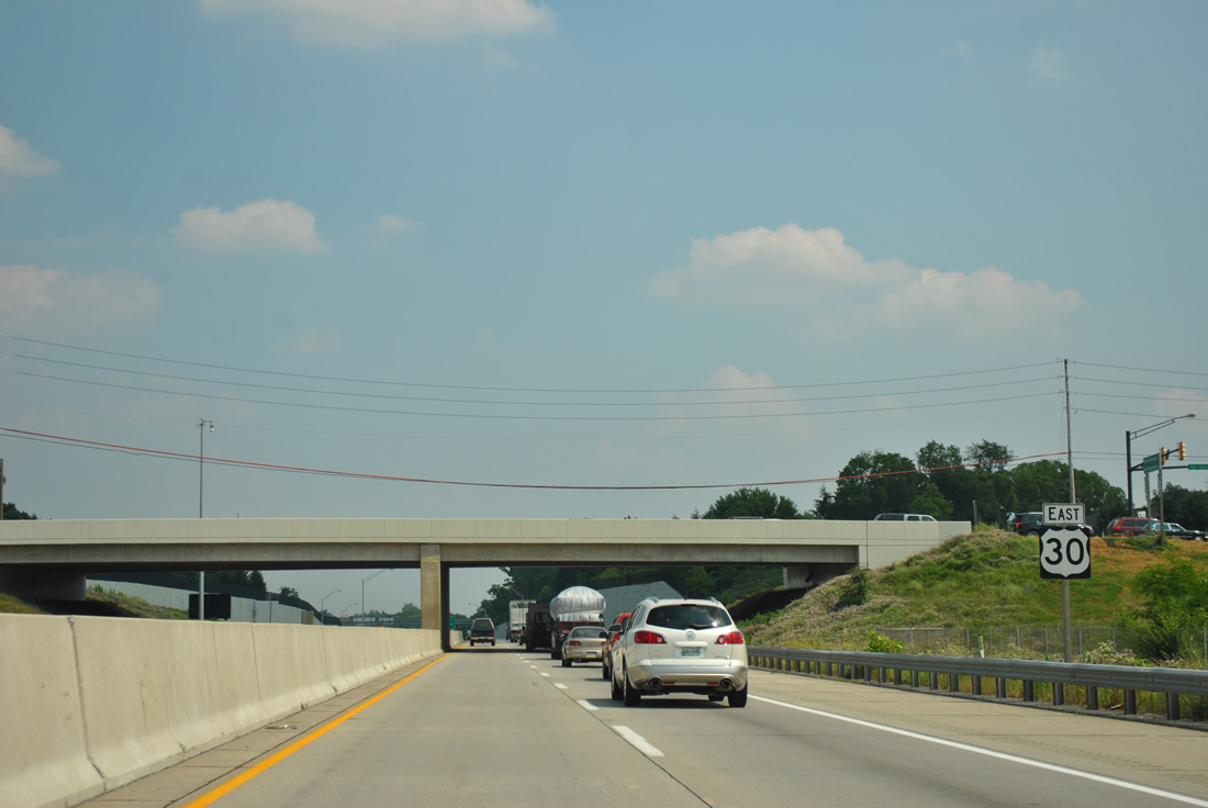
| U.S. 30 east at PA 741 (Rohrerstown Road). All of the freeway along U.S. 30 from PA 741 east around Lancaster was reconstructed between 1996 and 2002. PA 741 loops southward from East Petersburg, Rohrerstown, Wheatland and Millersville. 10/13/04 |
|
| The on-ramp from PA 741 adds an auxiliary lane to Harrisburg Pike on U.S. 30 east. Harrisburg Pike (old U.S. 230) was superseded in importance as the route between Lancaster and Harrisburg with the completion of the freeway along PA 283 to the north. Harrisburg Pike heads two miles southeast to U.S. 222/PA 272 (Prince Street) near Downtown. 10/13/04 |
|
| U.S. 30 eastbound expands to four lanes to exits for PA 72 and the collector distributor roadway (Chester Road) to PA 283 west. PA 72 (Manheim Pike) heads northward from the Downtown Lancaster to East Petersburg, Manheim and ultimately Lebanon. 10/13/04 |
|
| PA 72 (Manheim Pike) passes underneath U.S. 30 at a half diamond interchange. 10/13/04 |
|
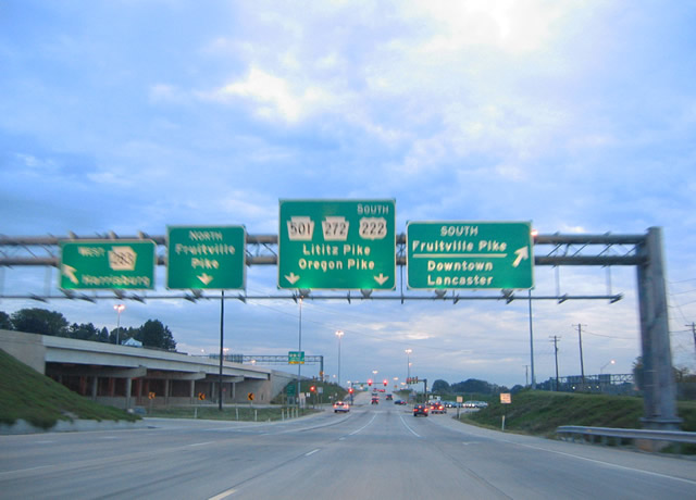
| U.S. 30 converges with the east end of PA 283 at a wye interchange. Construction completed in 2001 redesigned the former trumpet interchange with PA 283 as part of a split diamond interchange with Fruitville Pike, PA 501 (Lititz Pike) and PA 272 (Oregon Pike). 10/13/04 |
|
| Chester Road runs east alongside U.S. 30 from PA 283 to Fruitville Pike. A U-turn ramp joins with York Road west to PA 283. 06/21/12 |
|
| Traffic from PA 283 adds a third through lane for U.S. 30 east and an auxiliary lane to the exit for Chester Road ahead of PA 501 north, U.S. 222 (Lititz Pike) south and PA 272 (Oregon Pike). 06/21/12 |
|
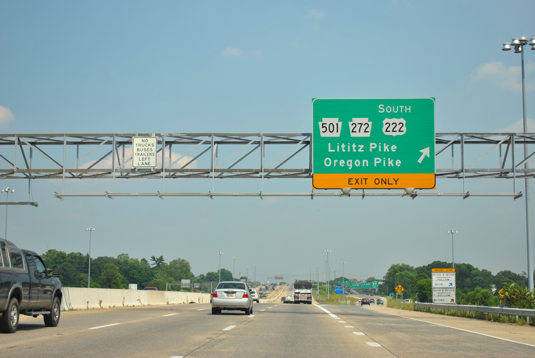
| Intersections along Chester Road at Fruitville Pike, PA 501 (Lititz Pike) and PA 272 (Oregon Pike) replaced three successive cloverleaf interchanges with tight ramps. Fruitville Pike is a commercial arterial leading north from PA 72 (Prince Street / Manheim Pike) to Fruitville and PA 772. 10/13/04 |
|
| A slip ramp follows the Fruitville Pike underpass for Chester Road east to PA 501/U.S. 222 south (Lititz Pike) and PA 272 (Oregon Pike). PA 501 originates at the U.S. 222/PA 272 northbound split with Lititz Pike at Oregon Pike and travels 39.2 miles to Neffsville, Lancaster Airport (LNS), Lititz and Marstown. 10/13/04 |
|
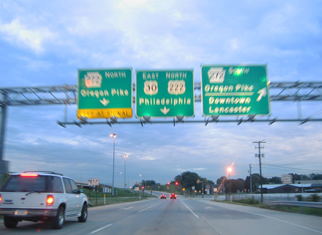
| U.S. 222 north merges onto U.S. 30 east for a brief overlap from Oregon Pike (PA 272) to its freeway leading northeast to Reading in one mile. 10/08/01 |
|
| Another U-turn ramp links Chester Road with York Road west ahead of Lititz Pike. Lititz Pike carries U.S. 222/PA 501 south one half mile to Oregon Pike (PA 272). U.S. 222/PA 272 overlap through Downtown Lancaster to Lyndon, Hollinger and Willow Street. Both routes continue to Cecil County, Maryland. 10/13/04 |
|
| Chester Road continues a short distance from PA 501 to Oregon Pike, which carries U.S. 222 north to U.S. 30 east and PA 272 to Roseville and Oregon along the former U.S. 222. 10/13/04 |
|
| U.S. 222 north joins U.S. 30 east for a third of a mile to a trumpet interchange with the freeway leading north to Reading. The freeway opened between Lancaster and the Berks County line in 1978 and from there north to U.S. 422 at Sinking Spring by 2006. 06/21/12 |
|
| Older guide signs for U.S. 30 east / U.S. 222 north ahead of their split. Reconstruction of U.S. 30 at U.S. 222 was completed in December 2001. Work resulted in the expansion of U.S. 30 to six lanes to PA 23 (Walnut Street). 10/08/01 |
|
| U.S. 222 northbound leaves U.S. 30 east for Akron, Ephrata, Reamstown, Adamstown, and the Reading metropolitan area. The freeway reaches Interstate 76 (Pennsylvania Turnpike) in 16 miles and the city of Reading in 28 miles. 06/21/12 |
|
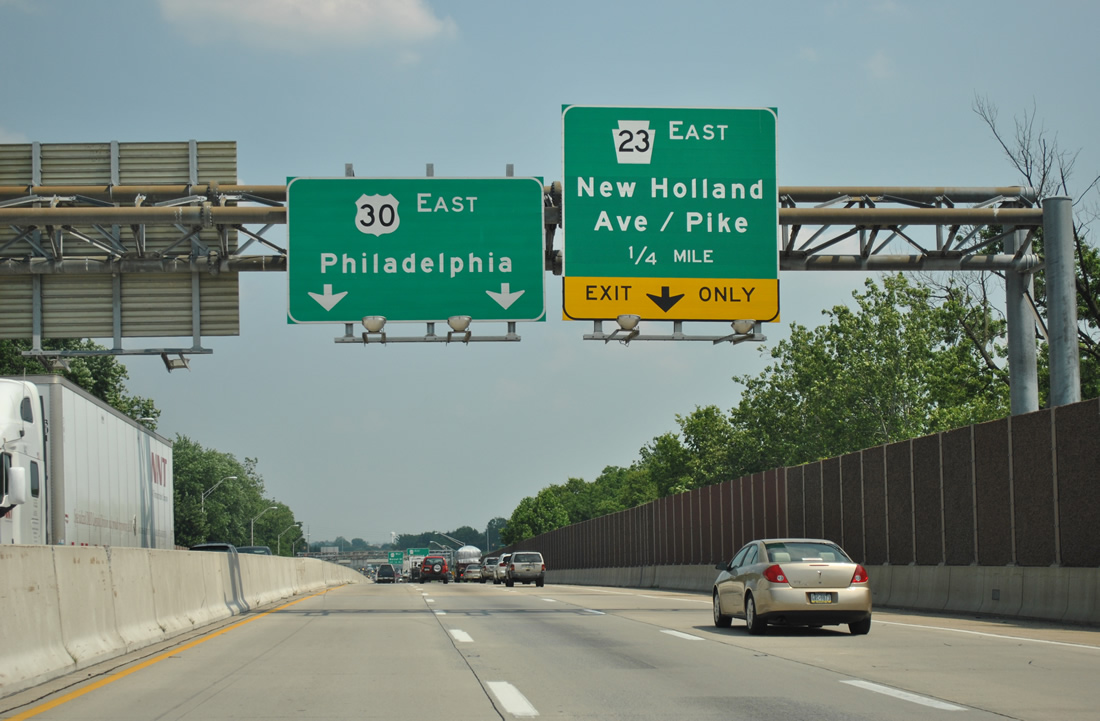
| Turning southeast, U.S. 30 next meets PA 23 (New Holland Pike) east at a diamond interchange. PA 23 east follows New Holland Avenue out of Lancaster to Eden, Leacock, Leola and New Holland. 06/21/12 |
|
| U.S. 30 reduces to four overall lanes at the exit to PA 23 (New Holland Pike). Part of PA 23 to Walnut Street until November 1992, New Holland Pike becomes New Holland Avenue southwest into the Lancaster street grid. 06/21/12 |
|
| PA 23 west combines with U.S. 30 eastbound for 0.6 miles. 06/21/12 |
|
| Spanning Conestoga Creek, U.S. 30/PA 23 advance to a parclo interchange with Walnut Street. Opened November 20, 1992, the Walnut Street extension is a 1.5 mile long controlled access taking PA 23 west from U.S. 30. The alignment was built with provisions for the planned expressway taking PA 23 east to New Holland. 06/21/12 |
|
| PA 23 follows Walnut Street west to Downtown Lancaster. A roadway stub at the exchange with U.S. 30 was to connect with an expressway to New Holland. Planned in the 1960s, the new route for PA 23 was partially constructed in the 1970s, from just east of U.S. 30 to PA 772. Opposition against the roadway mounted before it was completed and the project was subsequently abandoned. 06/21/12 |
|
| A confirming marker for U.S. 30 stands above PA 23 on Walnut Street. 06/21/12 |
|
| U.S. 30 travels through eastern reaches of the Lancaster city limits ahead of the exit for Greenfield Road. Greenfield Road serves a number of industrial parks and adjacent retail between Willow Road and Lincoln Highway (PA 462). 06/21/12 |
|
| A parclo interchange joins U.S. 30 (Lancaster Bypass) with Greenfield Road. Reconstruction altered the interchange from a folded diamond that utilized Hempstead Road on the east side. 06/21/12 |
|
| Curving more to the south, U.S. 30 leaves the city limits of Lancaster by Greenfield Station, crossing over both Norfolk Southern and AMTRAK railroad tracks. 06/21/12 |
|
| PA 340 (Old Philadelphia Pike), a 30.1 mile route from Lancaster to Thorndale, meets U.S. 30 at a three-quarter diamond interchange in 0.25 miles. 06/21/12 |
|
| Old Philadelphia Pike (PA 340) branches northward from PA 462 (Lincoln Highway) at Bridgeport to Smoketown, Bird in Hand and Intercourse. PA 340 stays on a parallel course to U.S. 30 east throughout its entire alignment. 06/21/12 |
|
| U.S. 30 merges with PA 462 (Lincoln Highway) east at a traffic light with Oakview Road. 06/21/12 |
|
| U.S. 30 eastbound shield assembly posted below PA 340 (Old Philadelphia Pike).
Originally a loop ramp departed ahead for PA 340. That ramp was replaced with a new entrance ramp. 06/21/12 |
|
| The on-ramp from PA 340 forms a third eastbound lane to PA 462 (Lincoln Highway). PA 462 heads west along old U.S. 30 to a one way couplet of Orange (west) and Kings (east) Streets across Downtown Lancaster. 06/21/12 |
|
| PA 462 (Lincoln Highway) follows all of old U.S. 30 from Lancaster west to Columbia and York. 06/21/12 |
|
| U.S. 30 follows a sweeping ramp over PA 462 to the freeway end at Oakview Road and an adjacent shopping center. 06/21/12 |
|
| A turn-off joins the ending PA 462 (Lincoln Highway) east with a shopping center on the southwest quadrant of U.S. 30 and Oakview Road. 06/21/12 |
|
| Oakview Road serves a number of apartment and town home communities north and south of Lincoln Highway at Greenland. U.S. 30 continues along a congested arterial east to the Downingtown Coatesville bypass. 06/21/12 |
|
| Harvest Road angles southeast from Hobson Road to meet U.S. 30 (Lincoln Highway) opposite Mennonite School Road at this traffic light. 06/21/12 |
|
| Tanger Outlets line the south side of U.S. 30 (Lincoln Highway) east of Mill Creek. Dutch Wonderland amusement park lies on the north side with a signal at the main entrance. 06/21/12 |
|
| Additional big box retail is located along U.S. 30 ahead of and at the intersection with Witmer Road. 06/21/12 |
|
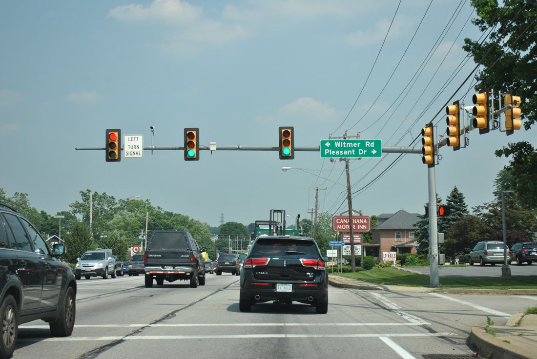
| Witmer Road is another road connecting U.S. 30 (Lincoln Highway) with PA 340 (Old Philadelphia Pike). Pleasant Drive ties into this signal from a small subdivision. 06/21/12 |
|
| Willowdale Drive follows, joining U.S. 30 with a second outlet center to the south and a subdivision west of PA 896 (Eastbrook Road). 06/21/12 |
|
| PA 896 crosses U.S. 30 (Lincoln Highway) at the next signal from Eastbrook Road to the north and Hartman Bridge Road to the south. 06/21/12 |
|
| PA 896 constitutes a multi state route from PA 340 at nearby Smoketown to U.S. 13 at Boyds Corner, Delaware. PA 896 runs 33.6 miles along a mostly rural route through eastern Lancaster and southwestern Chester Counties. 06/21/12 |
|
| PA 896 connects Lancaster with Strasburg, three miles to the south. The Railroad Museum of Pennsylvania is located nearby along PA 741. 06/21/12 |
|
| East from PA 896, U.S. 30 becomes more rural, with traffic counts dropping from 29,000 to 18,000 (2011 counts). PA 896 takes the excess traffic southward to Strasburg, with 10,000 vpd recorded in 2011 north of the borough and 5,000 south of it. 06/21/12 |
Page Updated 05-23-2013.

 East
East


 North
North