|
| I-87/440 (Cliff Benson Beltline) arcs northeast alongside U.S. 64 from I-40 across Walnut Creek in southeast Raleigh. 12/15/16 |
|
| Prior to 2009, signage for I-440 used inner and outer cardinal directions instead of east/west banners. Older assemblies included a graphic of the state capitol. This assembly was posted along the beltline eastbound near Walnut Creek Park. 05/30/07 |
|
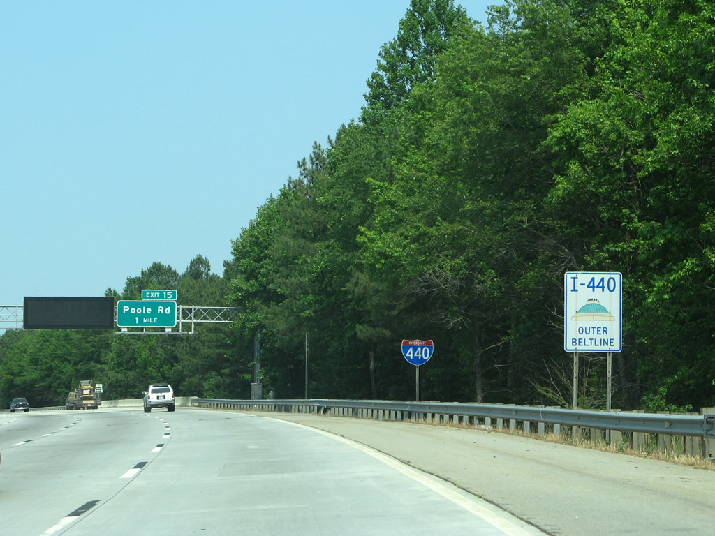
| Poole Road (SR 1007) meets I-87/440 and U.S. 64 at a diamond interchange (Exit 15) near Oak View Park. 05/31/21 |
|
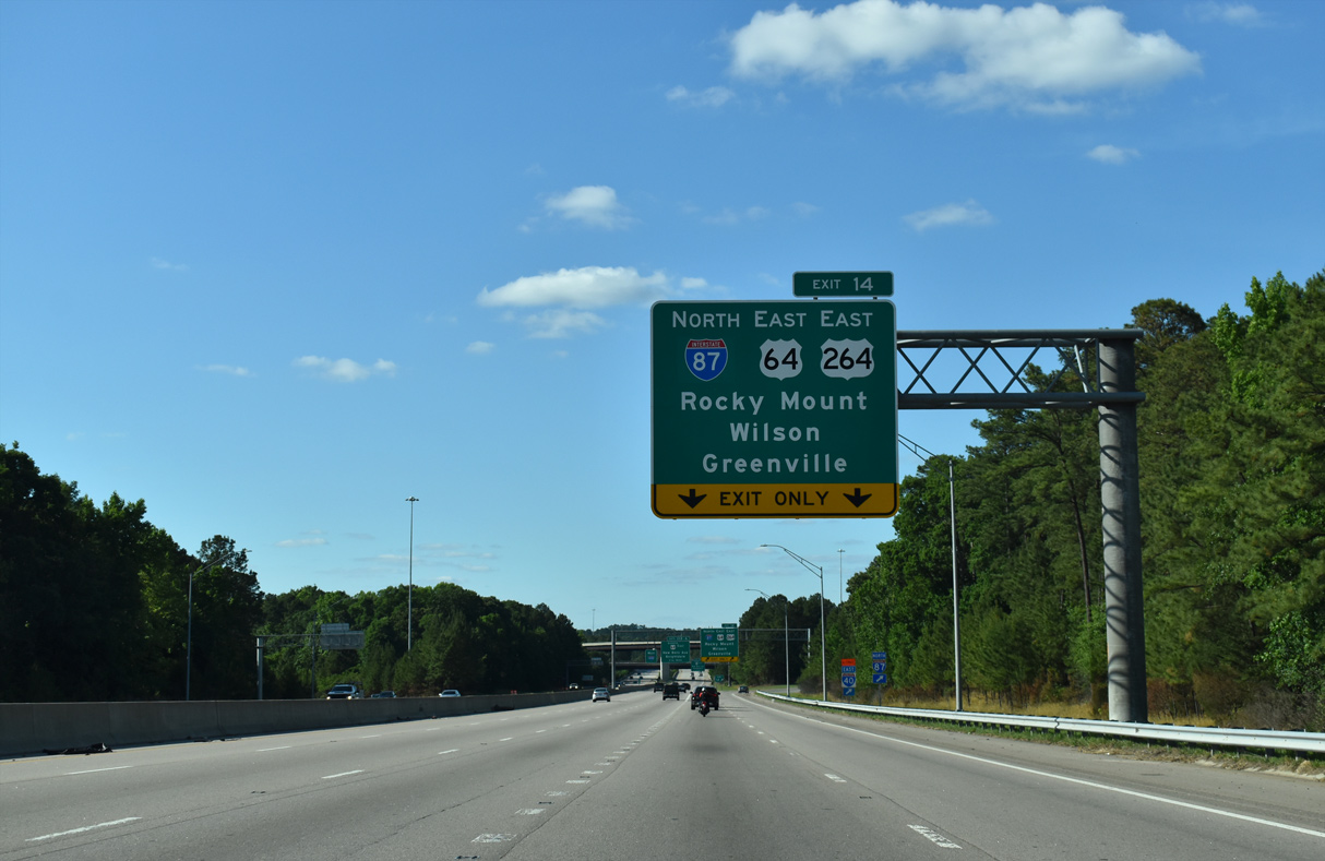
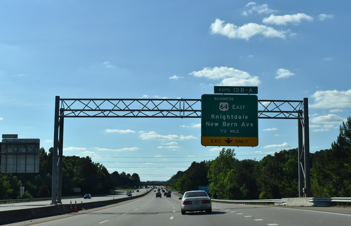
| I-87 north / U.S. 64 east split with the Cliff Benson Beltline at Exit 14 in 1.5 miles. New Bern Avenue (U.S. 64 Business), the prior route of U.S. 64/264 east of the beltline until July 2005, follows in 2.75 miles. 05/31/21 |
|
| Poole Road (SR 1007) weaves through residential neighborhoods west from Exit 15 to New Bern Avenue at College Park. The four lane arterial serves a number of industrial parks east at New Hope Road. 05/31/21 |
|
| Exit 15 leaves I-87 north / I-440 west / U.S. 64 east to Poole Road. Poole Road winds eastward to Wendell south of the Knightdale Bypass (I-87/U.S. 64-264). U.S. 64 between Raleigh and I-95 near Rocky Mount was renumbered as I-495 in December 2013. The inclusion of U.S. 64 east from I-95 to Williamston as a future Interstate corridor in 2016 resulted in the renaming of I-495 to I-87. 05/31/21 |
|
| Interstate 440 west expands to five overall lanes ahead of Exit 14 for I-87 north / U.S. 64-264 east. I-87 overlays the ensuing 4.00 miles of the Knightdale Bypass. The remainder of the route east to Zebulon and Williamston is a future corridor. 05/31/21 |
|
| U.S. 64 joins Raleigh with the Outer Banks east of Williamston. U.S. 264 travels alongside I-87 north/U.S. 64 east 17 miles to Zebulon, where it branches southward along Future I-587 to Wilson and Greenville. 05/31/21 |
|
| U.S. 64 Business joins I-440 north 1.08 miles to Exit 13 B, where it turns east along New Bern Avenue to the town of Knightdale. 05/31/21 |
|
| Flyovers at the directional T interchange with Interstate 87 pass above I-440 as the beltline spans both Crabtree Creek and a Norfolk Southern Railroad line. 12/15/16 |
|
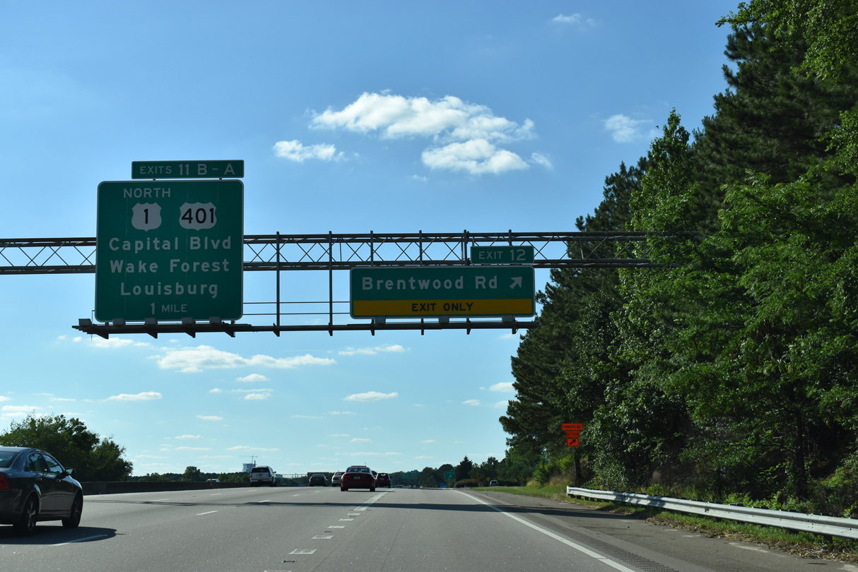
| I-440 turns northwest ahead of Exits 13 A/B for New Bern Avenue and U.S. 1/401 (Capital Boulevard). 05/31/21 |
|
| The first confirming marker for Interstate 440 westbound. 05/31/21 |
|
| An auxiliary lane opens westbound from I-87 to Exit 13 B for Knightdale. New Bern Avenue meets the beltline at a six-ramp parclo interchange. Loop ramps from New Bern Avenue to I-440 were previously removed. 05/31/21 |
|
| U.S. 64 Business (New Bern Avenue) constitutes a commercial arterial east through Knightdale. The bannered route reconvenes with U.S. 64 in 9.3 miles. 05/31/21 |
|
| New Bern Avenue (SR 2911) west from Exit 13 A is the former alignment of U.S. 64 to Downtown Raleigh. U.S. 264 previously ended at I-440 until the Knightdale Bypass opened in 2005. 05/31/21 |
|
| Paralleling a Norfolk Southern Railroad line to the east, Interstate 440 angles northwest across Marsh Creek. 05/31/21 |
|
| The entrance ramp from U.S. 64 Business (New Bern Avenue) forms a westbound auxiliary lane to Exit 12 for Brentwood Road. 05/31/21 |
|
| Right in right out (RIRO) ramps at Exit 12 connect Interstate 440 with Brentwood Road on westbound and Yonkers Road along eastbound. 05/31/21 |
|
| Brentwood Road stems north from Exit 12 by a large industrial park to Raleigh Boulevard (SR 2204) en route to the Brentwood neighborhood north of U.S. 1/401 (Capital Boulevard). 05/31/21 |
|
| Exit 12 leaves I-440 west one mile from the directional cloverleaf interchange (Exit 11) with U.S. 1 north and U.S. 401 along Capital Boulevard. 05/31/21 |
|
| Entering the three quarter cloverleaf interchange (Exits 7A/B) with U.S. 70/NC 50 (Glenwood Avenue) on I-440 westbound. Exit 7A provides access to both U.S. 70/NC 50 eastbound toward Downtown Raleigh and Ridge Road south. 12/31/03 |
|
| I-440/U.S. 1 curve southward ahead of the parclo interchange (Exit 5) with Lake Boone Trail. Lake Boone Trail is an multi lane boulevard between Blue Ridge Road and U.S. 70/NC 50 (Glenwood Avenue) through the Ridgewood neighborhood of the city. 12/31/03 |
|
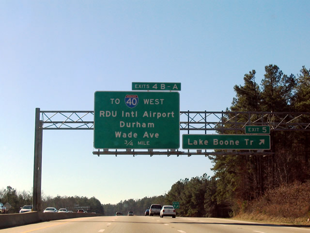
| Exit 5 departs I-440/U.S. 1 for Lake Boone Trail. The ensuing off-ramps connect with Wade Avenue (Raleigh Chapel Hill Expressway). Briefly a part of Interstate 40 at the onset of the its extension into the capital city, Wade Avenue constitutes a freeway between the belt line and I-40 at Exit 289. 12/31/03 |
|
| The Wade Avenue freeway is a part of SR 1728, which extends 5.82 miles west from U.S. 70/NC 50 by the Glenwood community to I-40. The freeway provides a cutoff to I-40 west toward Durham and Raleigh-Durham International Airport (RDU). Exit 4A links with Wade Avenue east through the Ridgewood and Edgewood neighborhoods of the city. 12/31/03 |
|
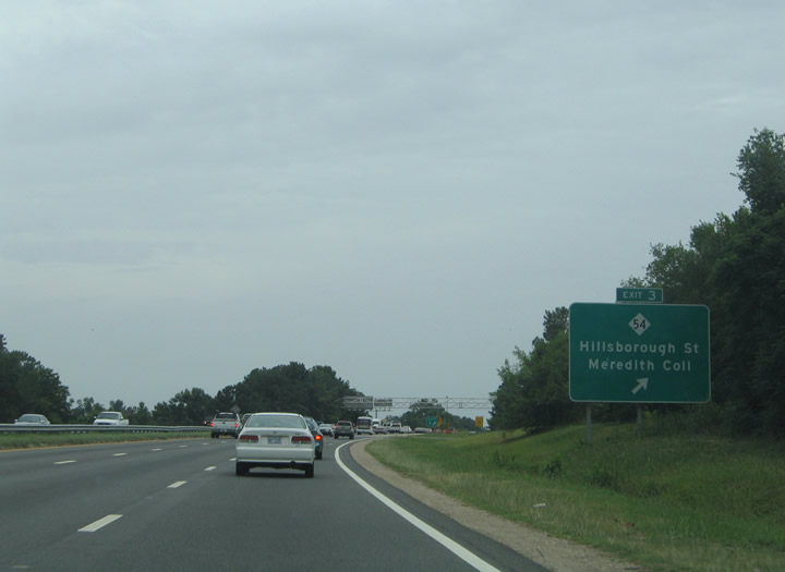
| Underway in 2019-23, the I-440 Improvement Project adds a flyover ramp as part of the interchange upgrade at Wade Avenue. Advancing south, I-440/U.S. 1 next meet NC 54 (Hillsborough Street) at Exit 3. The state route runs alongside a CSX Railroad west to Cary and east to Downtown Raleigh. Points of interest for Exit 3 include the JC Raulston Arboretum, William Peace University and the NC State College of Veterinary Medicine. 07/12/05 |
|
| A folded diamond interchange joins the Cliff Benson Beltline with NC 54 (Hillsborough Street) at Exit 3. NC 54 begins here and heads 1.10 miles west to Wendover and 2.76 miles to I-40 at the Cary city line. Hillsborough Street (SR 3007) extends 2.02 miles east to the campus of North Carolina State University. 07/12/05 |
|
| The $475 million I-440 Improvement Project modernizes the oldest stretch of the Cliff Benson Beltline and widens the freeway to six overall lanes. The beltway honors Cliff Benson, Sr. who was the Transportation Secretary under Democratic Governor Dan Moore between 1965 and 1969. 07/12/05 |
|
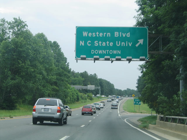
| I-440 Improvement Project construction reconfigures the forthcoming directional cloverleaf interchange (Exit 3) with Western Boulevard into a DDI. 07/12/05 |
|
| Former Benson Beltline reassurance sign posted by the Ligon Street underpass. 07/12/05 |
|
| Western Boulevard (SR 1102) is an arterial route joining North Carolina State University and Cary. 07/12/05 |
|
| Western Boulevard (SR 1012) leads 1.08 miles west to become Hillsborough Street (SR 5808). Hillsborough Street continues the drive west into the city of Cary. East from I-440, Western Boulevard expands into a divided parkway en route to Martin Luther King, Jr. Bouelvard and Shaw University south of Downtown Raleigh. 07/12/05 |
|
| Exit 2B leaves I-440/U.S. 1 for Western Boulevard (former U.S. 64) west. 07/12/05 |
|
| Exit 2A loops onto Western Boulevard eastbound for the campus of North Carolina State University and Downtown Raleigh. 07/12/05 |
|
| A half diamond interchange (Exit 1D) joins I-440 west with Melbourne Road to the Hinton and Wynnewood neighborhoods in west Raleigh. The I-440 Improvement Project eliminates the ramp intersection with Deboy Street. 07/12/05 |
|
| The final reassurance marker for I-440 stands ahead of the Melbourne Road overpass. 07/12/05 |
|
| I-440 follows a more linear course through residential areas north of Lake Johnson to I-40/U.S. 64. 07/12/05 |
|
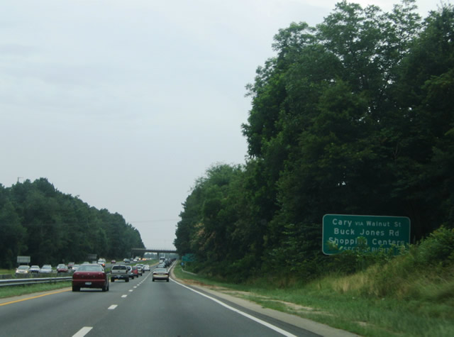
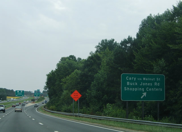
| A lengthy c/d roadway system for Interstate 40 separates from I-440/U.S. 1. It extends southwest along the U.S. 1 freeway to ramps with Buck Jones Road and Walnut Street in Cary. 07/12/05 |
|
| The succeeding exit joins I-440/U.S. 1 (Cliff Benson Beltline) with Jones Franklin Road (SR 1319). 07/12/05 |
|
| Entering the parclo interchange (Exit 1C) with Jones Franklin Road on Interstate 440 westbound. Jones Franklin Road stems south from Hillsborough Street near Wendover to Macedonia in Cary. 07/12/05 |
|
| Advancing west from Jones Franklin Road, I-440/U.S. 1 reach the c/d roadway (Exits 1B/A) for I-40 in one quarter mile. 07/12/05 |
|
| A second supplemental sign directs motorists onto the c/d roadway for the subsequent ramps from U.S. 1 south to Cary. 07/12/05 |
|
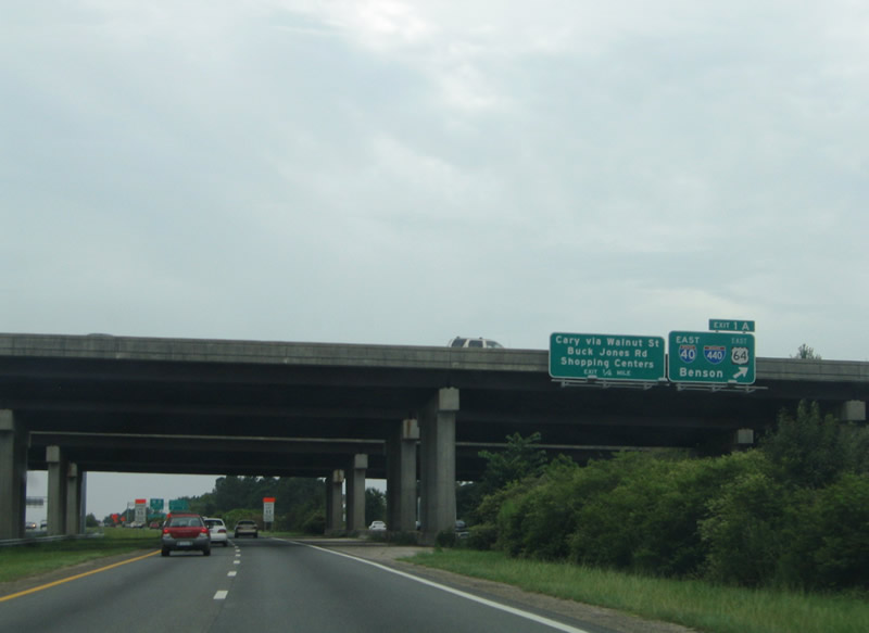
| Westbound I-440 at the split with the c/d roadway for the cloverleaf interchange (Exits 1B/A) with Interstate 40 and U.S. 64 east. U.S. 1 continues along a freeway southwest through Cary, Apex and Sanford. 07/12/05 |
|
| I-40 west runs along the Cary and Raleigh city line from I-440 to Lake Crabtree. The freeway continues from there to Raleigh-Durham International Airport (RDU) and Research Triangle Park. 07/12/05 |
|
| Exit 1B separates from the c/d roadway for Interstate 40 west to Durham, Burlington and Greensboro. A loop ramp (Exit 1A) follows for the 7.5 mile long overlap of I-40/U.S. 64 east across Raleigh. 07/12/05 |
|
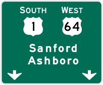
| An end shield for I-440 precedes the departure of Exit 1A. I-40 turns southeast from Raleigh to Garner, Benson (where it meets I-95) and Wilmington. Westbound U.S. 64 combines with U.S. 1 south for 3.79 miles through Cary. 07/12/05 |
Page Updated 01-30-2023.


 North
North  West
West  East
East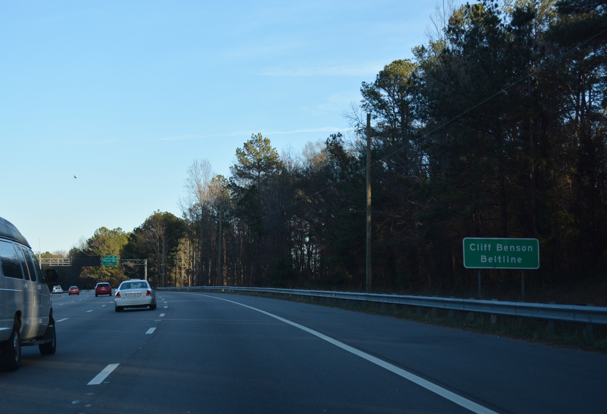


 South
South