|
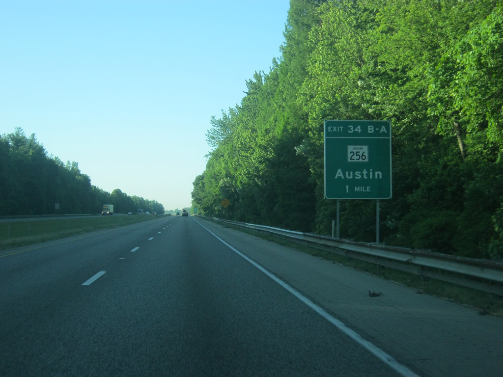
| At the one mile approach to Interstate 65's interchange with SR 256 at Austin. SR 256 travels for 26.7 miles from its western terminus with SR 39 in Washington County to the Jefferson County seat of Madison where the highway ends at SR 56. Austin is the only major community the highway travels through. 06/16/12 |
|
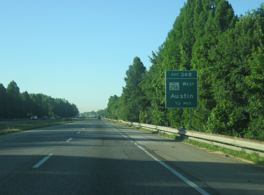
| At the half mile approach to Exit 34 B for SR 256 west. Interestingly, Austin is reached via SR 256 "west" at Exit 34 A. 06/16/12 |
|
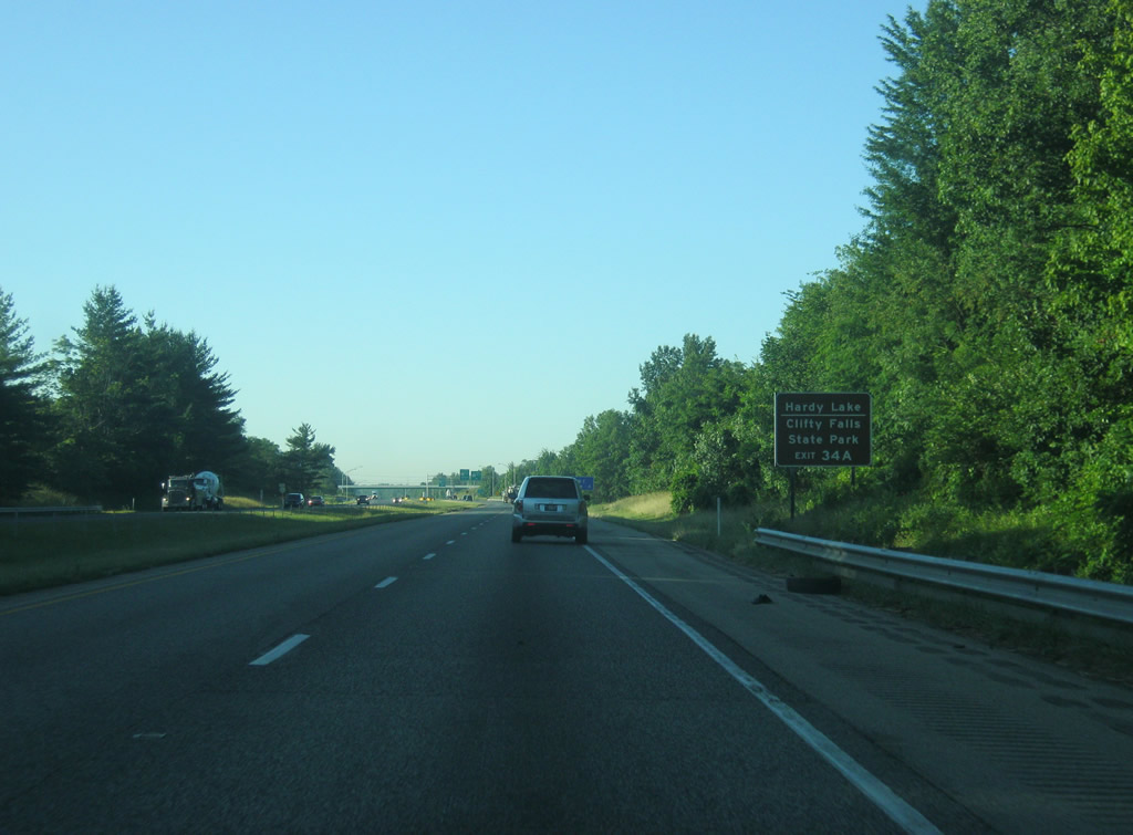
| SR 256 to the east of Austin links up with the Hardy Lake area and with Clifty Falls State Park just west of Madison. 06/16/12 |
|
| Exit 34 B-A consists of a six-ramp interchange with loops in the northwest and southwest quadrants. Here, Exit 34 B turns off onto SR 256 west for its 6.6 mile journey across rural areas to its western terminus with SR 39. 06/16/12 |
|
| Exit 34 B turns off for a loop ramp to SR 256 (Main Street) east to the immediate west of the town of Austin. SR 256 (Main Street) intersects with U.S. 31 in Downtown Austin a half mile away. 06/16/12 |
|
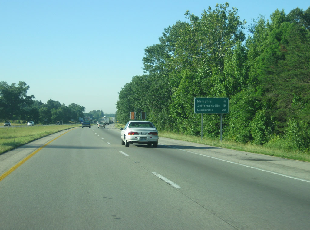
| Scottsburg is now only five miles away. Jeffersonville appears for the first time at 34 miles with Louisville at 35 miles. The Ohio River is about a mile wide in between the downtowns of Jeffersonville and Louisville. 06/16/12 |
|
| Interstate 65 now nears the Scottsburg area at the two mile approach to Exit 29 B-A with SR 56. SR 56 connects Interstate 65 with the Washington County seat of Salem, 20 miles to the west, with Scottsburg, a town of 6,700, a few blocks to the east. 06/16/12 |
|
| SR 56 travels for about 194 miles starting at U.S. 41 in Hazelton and continuing through Petersburg, Jasper, Paoli, Salem, Scottsburg, Madison and Rising Sun before ending at U.S. 50 in Aurora. Exit 29 connects SR 56 with Interstate 65 via a six-ramp interchange with loop ramps in the northwest and southwest quadrants in a similar fashion as Exit 34 B-A. 06/16/12 |
|
| SR 56 to the east of Scottsburg provides the best route to the historic Ohio River town of Madison (23 miles away) and to Hanover College in the town of Hanover (23 miles away). 06/16/12 |
|
| Exit 29 B, leaves Interstate 65 south for SR 56 west en route to Salem. Several restaurants, hotels and stores serve motorists around the vicinity of Exit 29 via both ramps. 06/16/12 |
|
| Exit 29 A leaves Interstate 65 south for SR 56 west (McClain Avenue) which heads east to a junction with U.S. 31 (Gardner Street) a few blocks away in the heart of Scottsburg. 06/16/12 |
|
| The Clark County town of Henryville is next at ten miles. Jeffersonville and Louisville are a half hour away. 06/16/12 |
|
| The Scottsburg water tower dominates the view on southbound Interstate 65 just south of Exit 29 B-A. 06/16/12 |
|
| The Henryville rest area serves southbound Interstate 65 motorists as they approach the Louisville area in two miles. 06/16/12 |
|
| Interstate 65 passes underneath another County Line Road to enter its final Indiana county, Clark County. 06/16/12 |
|
| One mile away from the Henryville rest area. The next rest area on Interstate 65 is 46 miles on the other side of Louisville at the Kentucky Welcome Center. 06/16/12 |
|
| The Henryville rest area turns off of Interstate 65 south. 06/16/12 |
|
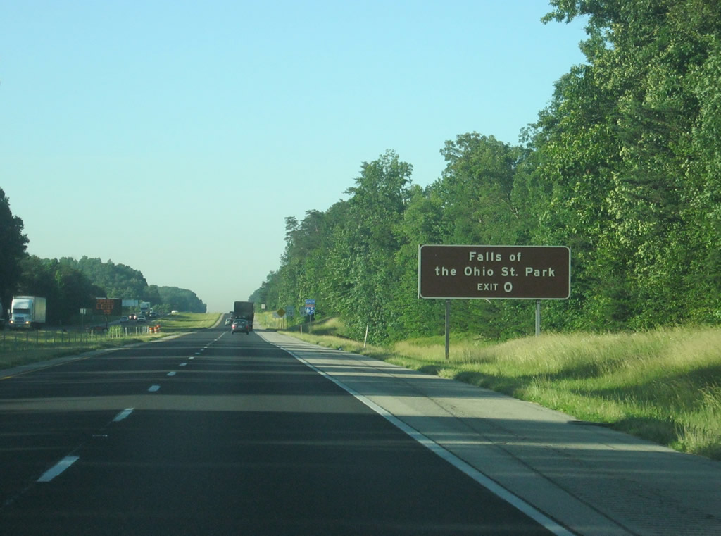
| A sign directs motorists toward the Falls of the Ohio State Park, reached via Exit 0 in Jeffersonville near the Ohio River. 06/16/12 |
|
| The next interchange along Interstate 65 is Exit 19 for SR 160. SR 160 is a windy 23 mile road that begins at SR 430 in Charlestown and travels northwest through the Clark State Forest en route to Salem. 06/16/12 |
|
| Henryville is just east of the interchange at the junction of SR 160 with U.S. 31. Trucks are not advised to use this highway to the west due to its windy nature. Clark State Forest, the oldest state forest in Indiana, can be reached via SR 160 east to U.S. 31 north of Henryville. Charlestown is 8.6 miles to the south of Henryville. 06/16/12 |
|
| Henryville, best known as the birthplace of Colonel Sanders of KFC fame, was devastated by an EF-4 tornado in March 2, 2012 that traveled over 50 miles from southern Washington County eastward across Clark, Scott and Jefferson Counties before ending in Kentucky. The tornado traveled across the Exit 19 diamond interchange en route toward Henryville. 06/16/12 |
|
| The town of Memphis is next south of Exit 19 at four miles. Jeffersonville and Louisville are 19 and 20 miles away respectively. 06/16/12 |
|
| Interstate 65 southbound starts picking up additional traffic as commuters head south from Scott and northern Clark Counties toward the Louisville area. 06/16/12 |
|
| One mile out from Exit 16 with Memphis Road, which serves the nearby town of Memphis at the junction with U.S. 31. 06/16/12 |
|
| To the east, Memphis Road turns to the southeast toward Memphis and ultimately Charlestown. To the west, the road turns to the northwest to SR 160. 06/16/12 |
|
| Exit 16 is a diamond interchange with Interstate 65 and Memphis Road. A grouping of truck stops serves long-distance traffic along Interstate 65 heading south to Louisville. 06/16/12 |
|
| Sellersburg, which marks the beginning of the Louisville suburbs, is eight miles away. Jeffersonville and Louisville are 16 and 17 miles away respectively. 06/16/12 |
|
| Scenes of Interstate 65 as it continues south across Clark County into the urbanized part of the Louisville metropolitan area. 06/16/12 |
|
| Charlestown Road (Former SR 311), ventures northward from I-265/SR 62 at New Albany to Hamburg and U.S. 31 (Indiana Avenue). The former state road meets Interstate 65 at a six-ramp parclo interchange (Exit 9). 06/16/12 |
|
| SR 311 traveled 7.3 miles between its endpoints, but used to continue further south and represents the original U.S. 31W alignment in Indiana. The route was decommissioned in January 2013. 06/16/12 |
|
| Ivy Tech's Southern Indiana campus is located just off of Exit 9 in Sellersburg. 06/16/12 |
|
| Exit 9 turns off of Interstate 65 south onto Charlestown Road (old SR 311) toward the Floyd County seat of New Albany and the town of Sellersburg to the immediate west. 06/16/12 |
|
| Interstate 65 widens to six lanes south of Exit 9 as it is one mile away from the interchange with SR 60. SR 60 ventures southeast from Salem to meet Interstate 65 between Hamburg and Cementville. Salem, the Washington County seat, is the home of famous Civil War politician John Hay and to the first 2% milk. 06/06/12 |
|
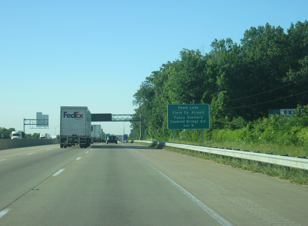
| One half mile north of the diamond interchange (Exit 7) with SR 60. SR 60 ends nearby at U.S. 31 adjacent to the Clark County Airport. Northwest, the state road leaves Hamburg for Bennettsville, New Providence, and the Deam Lake State Recreation Area. 06/06/12 |
|
| One half mile north of the diamond interchange (Exit 7) with SR 60 on I-65. SR 60 ends nearby at U.S. 31 adjacent to the Clark County Airport. Northwest, the state road leaves Hamburg for Bennettsville, New Providence, and the Deam Lake State Recreation Area. 06/16/12 |
|
| Six lanes of Interstate 65 pass under SR 60 at Exit 7. SR 60 totals 62.2 miles from U.S. 31 northwest to U.S. 50 outside Huron. 11/12/04 |
|
| Reassurance shield posted for Interstate 65 southbound after the on-ramp from SR-60. 11/07/11 |
|
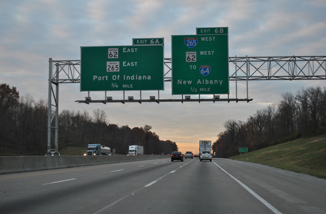
| Next for southbound motorists is the Exits 6B/A directional cloverleaf interchange with Interstate 265 west, SR 265 east, and SR 65. Interstate 265 arcs north of New Albany and Clarksville between Interstates 65 and 64. 11/07/11 |
|
| Distance sign posted eight miles north of Downtown Jeffersonville and nine miles from the Louisville central business district. 11/07/11 |
|
| Alternate Interstate 64 trailblazers were added after the emergency closure of the Sherman Minton Bridge of Interstate 64 across the Ohio River on September 9 2011. The official alternate route utilized Interstate 265 in Indiana and Interstate 65 across the John F. Kennedy Memorial Bridge to Interstate 71 north and Interstate 265 south. The bridge reopened on February 17, 2012. 11/07/11 |
|
| Exit 6B carries drivers onto the westbound beginning of Interstate 265. Interstate 265 travels 6.73 miles with SR 62 to I-64/U.S. 150 outside New Albany. Interstate 65 continues to Georgetown and Evansville.
Sign replacements for Exit 6A replace the destination of Clark Maritime Center with Port of Indiana. 11/07/11 |
|
| Exit 6A loops onto SR 265 east. SR 265 is signed with SR 62, which continues northeast along the Ohio River to U.S. 50 near Cincinnati. The Port of Indiana Jeffersonville, formerly the Clark Maritime Center, accessible via Utica Sellersville Road from the freeway end, is one of three ports in Indiana and sees a lot of farm and industrial exports floated down the river. 11/12/04 |
|
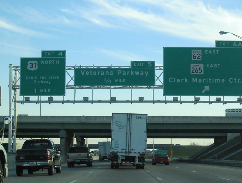
| The next exit is for Veterans Parkway, which was a new road built along with the Interstate 65 rebuilding in 2003. 11/12/04 |
|
| Exit 5 leaves Interstate 65 south for Veterans Parkway; Veterans Parkway leads west through big-box retail based shopping centers to Greentree Boulevard and Green Tree Mall. Eastward the road heads to Charlestown New Albany Turnpike. 11/12/04 |
|
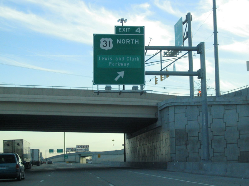
| Exit 4 to U.S. 31 and Lewis and Clark Parkway and the on-ramp from Veterans Parkway crisscross next. U.S. 31 enters from the northeast to form the frontage road system of Interstate 65 through Clarksville. Lewis and Clark Parkway travels south through heavily developed commercial sprawl to an interchange with Brown's Station Way (former U.S. 460 & SR 62). 11/12/04 |
|
| Interstate 65 through Clark County was rebuilt in a $250 million project from 2001 to 2005. The project added lanes, rebuilt all of the roadway, and put many exits into one long collector distributor system. Lewis and Clark Parkway represents former SR 131, a state highway turned back in 2002. 11/12/04 |
|
| Exit 2 joins Interstate 65 with Eastern Boulevard. Eastern Boulevard connects Lewis and Clark Parkway in Clarksville with Spring Street in Jeffersonville. 11/12/04 |
|
| U.S. 31 leaves the Interstate 65 corridor for its own route into Louisville west of downtown Jeffersonville. Exit 1 comprises a slip ramp ahead of the wye interchange with Brown's Station Way. Brown's Station Way represents the former alignment of U.S. 460 through Clarksville. U.S. 460 was decommissioned in Indiana by 1977. 11/12/04 |
|
| Southbound at the Exit 2 off-ramp onto parallel U.S. 31 south for Eastern Boulevard. Exit 1 follows from underneath the Eastern Boulevard overpass for access to Stansifer Avenue west into Clarksville and 10th Street (former SR 62) east into downtown Jeffersonville. 11/12/04 |
|
| U.S. 31 remains along the Interstate 65 frontage road system to West 7th Street. A trumpet interchange connects the service roads with 10th Street east after the 14th Street / Stansifer Avenue intersection. South of there, U.S. 31 spans the George Rogers Clark Memorial Bridge into downtown Louisville. The bridge used to also carry U.S. 460. 11/12/04 |
|
| The first sign of Interstates 64 & 71 (Kennedy Interchange) in Louisville comes into view as Interstate 65 enters downtown Jeffersonville. Exit 0 connects the southbound freeway with Market Street to Riverside Drive and the Falls of the Ohio State Park Interpretive Center. 11/12/04 |
|
| Exit 0 also provides access into downtown Jeffersonville via Court Avenue east. Jeffersonville has about 30,000 people and is the county seat of Clark County. J-ville, as it is locally known, is the birthplace of restaurant chains Rally's and Papa John's pizza. 11/12/04 |
|
| U.S. 31 meanwhile finally parts ways with the Interstate 65 frontage road system after the 9th Street under crossing. The highway bee lines southward to Court Avenue and its cantilever bridge into Louisville. Note that Nashville appears for the first time as a control city for Interstate 65 here. 11/12/04 |
|
| One mile north of the aging Kennedy Interchange between Interstate 64 and adjacent Interstate 71's northbound beginning (Exit 137). The Kennedy Interchange is named for the Kennedy Bridge, Interstate 65's span across the Ohio River. Rebuilding of the junction is planned as part of the Ohio River Bridges project. 11/12/04 |
|
| Exit 0 departs Interstate 65 just north of the John F. Kennedy Memorial Bridge. Market Street passes under U.S. 31's span nearby, ending at Riverside Drive. Court Avenue stems northeast from U.S. 31 directly into the Jeffersonville central business district. 11/12/04 |
|
| Interstate 65 bottlenecks to just two through lanes at the Kennedy Interchange with Interstates 64 and 71. It was built from April 1962 to 1963 and presently handles about 300,000 vehicles per day. 11/12/04 |
|
| The John F. Kennedy Memorial bridge carries three southbound and four northbound lanes above the Ohio River. The main span over the river is 700 feet long. Construction began in 1961 and the bridge opened on December 6, 1963. As this was less than a fortnight since the assassination of the President, there was wide agreement the new bridge be named after JFK. Currently a new bridge is being planned just to the east to carry northbound traffic, while the JFK bridge will be converted to a southbound-only facility. 11/12/04 |
Page Updated 02-26-2013.

 South
South