|
| Exit 226 departs I-69/SR 67 south at SR 9 north (Scatterfield Road) and SR 109 south. SR 9 (Scatterfield Road) goes north through a commercial corridor that stretches into the city of Anderson and onward to Alexandria and Marion. The Hoosier Park Horse Racing Track and Casino are both reached by taking SR 9 (Scatterfield Road) north to Charles Street. To the south, SR 109 goes for 20 miles from Interstate 69 to U.S. 40 in Knightstown. A second segment exists in Northern Indiana from U.S. 30 to U.S. 33 in Whitley and Noble Counties. 11/06/11 |
|
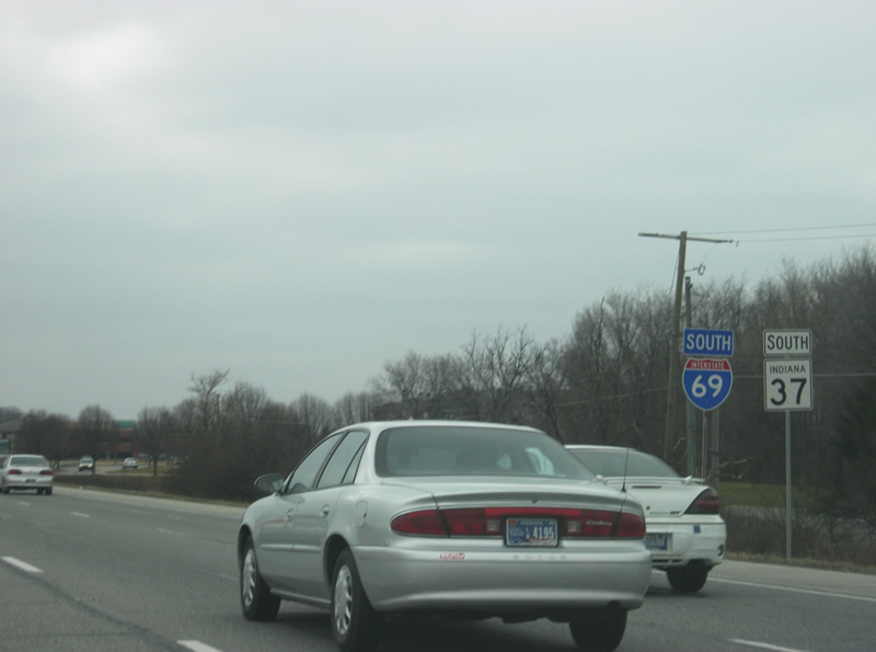
| SR 9 joins I-69/SR 67 south. SR 9 constitutes a 196 mile route between the Michigan state line and SR 46 east of Columbus, going through the communities of LaGrange, Columbia City, Huntington, Marion, Anderson, Pendleton, Greenfield and Shelbyville. SR 67 travels for 199 miles from Vincennes to the southwest north through Indianapolis and Muncie before ending at the Ohio border near Bryant. 11/06/11 |
|
| The small town of Huntsville is five miles away via SR 38 west off of Exit 219. Pendleton is nine miles away via Exit 222 and Indianapolis is 37 miles away. 11/06/11 |
|
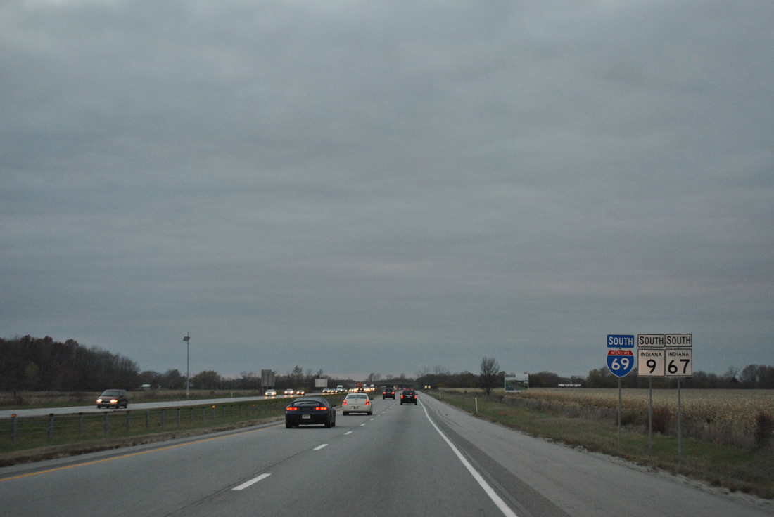
| Now at the half mile approach to Exit 222 off of Interstate 69, SR 9 south & SR 67 south. Formerly, SR 9 and SR 67 were routed along Dr. Martin Luther King, Jr. Boulevard (formerly Pendleton Avenue) out from the city of Anderson before being rerouted along Interstate 69. An Indiana State Police Post is located several miles to the south along SR 67 in Pendleton while the Ivy Tech Community College is located to the north in Anderson. 11/06/11 |
|
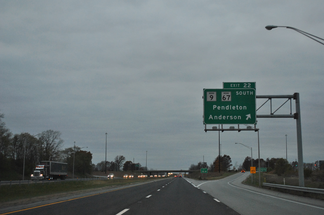
| SR 9/67 south leave I-69 at Exit 222 on the southwest side of Anderson. Both highways head south toward the town of Pendleton where SR 9 heads southward toward Greenfield while SR 67 joins U.S. 36 west toward Indianapolis. SR 38, which used to be routed through Pendleton, joins I-69 southbound for three miles around Pendleton to Exit 219. 11/06/11 |
|
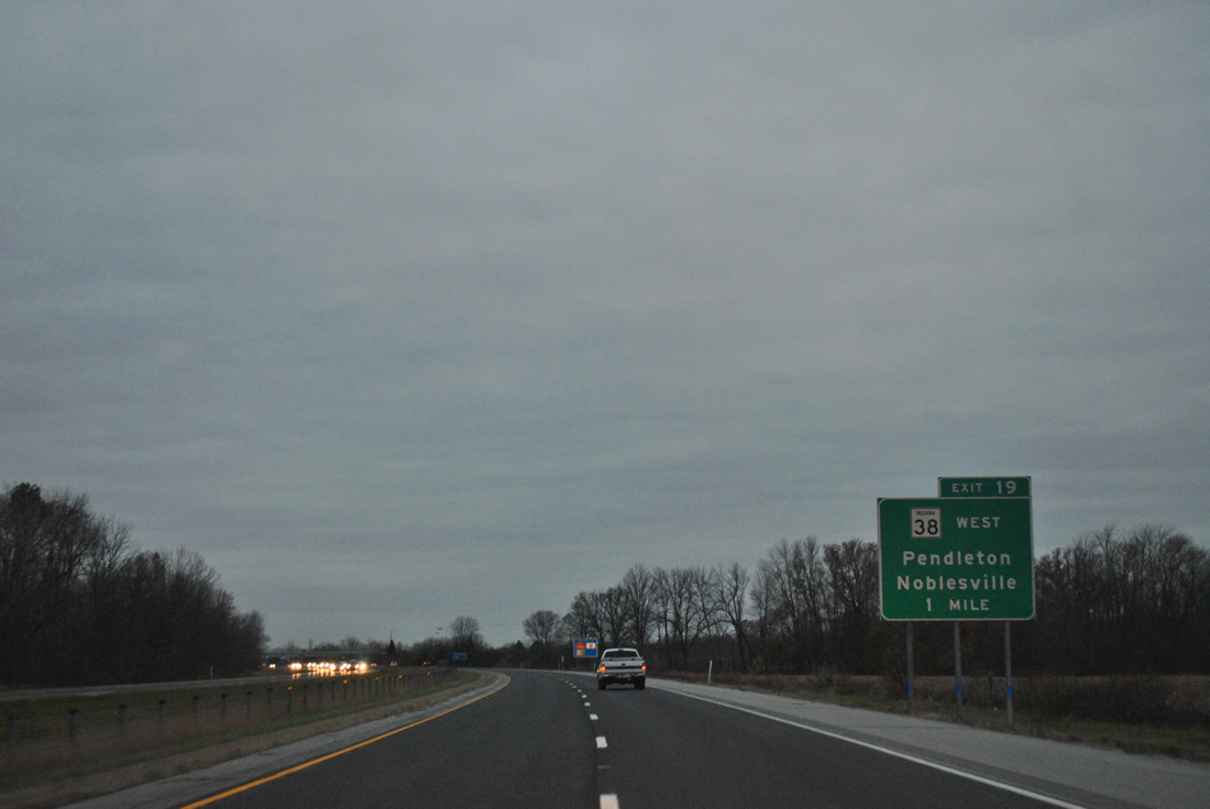
| SR 38 follows Interstate 69 around the north side of Pendleton. SR 38 goes for 116.4 miles from U.S. 52 in Lafayette east through Frankfort, Noblesville, Pendleton and New Castle before ending at U.S. 35 near Richmond. 11/06/11 |
|
| Pendleton, accessed via Exit 219 and State Street east, is four miles away. Fortville is the next community at 14 miles. Indianapolis is 35 miles away. 11/06/11 |
|
| SR 38 goes to the west for 15 miles back to Noblesville via the community of Clarksville. 11/06/11 |
|
| SR 38 used to continue east through the town of Pendleton via State Street, but that stretch was decommissioned from Interstate 69 to U.S. 36, SR 9 & SR 67 east of town. This decommissioning, done in 2004, severed the highway for a year until it was rerouted along Interstate 69 and U.S. 36, SR 9 & SR 67 to bypass Pendleton. 11/06/11 |
|
| Exit 219 leaves Interstate 69 for SR 38 west and State Street. The town of Pendleton is less than a mile to the east from Exit 219. 11/06/11 |
|
| South of Exit 219, Fortville is now eight miles away. Interstate 465 is 18 miles to the south and Indianapolis is 29 miles. Notice how the difference of mileage between Interstate 465 and Indianapolis is ten miles. 02/06/12 |
|
| Up ahead is Exit 214 with SR 13, which goes for 138 miles from U.S. 36/SR 67 in Fortville north through Elwood, Wabash and Syracuse before ending at the Indiana Toll Road (I-80/90) north of Middlebury. 02/06/12 |
|
| At the half mile approach to Exit 214 with SR 13. Lapel is located four miles to the north at the junction of SR 13 with SR 32. 02/06/12 |
|
| Exit 214 departs Interstate 69 onto SR 13. Fortville is six miles to the south at the southern end of SR 13 at U.S. 36/SR 67. 02/06/12 |
|
| West of Exit 214, Noblesville is ten miles away. Interstate 465 and Indianapolis are 13 and 25 miles away. Note how the difference between the last two control points is now 12 miles. 02/06/12 |
|
| West of Exit 214, Interstate 69 enters Hamilton County. 02/06/12 |
|
| An auxiliary guide sign directs travelers to the eastern parts of Fishers and Noblesville via Exit 210 up ahead. 02/06/12 |
|
| Interstate 69 is now a mile away from Exit 210, a diamond interchange that serves Campus Parkway and Southeastern Parkway. Until 2011, the exit served SR 238, which traveled southeast from Interstate 69 for six miles to SR 13 in Fortville. The highway has since been decommissioned and returned to local authorities. At one time, the highway stretched from SR 37 in Noblesville, to the southeast, to Greenfield. 02/06/12 |
|
| Campus Parkway goes across the Saxony Campus past the Hamilton Town Center lifestyle center to the northwest to connect with 146th Street, a four lane arterial that heads west across northern Fishers, southern Noblesville and the cities of Westfield and Carmel. The name Campus Parkway continues northwest to Marilyn Road, where it becomes 146th Street. The Verizon Wireless Music Center can be reached by taking Campus Parkway west from Exit 210 to Bergen Boulevard and north to 146th Street. 02/06/12 |
|
| Exit 210 turns off of Interstate 69 onto Campus Parkway and Southeastern Parkway. Southeastern Parkway continues to the southeast and follows the old routing of SR 238 to Fortville, connecting with Olio Road, a major north-south road across eastern Hamilton County that continues to the south as Mount Comfort Road (County Road 600 West), connecting with Interstate 70 in western Hancock County. 02/06/12 |
|
| The central part of the town of Fishers is five miles away, even though the growing suburb already surrounds the interstate from Exit 210 westward. Interstate 465 and Indianapolis are now separated by eleven miles at a distance of nine and 20 miles respectively. 02/06/12 |
|
| A new travel time sign announces to motorists the distance and current travel time to 96th Street (Exit 205) and Interstate 465 (Exit 200). Note on the side a 2/10ths mile marker that was placed in early 2012. These mile markers stretch from before Exit 226 in Anderson westward toward Interstate 465. 02/06/12 |
|
| Interstate 69 is now one mile away from Exit 205, serving 116th Street. 02/06/12 |
|
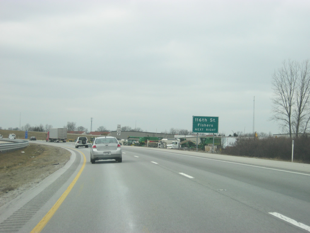
| 116th Street is a major east-west road across the communities of Carmel and Fishers. The highway begins as an extension of Oak Street in Zionsville and crosses Carmel and over the White River into Fishers. In Fishers, 116th Street is a four lane boulevard east across I-69/SR 37 north and east to Olio Road. 02/06/12 |
|
| The Conner Prairie Living History Museum and the Hamilton County Visitors Center can be reached by taking 116th Street to the west into Fishers from Exit 205. 02/06/12 |
|
| We are now only a quarter mile away from Exit 205 to 116th Street. Those wanting to head north on SR 37 toward Noblesville will have to get off at 116th Street and head east across the highway and turn around back toward the north. 02/06/12 |
|
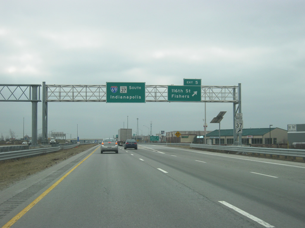
| Exit 205 turns off of southbound Interstate 69 onto a collector distributor roadway that carries traffic from southbound SR 37 onto Interstate 69. Currently, traffic must switch lanes to the right while SR 37 southbound traffic switches lanes to the left of the collector distributor setup. In 2012, the interchange complex at Exit 205 will get rebuilt and the weaving will be eliminated. Southbound SR 37 traffic will be routed straight onto Interstate 69 while traffic heading to 116th Street. For more information on Operation Indy Commute see http://www.in.gov/indot/2381.htm. 02/06/12 |
|
| SR 37 goes for 218 miles from Marion south through Noblesville, Indianapolis, Martinsville, Bloomington, Bedford and Paoli en route to its southern terminus at Tell City. A second segment exists northeast of Interstate 469. The state highway follows Interstate 69 south to its southern terminus. 02/06/12 |
|
| 96th Street straddles the Marion County line and meets I-69/SR 37 at the Exit 203 diamond interchange. 02/06/12 |
|
| A dynamic message sign straddles I-69/SR 37 south at the 106th Street overpass. In 2013, the interstate will be widened to four lanes to the south just as the northbound lanes were widened in 2008. Auxiliary lanes will be placed to the right in between exits. 02/06/12 |
|
| 96th Street serves an area of business parks and shopping centers that surround Exit 203. Strip malls, big box retail and hotels, and fast food franchises line the arterial in both directions. 02/06/12 |
|
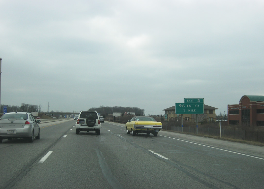
| Exit 203 leaves I-69/SR 37 north, 2.25 miles south of their merge. 96th Street heads west to Indianapolis Metropolitan Airport and east to Fall Creek Road at Geist Reservoir. The final two exits on Interstate 69 are listed. 02/06/12 |
|
| I-69/SR 37 enter Marion County and see two interchanges before the current southern terminus. This photo looks at the final mainline reassurance shield. 10/16/04 |
|
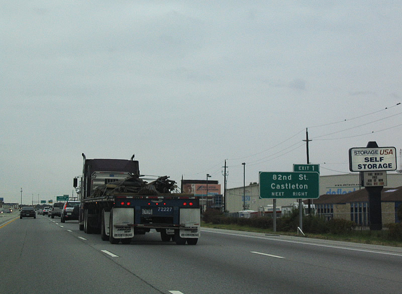
| 82nd Street meets I-69/SR 37 at Castleton and Shadeland Avenue. SR 100 once traveled 82nd Street east from Allisonville to Shadeland Avenue south before Interstate 465 opened. 10/16/04 |
|
| Exit 201 constitutes a folded diamond interchange with East 82nd Street. 82nd Street ventures west to Castleton Square mall along a commercial strip between Interstate 69 and Keystone Avenue (former SR 431). 10/16/04 |
|
| I-69/SR 37 expands to four overall lanes ahead of the directional cloverleaf interchange (Exit 200) with I-465. SR 37 joins the beltway southward between Exit 37 here and Exit 4. SR 37 represents the future I-69 corridor leading south from Indianapolis to Martinsville. 02/06/12 |
|
| Exit 200 carries all traffic bound for Interstate 465 in unison from Interstate 69 south. Interstate 465 heads south to Lawrence, Warren Park, and Five Points (Interstate 74 east) and west to Allisonville, the Carmel area, and Interstate 865 west to Interstate 65 north at Royalton. The ramp was reconfigured so that the middle two lanes would feed onto Interstate 465 south while the right two lanes head onto Interstate 465 west and the left two lanes continue south onto Binford Boulevard. 02/06/12 |
|
| Now at the split with Interstate 465 south and west. Both ramps carry two lanes while the original interchange had two lanes for Interstate 465 south and one lane for Interstate 465 west. Interstate 465 carries U.S. 31-52-421 through the interchange with Interstate 65. None of the shared routes are signed however. 02/06/12 |
|
| Continuing south, Interstate 69 defaults onto Binford Boulevard, a former alignment of SR 37 south to Fall Creek Parkway and 38th Street (former U.S. 36/SR 67). 10/16/04 |
|
| The freeway ends at a traffic light with 75th Street and the transition into Binford Boulevard. 75th Street leads east to Shadeland Avenue (former SR 100) and west to Allisonville Road (old SR 37A). 10/16/04 |
Page Updated 02-29-2012.