|
| I-70/U.S. 35 north enter the Hoosier State of Indiana at Exit 156 A-B. To the immediate right, Exit 156 B takes travelers east along U.S. 40 back into Ohio toward the town of Lewisburg, along with New Paris (via SR 320). Exit 156 A toward U.S. 40 west (National Road) into the Wayne County seat of Richmond is a fourth of a mile away. 02/29/12 |
|
| A Welcome to Indiana sign greets motorists along I-70/U.S. 35 north within the parclo interchange at Exit 156 A-B. 02/29/12 |
|
| Exit 156 A departs I-70/U.S. 35 north via a loop ramp onto U.S. 40 west (National Road). U.S. 40 leads west across a commercialized stretch of National Road on the east side of Richmond. Interstate 70 follows the US highway across Indiana and remains to the north of it from this point until Indianapolis. 02/29/12 |
|
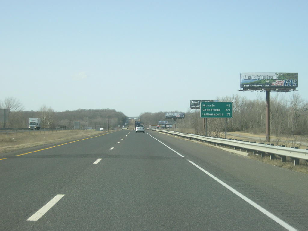
| The first highway shields for both Interstate 70 and U.S. 35 north greet motorists north of Exit 156 A-B. U.S. 35 joins Interstate 70 at Exit 1 in Ohio and will follow Interstate 70 around the north side of Richmond to Exit 149 A. In the past, U.S. 35 was routed through Richmond along National Road across town to Williamsburg Pike, and north along Williamsburg Pike to the current U.S. 35. 02/29/12 |
|
| The Delaware County seat of Muncie (via U.S. 35 north) is 41 miles away. Greenfield, the county seat of Hancock County, is 49 miles away along Interstate 70 and the Indiana capital city of Indianapolis is 71 miles away. 02/29/12 |
|
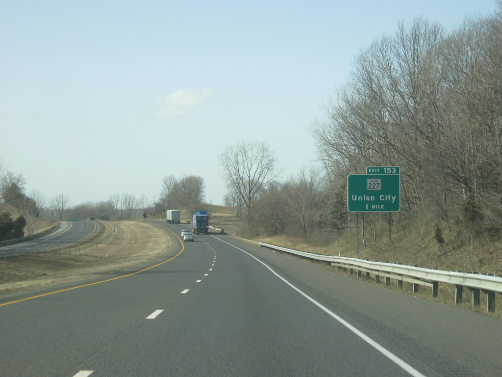
| SR 227 meets I-70/U.S. 35 north at Exit 153 in one mile. 02/29/12 |
|
| SR 227 goes for 37 miles from the junction with SR 117 in Union County and north through Richmond via U.S. 27 before heading northeast in the direction of Union City in eastern Randolph County, where it ends at the junction with SR 32. 02/29/12 |
|
| Exit 153 departs I-70/U.S. 35 north at a folded diamond interchange with SR 227. To the south, SR 227 follows Middlesboro Pike to the southeast to the junction with SR 121 and U.S. 27 near downtown Richmond. SR 227 multiplexes with its parent U.S. 27 across Richmond and breaks away to the southeast outside town. 02/29/12 |
|
| Chester Boulevard, which is also U.S. 27, is one mile away at Exit 151. Chester Boulevard consists of a newly rebuilt four lane highway from the town of Chester one mile to the north of Exit 151 southward a couple of miles into downtown Richmond. This includes a new single-point urban interchange with I-70/U.S. 35 north. 02/29/12 |
|
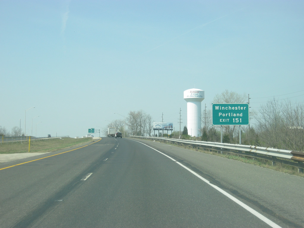
| U.S. 27 goes for 117.78 miles across Indiana from southeast of Liberty through the city of Richmond and north toward Fort Wayne where it ends at Interstate 69/SR 3. Nationally, the highway goes for 1,373 miles from Fort Wayne south through Richmond toward Cincinnati and the highway’s southern terminus at Miami, Florida. 02/29/12 |
|
| The Richmond Municipal Airport, Ivy Tech Community College and Indiana University-East are all reached via Exit 151. The Randolph County seat of Winchester and Jay County seat of Portland are 25 and 42 miles away to the north along U.S. 27. 02/29/12 |
|
| Exit 151 departs I-70/U.S. 35 south at a single-point urban interchange with U.S. 27 (Chester Boulevard). The interchange replaced an older parclo interchange in 2008. The previous interchange had loop ramps in the northeast and southeast quadrants and was built in 1958 when Interstate 70 was built across the north side of Richmond. 02/29/12 |
|
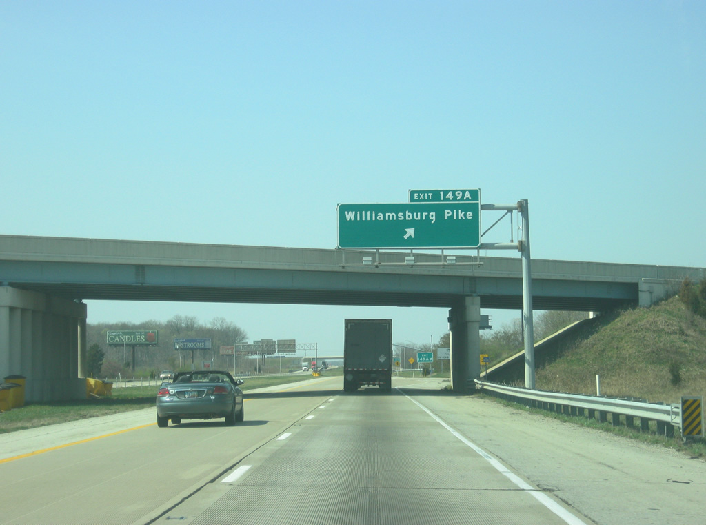
| Interstate 70 is one mile away from Exit 149 A-B which is where U.S. 35 north will split toward the northwest. U.S. 35 runs for 210 miles across Indiana from Michigan City to the north through LaPorte, Logansport, Kokomo, Gas City, Muncie and Richmond. SR 38 begins a half mile north of the interchange and travels for 116.4 miles through the communities of New Castle, Pendleton, Noblesville and Frankfort before ending at U.S. 52 in Lafayette. 02/29/12 |
|
| Williamsburg Pike consists of the former routing of U.S. 35 to the south into the city of Richmond to a junction with U.S. 40 (National Road). Earlham College, a liberal arts college founded in 1847 by Quakers, is located south in the city of Richmond off of Exit 149A. 02/29/12 |
|
| U.S. 35 north departs Interstate 70 at Exit 149 A en route for the 40 mile journey to Muncie. A weigh station for truckers heading west into Indiana is one mile away. 02/29/12 |
|
| Exit 149 B consists of a loop ramp toward the south along Williamsburg Pike toward the west side of Richmond. 02/29/12 |
|
| West of Exit 149 A-B (U.S. 35 north/Williamsburg Pike) the right lane becomes an exit ramp onto the weigh station (closed at the time of the pictures). 02/29/12 |
|
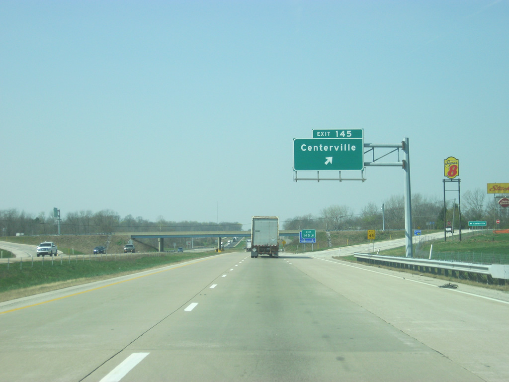
| West of the weigh station, the first Interstate 70 shield by itself greets motorists, along with the distances to the Wayne County town of Centerville (six miles), Greenfield (42 miles) and Indianapolis (64 miles). 02/29/12 |
|
| Centerville Road meets Interstate 70 at a diamond interchange at Exit 145. 02/29/12 |
|
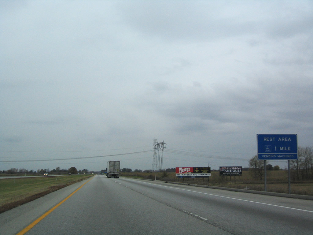
| Near the half mile approach to Exit 145 (Centerville Road), Interstate 70 is two miles away from the Centerville Welcome Center. The next rest area serving westbound Interstate 70 motorist is 42 miles away near Greenfield. 02/29/12 |
|
| Exit 145 turns off of Interstate 70 for Centerville Road, which heads south to the town of Centerville at U.S. 40. To the north, the road connects with U.S. 35 at Williamsburg. 02/29/12 |
|
| Passing underneath Centerville Road, the Centerville Welcome Center is now a mile away. The welcome center was rebuilt in 2011 from a former rest area (not a welcome center however) that existed in the same location. 02/29/12 |
|
| West of Exit 145 (Centerville Road), Exit 137 (at SR 1) is eight miles away. Greenfield and Indianapolis are 39 and 61 miles away respectively. 02/29/12 |
|
| Westbound at the off-ramp into the Centerville Welcome Center. An eastbound rest area used to serve eastbound travelers across from the former Centerville Rest Area, but that has since been abandoned due to its proximity to the Ohio welcome center. 02/29/12 |
|
| West of the Centerville Welcome Center, the Fayette County seat of Connersville is 21 miles away via SR 1 south. Interestingly, despite having moved closer to Indianapolis, the distance to the Hoosier capital has gone up by two miles since the previous distance sign (161 to 163 miles). 02/29/12 |
|
| Interstate 70 enters the flat till plains of Central Indiana west of the Richmond area and the terrain will remain nearly the same for the distance to Indianapolis (with an exception or two). 02/29/12 |
|
| Crossing paths with Interstate 70 next is SR 1, a two-segment route stretching 139.8 miles from Lawrenceburg to Fort Wayne and for 40.7 miles between Fort Wayne and Ellis. 02/29/12 |
|
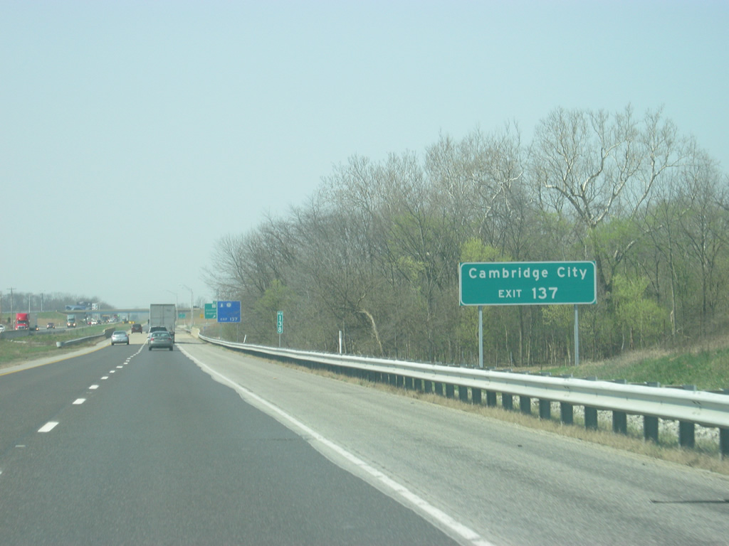
| SR 1 connects Interstate 70 with the Wayne County town of Hagerstown four miles to the north and with Connersville 15 miles to the south. Cambridge City, a historic National Road town along U.S. 40 is two miles to the south from Exit 137. 02/29/12 |
|
| Exit 137 departs Interstate 70 at a diamond interchange with SR 1. 02/29/12 |
|
| Past Exit 137 (SR 1), Interstate 70 is six miles from the Henry County community of New Lisbon and 52 miles from Indianapolis. 02/29/12 |
|
| Interstate 70 crosses into Henry County a couple of miles east of Exit 131. 02/29/12 |
|
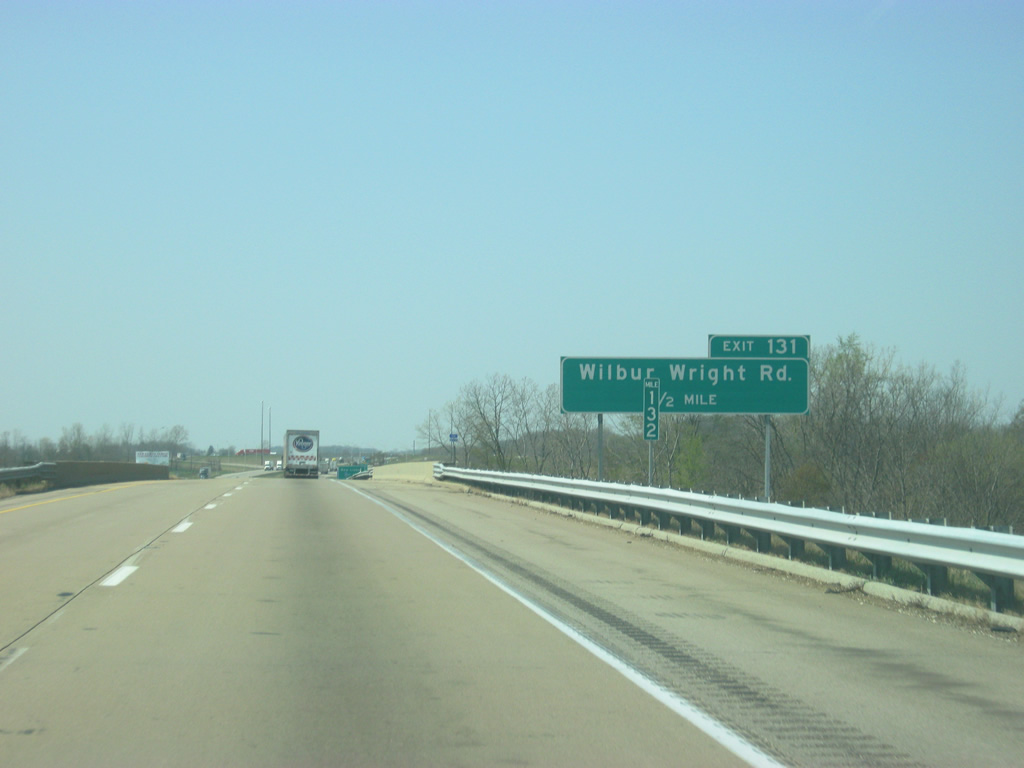
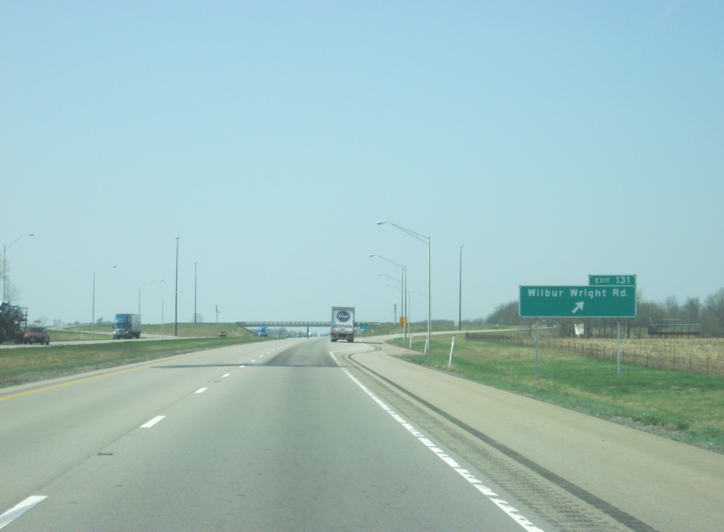
| Now a mile away from Exit 131 with Wilbur Wright Road in eastern Henry County. 02/29/12 |
|
| Wilbur Wright Road heads north less than a mile to the town of New Lisbon and continues from there on a zigzagging route to the town of Millville. Millville is the birthplace of Wilbur Wright, one of the two famous Wright Brothers of aviation fame. 02/29/12 |
|
| Exit 131 departs Interstate 70 at the diamond interchange with Wilbur Wright Road. To the south, Wilbur Wright Road connects with U.S. 40 east of the town of Straughn. To the north of New Lisbon, Dublin Pike connects with the Henry County seat of New Castle. 02/29/12 |
|
| The communities of Spiceland (nine miles) and New Castle (14 miles) are both served by the next interchange along Interstate 70. Indianapolis is 46 miles away. 02/29/12 |
|
| View of Interstate 70 as it traverses southern Henry County en route to Exit 123 (SR 3). U.S. 40, the historic National Road, follows only a few miles to the south along an identical, but parallel path from Richmond to Indianapolis. 02/29/12 |
|
| SR 3 meets Interstate 70 at a folded diamond interchange for Exit 123. SR 3 exists for 178.8 miles from Charlestown to Fort Wayne and again for 44.8 miles from Fort Wayne to Brighton. 02/29/12 |
|
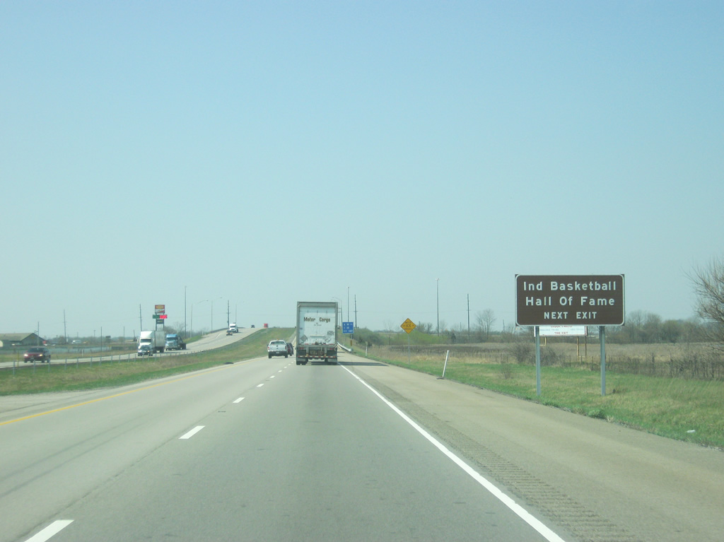
| SR 3 consists of a four lane expressway north for seven miles into New Castle and around 30 miles to the Delaware County seat of Muncie. The Indiana Basketball Hall of Fame, honoring the Hoosier State's greatest sport, is located north off of SR 3 in New Castle. 02/29/12 |
|
| Heading west from the folded diamond interchange with SR 3 (Exit 123) near Spiceland on Interstate 70. 10/16/04 |
|
| SR 3 consists of a four lane expressway north for seven miles into New Castle and around 30 miles to the Delaware County seat of Muncie. The Indiana Basketball Hall of Fame, honoring the Hoosier State's greatest sport, is located north off of SR 3 in New Castle. 02/29/12 |
|
| A wide roadway includes a stand of trees along Interstate 70 north of Spiceland. Old Spiceland Road passes under the freeway ahead of the next ridge. 10/16/04 |
|
| Exit 123 exits off of Interstate 70 onto SR 3. To the south, SR 3 goes into Spiceland before meeting up with U.S. 40 in Dunreith. From there, it's a 14 mile journey to the Rush County seat of Rushville. 02/29/12 |
|
| The final Henry County interchange of Interstate 70 west joins the freeway with SR 109 north of Knightstown. 10/16/04 |
|
| A parclo interchange facilitates the movements between Interstate 70 and SR 109 at Exit 115. SR 109 exists in two portions, the southern section here travels between Knightstown (U.S. 40) to Anderson (Interstate 69) for a distance of 21.8 miles. 10/16/04 |
|
| Continuing west, Interstate 70 approaches the Greenfield area (Exit 104) on the 30 mile drive to Indianapolis. 10/16/04 |
|
| Modern rest areas lie on both sides of Interstate 70 west of the Hancock line. An original westbound only facility was abandoned midway between Exit 115 and the Henry County line. The original eastbound facility was replaced with the current area. 10/16/04 |
|
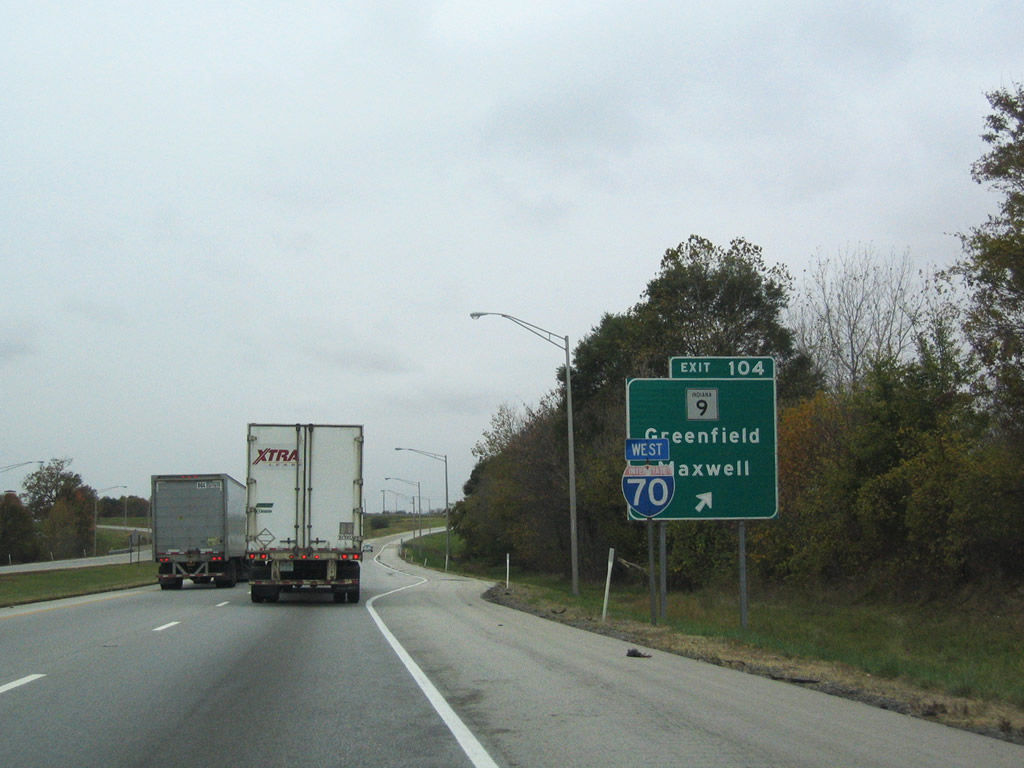
| SR 9 (North State Street) interchanges with Interstate 70 on the north side of Greenfield. The state road constitutes a 196 mile route between the Michigan line and SR 46 east of Columbus. 10/16/04 |
|
| Exit 104 comprises a diamond interchange with SR 9 (North State Street) 2.5 miles south of Maxwell and 2.5 miles north of U.S. 40 (Main Street) and downtown Greenfield. 10/16/04 |
|
| Westbound Interstate 70 at Exit 104 to SR 9 (North State Street). SR 9 merges with SR 67 seven miles northward at Pendleton and heads 19 miles south to Interstate 74 at Shelbyville. 10/16/04 |
|
| Interstate 70 shield posted between Exits 104 and the Fortville Pike Road overpass outside Greenfield. 10/16/04 |
|
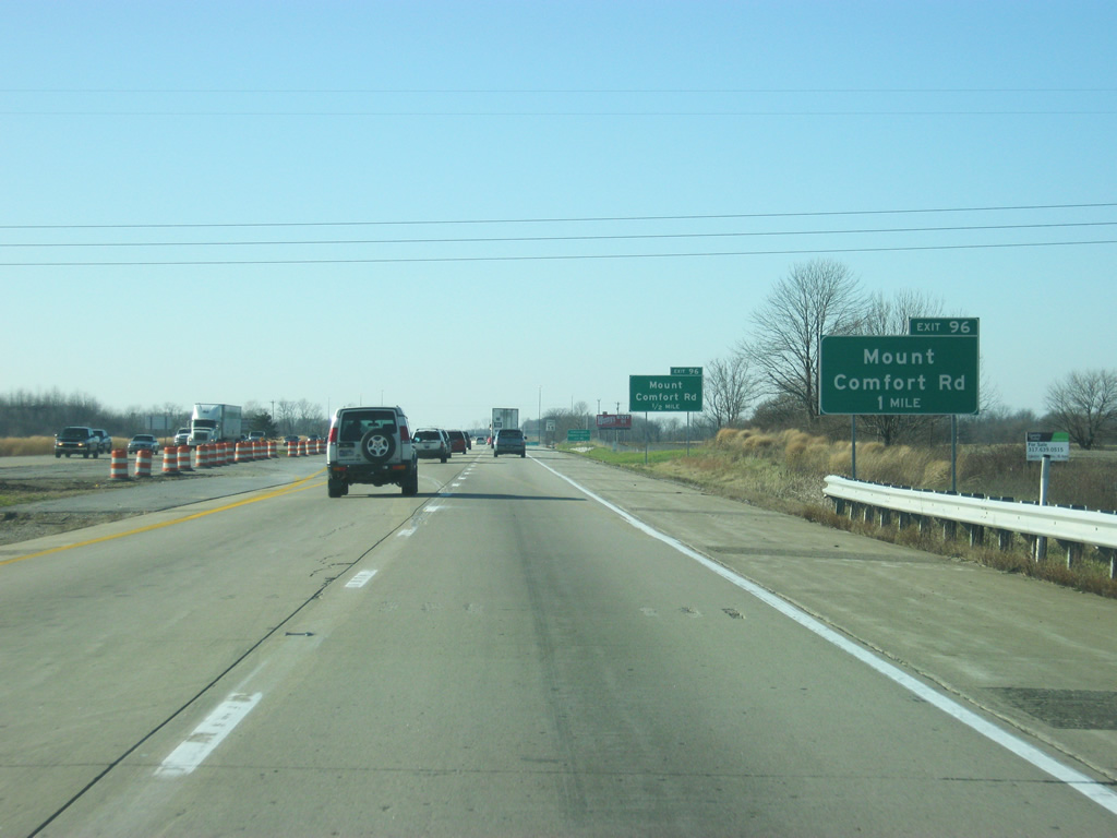
| The next westbound interchange lies ten miles ahead with North County Road 600 West near Mount Comfort. Interstate 465 follows in 13 miles. Indianapolis is 21 miles away. 12/17/11 |
|
| Interstate 70 west of Exit 104 (SR 9) is a fairly busy highway at peak hours with traffic from Greenfield and suburban Hancock County utilizing it toward Indianapolis. Future plans call for Interstate 70 to be widened to six lanes from Post Road (Exit 91) to SR 9 (Exit 104). As of 2012, the stretch up to Mount Comfort Road (Exit 96) was widened to six lanes. 12/17/11 |
|
| Interstate 70 is now one mile away from the Exit 96 parclo interchange with Mount Comfort Road, (also known as County Road 600 West). The interchange is less than a mile south of the town of Mount Comfort. 12/17/11 |
|
| The Indianapolis Regional Airport (formerly Mount Comfort Airport) can be reached by taking County Road 600 West north of Exit 96. 12/17/11 |
|
| Exit 96 departs Interstate 70 at the new parclo interchange with Mount Comfort Road (County Road 600 West). Mount Comfort Road heads north through the town of Mount Comfort and McCordsville (located along U.S. 36/SR 67). The road continues north as Olio Road which leads to Exit 10 off of Interstate 69. To the south, the road intersects with U.S. 40 around Gem and continues south to New Palestine at U.S. 52. 12/17/11 |
|
| Exit 96 (Mount Comfort Road) was changed from a diamond interchange to a parclo interchange due to the suburban growth of western Hancock County, as it is the only exit from SR 9 to Post Road. 12/17/11 |
|
| West of Exit 96 (Mount Comfort Road), Interstate 465 is six miles away and Downtown Indianapolis is 14 miles away. In 2012, construction will be finished that will expand Interstate 70 to six lanes from Exit 96 to Exit 91 (Post Road). 12/17/11 |
Page Updated 08-08-2012.

 West
West  North
North