|
| The lower deck of the Brent Spence Bridge carries I-71/75 north with four overall lanes to a directional T interchange with Fort Washington Way. The bridge was restriped to add a lane in place of the shoulder in 1986. 11/08/09 |
|
| Emerging from the lower deck of the Brent Spence Bridge, I-71 north turns east to combine with U.S. 50 along Fort Washington Way via Exit 1B. U.S. 50 west follows the 6th Street Expressway from nearby Exit 1D through the Queensgate industrial area along the Ohio River. 11/08/09 |
|
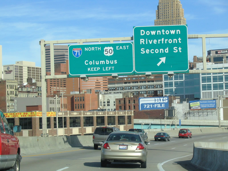
| The two lane flyover for Interstate 71 (Fort Washington Way) north quickly partitions with the unnumbered exit to Second Street for the Downtown Riverfront. This is the lone exit for the central business district from I-71 north. 11/14/04 |
|
| Cincinnati's skyline rises along the northern side of Interstate 71 as U.S. 50 merges from I-75 to the left. Fort Washington Way lowers to run between parallel 2nd and 3rd Streets from adjacent Paul Brown Stadium east to Great American Ballpark. 11/14/04 |
|
| U.S. 50 and Interstate 71 overlap for just a half mile as the US highway quickly parts ways toward Columbia Parkway. The continuation of Fort Washington Way also provides the connection to Interstate 471 south to Newport and Bellevue. 11/14/04 |
|
| A cable-stayed pedestrian bridge spans Interstate 71 & U.S. 50 at Elm Street to the northeast of Paul Brown Stadium. 11/14/04 |
|
| Interstate 471 joins Downtown Cincinnati with Southgate, Fort Thomas and U.S. 27 at Highland Heights, Kentucky. The freeway spans the Ohio River on the Dan Beard Bridge, a yellow-painted tied arch bridge. 11/14/04 |
|
| U.S. 50 (Fort Washington Way) continues a short distance beyond the split with I-71 north to Interstate 471 south. There U.S. 50 transitions onto Columbia Parkway to parallel US. 52 (Riverside Drive) east to Mount Adams, East Walnut Hills and the East End neighborhoods of Cincinnati. 11/14/04 |
|
| Interstate 71 splits with Fort Washington Way (U.S. 50) at an unnumbered wye interchange north of Great American Ball Park. 11/14/04 |
|
| Traveling along the sharp curve from Fort Washington Way, U.S. Bank Arena, an indoor concert and sports arena, comes into view between I-71 and the Taylor Southgate Bridge (U.S. 27). 11/14/04 |
|
| Two lanes of Interstate 71 veer northward below Fort Washington Way toward the Lytle Tunnel and the north end of I-471. 11/14/04 |
|
| Lytle Tunnel passes below Lytle Park, an apartment building and portions of 4th, 5th and Pike Streets. The nearly 1,100 tunnel was completed in 1969. 11/14/04 |
|
| The on-ramp from 2nd Street adds a third northbound lane for Interstate 71 through Lytle Tunnel. 11/14/04 |
|
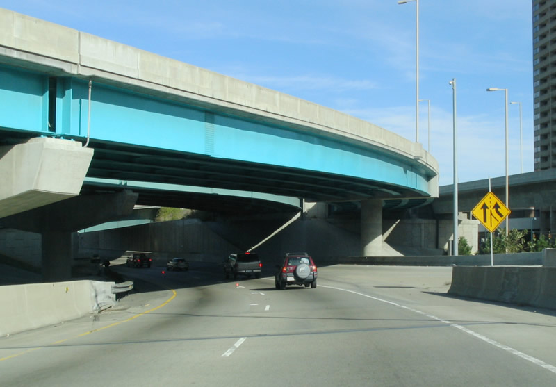
| Interstate 71 emerges from the tunnel and ascends onto a viaduct above parking lots and Eggleston Avenue. A wye interchange brings the north end of Interstate 471 onto I-71, a half mile ahead of Exit 2 for U.S. 42 (Reading Road). U.S. 42 follows Reading Road northward from Central Parkway in Downtown to the Mt. Auburn and Avondale neighborhoods. Eden Park Drive links U.S. 42 with U.S. 22 & SR 3 (Gilbert Avenue) at Eden Park. 11/14/04 |
|
| A series of ramps and a pedestrian overpass cross Interstate 71 ahead of the left side ramp (Exit 2) to U.S. 42 and Eden Park Drive. U.S. 42 continues north through the Bond Hill and Roselawn communities to Reading and Sharonville midway between the I-71 and I-75 corridors. The US highway will not meet Interstate 71 directly again until Exit 234 at Middleburg Heights. 11/04/11 |
|
| Interlaced wye interchanges connect Interstate 71 with U.S. 42 (Reading Road) as the route separates into a couplet between Elsinore Place and Dorchester Avenue by the Walnut Hills neighborhood. 11/04/11 |
|
| Exit 2 partitions into its ramps for Eden Park Road east / Dorchester Avenue west and U.S. 42 (Reading Road) north between the roadways of I-71. Florence Avenue stems northeast from the ramp end to U.S. 22 & SR 3 (Gilbert Avenue). 06/04/08 |
|
| Interstate 71 travels below grade through the Walnut Hills and Avondale communities to Victory Parkway. 11/04/11 |
|
| McMillan Street passes over the nine lane freeway. A northbound on-ramp follows. 11/04/11 |
|
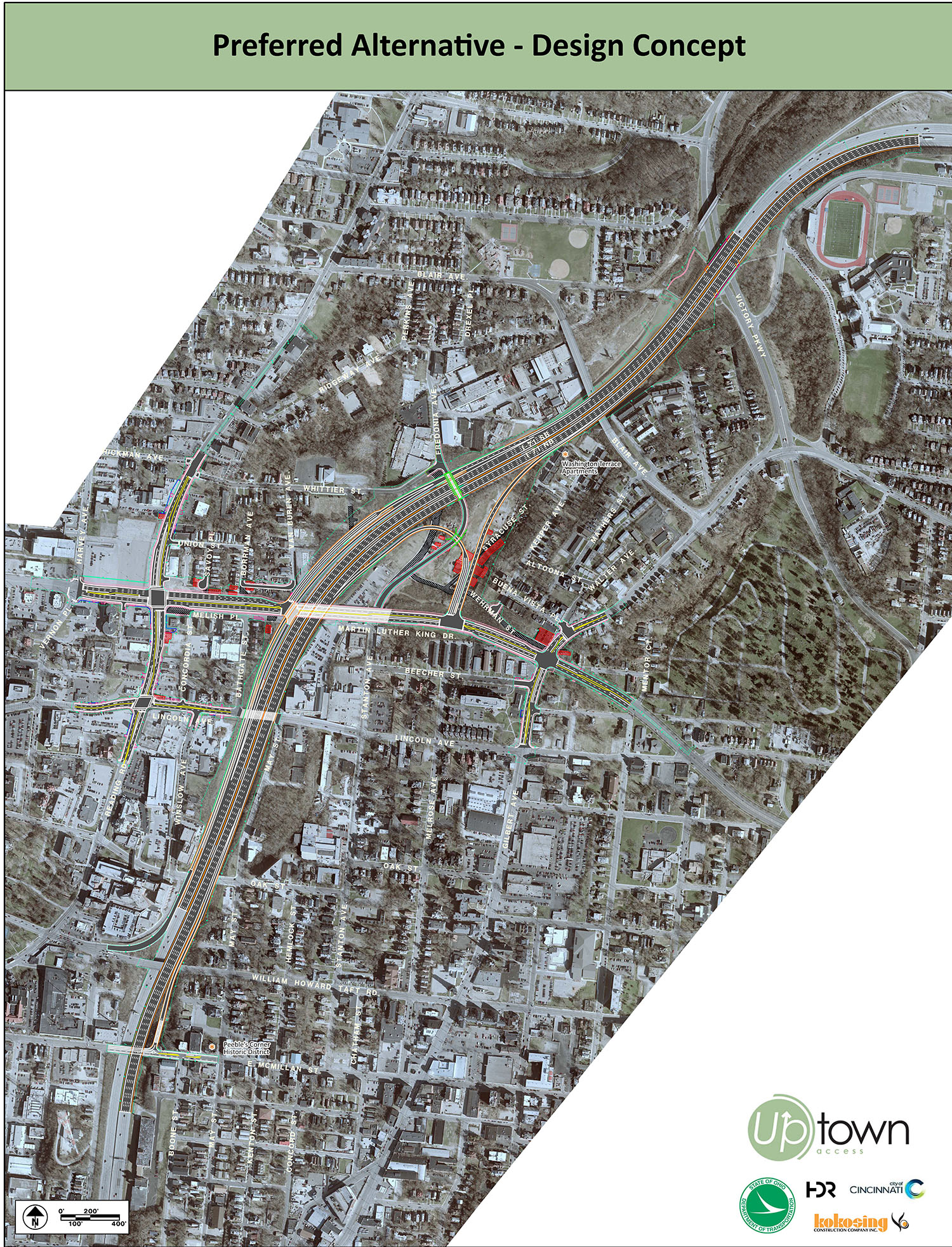
| Construction underway from the Oak Street overpass northward adds a new parclo interchange to Interstate 71 with Martin Luther King Drive. The fall 2016 opened exit provides better access to the University of Cincinnati and Cincinnati Zoo. 11/04/11 |
|
| What was the first reassurance marker for Interstate 71 north stood ahead of the Lincoln Avenue overpass. The MLK Interchange project by ODOT included widening of MLK Drive and replacing Fredonia Avenue with an extension of Stanton Avenue.2 11/04/11 |
|
| Interstate 71 curves east through the Evanston community to Exit 5 for Dana Avenue and Montgomery Road. Exit 5 joins the freeway with parallel Duck Creek Road, midway between its intersections with U.S. 22 & SR 3 (Montgomery Road) and Dana Avenue. 11/04/11 |
|
| Attached to the Woodburn Avenue overpass is this approach guide sign for Exit 5. Dana Avenue leads west from U.S. 22 & SR 3 (Montgomery Road) to Xavier University and south to Hyde Park. 11/04/11 |
|
| Exit 5 departs Interstate 71 north for adjacent Duck Creek Road. U.S. 22 & SR 3 (Montgomery Road) continue north from Duck Creek Road into the city of Norwood and south back to Walnut Hills. 11/04/11 |
|
| The succeeding exit of I-71 north joins the freeway with SR 561 at a split diamond interchange with Smith Road and Williams Avenue at the Rookwood Commons retail area. 11/04/11 |
|
| SR 561 follows Edwards Road south from Edmondson Avenue and Exit 6 through Hyde Park to Observatory Avenue. The state route ends a 7.3 mile route at U.S. 50 in the Mt. Lookout community. 11/04/11 |
|
| Northbound Interstate 71 reaches the ramp departure (Exit 6) to Smith Road north and Edmondson Road east. SR 561 bisects Norwood northward to reenter Cincinnati between the Bond Hill and Roselawn neighborhoods. 11/04/11 |
|
| SR 562 (Norwood Lateral) and Interstate 71 come together at a directional cloverleaf (Exits 8A/B) east of Norwood. The state route follows an east-west freeway linking I-71 and Norwood with Interstate 75 at St. Bernard. 11/04/11 |
|
| Confirming marker for I-71 north posted as the freeway straddles the Norwood city line west of the Oakley Station big box retail center. 11/04/11 |
|
| SR 562 west parallels a railroad corridor across Norwood on a 3.43 mile route to Interstate 75 by the village of St. Bernard. 11/04/11 |
|
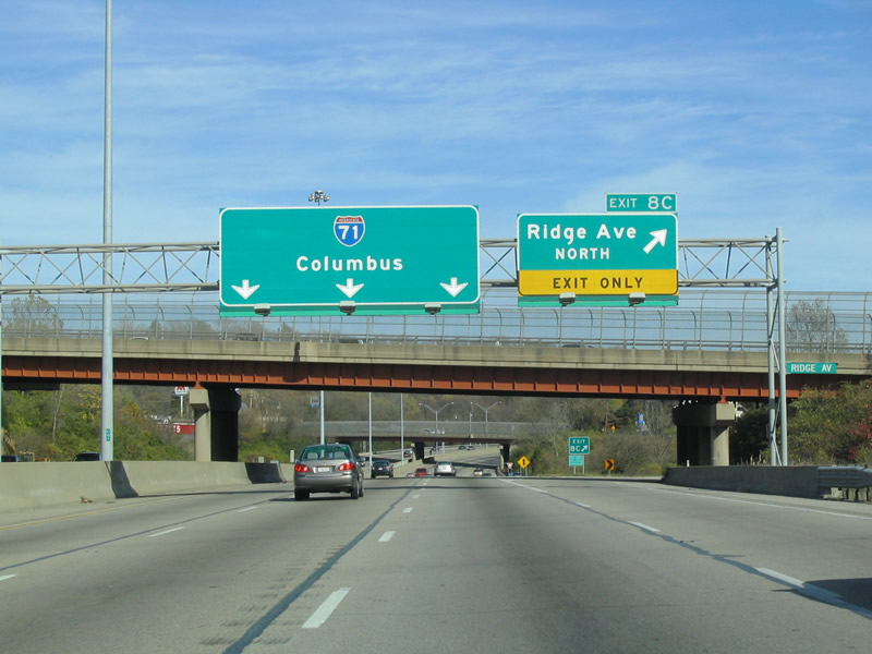
| Curving eastward again, I-71 intertwines with the eastern extent of the Norwood Lateral to reenter Cincinnati. Exit 8A connects with the freeway east to the Center of Cincinnati retail center and Ridge Avenue at the Oakley neighborhood. 11/04/11 |
|
| Exit 8A partitions with I-71 north to join the Norwood Lateral east to Ridge Avenue south. A loop ramp (Exit 8C) joins Interstate 71 north with Ridge Avenue north directly beyond the westbound exit for SR 562. 11/04/11 |
|
| A left side on-ramp adds motorists from SR 562 eastbound opposite the loop ramp (Exit 8B) for the Norwood Lateral west. SR 562 west to Interstate 75 north leads drivers to Carthage in north Cincinnati and south to the Clifton neighborhood. 11/04/11 |
|
| Ridge Avenue serves a number of big box retail stores just north of Exit 8C en route to the Pleasant Ridge neighborhood. 11/14/04 |
|
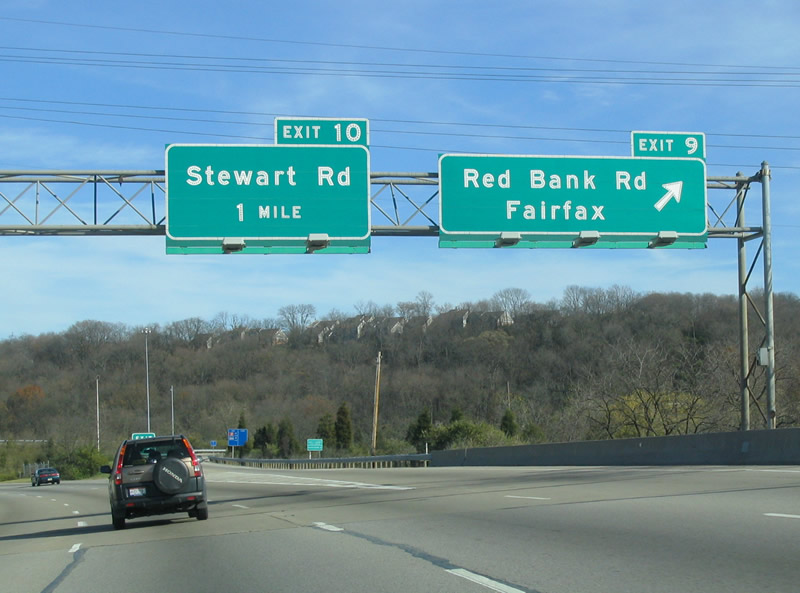
| Interstate 71 leaves the city of Cincinnati through a swath of unincorporated Hamilton County. A semi directional T interchange (Exit 9) follows with Red Bank Expressway south to Madisonville in east Cincinnati. 11/14/04 |
|
| Red Bank Road passes under Interstate 71 as Exit 9 departs for Red Bank Expressway south. Red Bank Road / Expressway travels south to U.S. 50 in the village of Fairfax. Despite the Expressway name, the road travels at-grade with signalized intersections. 11/14/04 |
|
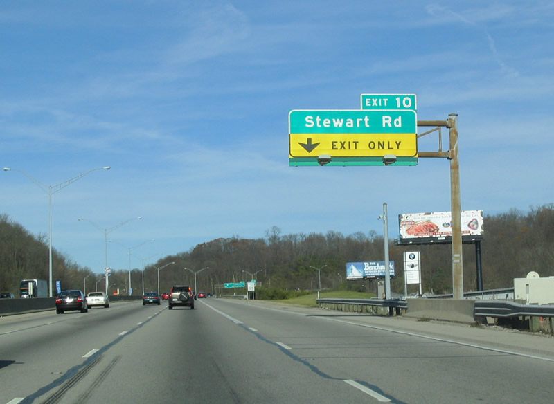
| I-71 turns north from Red Bank Expressway toward Stewart Road and Exit 10. Stewart Road heads north from Madison Road in Madisonville alongside Interstate 71 to the village of Silverton. 11/14/04 |
|
| The Red Bank Expressway exchange resides in a valley between Daniel Drake Park and an 860 foot hill to the east. 11/14/04 |
|
| An auxiliary lane opens northbound from the Red Bank Expressway to the loop ramp (Exit 9) for Stewart Road. 11/14/04 |
|
| Stewart Road continues north from Exit 10 to U.S. 22 & SR 3 (Montgomery Road). U.S. 22 & SR 3 (Montgomery Road) angle southwest to the Kennedy Heights section of northeast Cincinnati. 11/14/04 |
|
| Exit 11 consists of a half diamond interchange with Kenwood Road south of U.S. 22 & SR 3 (Montgomery Road) at the Kenwood Towne Centre mall and north of Madeira. 11/14/04 |
|
| Interstate 71 curves northeast through unincorporated Kenwood to crosses paths with U.S. 22 & SR 3 (Montgomery Road) at Exit 12. The tandem shift east from their diamond interchange with I-71 to the city of Montgomery. 11/14/04 |
|
| Next in line for northbound motorists is the parclo interchange (Exit 14) with SR 126 (Ronald Reagan Cross County Highway). SR 126 constitutes a freeway west from Interstate 71 to I-75 to Hartwell in north Cincinnati and Interstate 275 west of Grosbeck. 11/14/04 |
|
| All traffic interests to SR 126 (Ronald Reagan Highway) depart Interstate 71 in unison at Exit 14. The connection is not high speed as traffic lights governs the turn onto SR 126 west from I-71 north.
A stub end is located at the nearby trumpet interchange joining SR 126 east with U.S. 22 & SR 3 (Montgomery Road). A three mile extension of SR 126 east to Interstate 275 was canceled due to opposition from Indian Hill residents.1. 11/14/04 |
|
| Interstate 275 debuts on northbound signage at the diamond interchange (Exit 15) with Pfeiffer Road. Pfeiffer Road travels east through Montgomery to U.S. 22 & SR 3 (Montgomery Road) near Bethesda North Hospital. Westward through the city of Blue Ash, Pfeiffer Road changes names en route to the village of Evendale. 11/14/04 |
|
| The six lane freeway bends northeast by an industrial park area in north Blue Ash to the directional cloverleaf interchange with Interstate 275 (Donald H. Rolf Circle Freeway). Connections touted here include I-75 north to Middletown and Dayton and SR 32 east to Batavia. 11/14/04 |
|
| Interstate 275 encircles the Cincinnati metropolitan area along an 84 mile route west to Lawrenceburg, Indiana and south to Covington and Newport, Kentucky. The beltway skims the northern suburbs between Milford and Forest Park. 11/14/04 |
|
| The Circle Freeway winds west through the city of Sharonville to meet I-75 in 5.4 miles. Interstate 275 travels southeast to Montgomery, Loveland and Indian hill on the 14 mile drive to SR 32. 11/14/04 |
|
| Cornell Road passes over Interstate 71 north as ramps for Interstate 275 (Exit 17) separate from the freeway mainline. Interstate 275 continues west from Sharonville to Springdale, Fairfield and a concurrency with Interstate 74 by Miamitown. 11/12/04 |
Page Updated 09-26-2016.


 North
North


 East
East


