|
| Welcome to North Dakota sign bridge posted one half mile from Exit 351 with U.S. 81 Business (University Drive). U.S. 81 Business provides a loop through most of Fargo from I-29/U.S. 81 to the west. 06/16/15 |
|
| Interchange sequence signs are typically placed between every exit within the Fargo area on both Interstates 29 and 94. This panel stands one quarter mile east of the six-ramp parclo interchange at Exit 351. U.S. 81 Business follows University Drive northward from 52nd Avenue South at Maple Valley to 13th Avenue South at the Roosevelt/NDSU neighborhood. Much of the route consists of a commercialized arterial. 06/16/15 |
|
| Exit 351 leaves I-94/U.S. 52 westbound for U.S. 81 Business (University Drive). U.S. 81 Business leads drivers northward by the Clara Barton neighborhood toward Downtown Fargo. The route splits between a one way couplet consisting of University Drive south and 10th Street north from Hawthorne to the North Dakota State University campus. 06/16/15 |
|
| A steel arch pedestrian bridge spans I-94/U.S. 52 between the adjacent Brunsdale and Lewis & Clark neighborhoods west of University Drive. 06/17/15 |
|
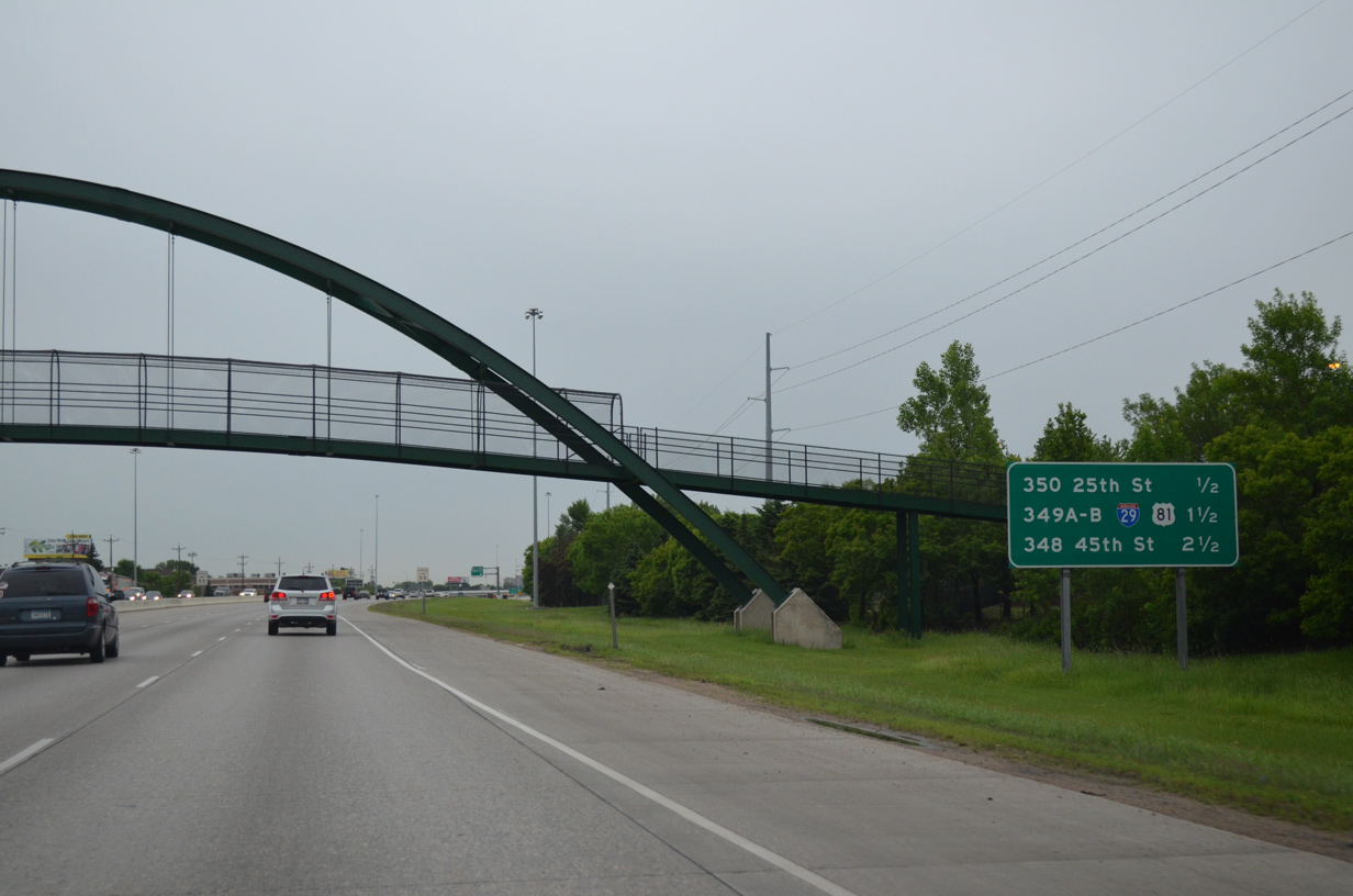
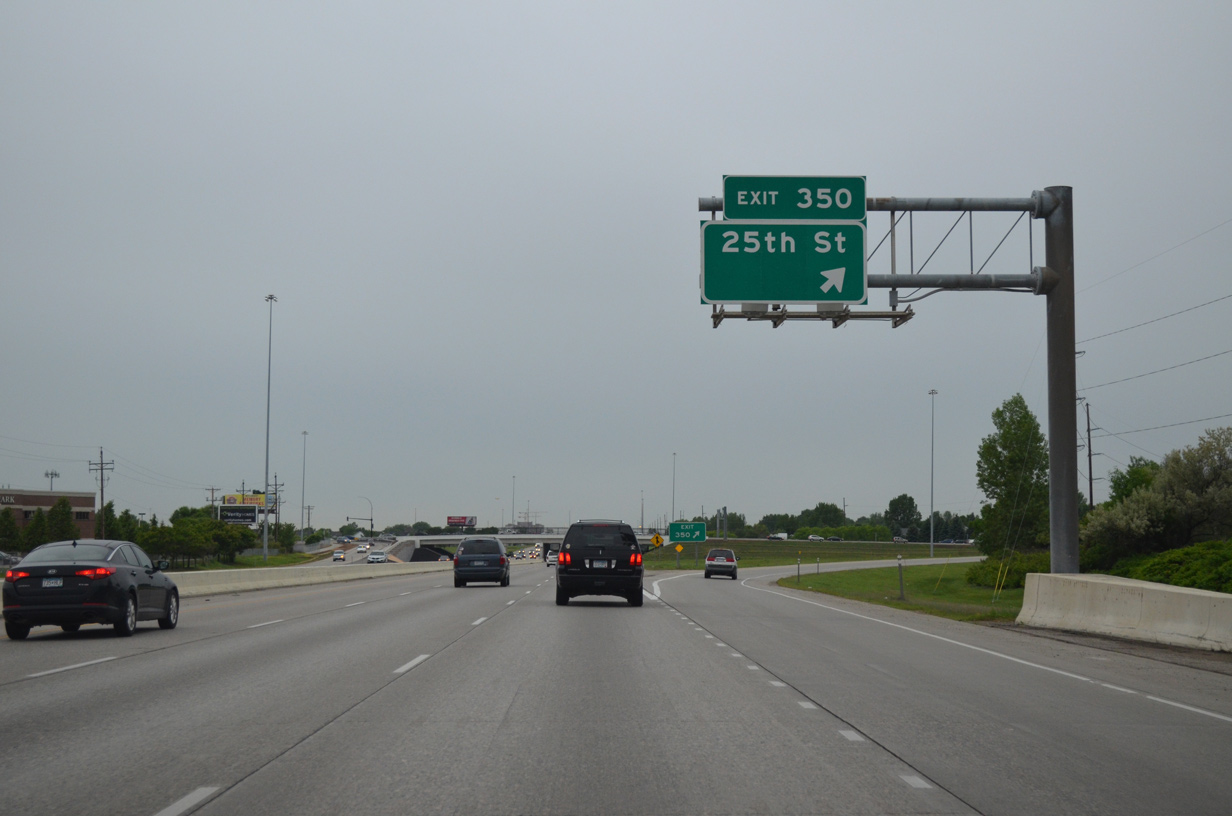
| The next westbound interchange joins I-94/U.S. 52 with 25th Street at Exit 350. 25th Street travels north to 12th Avenue North between the South High and Westgate neighborhoods. 06/17/15 |
|
| I-94/U.S. 52 west at the six-ramp parclo interchange (Exit 350) with 25th Street South. 25th Street heads south by the Bluemont Lakes and Southpointe communities to 52nd Avenue South and an exit of the city. 06/17/15 |
|
| Attached to the 25th Street South overpass is the one mile guide sign for Exits 349A/B with I-29/U.S. 81. I-29/U.S. 81 straddle western reaches of the city between Frontier and Reiles Acres. 06/17/15 |
|
| Confirming marker for I-94 west posted after 25th Street South. The 25th Street South interchange was not an original I-94 exit. 06/17/15 |
|
| This interchange sequence sign breaks the forthcoming cloverstack (Exit 349) into its north and southbound components. Drivers heading southward to Wahpeton should use I-29/U.S. 81 to Exit 23. 06/17/15 |
|
| Exit 349B departs I-94/U.S. 52 west for I-29/U.S. 81 north. The tandem continues north two miles to Main Avenue (U.S. 10) and five miles to Hector International Airport (FAR). Beyond Fargo, I-29/U.S. 81 head 77 miles to U.S. 2 at Grand Forks. 06/16/15 |
|
| Drivers bound for Sioux Falls, South Dakota and Omaha, Nebraska leave I-94/U.S. 52 west via a loop ramp (Exit 349A). A high flyover travels above between I-29/U.S. 81 south to I-94/U.S. 52 east. Venturing south, the freeway leaves Fargo at 52nd Avenue South (Frontier) on a 232 mile drive to Interstate 90 at Sioux Falls. 06/17/15 |
|
| I-94/U.S. 52 see a lane drop ahead of the on-ramp from I-29/U.S. 81 south. Merging traffic forms a third westbound lane to Exit 348 with 45th Street. 06/17/15 |
|
| Advancing west, I-94/U.S. 52 next meet 45th Street South at a six ramp parclo interchange (Exit 348). The corridor north of the freeway is well developed to Exit 346. Southward mid-2000s suburban expansion converted open fields to accommodate new apartment complexes and the like. 06/17/15 |
|
| An arrow-per-lane (APL) sign at the 42nd Street South overpass directs motorists west along I-94 to 45th Street. Points of interest served by Exit 348 include a tourist information center and the Red River Zoo. 06/17/15 |
|
| Exit 348 provides an array of lodging opportunities on the north side of I-94/U.S. 52. 45th Street otherwise continues a short distance to 13th Avenue South, a busy east-west commercial arterial leading to West Acres Shopping Center and West Fargo. 06/17/15 |
|
| Entering the six-ramp parclo interchange with 45th Street. 45th Street comprises a commuter route south into newly developed areas, including the Urban Plains, Osgood, Woodhaven and The District neighborhoods, to 52nd Avenue South. 06/17/15 |
|
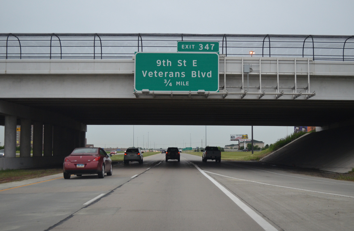
| The first of three exits for the city of West Fargo on I-94/U.S. 52 west lies 0.75 miles ahead at 9th Street East north and Veterans Boulevard south. The parclo interchange opened following a ribbon cutting ceremony held on October 1, 2009. 06/17/15 |
|
| The first U.S. 52 confirming marker posted since the US highway joined Interstate 94 in St. Paul, Minnesota appears by the 45th Street on-ramp. 06/17/15 |
|
| Suburban expansion of West Fargo spreads south of Interstate 94 from the following two exits. 9th Street East was extended south of the freeway as newly built Veterans Boulevard in 2009. 06/17/15 |
|
| Exit 347 departs I-94/U.S. 52 west for 9th Street East north into the older portions of West Fargo and south along the Fargo city line to the Osgood neighborhood at 40th Avenue South. 06/17/15 |
|
| A second set of shields for I-94/U.S. 52 west posted between Exits 348 and 347. Apartments and duplexes abut the north side of the freeway here. 06/17/15 |
|
| I-94/U.S. 52 advance one mile west through West Fargo a the parclo interchange (Exit 346) with Sheyenne Street (Cass County 17). Sheyenne Street and CR 17 serve growing areas of West Fargo southward through the expanded city limits. 06/17/15 |
|
| The final two Fargo metro area interchanges join the freeway with Sheyenne Street and the west end of U.S. 10. 06/17/15 |
|
| Beaton Drive parallels the north side of I-94 from 9th Street East to Sheyenne Street by this set of shields. The Sheyenne River flows below the freeway ahead through a culvert. 06/17/15 |
|
| Sheyenne Street leads two miles north from Exit 346B to the West Fargo city center at Business Loop I-94 & U.S. 10 (Main Avenue). 06/17/15 |
|
| Sheyenne Street / County Road 17 runs south from Exit 346A through growing suburbs of south West Fargo to the city of Horace. 06/17/15 |
|
| I-94/U.S. 52 turns northwest and to leave the city of West Fargo ahead of 13th Avenue West. 04/22/07 |
|
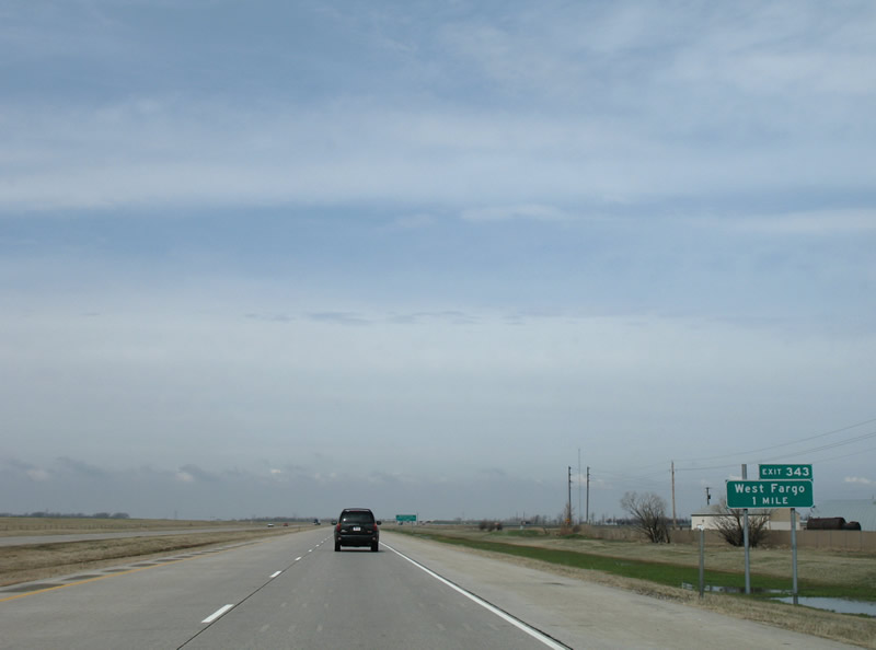
| U.S. 10/Business Loop I-94 follow Main Avenue west from Downtown Fargo and West Fargo to Exit 343. The upcoming trumpet interchange is signed simply for "West Fargo" on the freeway guide signs. 04/22/07 |
|
| Exit 343 departs I-94/U.S. 52 west for the eastbound beginning of Business Loop I-94 & U.S. 10 (Main Avenue). 04/22/07 |
|
| U.S. 10 west merges onto I-94/U.S. 52 west and ends. The US highway used to travel to Seattle, Washington, but was truncated by Interstates 90 and 94 to West Fargo by 1987. 06/17/15 |
|
| 38th Street Southwest meets I-94/U.S. 52 at Exit 342, beyond the West Fargo city limits. Portions of former U.S. 10 and U.S. 52 follow the adjacent frontage road (37th Street SE) along this stretch. 06/17/15 |
|
| Westbound at the ranch exit with 38th Street on I-94/U.S. 52. 38th Street travels north from Exit 342 to Cass County 10 and south to 52nd Avenue South through open farm land. 06/17/15 |
|
| Motorists continuing west from the 38th Street overpass next encounter a truck weigh station. 06/17/15 |
|
| Interstate 94 confirming marker devoid of its U.S. 52 companion west of Exit 342. 06/17/15 |
|
| All commercial vehicles must enter the weigh station west of Exit 342 during operating hours. 06/17/15 |
|
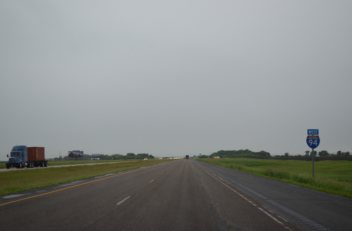
| The first distance sign posted along I-94/U.S. 52 west in North Dakota lies 12 miles ahead of the city of Casselton. Valley City follows in 50 miles while the capital city is 182 miles away. 06/17/15 |
|
| Next in line for I-94/U.S. 52 west is the diamond interchange (Exit 340) with Cass County 15 (185th Avenue Southeast). 06/17/15 |
|
| Exit 340 parts ways with I-94/U.S. 52 west for Cass County 15 (185th Avenue SE). CR 15 begins and heads south 16 miles to the community of Kindred. 06/17/15 |
|
| Ascending the westbound off-ramp to Cass County 15 at Exit 340. 185th Avenue heads north 0.9 miles to Cass County 10 east of Mapleton. Drivers bound for the city of Davenport should follow CR 15 south to CR 16 west. 06/17/15 |
Page Updated 04-11-2016.


 West
West