Interstate 84 travels a short distance in Massachusetts as an eastern extension of the Wilbur Cross Highway from Connecticut. The original dual highway was completed in 1952 and signed as Massachusetts Route 15 to U.S. 20 at Sturbridge. The connection with the Mass Pike (I-90) was completed in 1957, which led to the I-84 designation.
I-84 between East Hartford, Connecticut and the Massachusetts Turnpike (I-90) was redesignated as Interstate 86 from 1968 to 1984. During that time period, a reroute of I-84 was planned from Hartford east to Providence, Rhode Island. When that idea was dropped due to cancelled portions of the route, I-86 was decommissioned while I-84 was restored along the Wilbur Cross Highway back into Massachusetts.1
|
| Welcome to Massachusetts sign on Interstate 84 eastbound. The freeway enters the state near Hamilton Reservoir at the Hampden and Worcester County line. I-84 maintains six overall lanes from the Connecticut state line to Interstate 90 (Massachusetts Turnpike). 08/09/04 |
|
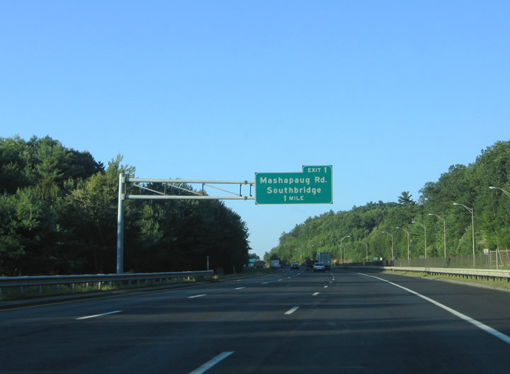
| The roadways of Interstate 84 diverge between the state line and Exit 2. Mashapaug Road crosses paths with the freeway in southwestern reaches of Southbridge, one mile to the north. A rest area lies along the northbound lanes to the right of this guide sign. 08/09/04 |
|
| One half mile south of the off-ramp (Exit 1) for Mashapaug Road. Mashapaug Road (former Route 15) stems north from Leadmine Road to meet Interstate 84 east at Haynes Street. East from Haynes Street, Mashapaug Road continues into Southbridge as South Street. 08/09/04 |
|
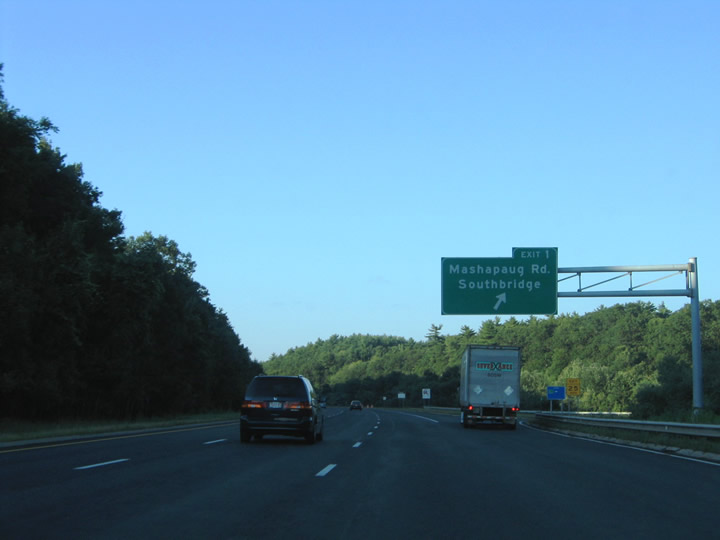
| Exit 1 leaves Interstate 84 east for adjacent Haynes Street to the north of Mashapaug Road. Haynes Street parallels I-84 eastbound between Mashapaug Road and Route 131 (Main Street) at Sturbridge. 08/09/04 |
|
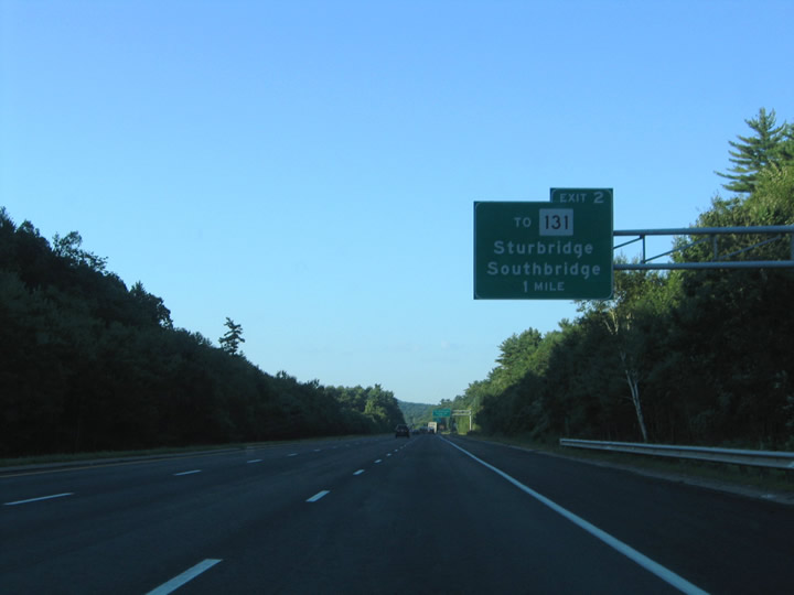
| Continuing eastbound on Interstate 84 through the town of Sturbridge. Meeting the freeway ahead is Shattuck Road, an east-west connector between Old Sturbridge Village Road and River Road at Haynes Street. River Road continues east from Exit 2 southeast to Farquhar and Mashapaug Roads. 08/09/04 |
|
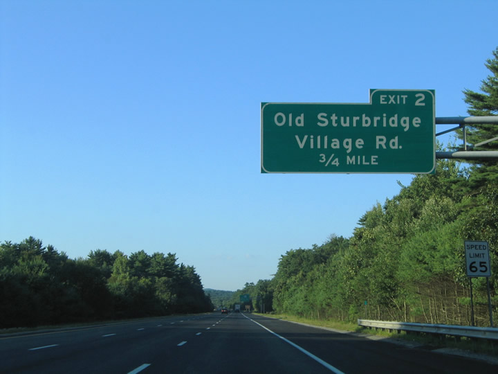
| 0.75 mile overhead for the diamond interchange (Exit 2) with Shattuck Road. Old Sturbridge Village Road heads north from Shattuck Road and Interstate 84 to Stallion Hill Road and U.S. 20 (Main Street) in west Sturbridge. 08/09/04 |
|
| Route 131 continues Route 131 northwest from Quinebaug to Sandersdale, Southbridge and Sturbridge. The state route follows Main Street northwest from Southbridge to its terminus at U.S. 20 in Sturbridge. Use Haynes Street or Farquhar Road north to access Route 131 from Exit 2. 08/09/04 |
|
| Interstate 84 eastbound at Exit 2 to Shattuck Road. Route 131 (Main Street) ends at U.S. 20 just west of Exit 3 ahead. 08/09/04 |
|
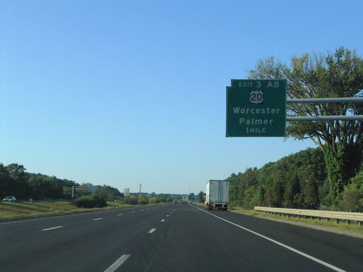
| A directional cloverleaf interchange joins I-84 and U.S. 20 by the Sturbridge town center. U.S. 20 parallels the Interstate 90 corridor throughout the entire state of Massachusetts and locally between Fiskdale and Charlton City. 08/09/04 |
|
| End advisory sign posted for the eastern terminus of Interstate 84 at Interstate 90 (Massachusetts Turnpike). Traffic not departing the freeway for U.S. 20 (Exits 3A/B) defaults onto the toll road in 1.50 miles. 08/09/04 |
|
| One half mile ahead of Exit 3A for U.S. 20 east on I-84 east. U.S. 20 (Charlton Road) travels two miles to the south end of Route 49, five miles to Charlton City and ten miles to North Oxford. 08/09/04 |
|
| Traffic interests to Worcester and Springfield via the Massachusetts Turnpike (Mass Pike) are directed northward on Interstate 84 to Interstate 90 at Exit 9. The Massachusetts Turnpike carries the entire length of I-90 between the New York state line and Logan International Airport (BOS) in Boston. 08/09/04 |
|
| Eastbound at the ramp departure of Exit 3A onto U.S. 20 (Charlton Road) eastbound. U.S. 20 provides an alternate route to the city of Worcester in lieu of the Mass Pike. The US highway meets Interstates 290 & 395 in 12 miles at Auburn. I-290 migrates north from there into Downtown Worcester. 08/09/04 |
|
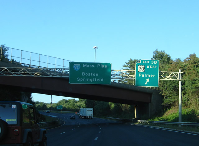
| Exit 3B loops onto U.S. 20 westbound for Main Street in Sturbridge. U.S. 20 continues west from Route 131 two miles to Fiskdale (Route 148), five miles to Brimfield (Route 19) and nine miles to Feltonville (Route 67). 08/09/04 |
|
| U.S. 20 parallels Interstate 90 to the south on the 14 mile drive to Palmer. Route 32 merges with U.S. 20 between Tenneyville and Palmer, one mile south of the Mass Pike at Exit 8. 08/09/04 |
|
| The Massachusetts Turnpike Authority posted its own Welcome to Massachusetts sign on the Interstate 84 eastbound approach to the Exit 9 toll plaza. The sign, removed by 2008, celebrated the New England Patriots Super Bowl Championships of XXXVI (versus St. Louis) and XXXVIII (versus Carolina). Boston sports celebrated world titles for both the Patriots in Super Bowl XXXIX and the Red Sox in the 2004 World Series after this sign was posted. 08/09/04 |
|
| Entering the Massachusetts Turnpike toll plaza on Interstate 84 east. E-ZPass (formerly Citizens Bank) electronic toll collection lanes lie to the right. 08/09/04 |
|
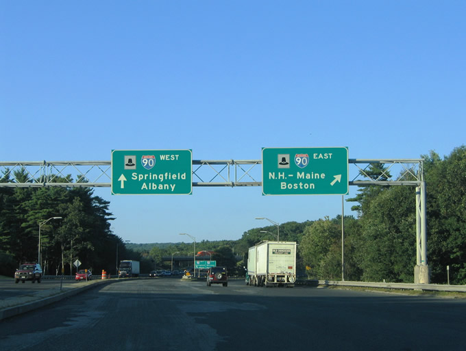
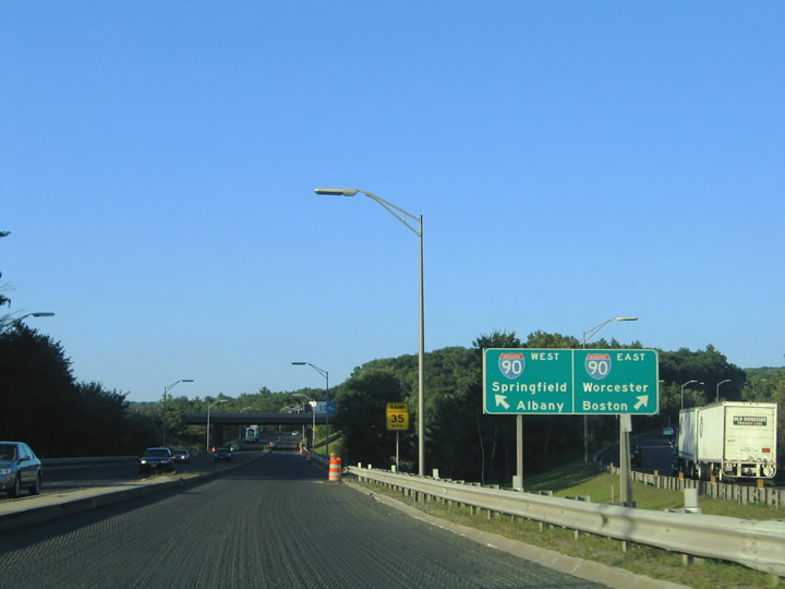
| Interstate 84 partitions into ramps for Interstate 90 east to Boston, New Hampshire, and Maine and Interstate 90 west to Springfield and Albany, New York. The Mass Pike next meets Interstates 290 & 395, 12 miles to the east near Worcester. 08/09/04 |
|
| Interstate 84 concludes at the trumpet interchange with Interstate 90 (Mass Pike). For westbound travelers, a 30 mile drive carries motorists to Springfield. 08/09/04 |
Page Updated 03-20-2004.

 East
East