|
| Exit 62 to Buckland Street separates from within the exchange joining I-84 east with I-291 west. 05/30/22 |
|
| Buckland Street heads north from the intersection of Tolland Turnpike and Adams Street at Buckland to The Shoppes at Buckland Hills mall and South Windsor. 08/09/04 |
|
| A left exit also joins the HOV lane with Buckland Street. Advancing north into South Windsor, Buckland Street becomes Buckland Road en route to Route 30 (Ellington Road) and Route 194 (Sullivan Avenue). 08/09/04 |
|
| Interstate 84 passes south of The Shoppes at Buckland Hills and other retail along the ensuing stretch eastbound. 05/30/22 |
|
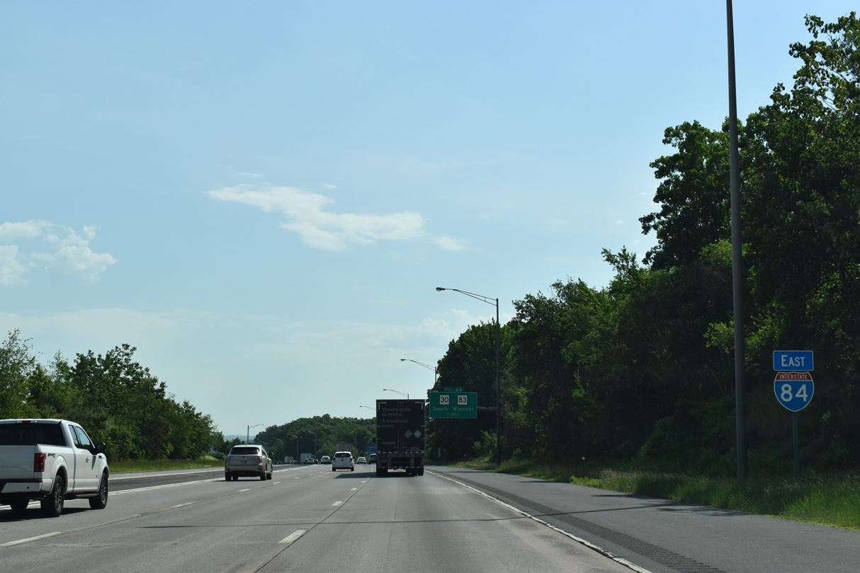
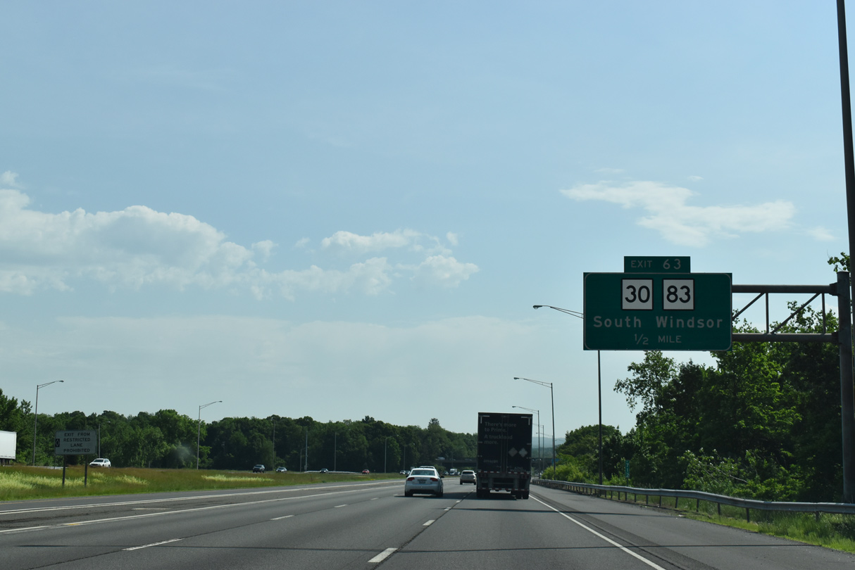
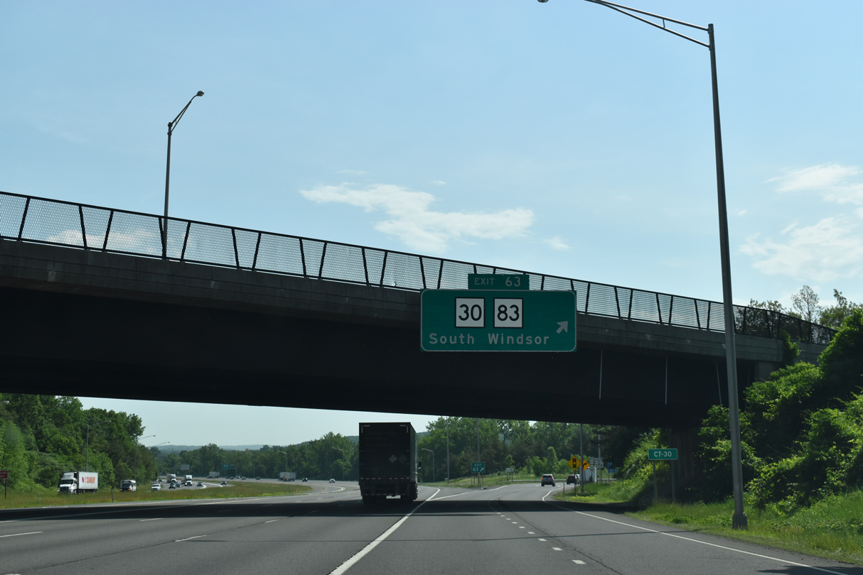
| Route 30 (Deming Street) heads southeast from the town of South Windsor to meet Interstate 84 at Exit 63. 05/30/22 |
|
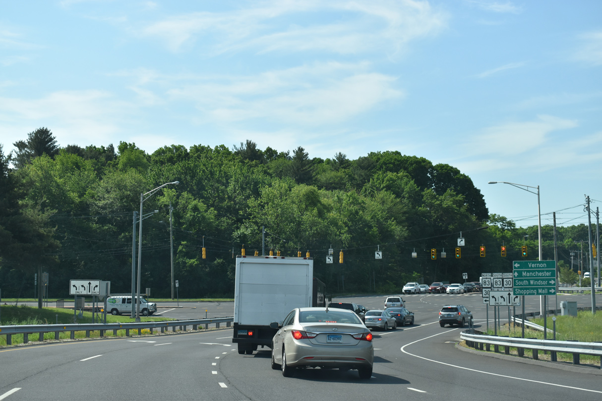
| Route 30 (Deming Street) combines with Route 83 for 1.50 miles east from the parclo B2 interchange (Exit 63) with Interstate 84 to Talcottville and Kelly Road. 05/30/22 |
|
| Exit 63 lloops south across the Hockanum River into the intersection joining Route 30 along Deming Street and Tolland Turnpike with Route 83 (Oakland Street) south to Central Manchester. 05/30/22 |
|
| Route 30 travels 20.94 miles overall from I-291 at U.S. 5 in South Windsor to Route 190 to West Stafford. 05/30/22 |
|
| 27.56 miles in length, Route 83 forms a multi state highway with Massachusetts Route 38 at East Longmeadow. The state route follows Main Street through Downtown Manchester south en route to Glastonberry. 05/30/22 |
|
| Route 30/83 (Hartford Turnpike) converge with Interstate 84 again at Exit 64 in west Vernon. A left exit ramp connects the HOV lane to Route 30/83 as well. 08/09/04 |
|
| The ramp to Route 30/83 separates with Exit 64 connecting to Route 83 (Talcottville Road) and Exit 65 to Route 30 (Hartford Turnpike). Route 30 heads east from Route 83 and Kelly Road through Vernon Center adjacent to Interstate 84. 08/09/04 |
|
| Route 83 (Talcottville Road) continues north from Route 30 to Route 74 west of Rockville. The HOV-2 lane concludes beyond Exits 64/65. 08/09/04 |
|
| Interstate 84 remains eight lanes wide east of the Dobson Road entrance ramp in the town of Vernon. 08/09/04 |
|
| The next exit from Interstate 84 eastbound is for Tunnel Road and Bolton Road in Vernon. Tunnel Road travels south from Route 30 (Hartford Turnpike) to Lake Street. 08/09/04 |
|
| Exit 66 links I-84 eastbound with S Frontage Road (Route 541) midway between Tunnel and Bolton Roads. Bolton Road meanders 2.84 miles south from Route 541 to Bolton Lakes and Quarry Road in Bolton. 08/09/04 |
|
| The 0.82 mile long course of Route 541 includes Bolton Road north from S Frontage Road to Route 30 (Hartford Turnpike) at Center Road. 08/09/04 |
|
| Progressing northeast by Belding Wildlife Management Area, the last exit in the town of Vernon joins I-84 with Route 31 (Mile Hill Road). 08/09/04 |
|
| 14.34 miles in length, Route 31 runs north from Exit 67 to Route 74 (E Main Street) at Rockville and south to Route 32 at Perkins Corner. 08/09/04 |
|
| Interstate 84 reduces to six overall lanes ahead of the diamond interchange (Exit 67) with Route 31 (Reservoir Road). Route 31 combines with U.S. 44 (Boston Turnpike) in 4.6 miles and reaches Coventry Center in 9.9 miles. 08/09/04 |
|
| Interstate 84 enters the town of Tolland just east of Exit 67 and Gages Brook and west of Reed Hill. The ensuing exit is for Route 195 (Merrow Road) near the town center. 08/09/04 |
|
| Passing between Crandall Park and Tolland Marsh Pond, Interstate 84 continues a half mile to Exit 68 for Route 195 (Merrow Road). 08/09/04 |
|
| Interstate 84 gains 170 feet in elevation from the Cider Mill Road underpass northeast to point beyond Old Cathole Road N. 08/09/04 |
|
| A 15.90 mile long highway, Route 195 north ties into Route 74 in central Tolland. Southeast from Exit 68, Route 195 leads to Mansfield and Route 14/66 at Willimantic. 08/09/04 |
|
| Interstate 84 enters Nye-Holman State Forest just ahead of the diamond interchange (Exit 69) with Route 74 (Tolland Stage Road). Route 74 is 22.23 miles in length between Route 194 in South Windsor and U.S. 44 at West Ashford. 08/09/04 |
|
| Crossing the Willimantic River south of Exit 69, Route 74 (Tolland Stage Road). meets Route 32 (River Road) at West Willington. Route 74 continues 1.9 miles east from Route 32 to Route 320 (Ruby Road) at Willington Center. 08/09/04 |
|
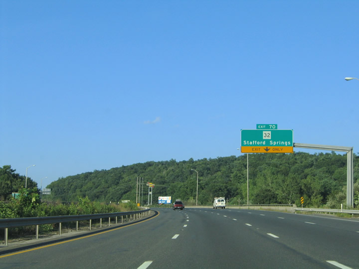
| Rest areas line both roadways along I-84 between the Willimantic River and Exit 70 to Route 32 (River Road). Route 32 converges with I-84, 1.4 miles north of West Willington and 4.2 miles south of Stafford Springs. 08/09/04 |
|
| Interstate 84 crosses over the New England Central Railroad railroad line leading into the modified diamond interchange (Exit 70) with Route 32 (River Road). 54.88 miles in the Nutmeg State, Route 32 is part of a multi state highway between New London and Keene, New Hampshire. 08/09/04 |
|
| Right in right out (RIRO) ramps at Exit 71 connects Interstate 84 with Route 320 along Ruby Road. 08/09/04 |
|
| Route 320 originates 7.05 miles to the south from Route 195 in north Mansfield and ends at the RIRO ramps with westbound Interstate 84. 08/09/04 |
|
| Exit 71 departs I-84 east for Route 320 (Ruby Road) south 3.1 miles to the Willington town center. 08/09/04 |
|
| Interstate 84 crosses the northwestern corner of Ashford at Snow Hill ahead of the diamond interchange (Exit 72) with Route 89 (Fish Point Road / Ferrence Road). 08/09/04 |
|
| North from Exit 72, Route 89 (Fish Point Road) concludes in 0.58 miles at Route 190 (Buckley Highway) and Nipmuck State Forest in the town of Tolland. 16.25 miles long, the south end of Route 89 is at Route 195 and Mansfield Center. 08/09/04 |
|
| Route 89 (Ferrence Road) continues 3.9 miles south from Exit 72 by Morey Pond to Westford and 8.0 miles to U.S. 44 (Ashford Center Road) at Warrenville by Ashford Town Hall. 08/09/04 |
|
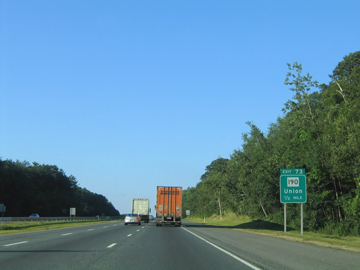
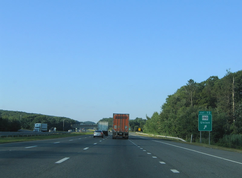
| I-84 continues one mile northeast from Route 89 to Exit 73 for Route 190 (Buckley Highway) in the town of Union. 08/09/04 |
|
| Interstate 84 runs along the north side of Lead Mine Hill ahead of the diamond interchange (Exit 72) with Route 190 (Buckley Highway). 08/09/04 |
|
| Route 190 straddles northern reaches of Connecticut for 28.27 miles between Route 75 at Suffield and Route 171 (Bigelow Hollow Road) two miles to the east of Exit 73. 08/09/04 |
|
| Traversing areas adjacent to Nipmuck State Forest, Interstate 84 continues northward to Exit 74 at the west end of Route 171 (Buckley Highway). Route 171 overtakes Buckley Highway from Route 190, 2.3 miles to the south. 08/09/04 |
|
| The modified diamond interchange (Exit 74) with Route 171 (Buckley Highway/ Holland Road) and Gilbronson Road lies between Hamilton Reservoir and Mashapaug Pond at Mashapaug. 08/09/04 |
|
| Route 171 travels 20.70 miles overall from I-84 / Holland Road to Woodstock and U.S. 44/Route 12 at Putnam. Holland Road extends 0.26 miles from the end of Route 171 into Holland, Massachusetts. 08/09/04 |
Page Updated 03-09-2023.

 East
East