
Traveling 5.44 miles, Interstate 291 comprises an urban loop through Springfield northeast from I-91 to the Massachusetts Turnpike (I-90). Construction of the route commenced in 1954, with a 1.4 mile long segment spurring south from I-90 to U.S. 20 and Route 20A at Exit 5. That portion opened in 1957, with the remainder of I-291 under construction between 1967 and 1970.1 U.S. 20 overlaps with the freeway southwest to Interstate 91 north.
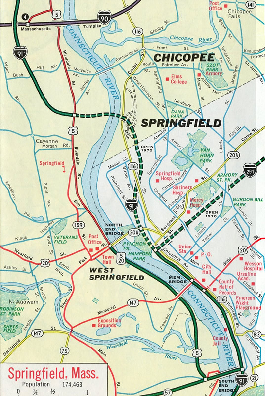
Springfield, Massachusetts - 1969
 |
 | U.S. 20 leaves Interstate 91 southbound for Interstate 291 eastbound via a high flyover near Downtown Springfield. Travelers using this ramp see advance signage for the Chestnut Street off-ramp (Exit 2A) into Downtown. Chestnut Street joins the freeway with Liberty Street to the south and Route 20A (Carew Street) to the north. 06/28/05 |
 | Interstate 291 eastbound begins initially with roadways from the exchange with Interstate 91. The inner roadways serve interests from the north. Exit 2A departs here for Chestnut Street, while Exit 2A on the outer roadway (from Interstate 91 north) serves Dwight Street. This set of signs was replaced after 2007 with the pull through panel for I-291 removed. 06/28/05 |
 | The two eastbound roadways converge just east of the Chestnut / Dwight Street interchange complex. A begin Interstate 291 sign assembly stands ahead of the gore point at the roadway merge. 06/28/05 |
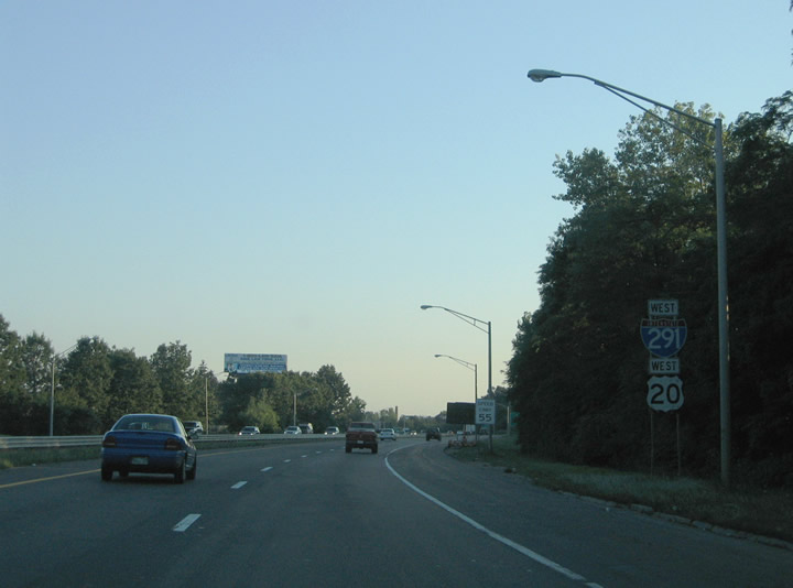
 | The first Interstate 291 & U.S. 20 eastbound reassurance shield assembly lies one quarter mile west of the Armory Street split diamond interchange (Exit 3). Armory Street travels north from State and Federal Streets to Van Horn Park and Springfield Street near the Chicopee city line. 06/28/05 |
 | Exit 3 leaves Interstate 291 & U.S. 20 east. The interchange exists at the convergence of Armory and Liberty Streets, with Armory Street traveling northwest-southeast, and Liberty Street traveling southwest-northeast between Downtown Springfield and Chicopee Falls. This set of overheads was replaced after 2007. 06/28/05 |
 | Interstate 291 & Route 20 eastbound reassurance markers posted after the on-ramp from Armory and Liberty Streets. The assembly was replaced by 2007 to correct the error of Route 20 for U.S. 20. U.S. 20 otherwise remains overlaps to Exit 5A (Page Boulevard). 06/28/05 |
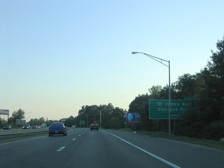
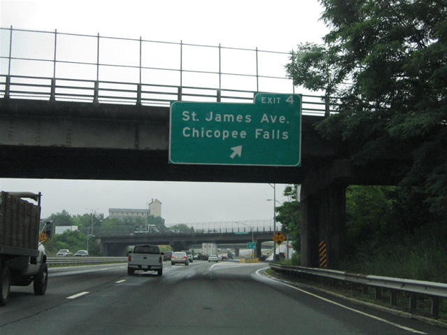 | Tapley Street passes over Interstate 291 & U.S. 20 at the ramp departure of Exit 4 to St. James Avenue. St. James Avenue heads north from the McKnight and Bay section of Springfield to Athol Junction, East Springfield and ultimately to Broadway Street and Chicopee Falls. This bridge mounted sign was removed and replaced with a new overhead sign assembly by 2007. 06/28/05 |
| East |
 | Interstate 291 eastbound concludes at the signalized intersection with the Mass Pike access road and Burnett Avenue in Chicopee. Traffic to Interstate 90 passes through a toll plaza before joining the Massachusetts Turnpike via a trumpet interchange (Exit 6). Burnett Avenue continues east to 1st Avenue and Chicopee Memorial State Park ahead. 08/09/04 |
| West |
 | Approaching the Massachusetts Turnpike entrance and transition into Interstate 291 on Burnett Avenue west. Burnett Avenue comprises a surface boulevard through southeastern Chicopee and Ludlow to the junction with I-90 and I-291. The Mass Pike travels east-west through Chicopee, just north of Springfield between Interstate 91 and Ludlow. 08/09/04 |
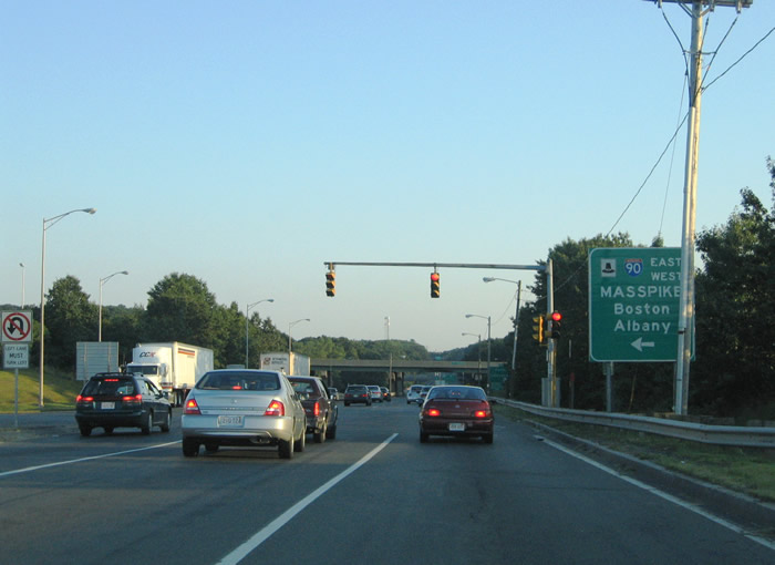 | Mast arm supported traffic signals govern the movements between Burnett Road west, Interstate 291 east and the Exit 6 access road to the Mass Pike. Interstate 90 follows all of the Mass Pike between the New York State line, southeast of Albany, and Logan International Airport (BOS) in Boston. 08/09/04 |
 | Burnett Road transitions immediately into Interstate 291 westbound after the Mass Pike entrance ramp. The freeway passes under the I-90 mainline and immediately enters the folded diamond interchange (Exit 6) with Fuller Road at Chicopee Falls. Fuller Road parallels the Chicopee River west from Shawingan Drive to Route 33 (Memorial Drive). Route 141 (Main Street) follows the south banks of the river nearby and is accessible from Exit 6 via the Veterans Memorial Bridge. Use Exit 6 for Westover Air Reserve Base in Chicopee. 08/09/04 |
 | Interstate 291 crosses the Chicopee River between Fuller Road and Route 141 (Main Street). The next interchange brings U.S. 20 onto I-291 westbound from Page Boulevard. Route 20A continues west along Page Boulevard along the original U.S. 20 alignment to Carew Street and Downtown Springfield. The pull-through panel in place here included an Interstate 291 Massachusetts shield. All guide signs for I-291 were replaced by 2007. The pull through sign here was removed during that resigning. 08/09/04 |
 | A three-quarter cloverleaf-interchange facilitates movements between Interstate 291 and U.S. 20 / Route 20A (Page Boulevard) at Exit 5. U.S. 20 east meanders through Indian Orchard from Interstate 291 to Pasco Road and Boston Road. Route 20A parallels Interstate 291 & U.S. 20 west through East Springfield via St. James Boulevard. 08/09/04 |
| |
 | Reassurance shield assembly for Interstate 291 & U.S. 20 westbound posted after the two routes combine at Exit 5. U.S. 20 follows all of Interstate 291 from East Springfield west to Interstate 91 north (Exit 1B). 08/09/04 |
 | Interstate 291 & U.S. 20 westbound continue southwest to the Athol Junction section of Springfield at Exit 4. A modified diamond interchange joins the freeway with St. James Avenue and Page Boulevard near Tapley Street. 08/09/04 |
 | Travelers bound for the Eastern States Exposition are advised well ahead of time to take Interstate 91 southbound (Exit 1A) from I-291 /U.S. 20 westbound. The venue lies along Route 147 west of I-91 (Exit 7) in West Springfield. 08/09/04 |
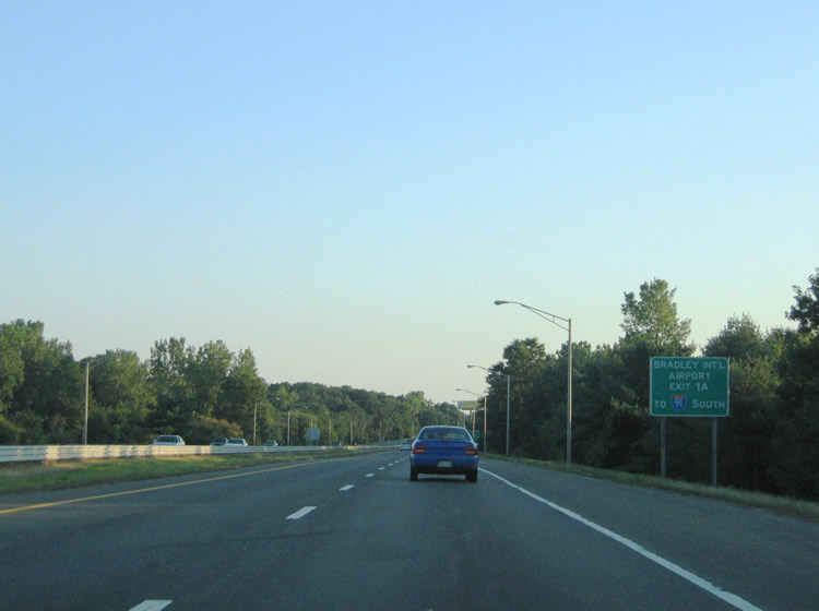 | Drivers destined for Bradley International Airport (BDL) should also take Interstate 91 south from Exit 1A at the Interstate 291 western terminus. The airport lies west of I-91 (Exit 40) in Windsor Locks, Connecticut. 08/09/04 |
 | One half mile ahead of Exit 4 to Page Boulevard and St. James Avenue on Interstate 291 & U.S. 20 westbound. St. James Avenue travels north-south between Magazine / State Streets and Broadway Street in south Chicopee. Broadway Street meets Route 141 (Main Street) just west of Chicopee Falls. 08/09/04 |
 | Exit 4 leaves Interstate 291 & U.S. 20 west for Page Boulevard and St. James Avenue. The eastbound off-ramp loops over the Interstate 291 mainline and merges with the southbound off-ramp ahead of Page Boulevard. Use St. James Avenue south for the Blunt Park, McKnight and Bay sections of the city. 08/09/04 |
 | The first sign advising motorists of the Interstate 291 terminus stands ahead of the St. James Avenue over crossing, 1.50 miles east of Interstate 91. There are no other end advisory signs posted along I-291 west. 08/09/04 |
 | Interstate 291 & U.S. 20 westbound reassurance shields posted after the on-ramp from St. James Avenue. 06/28/05 |
 | Progressing westward toward Downtown Springfield on Interstate 291 & U.S. 20, one half mile ahead of the split diamond interchange (Exit 3) with Liberty and Armory Streets. The surface streets cross paths at a traffic rotary above Interstate 291 between Stafford and Genesee Streets in central Springfield. 08/09/04 |
 | A diagrammatic overhead for the Interstate 91 and Exits 2A/B ramp split was posted one mile east of the Interstate 291 end near Armory Street (Exit 3). It was taken down and replaced with a new side-mounted overhead by 2007. Interstate 291 otherwise ends at a tri-level stack interchange with its parent at Pynchon Park along the Connecticut River. 06/28/05 |
 | Truck traffic destined for Agawam via the South End Bridge (U.S. 5) was directed onto Interstate 91 north to U.S. 20 west (North End Bridge) to U.S. 5 in West Springfield. U.S. 5 travels south along the west banks of the Connecticut River from there to Agawam and Route 57. This sign was removed by 2007. 06/28/05 |
 | Armory and Liberty Streets pass over Interstate 291 & U.S. 20 one half mile ahead of their split at Interstate 91. Exit 2B leaves with Exit 1B for Interstate 91 north and Dwight Street with two lanes to the left. Exit 2A departs with Exit 1A for Interstate 91 south and Chestnut Street to the right. U.S. 20 briefly merges with I-91 between Exit 2B and Plainfield Street before crossing the North End Bridge to West Springfield nearby. 08/09/04 |
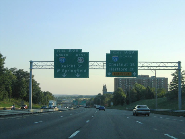 | Traffic merging onto Interstate 291 & U.S. 20 westbound from Armory Street expand the roadway to four lanes. The Dwight Street (Exit 2B) and Chestnut Street (Exit 2A) off-ramps lead to the Springfield central business district to the south. Interstate 91 north connects with I-391 to Chicopee and Holyoke and leads south to Agawam and Longmeadow. 08/09/04 |
 | U.S. 20 westbound departs Interstate 291 for Exit 1B to the North End Bridge and West Springfield. The US route follows Westfield Street to Westfield from the Connecticut River. Interstate 91 northbound otherwise travels 1.50 miles to its split with Interstate 391 at Exit 12. I-391 spurs north 4.46 miles to U.S. 202 in east Holyoke. 08/09/04 |
 | Chestnut Street crosses over the dual roadways of I-291 west as ramps for Exits 2B/A depart. Exit 2B descends from the northbound I-91 on-ramp to Dwight Street below. Dwight Street intersects Route 20A (Carew Street) two blocks to the north. 08/09/04 |
 | Exit 2A leaves the I-91 southbound off-ramp to join Chestnut Street south into Downtown Springfield. Traffic otherwise merges onto the left side of Interstate 91 south ahead on the 25 mile drive to Hartford, Connecticut. 08/09/04 |
 | A look at the inner roadway of Interstate 291 & U.S. 20 west at the Dwight Street off-ramp (Exit 2B). Dwight Street parallels Chestnut Street north from State Street to Dover Street near Interstate 91 at Exit 10. A return ramp onto Interstate 91 north is available at the end of Exit 2B. 06/28/05 |
 | The Interstate 291 & U.S. 20 westbound transition onto Interstate 91 north features a slip ramp onto the Exit 9 collector distributor roadway for the North End Bridge (U.S. 20). U.S. 20 cross the Connecticut River between I-91 and a rotary with U.S. 5 (Riverdale Road). 06/28/05 |
 | Interstate 291 westbound ends at the partition between ramps to I-91 north to I-391 and U.S. 20 west across the North End Bridge. Greenfield (Route 2) lies 36 miles to the north along Interstate 91. 06/28/05 |
| scenes |
 | Page Boulevard stems east from St. James Avenue at the interchange (Exit 4) with I-291/U.S. 20 to Route 20A. St. James Avenue continues north toward Chicopee Falls while Page Boulevard eventually becomes part of U.S. 20 east of I-291 at Exit 5. These signs were replaced by 2007. 06/28/05 |
 | The westbound on-ramp to I-291/U.S. 20 from St. James Avenue south at Page Boulevard. The freeway continues a short distance to Interstate 91 near Downtown Springfield. I-91 continues from there south to Hartford, Connecticut, while U.S. 20 spans the Connecticut River into West Springfield. The entire overhead assembly here was replaced by 2007. 06/28/05 |
Sources:
- Springfield Expressway (I-291). BostonRoads.com.
Photo Credits:
08/09/04, 06/28/05 by AARoads and Carter Buchanan
Connect with:
Interstate 90 - Massachusetts Turnpike
Interstate 91
Page Updated 09-23-2006.