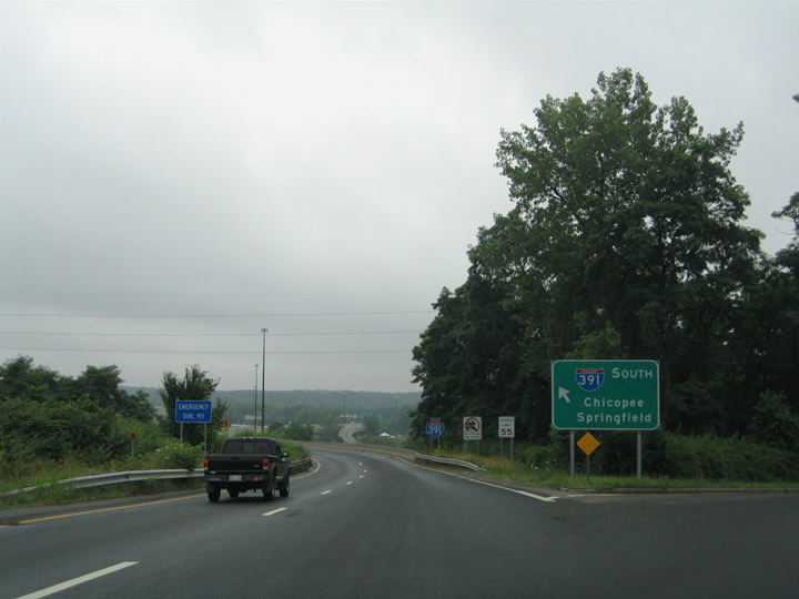
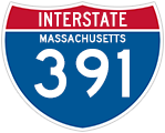
Designated in 1965, Interstate 391 forms a 4.46 mile spur north from I-91 through Chicopee to Holyoke. The initial portion of I-391 to open in 1970 was the 0.75 mile section from I-91 north to Massachusetts 116 (Exit 2). The remainder of the route was delayed due to funding issues and redesign until its completion in 1982.1
|
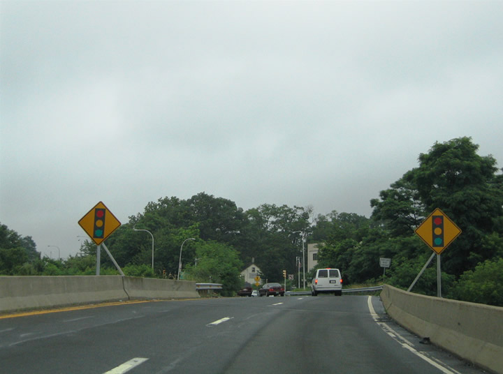
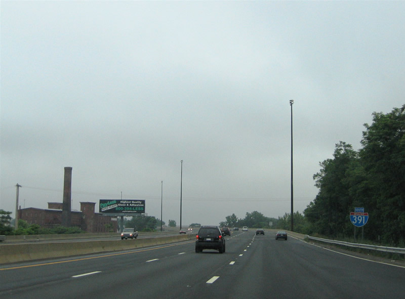
| Interstate 391 commences its short northward journey after splitting with Interstate 91 north of Springfield. I-91 turns west to span the Connecticut River to U.S. 5 while I-391 motorists see a begin shield. 06/28/05 |
|
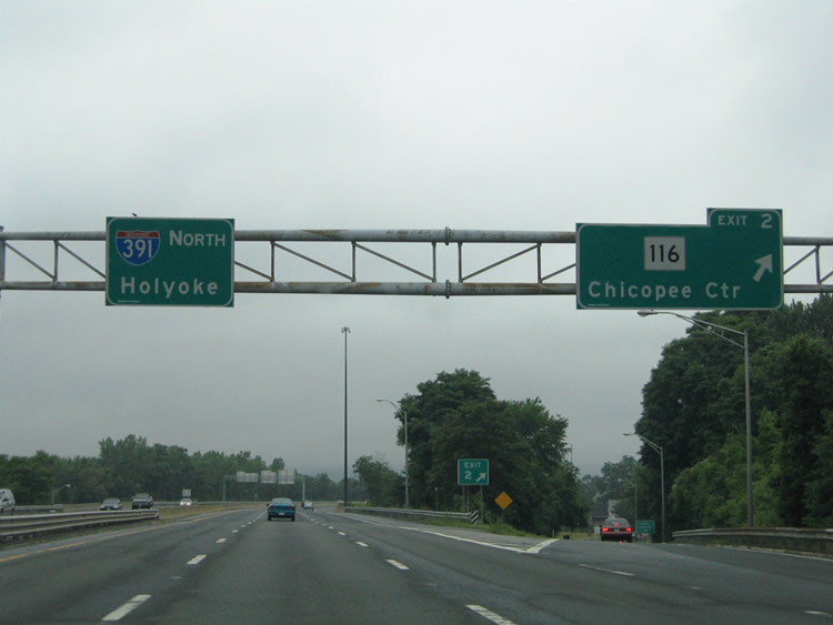
| Route 116 (Center Street) intertwines with Interstate 391 through the city of Chicopee. The first two interchanges of the freeway join with the state route. 06/28/05 |
|
| A diamond interchange (Exit 2) joins Interstate 391 with Route 116 (Center Street) southwest of the Chicopee city center. Route 116 follows Center Street north from Main Street in Springfield to the Springfield Street bridge over the Chicopee River. 06/28/05 |
|
| Exit 3 serves the Chicopee area communities of Willimansett and Westover. Route 116 (Chicopee Street) heads northwest from the Davitt Memorial Bridge and Granby Road to Willimansett. Granby Road ventures east from Chicopee Street to Westover Air Reserve Base via Westover Road. 06/28/05 |
|
| Interstate 391 spans the Chicopee River and then enters a three-quarter cloverleaf interchange with Chicopee Street. Route 116 continues three miles through Willimansett before passing under Interstate 391 again near the Connecticut River. Granby River heads 2.75 miles northeast to Route 33 (Memorial Drive) at Westover Road. 06/28/05 |
|
| Northbound reassurance marker posted near the Interstate 90 (Massachusetts Turnpike) over crossing. There is direct access between the Mass Pike and Interstate 391. 06/28/05 |
|
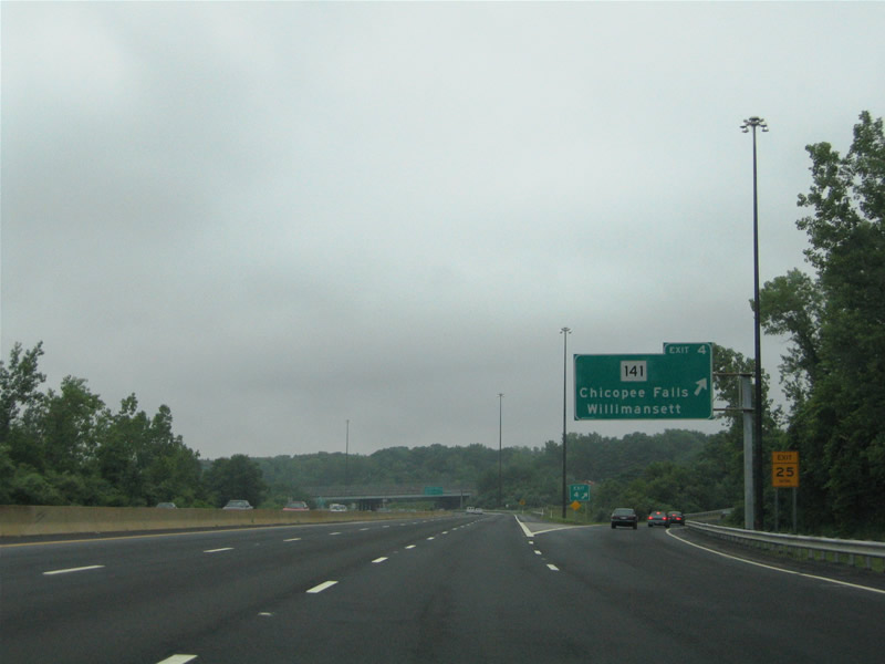
| Next in line for northbound travelers is the six-ramp parclo interchange (Exit 4) with Route 141 (Grattan Street). Route 141 enters Chicopee from Chicopee Falls to the southeast. The state route joins Route 116 (Chicopee Street) nearby at Willimansett. 06/28/05 |
|
| One half mile south of the off-ramp (Exit 4) to Route 141 (Grattan Street) on i-391 north. Route 141 overlaps with Route 116 northward along Chicopee Street to the Cabot Street bridge across the Connecticut River. The two split in the Holyoke city center at the intersection of Appleton and Race Streets. 06/28/05 |
|
| Exit 4 departs Interstate 391 northbound for Route 141 (Grattan Street). Grattan Street carries the state route from Chicopee Street near Rivers Park southward 2.4 miles to Bridge Street (Route 33) at the Chicopee River north of Chicopee Falls. 06/28/05 |
|
| Interstate 391 continues north toward its crossing of the Connecticut River. The final three departure points of the freeway serve the city of Holyoke. 06/28/05 |
|
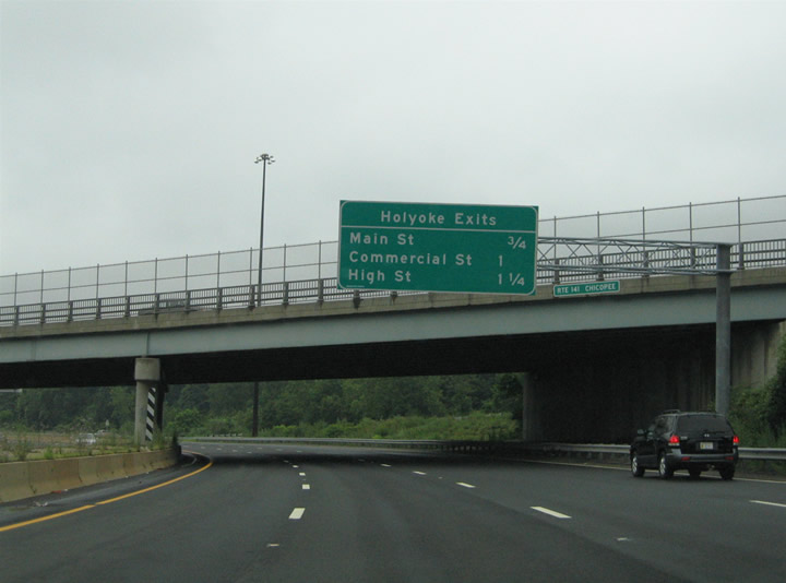
| Six lanes of Interstate 391 span the Connecticut River between Chicopee and Holyoke. Forthcoming Exit 5 descends from over the north banks of the river above Water Street to Main Street in one half mile. 06/28/05 |
|
| A second road ends sign advises motorists of the impending freeway transition into Resnic Boulevard. The road does not end per se, it just transitions into a divided surface boulevard. Exit 5 meanwhile sinks from the viaduct to Main Street below.
Main Street travels east-west from U.S. 5 (Ingleside Street) to Route 116 (Canal Street) in the city center. 06/28/05 |
|
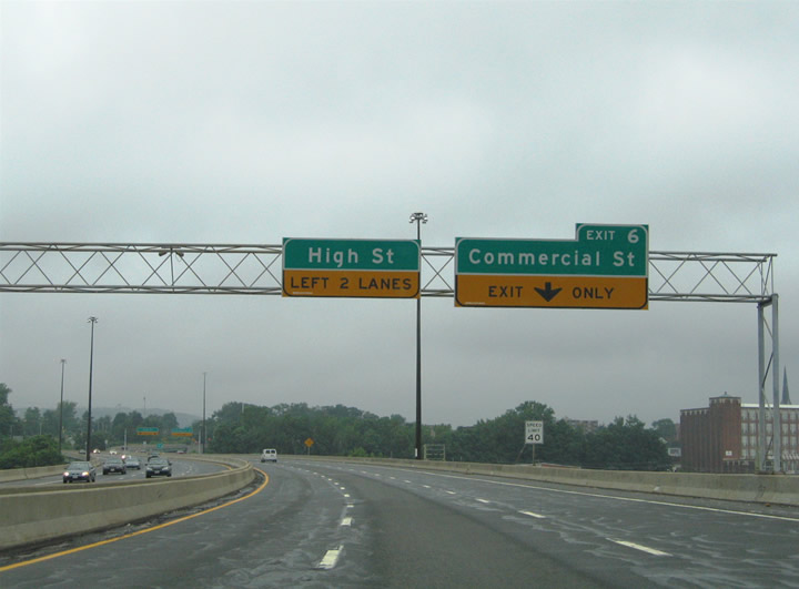
| Interstate 391 north prepares to partitions into lanes for Exit 6 (Commercial Street) and the transition onto Resnic Boulevard (at High Street). Commercial Street spurs east from the wye interchange of Exit 6 five blocks to Cabot Street. 06/28/05 |
|
| Drivers bound for Commercial Street east to Jackson or Cabot Streets depart Interstate 391 north while the freeway mainline transitions into Resnic Boulevard ahead at the signalized intersection with High Street. High Street parallels Commercial Street one block to the north en route to Downtown Holyoke. 06/28/05 |
|
| The freeway end ascends above the Commercial Street southbound on-ramp ahead of the one way street couple of High and Maple Streets. 06/28/05 |
|
| Ground level traffic lights govern the movements at the I-391 northbound transition onto Resnic Boulevard at High Street. High Street (east) and Maple Street (west) travel between nearby South Street and Lyman Street within the city center. Motorists continuing north on Resnic Boulevard will reach Beech Street in 0.4 miles. Beech Street leads west to U.S. 5 & 202 south and east to U.S. 202 north. 06/28/05 |
|
| The separate roadways of Resnic Boulevard converge beyond the signal with Maple Street west. Nearby U.S. 202 travels east from Westfield to South Hadley through Holyoke. 06/28/05 |
|
| Resnic Boulevard southbound transitions into Interstate 391 at High Street. The freeway bends southeast quickly at the Kay Avenue off-ramp to South Street. 06/28/05 |
|
| A slip ramp joins a short section of Kay Street ahead of its intersection with South Street. South Street parallels the I-391 viaduct to Main Street. Since there are no southbound exits to Holyoke from Interstate 391 itself, the Kay Street ramp represents the only departure point ahead of the Connecticut River and Chicopee. 06/28/05 |
|
| The first southbound reassurance marker lies a short distance beyond the Kay Street off-ramp at the wye interchange (Exit 6 from I-391 north) with Commercial Street. 06/28/05 |
|
| Interstate 391 southbound expands to six lanes with the addition of the Commercial Street on-ramp. A second on-ramp brings motorists on board from Main Street at Exit 5. From here the freeway spans the Connecticut River en route to the city of Chicopee, of which is served by four off-ramps. 06/28/05 |
|
| Southbound drivers bound for Chicopee are provided with two ramps to Route 141 (Grattan Street) at Exits 4B/A. Route 141 travels south from Holyoke with Route 116 across the Cabot Street-Chicopee Street bridge over the Connecticut River. Once in Chicopee, the two turn west along Chicopee Street for a 0.9 mile drive to their split at Grattan Street. 06/28/05 |
|
| Exit 4B serves the Willimansett community of west Chicopee via Route 141 (Grattan Street) westbound. Grattan Street meets Route 116 (Chicopee Street) nearby at Willimansett. Use Meadow Street or Route 116 southbound for more of Willimansett. 06/28/05 |
|
| A loop ramp carries motorists onto Route 141 (Grattan Street) east for the 2.2 mile drive to Chicopee Falls. Grattan Street carries the state route to junction Route 33 (Memorial Drive) at Bridge Street across the Connecticut River. Once in Chicopee Falls, Route 141 follows Main Street. 06/28/05 |
|
| Continuing southward along Interstate 391 toward the crossing under Interstate 90 (Massachusetts Turnpike). There is no direct access between the two freeways. Travelers destined for I-90 should use Route 141 east to Granby Road for the Montgomery Street interchange with the Mass Pike (Exit 5). 06/28/05 |
|
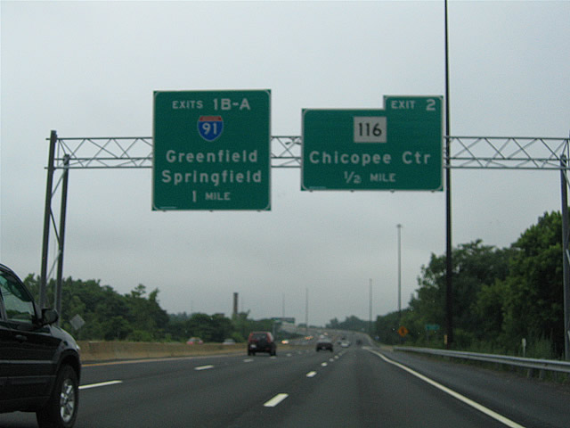
| Two miles notice is given to Interstate 391 southbound travelers for the terminal interchange with Interstate 91 near the Connecticut River. Interstates 391 and 91 provide a direct route to Downtown Springfield from Chicopee and Holyoke. 06/28/05 |
|
| An Interstate 391 ends sign follows the two mile overhead for Interstate 91 (Exits 1B/1A). 06/28/05 |
|
| Interstate 391 approaches the first of two interchanges with Route 116 (Chicopee Street). Route 116 continues southward along Chicopee Street from its overlap with Route 141 through Willimansett to Granby Road and the Davitt Memorial Bridge across the Chicopee River. 06/28/05 |
|
| Exit 3 departs Interstate 391 south as a loop ramp to Chicopee Street. Route 116 turns south across the Chicopee River for Center Street at Granby Road. Granby Road stems northeastward toward the Westover community, eventually transitioning into Westover Road at junction Route 33 en route to Westover Air Reserve Base. 06/28/05 |
|
| A diamond interchange joins Interstate 391 with Route 116 (Center Street) again at Exit 2. The state route travels through the Chicopee city center via Center Street just east of the freeway. 06/28/05 |
|
| Southbound reassurance shield assembly posted between Exits 3 and 2. 06/28/05 |
|
| Drivers bound for Route 116 (Center Street) depart Interstate 391 south at Exit 2. Route 116 continues southwest from Hampden Street under the freeway to become Main Street in the city of Springfield. The state route ends at Route 20A (Carew/Plainfield Streets). 06/28/05 |
|
| Interstate 391 southbound defaults onto Interstate 91 south for Downtown Springfield and Hartford, Connecticut. Exit 1B provides access onto Interstate 91 north across the Connecticut River to U.S. 5. 06/28/05 |
|
| Three lanes continue onward to Interstate 91 south ahead of its brief merge with U.S. 20 at Exit 8. I-91 and U.S. 20 combine for a short period ahead of their interchange with Interstate 291 near Downtown Springfield. 26 miles separate Exit 1A from Downtown Hartford, Connecticut.
Northbound travelers meet Interstate 90 (Mass Pike) in three miles and Greenfield (junction Route 2) in 34 miles. Exit 1B mainly exists to facilitate movements to U.S. 5 along the west banks of the Connecticut River otherwise. 06/28/05 |
|
| Maple Street west at Resnic Boulevard in Holyoke. Resnic Boulevard transitions into i-391 south of adjacent High Street.
Maple Street becomes part of South Street one block to the west. 06/28/05 |
|
| Resnic Boulevard south at High Street east and the freeway beginning of Interstate 391. 06/28/05 |
|
| Original overheads, replaced by 2005, for Interstate 391 along Route 116 (Chicopee Street) north in Chicopee. Chicopee Street continues north to Willimansett, while I-391 travels east of the state route to Holyoke. 07/24/00 |
Page Updated 09-21-2006.

 North
North