New York 390 North
| New York 390 North | |
|---|---|
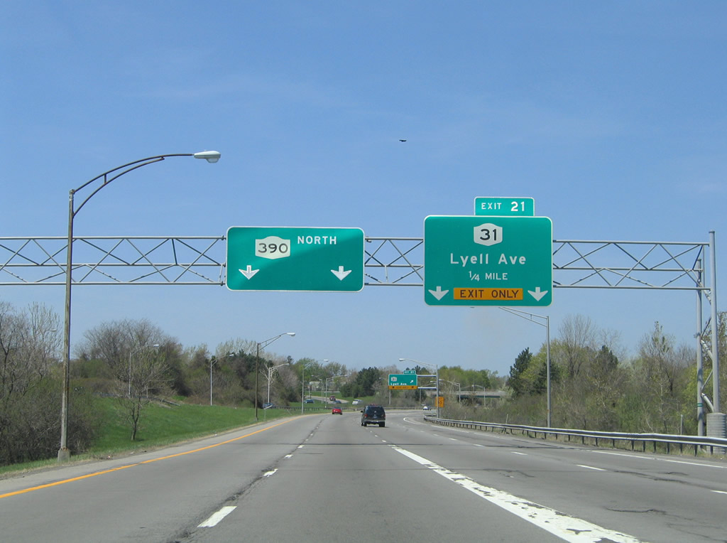 |
New York 390 leaves the confluence with Interstates 390 and 490 and immediately enters the parclo interchange with New York 31 (Exit 21). New York 31 follows Lyell Avenue east to Broad Street in Rochester. Photo taken 05/10/05. |
 |
Drivers joining New York 390 from Interstate 490 east merge onto the freeway beyond the Exit 21 gore point for New York 31. New York 31 leaves Lyell Avenue for Spencerport Road to North Gates. The state route travels 208.74 miles overall between Niagara Falls and Vernon Center. Photo taken 05/10/05. |
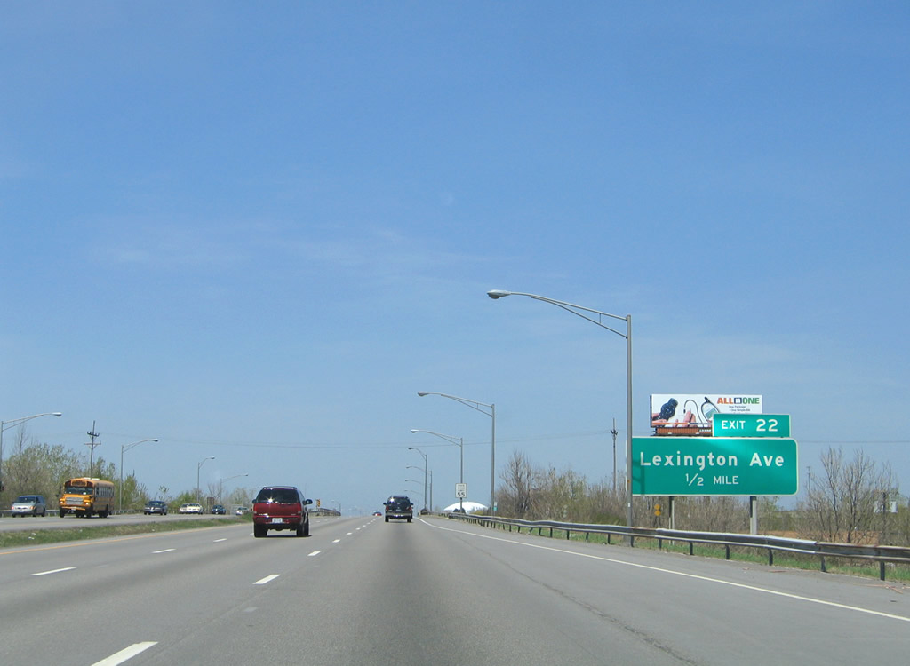 |
Lexington Avenue interchanges with New York 390 at Exit 22. Photo taken 05/10/05. |
 |
Northbound reassurance marker posted as New York 390 crosses the Erie Canal. Photo taken 05/10/05. |
 |
Lexington Avenue travels east from New York 390 and a trumpet interchange to the Kodak (industrial) Park (former Kodak Distribution Center) and Lake Avenue. Photo taken 05/10/05. |
 |
Ridgeway Avenue (Monroe County 111) meets New York 390 at the Exit 23 parclo interchange. The east-west arterial skims the north side of Kodak Park en route to New York 104 (Ridge Road) at Lake Avenue. Photo taken 05/10/05. |
 |
Exit 23 departs New York 390 for Ridgeway Avenue. Ridgeway Avenue continues west to South Greece and New York 386 (Elmgrove Road). Photo taken 05/10/05. |
 |
New York 390 (Rochester Outer Loop) veers northeast over Weilland and Latona Roads on the one-half mile approach to Exits 24A/B, New York 104 (Ridge Road). New York 390 reduces from six to four lanes northbound at this interchange. The interchange also represents the original end of the New York 47 freeway. Photo taken 05/10/05. |
 |
Another reassurance shield posted for New York 390, situated between Latona Road (Monroe County 152) and Exit 24A. Photo taken 05/10/05. |
 |
New York 104 follows West Ridge Road east through the industrial northwest side of Rochester to Maplewood Park. East of the Genesee River, the arteiral upgrades intoa full freeway to New York 590 (Sea Breeze Expressway). Photo taken 05/10/05. |
 |
Exit 24A departs New York 390 north for New York 104 (West Ridge Road) east. New York 104 represents the pre-1972 designation of U.S. 104. The state route travels 182.41 miles overall between Niagara Falls and Williamstown. Photo taken 05/10/05. |
 |
Construction underway at the time of this photograph involved replacing the New York 104 (West Ridge Road) bridges above New York 390. A temporary pedestrian overpass was constructed as well. Photo taken 05/10/05. |
 |
A look at the since-removed button copy overhead for Exit 24B, New York 104 (West Ridge Road) west. New York 104 continues through Greece and West Greece on its exit of the Rochester area. Photo taken 05/10/05. |
 |
New York 390 is designated the Assemblyman Roger J. Robach Memorial Lakeway between New York 104 and the northern terminus at Lake Ontario State Parkway. Photo taken 05/10/05. |
 |
The New York 104 northbound on-ramp forms an exit-only lane for Exit 25 (Vintage Lane) along New York 390 north. Photo taken 05/10/05. |
 |
One half mile south of the Exit 25 parclo interchange with Vintage Lane. Vintage Lane travels east to Mt. Read Avenue, becoming Dorsey Road through to New York 18 (Dewey Avenue) in eastern Greece. Photo taken 05/10/05. |
 |
Exit 25 departs New York 390 north for Vintage Lane. Westward, the surface road continues to English Road Park and Pond Road in Greece. Mill Road continues the road west to New York 261 (Manitou Road). Photo taken 05/10/05. |
 |
Passing under English Road (Monroe County 109) on New York 390 northbound. Photo taken 05/10/05. |
 |
New York 18 follows Latta Road west from Mount Read and Dewey Avenue to New York 390 at Exit 26. Photo taken 05/10/05. |
 |
New York 18 continues west through Greece via Latta Road to a brief overlap with New York 261 along Manitou Road. The 87.28-mile route begins in Rochester at New York 104 and ends at New York 104 in Lewiston. Photo taken 05/10/05. |
 |
North of New York 18, New York 390 defaults onto the Ontario State Parkway at its northern terminus. Like all state parkways in New York state, commercial vehicles are prohibited. Therefore commercial traffic must depart the Rochester Outer Loop for New Y ork 18 (Exit 26). Photo taken 05/10/05. |
 |
A set of signs reinforce the commercial vehicle prohibition for New York 390 north of New York 18 (Latta Road). Photo taken 05/10/05. |
 |
A trumpet interchange facilitates movements between New York 390 north and the Lake Ontario State Parkway. The parkway represents a limited access highway between the Charlotte section of north Rochester and Hamlin Beach along Lake Ontario. Photo taken 05/10/05. |
 |
One half mile south of the Exit 27A/B ramp split to Lake Ontario State Parkway on New York 390 north. Lake Ontario State Parkway serves northern reaches of the town of Greece in either direction from the Rochester Outer Loop end. Photo taken 05/10/05. |
 |
Exit 27A leaves New York 390 north for Lake Ontario State Parkway east. The parkway ends at Lake Avenue and Pattonwood Drive. Westbound the parkway ends at Lakeside Beach State Park with a roadway stub leftover from an unconstructed extension west to Niagara Falls. Photo taken 05/10/05. |
Page Updated August 24, 2009.
|
About Contact Glossary |
In The News Testimonials Interstate Guide |
Social Media:
 |
|
© 2000-23 AARoads.com | All Rights Reserved | Privacy Policy / Terms of Use
|
||