An intrastate route, U.S. 201 runs north from Brunswick through west central Maine to Waterville, Skowhegan and the Canadian province of Quebec north of Moose River.
|
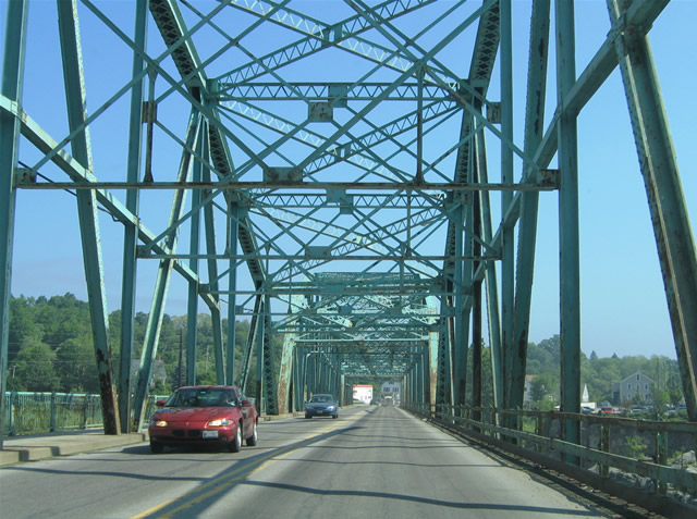
| U.S. 201's first reassurance marker appears alongside Route 24 at the Androscoggin River truss bridge. The two lane span joins Downtown Brunswick with Main Street through Topsham. 06/28/05 |
|
| Traveling across the Androscoggin River on U.S. 201/Route 24 (Main Street) northbound. 06/28/05 |
|
| The Androscoggin Rive flows east from Auburn and Lewiston into Merrymeeting Bay and the Kennebec River. The river also separates Brunswick and Cumberland County from Topsham and Sagadahoc County across U.S. 201. 06/28/05 |
|
| Within Topsham, U.S. 201/Route 24 (Main Street) leave the Androscoggin River and near their split at Elm Street. Route 24 turns eastward toward Bowdoinham. U.S. 201 maintains a northward trajectory to the commercial district of Topsham, meeting Route 196 (New Lewiston Road) near the exchange with I-295 (Exit 31). 06/28/05 |
|
| U.S. 201 (Main Street) northbound after its split from Route 139 (Western Avenue) in the town of Fairfield. U.S. 201 meets I-95 at a parclo interchange (Exit 133) in three quarters of a mile. Both highways leave one another for good beyond the exchange. U.S. 201 continues northward to Skowhegan; I-95 turns northeast to Pittsfield and Newport. 06/27/05 |
|
| Southbound along Main Street in Fairfield at Route 139 (Western Avenue). Route 139 enters town from Fairfield Center and an interchange (Exit 132) with I-95 to the west. U.S. 201 south / Route 139 east share a two block overlap to Route 11/100. Route 139 travels between Norridgewock and Winterport overall. 06/27/05 |
|
| Once in Topsham, U.S. 201 (Main Street) merges with Route 24 (Elm Street) for its final half mile. U.S. 201/Route 24 follow Main Street south to the Androscoggin River truss bridge into Brunswick. An end shield for U.S. 201 appears at the span. 06/28/05 |
|
| Spanning the Androscoggin River on U.S. 201/Route 24 (Main Street) south. The river represents the border between Sagadahoc and Cumberland Counties as well as the town line between Topsham and Brunswick. 06/28/05 |
|
| Spanning the Androscoggin River on U.S. 20/Route 24 (Main Street) south. The river represents the border between Sagadahoc and Cumberland Counties as well as the town line between Topsham and Brunswick. 06/28/05 |
|
| U.S. 201/Route 24 emerge from the truss bridge at the modified diamond interchange with U.S. 1. U.S. 1 follows a freeway from Mill Street in Brunswick eastward to Bath. U.S. 201 ends here; Route 24 continues south via Maine Street through Downtown Brunswick to Bath Road at Bowdoin College. 06/28/05 |
|
| Route 24 (Maine Street) southbound spans the U.S. 1 freeway between the north and southbound ramps. A wide boulevard carries the state route through the Brunswick central business district. Joining Brunswick with I-295 and Freeport to the west and Cooks Corner and Bath to the east, U.S. 1 travels along the Androscoggin River. 06/28/05 |
Page Updated 02-01-2015.