|
| The I-71/75 interchange near the town of Walton was put into the limelight just after it opened in 1969 when TV star Fess Parker announced the construction of a huge theme park modeled after Disneyland. It never opened, due to financial problems. 06/04/08 |
|
| The first exit north of where I-71/75 combine is at Richwood, once a small farming town. Following work on I-75 in the late 80s, Richwood started to develop rapidly. Construction of the huge Triple Crown subdivision in the town got underway in 1990/1991. 06/04/08 |
|
| With Triple Crown opening in 1992, traffic counts along KY 338 doubled by 2001. 06/04/08 |
|
| The Richwood interchange also has three truck stops, a product of it being the first junction after I-71/75 converge. Residents generally have to contend with large trucks to access the freeway. It was announced in 2004 that the exchange would be rebuilt with more lanes and longer turning zones. Work had yet to begin by 2008. 06/04/08 |
|
| I-71/75 remains very wide and busy through the southwestern Cincinnati metro area. 06/04/08 |
|
| The succeeding exit is for KY 536 (Mount Zion Road). A $23 million expansion project underway in 2006/2007 addressed growing suburban traffic along Mount Zion Road. 06/04/08 |
|
| KY 536 runs west to the town of Union, a suburban community mostly consisting of tract housing. The road is usually considered when the idea of an east/west arterial or freeway is brought up. The proposed route would connect all three Northern Kentucky counties. 06/04/08 |
|
| I-71/75 enters the city of Florence here. The community is generally considered to be the gateway to the "upland south", which is that part of the southern US north of the "deep south". The town has a well known water tower with the phrase "Florence Y'all" painted on it. The story goes that the mall donated land for the tower which was painted "Florence Mall". When the construction of the mall was delayed, and the city had to paint over the water tower, they simply changed one letter and added an apostrophe. 06/04/08 |
|
| US 42/127 is the next interchange, and is the main route into Florence. Immediately to the west of the interstate here is Northern Kentucky's largest shopping center, the Florence Mall. 06/04/08 |
|
| I-71/75 northbound at US 42/127. 06/04/08 |
|
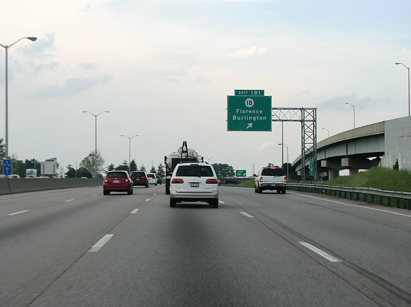
| The wye interchange with ramps for Florence Mall opened in November 1990 in time for the holiday shopping season. The ramps provide direct access to the mall from I-71/75 south and to I-71/75 north. A diamond interchange immediately follows with KY 18 at Exit 181. 06/04/08 |
|
| KY 18 is locally known as Burlington Pike. The road runs west of here, just south of the airport, to the town of Burlington. Unincorporated Burlington has about 10,000 residents. 06/04/08 |
|
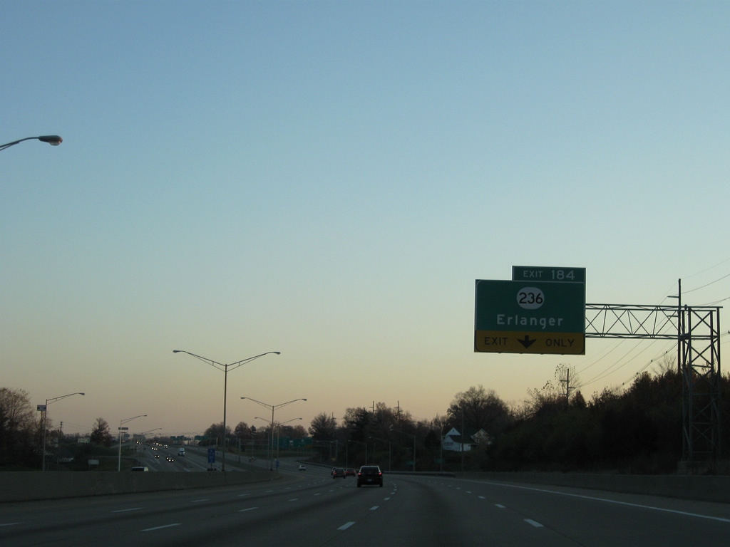
| Erlanger is located in Kenton County, and the exit at KY 236 is the first for the community. Kenton is the middle of the three Northern Kentucky counties located in the Cincinnati metro area. Erlanger is noted for its police forcing out of town drivers to pay cash for services rendered in accidents that occur here. 06/04/08 |
|
| The entrance ramp from KY 18 (Burlington Pike) forms an auxiliary lane to Exit 182 for KY 1017. KY 1017 lines Turfway Road south to U.S. 25/42 (Dixie Highway) and north to KY 236 (Donaldson Road). 11/14/04 |
|
| I-71/75 northbound at Turfway (Exit 182), there is even more retail at this exit. KY 1017 (Turfway North) connects the freeway with Turfway Park race course. 11/14/04 |
|
| I-71/75 span KY 1017 (Turfway Road) ahead of the parclo interchange (Exit 184) with KY 236 (Commonwealth Avenue / Donaldson Highway). 11/14/04 |
|
| The Erlanger exit and this part of freeway was widened and rebuilt from 1999 to the fall of 2001. The $30 million project included repaving and adding extra lanes to ramps as well. This was the last portion of I-71/75 in Northern Kentucky rebuilt as the state updated the road from its 1961 design to more modern standards. 06/04/08 |
|
| KY 236 (Donaldson Highway) straddles eastern reaches of Cincinnati-Northern Kentucky International Airport (CVG), serving air cargo interests of the facility. 11/08/09 |
|
| Entering Kenton County and the city of Erlanger along I-71/75 north. Exit 184 was the first of three cloverleaf interchanges originally built for the freeway tandem. All have been redesigned into diamonds, with the exception of the loop ramp from I-71/75 south to KY 236 east. 11/08/09 |
|
| A two lane ramp departs I-71/75 north at Exit 184 to KY 236. KY 236 follows Commonwealth Avenue east into Erlinger and Stevenson Road from U.S. 25/42 (Dixie Highway) to KY 1303. Exit 185 ahead with I-275 east provides connections to I.471 north and the city of Newport. 11/14/04 |
|
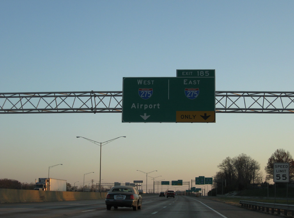
| I-275 is the world's longest Beltway. Planning for the road began as early as 1953 but work did not begin until April of 1968. The majority of the route in Kentucky, including the stack here, opened in December of 1977. The beltway was totally completed December 19, 1979 when the eastern Ohio River bridge opened. 11/08/09 |
|
| Traffic from KY 236 at Erlanger separates from the I-71/75 mainline to the junction with Interstate 275. 11/08/09 |
|
| Two lanes separate for I-275 from I-71/75 north at Exit 185. The adjacent entrance ramp from KY 236 splits into ramps for both Cincinnati and I-275 nearby. 06/04/08 |
|
| Interstate 275 west continues to CVG Airport, Hebron and Lawrencesburg, Indiana. Eastbound I-275 stays south of Newport and Fort Thomas en route to Mount Washington and Milford, Ohio. 11/14/04 |
|
| Views of the stack at the Cincinnati Beltway. This is the only symmetrical stack interchange in the entire Cincinnati metropolitan area. 06/04/08, 11/08/09 |
|
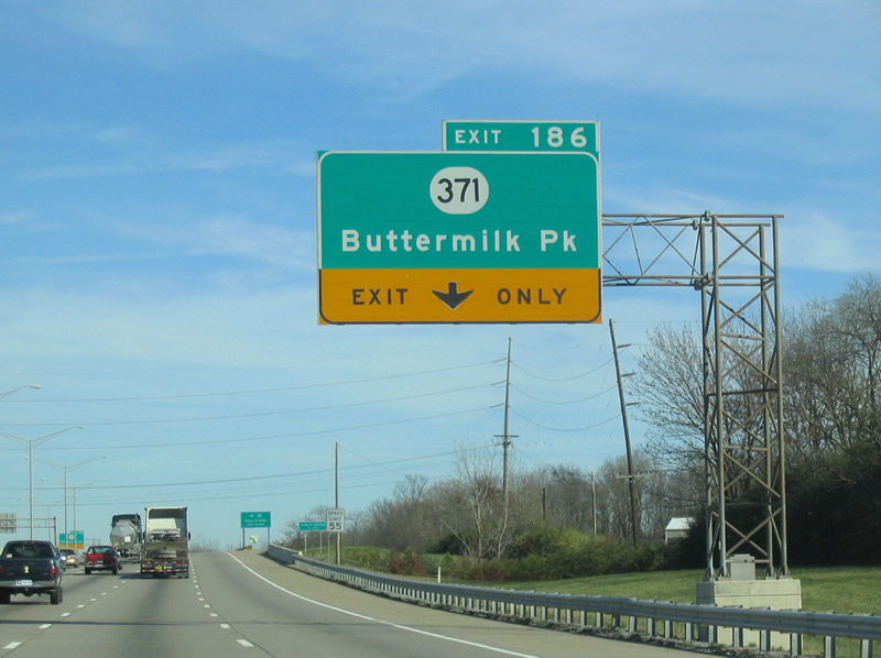
| Passing under the Interstate 275 mainline, I-71/75 advances 1.25 miles to Exit 186 for KY 371. KY 371 meanders east to Fort Mitchell and KY 17 (Madison Pike) and west to Villa Hills and KY 8 (River Road). 11/14/04 |
|
| I-71/75 reassurance markers posted where the freeway leaves Interstate 275 and Erlanger. 11/14/04 |
|
| An auxiliary lane opens along I-71/75 north from I-275 to the parclo interchange (Exit 186) with KY 371 (Buttermilk Pike). 11/14/04 |
|
| Traffic builds as the interstate heads into the city. This view looks north at the Buttermilk Pike exit, so named because it ran past many dairy farms in the old days. 06/04/08 |
|
| Kentucky put up signs like this in the mid 2000s as part of their "TACT" program, which stands for Targeting Aggressive Cars and Trucks. The signs remind drivers to leave more space on the freeways. 06/04/08 |
|
| Mid-rise office blocks sit to the west as collector distributor lanes enter from I-275 on the right side of the freeway. 06/04/08 |
|
| US 42/127 return from Florence to the east alongside U.S. 25 at Exit 188. 06/04/08 |
|
| US 25 begins in Brunswick, Georgia near the Atlantic Ocean, and ends just north of here at the Ohio state line on the C. W. Bailey Bridge. 11/14/04 |
|
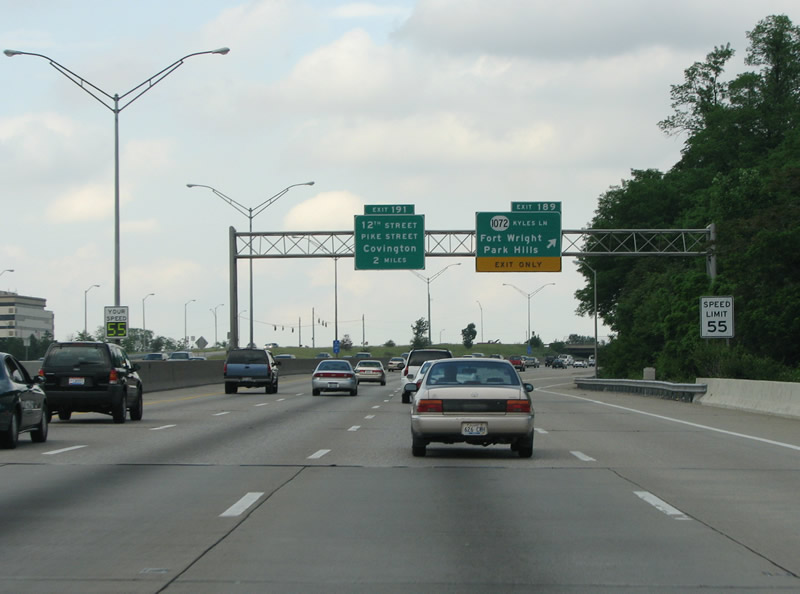
| Truckers are advised of the forthcoming "Cut in the Hill", where I-71/75 drop steeply from the Park Hills area into Covington. 11/08/09 |
|
| Fort Wright has about 6,000 people and is an historic suburb of Cincinnati. The town contains the Ramage Civil War museum, formerly a fortification called Hooper Battery. 11/08/09 |
|
| I-71/75 reassurance markers in Fort Wright. 06/04/08 |
|
| Kyles Lane runs south from the Dixie Highway to the Madison Pike at Fort Wright.
Clearview-based signs replaced all Exit 191 signs between 2008 and 2009. 06/04/08, 11/08/09 |
|
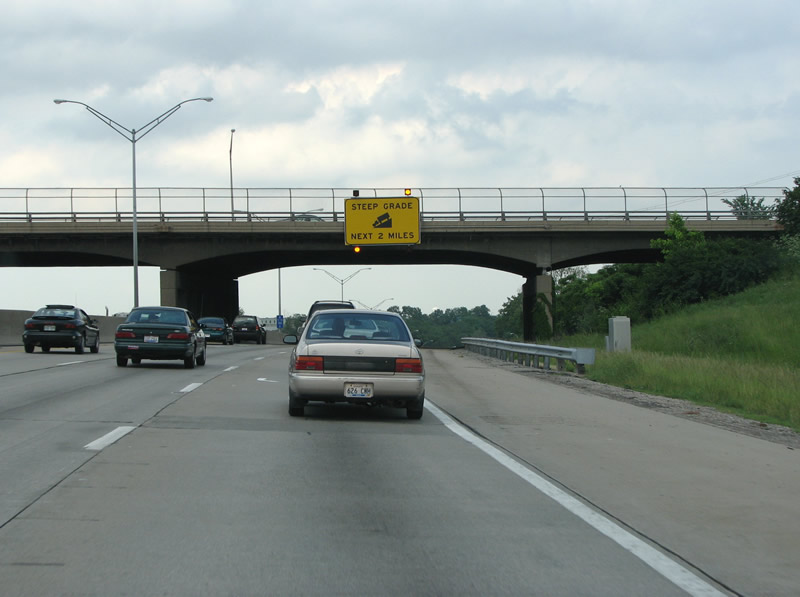
| This sign warns truckers of the danger ahead, a steep grade as the road dives into the Ohio River valley. 06/04/08 |
|
| The final confirming markers along the I-71/75 northbound overlap, posted south of Park Hills. 11/08/09 |
|
| Covington is Kentucky's 5th most populous city, and sits immediately across the river from Cincinnati, Ohio. The city has about 50,000 people and a skyline of its own, including the architecturally unique Ascent at Roebling's Bridge. 06/04/08 |
|
| This stretch of road is derisively known as "Death Hill", in 1994 it reopened with three northbound lanes and 4 southbound. The freeway climbs 370 feet from the river to Fort Wright, and includes several sharp curves and steep grades. Within six years of its opening in 1962, 23 people died in wrecks on the stretch of roadway. In 1966, nine people died in wrecks along this stretch, earning it its morbid nickname. 06/04/08 |
|
| The last exits in Kentucky run east into downtown Covington and further to Newport. Both towns have historic downtowns and river fronts.
Sign changes were made for Exit 191 when the city of Covington renamed 12th Street to 12th Street / Dr. Martin Luther King, Jr. Boulevard in 2007. 11/14/04, 11/08/09 |
|
| Continuing the steep descent into Covington along I-71/75 north. The "Death Hill" nickname came out of a bad reputation, but earlier this roadway went through the hill at a spot called "Cut in the Hill". That name was beginning to take over from "Death Hill" after the road was rebuilt but the safety of this spot was called into question again in 2006 when three big rigs crashed into each other. 11/08/09 |
|
| The skyline of Cincinnati is stunning as it suddenly appears around a knob overlooking the Ohio River valley. The view makes this three mile section of interstate one of the best urban drives in the nation. The skyline is topped out by the 49-story Carew Tower, which opened in 1931. Cincinnati is home to the corporate headquarters of companies like Kroger, Macy's/Bloomingdale's, and Proctor and Gamble - all three of which have towers downtown. 11/14/04, 06/04/08 |
|
| Exit 191 departs I-71/75 northbound as it flattens out from Cut in the Hill at the split diamond interchange with W 12th Street / Dr. Martin Luther King, Jr. Boulevard (KY 1120). KY 1120 travels east through Covington and across the Licking River to 11th Street in Newport. The state highway connects with U.S. 27 and Iz471 in the adjoining city. Pike Street carries U.S. 25-42-127 north to Main Street through Covington. 11/14/04, 11/08/09 |
|
| The three mile stretch of I-75 from Fort Mitchell to the Ohio River was completely rebuilt from the Spring 1990 to December 1994. The project was supposed to be completed in the Fall of 1992 but was extended almost two years because of a strike and environmental violations. Additionally, work had to be started over several times because of concrete poured incorrectly.
Exit 192 departs for KY 8 (5th Street) east into Downtown Covington. KY 8 utilizes a one way couplet of 4th and 5th Streets east to a crossing of the Licking River into Downtown Newport. 11/08/09 |
|
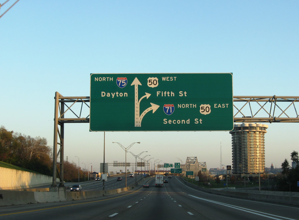
| Dayton debuts as a control point here, even before Cincinnati. US 50, one of the nation's most important cross country US highways, ties in from the 6th Street Expressway to the west and an overlap with Interstate 71 east to Fort Washington Way. 11/08/09 |
|
| Downtown Cincinnati exits are signed here as the ramp to I-71 north / U.S. 50 (Fort Washington Way) east includes a connection onto 2nd Street east. Exit 1 C quickly follows from the I-75 mainline to the intersection of 5th Street and Central Avenue (U.S. 27-42-52-127). 11/08/09 |
|
| Beginning the ascent onto the Brent Spence Bridge along I-71/75 north. Visible to the northeast is the C.W. Bailey Bridge taking U.S. 25-42-127 across the Ohio River. U.S. 25 ends at the state line, while U.S. 42/127 continue north to 3rd Street east to Central Avenue (U.S. 27/52). 11/08/09 |
|
| I-71 and I-75 partition at the north end of the Brent Spence Bridge. I-71 continues northeastward through Ohio's three largest cities to Interstate 90 in Cleveland. 11/08/09 |
|
| The Brent Spence Bridge is a double decker bridge that takes I-71 and I-75 over the Ohio River, just to the southwest of downtown Cincinnati. The bridge opened in November 1963 with three lanes in each direction. In 1986 the shoulders were eliminated and the bridge was repainted with four lanes each way. 11/14/04 |
|
| The bridge was named for Kentucky congressman Brent Spence, who retired in 1962. As the bridge opened only three days after President Kennedy's assassination, Spence implored Kentucky governor Bert T. Combs to rename the bridge after the slain President. Combs refused to rename the bridge, and it bears Spence's name to this day. 11/08/09 |
|
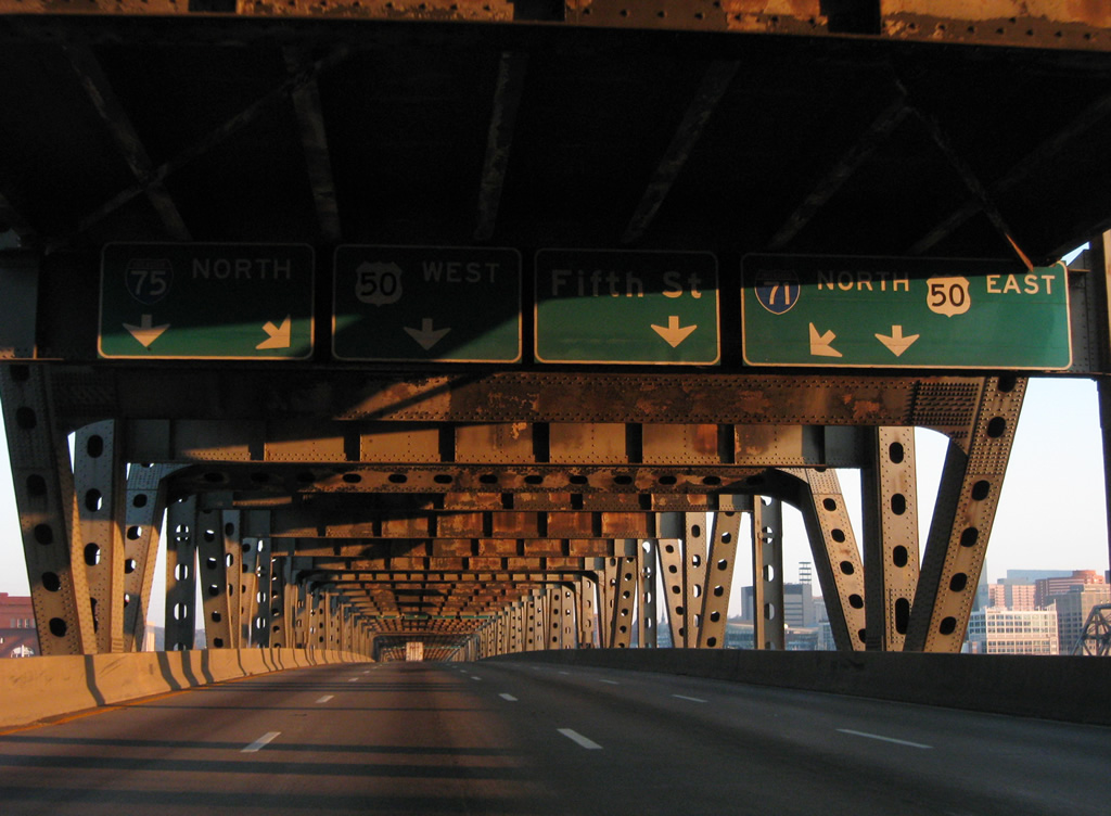
| Traveling north on the lower deck of the Brent Spence Bridge, a series of overheads precede the separation of I-75 north to Dayton from I-71/U.S. 50 east along the Cincinnati Riverfront with connections to 2nd Street for Paul Brown Stadium; U.S. 50 (6th Street) west along the Ohio River; Fifth Street east to U.S. 22, 27, 42, 52, 127 and the central business district. 11/08/09 |
|
| I-71/U.S. 50 travel east along Fort Washington Way from the next exit. U.S. 50 leaves the freeway for Columbia Parkway to the Mt. Adams, Columbia-Tusculum and Mt. Lookout neighborhoods in eastern Cincinnati. Interstate 71 curves northeast to Norwood and Columbus. 11/08/09 |
|
| 2nd Street constitutes a frontage street along I-71/U.S. 50 by Paycor Stadium (home of the NFL Cincinnati Bengals) and Great American Ballpark (home of the MLB Cincinnati Reds). 5th Street flows east as SR 264 from the 6th Street Expressway to Central Avenue. SR 264 ends there as 5th Street continues to the Duke Energy Convention Center and Cincinnati central business district. 11/08/09 |
|
| I-75 turns northwesterly from I-71 through the West End neighborhood of Cincinnati on the four miles leading to Camp Washington and the westbound beginning of Interstate 74. U.S. 50 west follows a ramp nearby to make the connection from Fort Washington Way to the 6th Street Viaduct. U.S. 50 west follows the Ohio River west to Queensgate and Riverside in west Cincinnati. 11/08/09 |
Page Updated 03-08-2012.


 North
North