|
| Leading away from SH 71, the next exit along IH 35 north is for Oltorf Street. 09/27/06 |
|
| Exit 232A departs IH 35 north for Oltorf Street to the Greater South River City and East Riverside - Oltorf communities of Austin. 09/27/06 |
|
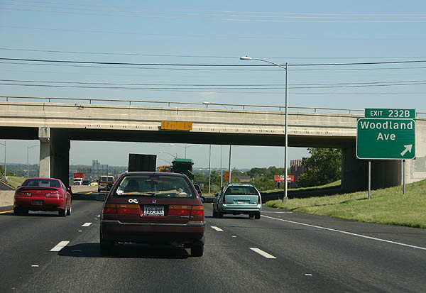
| Advance signage for Exit 232B, Woodland Avenue. 09/27/06 |
|
| One of the few US 290 shields on the overlapped section of IH 35. 09/27/06 |
|
| Exit 232B connects IH 35/U.S. 290 with the Travis Heights and Riverside neighborhoods south of the Colorado River. 09/27/06 |
|
| One half mile south of Exit 233 to Riverside Drive. 09/27/06 |
|
| The entrance ramp from Oltorf Street forms an auxiliary lane along IH 35 north to Exit 233. The freeway curves northward across the Colorado River beyond the upcoming off-ramp. 09/27/06 |
|
| Exit 233 joins the IH 35 frontage road ahead of East Riverside Drive. Riverside Drive comprises a commercial arterial southeast to Pleasant Valley. West from the freeway, Riverside Drive continues to SL 343 (Lamar Boulevard) at Butler Shores Park. 09/27/06 |
|
| Spanning the Colorado River, IH 35 reaches the off-ramp (Exit 234A) to Holly Street for Town Lake and the Rainey Street Historic District. 09/27/06 |
|
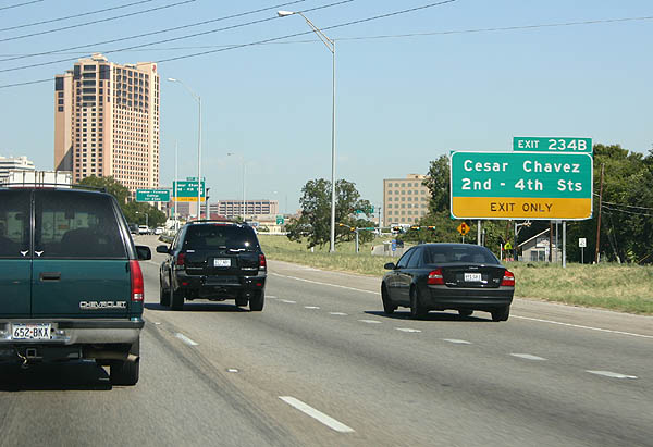
| Advance signage for Cesar Chavez Street, 2nd Street and 4th Street. Exit 234B connects IH 35 with Downtown Austin and the bars along 4th Street. 09/27/06 |
|
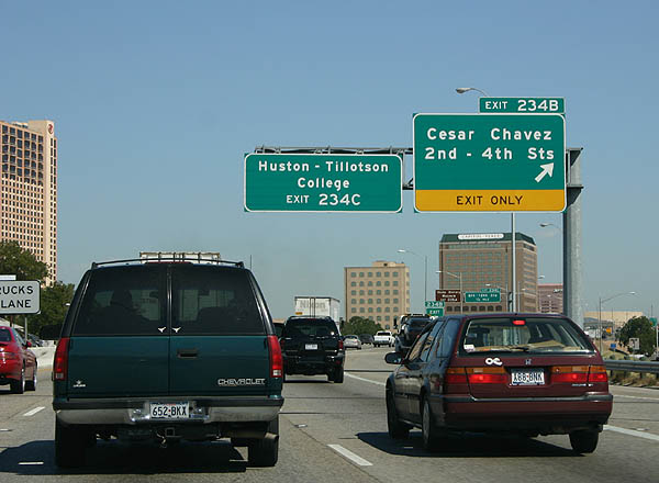
| Exit 234B departs IH 35/U.S. 290 north for Cesar Chavez, 2nd and 4th Streets for the Austin Convention Center and Huston-Tillotson University. 09/27/06 |
|
| IH 35/U.S. 290 proceed a quarter mile north to Exit 234C for 6th and 12th Streets. The bars and live music venues that Austin is known for are found along 6th Street. The succeeding ramp for MLK Boulevard leads to the Bullock Texas State History Museum in north Downtown. 09/27/06 |
|
| A split diamond interchange (Exit 234C) joins IH 35/U.S. 290 with the blocks between 6h and 9th Street along the east side of Downtown. A similar ramp layout follows between 14th Street and Martin Luther King, Jr. Boulevard at Exit 235A 09/27/06 |
|
| Exit 235A serves the University of Texas at Austin, 15th Street, MLK, Jr. Boulevard, and the Texas State Capitol. The dome at the state capitol is larger than the one at the U.S. Capitol in Washington, DC. 09/27/06 |
|
| IH 35 separates into a double-decked section northbound beyond the Martin Luther King, Jr. Boulevard overpass. The inside lanes form the lower deck, which leads to Exits 235B and 236 for the LBJ Presidential Library. 09/27/06 |
|
| The lower deck links IH 35/U.S. 290 with Manor Road and Dean Keeton, 32nd and 38 1/2 Streets. The upper roadway (Exit 237A) continues to Airport Boulevard, 51st Street and Cameron Boulevard. 09/27/06 |
|
| Exit 235B departs from the IH 35 lower roadway just beyond the separation with the upper roadway for Manor Road. The succeeding slip ramp (Exit 236) leaves for Dean Keeton Street and the adjacent LBJ Presidential Library. 09/27/06 |
|
| Manor Road links IH 35/U.S. 290 with Darrell K Royal - Texas Memorial Stadium at UT-Austin to the west and the French Place neighborhood to the east. 09/27/06 |
|
| IH 35 between Manor Road and Airport Boulevard was double-decked between 1971 and 1975. The lower level remains as built in 1962, with outdated geometry, short exit ramps and routine congestion. 09/27/06 |
|
| Looking north from the Manor Road overpass at the double-decked section of IH 35/U.S. 290. March 2000 |
|
| Exit 236 serves Dean Keeton Street west to UT-Austin, 32nd Street to Central Austin and 38 1/2th Street to French Place. 09/27/06 |
|
| The lower roadway advances a half mile north to Exit 237A for Airport Boulevard, Cameron Street and 51st Street. 09/27/06 |
|
| The IH 35 double-deck section was added due to lack of available right-of-way between UT-Austin and Oakwood Cemetery. 09/27/06 |
|
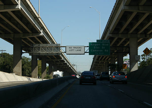
| Exit 237A comprises a slip ramp to the IH 35 east frontage road ahead of Airport Boulevard. Airport Boulevard serves the Mueller Community, a housing development built at the site of former Robert Mueller Municipal Airport. 09/27/06 |
|
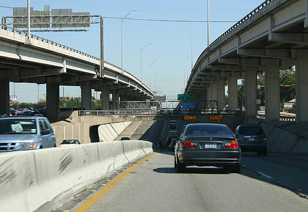
| Exit 237B succeeds beyond the merge of the lower and upper IH 35 roadways for 51st Street and Cameron Boulevard. This exit is not accessible from the lower level due to short merging space. 51st Street runs west to Hyde Park and east to the Mueller Community, Cameron Boulevard branches northeast to Windsor Park and U.S. 290. 09/27/06 |
|
| U.S. 290 parts ways with IH 35 north at the ensuing interchange with RM 2222 (Exits 238A/B). U.S. 183 follows in one mile at Exits 239/240. 09/27/06 |
|
| Exit 238A connects IH 35 northbound with RM (UR) 2222. RM (UR) 2222 extends Koening Lane northwest from Spur 69 at Lamar Boulevard (old U.S. 81) 10.77 miles to RM (UR) 620. Spur 69 overlays Koening Lake 1.06 miles west from the exchange with the departing U.S. 290. 09/27/06 |
|
| U.S. 290 east splits with IH 35 north along a high speed flyover (Exit 238B) onto a freeway east to U.S. 183. U.S. 290 partitions with the SH 290 tolled express lanes from there east to the city of Manor. 09/27/06 |
|
| Exit 239 leaves IH 35 northbound within the four level interchange with U.S. 290 east and SS 69 (Koenig Lane) west for St. Johns Avenue and Anderson Lane along the U.S. 183 freeway. 09/27/06 |
|
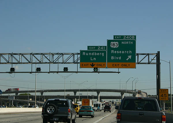
| Exit 240B departs IH 35 northbound next for U.S. 183 north. U.S. 183 (Research Boulevard) comprises a freeway north along a commercial corridor through north Austin. 09/27/06 |
|
| Northbound IH 35 at the flyover (Exit 240B) for U.S. 183 (Research Boulevard) to the northern suburbs of Austin and Lampasas. 09/27/06 |
Page Updated 07-07-2019.

 North
North