|
| IH 410 was expanded to ten overall lanes, including auxiliary lanes, leading east to Loop 345 (Fredericksburg Road) at Balcones Heights. 02/18/06 |
|
| Advance signs for the systems interchange (Exit 16) with IH 10/U.S. 87 precedes the off-ramp (Exit 15) for Spur 345. 02/18/06 |
|
| SL 345 along Fredericksburg Road is former U.S. 87. 02/18/06 |
|
| The half diamond interchange (Exit 15) with SL 345 (Fredericksburg Road) lies just west of IH 10 by the Wonderland of Americas shopping mall. 02/18/06 |
|
| Lighted arrows on sign bridges at Exit 16 (Interstate 10) are lane guidance from San Antonio’s intelligent traffic system, Transguide. 02/18/06 |
|
| Ramps for IH 10 and US 87 separate from IH 410 at the Fredericksburg Road overpass. 02/18/06 |
|
| Built in 1960, a directional cloverleaf interchange with left side ramps originally joined IH 10/IH 410 at Balcones Heights. Construction in 2005/06 rebuilt the exchange into a five-level interchange. 02/18/06 |
|
| Completely past IH 10/U.S. 87, the next exits along IH 410 east are for Vance Jackson Road and Jackson-Keller Road. 02/18/06 |
|
| Exit 17B joins IH 410 east with Vance Jackson Road and the North Central neighborhood of San Antonio. 02/18/06 |
|
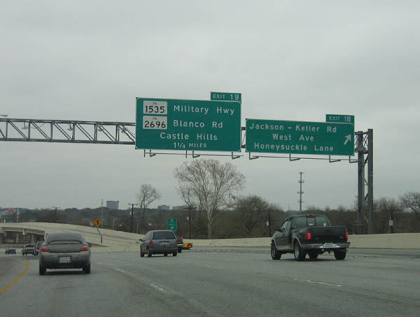
| Exit 18 serves Jackson-Keller Road, West Ave and Honeysuckle lane. 02/18/06 |
|
| FM (UR) 1535 travels northward to Camp Bullis. FM (UR) 2696 travels north to Loop 1604, then to the Comal County line. 02/18/06 |
|
| IH 410 enters the city of Castle Hills ahead of Exit 19 for FM 1535 (Military Highway) and FM 2696 (Blanco Road) north. 02/18/06 |
|
| The succeeding exit beyond FM 2696 (Blanco Road) is with San Pedro Avenue (former Spur 537). Spur 537 along San Pedro Avenue represented the original route of U.S. 281 through north San Antonio. 02/18/06 |
|
| Construction reconfigured Exit 18 by realigning the southbound ramp from FM 1535 to a T intersection with the IH 410 frontage road. A direct ramp to Blanco Road was subsequently removed. 02/18/06 |
|
| A diamond interchange (Exit 20) joins IH 410 with San Pedro Avenue (old U.S. 281). Prior to construction of the systems interchange with U.S. 281 (McAllister Freeway), San Pedro Avenue provided part of the connection between the two freeways. 02/18/06 |
|
| Blanco Road spans IH 410 along the Castle Hills and San Antonio city line. 02/18/06 |
|
| San Pedro Avenue was U.S. 281 prior to the construction of the McAllister Freeway in 1978. A cloverleaf interchange with San Pedro Avenue represented the only connection to U.S. 281 north from IH 410 until 2008. 02/18/06 |
|
| A high speed flyover (Exit 21A) to U.S. 281 (McAllister Freeway) replaced the former exit from IH 410 east to Jones-Maltsberger Road). 02/18/06 |
|
| The flyover ramp (Exit 21B) to U.S. 281 (McAllister Freeway) south from IH 410 east opened to traffic in June 2008. It replaced a frontage road ramp connecting with Airport Boulevard and Wetmore Road. 02/18/06 |
|
| Construction began on the IH 410/U.S. 281 interchange in 2002, 24 years after the completion of the McAllister Freeway. With total costs of the project at about $155 million, funding for the new stack required bond sales. The exchange was omitted from original construction of U.S. 281 due to litigation and delays, which held up release of needed land for the interchange. 12/31/02 |
|
| Eastbound Interstate 410 at Exit 22 to Broadway and Wetmore Road south of San Antonio International Airport (SAT). While Broadway represents the former alignment of U.S. 81 in Downtown San Antonio, it is just a local arterial highway in the northern parts of the city. 12/31/02 |
|
| IH 410 progresses eastward to Windcrest and IH 35, next meeting Nacogdoches Road at Exit 23. Nacogdoches Road parallels IH 35 from Garden Ridge northeast of the city to Alamo Heights and U.S. 281 to the southwest. 12/31/02 |
|
| Harry Wurzbach Road, a divided surface arterial, connects IH 410 at Exit 24 with Terrell Hills and Fort Sam Houston to the south. 12/31/02 |
|
| Crossing over Salado Creek, IH 410 advances toward Exit 25A for Starcrest Drive. 02/18/06 |
|
| Exit 25A leaves IH 410 east for Starcrest Drive, 1.75 miles from IH 35 by Windcrest. 02/18/06 |
|
| Advance signage for Exit 25B, FM (UR) 2252 (Perrin-Beitel Road). FM 2252 arcs northeast to join Nacogdoches Road en route to Garden Ridge and Schertz. 02/18/06 |
|
| Exit 25B to FM 2252 (Perrin-Beitel Road) was reconfigured to depart in unison with Exit 25A ahead of Starcrest Road. 02/18/06 |
|
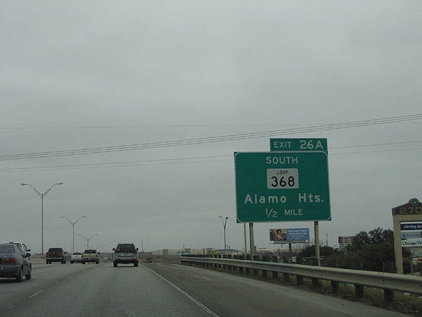
| Loop 368 (Austin Highway) ties into IH 410 just ahead of the exchange with IH 35 at Exit 26A. 02/18/06 |
|
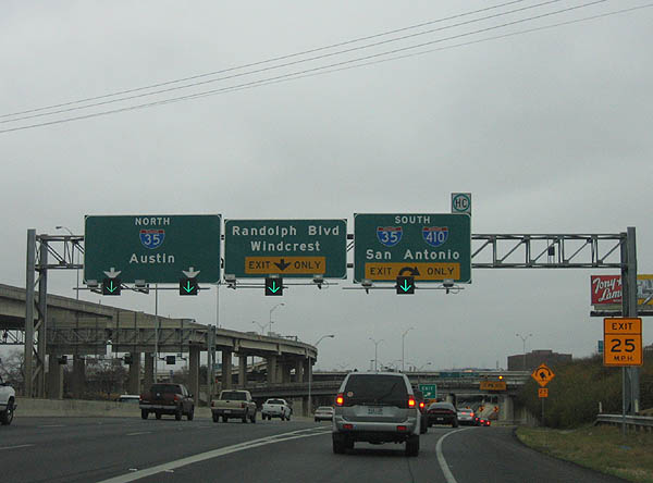
| Loop 368 (Austin Highway) south from IH 410 is former U.S. 81. The beltway mainline defaults onto IH 35 north to Austin along the ensuing stretch. IH 410 east makes a TOTSO (turn off to stay on) movement ahead, combining with IH 35 south at Windcrest. This design dates back to the original construction of Loop 13 which predates IH 410. 02/18/06 |
|
| Exit 26B follows the entrance ramp from SL 368 to Interchange Parkway and the Prologis Park - Perrin Creek business park. 02/18/06 |
|
| Exit 26B parts ways with IH 410 east toward Perrin Creek Drive. Two lanes continue north onto IH 35. Succeeding ramps take IH 410 south back into San Antonio and to Thousand Oaks Drive / Starlight Terrace. 02/18/06 |
|
| IH 410 and IH 35 converge at a modified trumpet interchange along the Windcrest city line. A lone high speed flyover joins IH 35 south with the beltway west. 02/18/06 |
|
| IH 410 east navigates through a slow speed ramp below overpasses for Austin Highway, the Union Pacific Railroad, and the IH 35 frontage road. Long range plans were made to address this outdated interchange in the 2000s. 12/31/02 |
Page Updated 07-04-2019.

 East
East