
U.S. Highway 77 North (Rockdale to Waco)
| U.S. 77 North | |
|---|---|
 |
Just out of Rockdale, US 77 returns to a 2 lane rural roadway. Mileage signs point the way to the next major town, Cameron. Photo taken 01/01/08. |
 |
The first forced stop since Giddings, US 77 joins SH 36 and US 190 to the southeast of Cameron Photo taken 01/01/08. |
 |
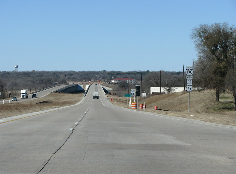
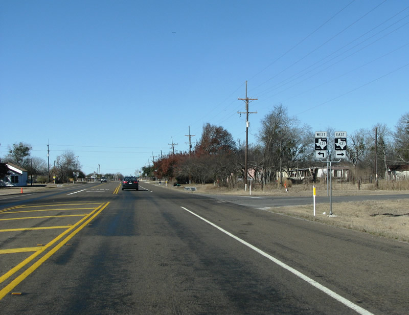
US 77 northbound at US 190 / SH 36. Photo taken 01/01/08. |
 |
A new light will restrict traffic flow along the route, and is probably completely unneccessary for the amount of traffic on these roads. This begins a short 3-route overlap. Photo taken 01/01/08. |
 |
US 190 and SH 36 continue west from Cameron eventually to Temple and IH 35. From there, US 190 becomes a major freeway connecting to Killeen, Fort Hood, and points west. Photo taken 01/01/08. |
 |
The town of Cameron appears on the horizon as the 3-way overlap bridges the Little River on the east side of town. The bridges are brand new in 2007, with rather loud concrete pavement. SH 36 is a major state highway which connects Abilene and IH 20 with the Texas Coast at Freeport. Photo taken 01/01/08. |
 |
A new railroad overpass near downtown Cameron. The three main highways have been routed around the town square to the north, alleviating traffic to the downtown area, as well as siphoning away paying customers from the old mom and pops. Photo taken 01/01/08. |
 |
At Cameron, the short overlap with US 190 and SH 36 ends allowing traffic to continue north to Waco. Photo taken 01/01/08. |
 |
US 77 takes a right turn here, and continues through the town of Cameron. Large victorian mansions are presents in the immediate neighborhoods. Photo taken 01/01/08. |
 |
Leaving Cameron, the countryside changes to more of a cattle and ranching area. US 77 remains light on traffic and services through here. Photo taken 01/01/08. |
 |
At Burlington, FM 1963 turns off. This area of Texas is much less German and was settled more by immigrants from other southern states, especially Tennessee. Thus the kolache and sausage establishments have dissapeared and given way to a more southern look and feel. Photo taken 01/01/08. |
 |
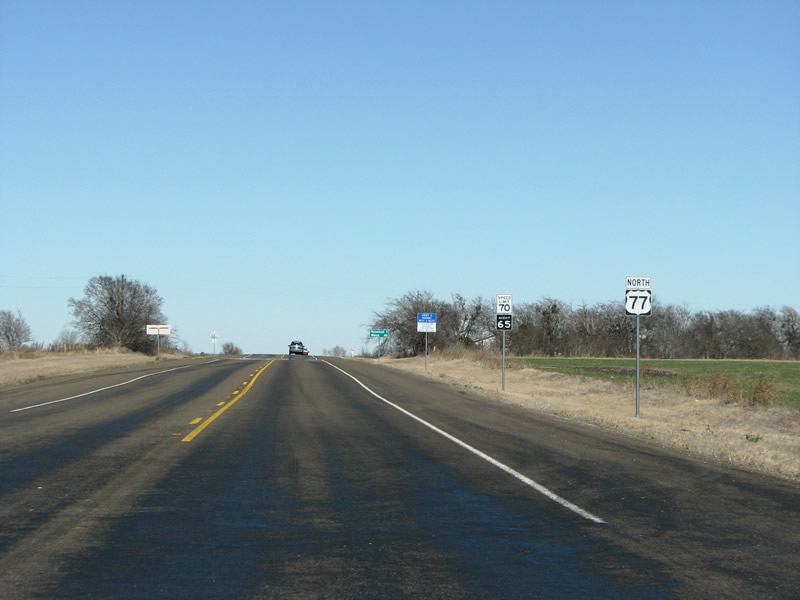
A mileage sign indicates that Waco is a scant 42 miles away, while the next town is Rosebud. Photo taken 01/01/08. |
 |
US 77 enters Falls County. The county was formed in 1850 and named for the falls on the Brazos River. US 77 and SH 6 are the main roads in Falls County, but not the most important ones. IH 35 traverses the extreme western corner, but only for about two miles. Photo taken 01/01/08. |
 |
US 77 northbound at FM 1445. This 9 miles FM road serves the cotton farming community of Clarkson. Photo taken 01/01/08. |
 |
A view of the route near Rosebud. Photo taken 01/01/08. |
 |
US 77 northbound enters Rosebud. The settlement was originally known as Mormon for the large number or Mormon settlers in the area (who were later thrown out by the residents). When the community needed a post office, the local postmaster wanted to name it for the Mullins family and their beautiful roses, but because a Mullins already existed in Texas, the name Rosebud was chosen instead. Photo taken 01/01/08. |
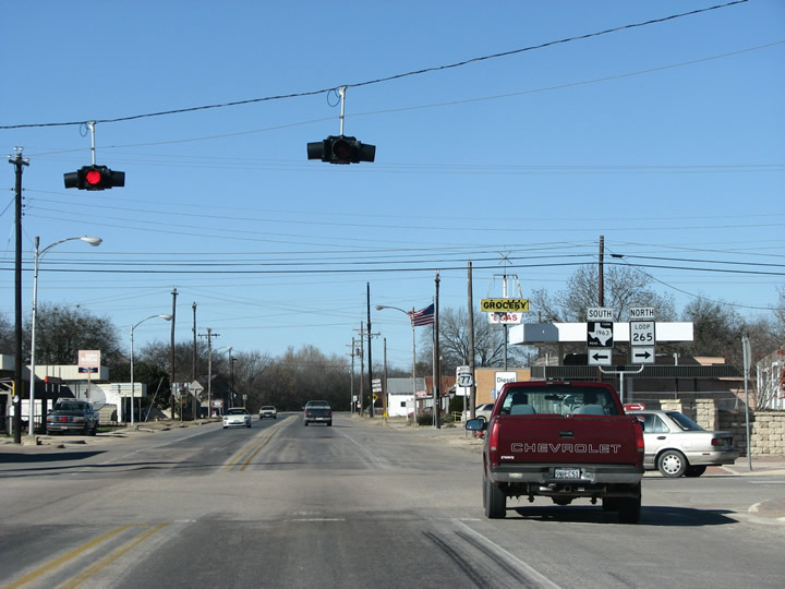 |
At downtown Rosebud US 77 meets Loop 265, the main street, and FM 1963 yet again. In the early 1900s, the town's newspaper started a tradition that saw every house in town have a rosebush in the front yard. There are still many of them. Photo taken 01/01/08. |
 |
Another, closer look at the Loop 265 / US 77 intersection in Rosebud. Photo taken 01/01/08. |
 |
North of town, US 77 meets SH 53. SH 53 is about 29 miles long, and runs westward to IH 35 and Temple. Photo taken 01/01/08. |
 |
US 77 northbound at SH 53's eastern terminus. Photo taken 01/01/08. |
 |
US 77 northbound past Rosebud. Photo taken 01/01/08. |
 |
US 77 northbound meets Loop 265 again north of town. This region was once a center of cotton farming but turned to ranching after WW2 when cotton farming became unprofitable. Photo taken 01/01/08. |
 |
US 77 northbound near FM 431. Clearview signs made their appearance in the state in 2004 and already almost every green sign in this particular area of the state has been upgraded to the new font. Photo taken 01/01/08. |
 |
US 77 at FM 431 near Lott. This is the community of Travis. Photo taken 01/01/08. |
 |
US 77 northbound at Travis. This area contains the schools of the joint Rosebud-Lott school district, which explains the turn lane. Photo taken 01/01/08. |
 |
At the town of Lott, US 77 meets SH 320. Lott was built as a railroad town in 1890, and named for Uriah Lott - the president of the San Antonio & Aransas Pass railroad. Photo taken 01/01/08. |
 |
US 77 northbound at SH 320 at Lott. SH 320 is a short 19 mile state highway that connects Marlin and eventually IH 45 with SH 53 to Temple. Photo taken 01/01/08. |
 |
A general view of the route north of Lott reveals rolling country and farmland, with a few stands of oak forest thrown in. Photo taken 01/01/08. |
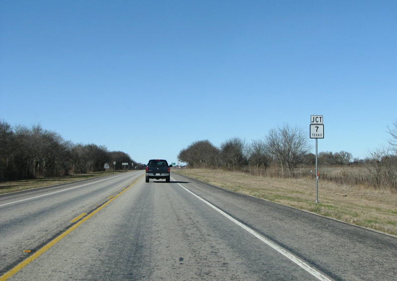 |
US 77's next major northbound intersection is with SH 7. Photo taken 01/01/08. |
 |
SH 7 ends at IH 35 to the west and connects it with the large town of Marlin to the east, then Nacogdoches and eventually Louisiana. Although it is not signed, this begins a very short overlap for US 77 with SH 7. 777, more numerical alliteration. Photo taken 01/01/08. |
 |
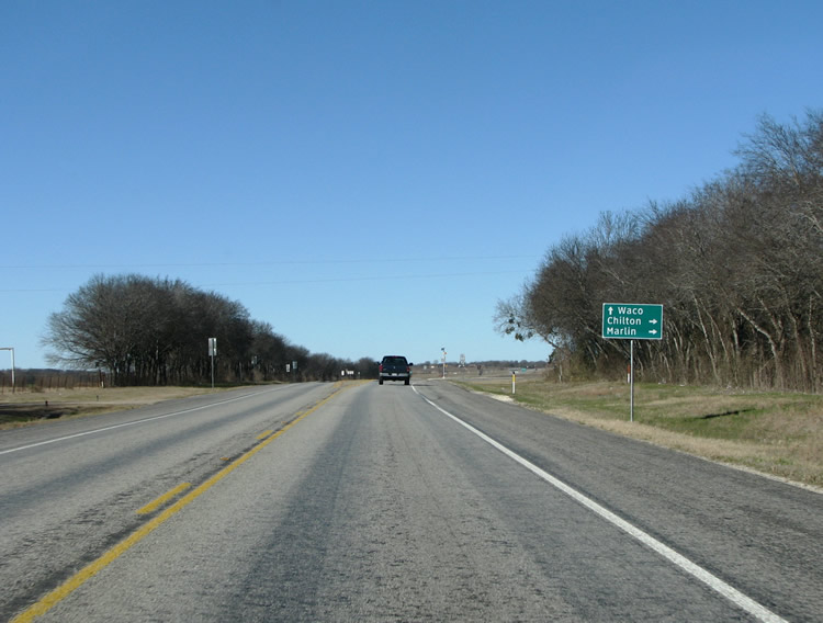
US 77 northbound at SH 7 near Chilton. Photo taken 01/01/08. |
 |
As noted before, the SH 7 and US 77 overlap at Chilton is not signed along the US highway. Photo taken 01/01/08. |
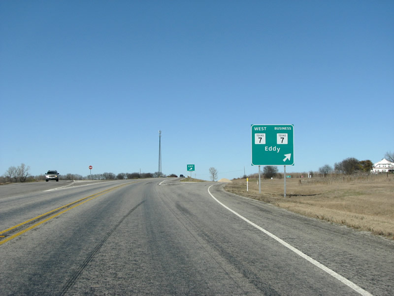 |
US 77 northbound as SH 7 exits to continue to IH 35 westbound. Turning right on the offramp will allow motorists to use Business SH 7 through Chilton, and connect with SH 7 eastbound. The business route was created in 1991 along with the diamond interchange with US 77. Photo taken 01/01/08. |
 |
US 77 northbound past Chilton. Photo taken 01/01/08. |
 |
The next town along US 77 is Golinda, which straddles the county line between Falls and McClennan. The town was named for the Mexican priest Ignacio Galindo, who received a large land grant in the area. Golinda now marks the very outer edge of the Waco area. Photo taken 01/01/08. |
 |
US 77 northbound at Golinda enters McLennan County. This style of county line sign is older and is slowly being replaced by the clearview style which could be seen further to the south. Photo taken 01/01/08. |
 |
As it enters McClennan County, US 77 gaines lanes in each direction. This view looks northbound past Golinda. Photo taken 01/01/08. |
 |
The first large intersection and light in the Waco area is Moonlight Dr, also known as FM 3148. This road connects US 77 with IH 35 and the suburb of Hewitt to the west. Photo taken 01/01/08. |
 |
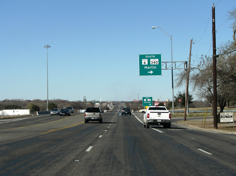
As it passes through Robinson, a suburb of Waco, US 77 takes on a more urban feel with many businesses and traffic lights. Here, the road prepares to meet Waco's Loop 340 and SH 6. This marks the outer edge of Waco proper. Photo taken 01/01/08. |
 |
US 77 northbound at the loop in Waco. This cloverleaf interchange connects with the east loop of the city, which was recently upgraded to freeway. A portion of Waco's skyline can be seen in the background of this photo. Photo taken 01/01/08. |
 |
US 77 northbound enters Waco just inside the loop. Photo taken 01/01/08. |
 |
As it enters the southeast side of Waco, US 77 drivers must navigate a large roundabout. Photo taken 01/01/08. |
 |
A view of the roundabout. Photo taken 01/01/08. |
 |
In Texas, roundabouts are known as traffic circles. Until IH 35 was constructed in the early 1960s, drivers between Dallas-Fort Worth and Austin and San Antonio had to navigate this traffic circle. The intense amount of traffic meant that the circle was frequently backed up with very long delays. A burger joint on the side of road became famous for selling T-shirts that said "I survived the circle". With the construction of the nearby interstate, traffic counts declined so that the circle is now just another minor part of Waco. Photo taken 01/01/08. |
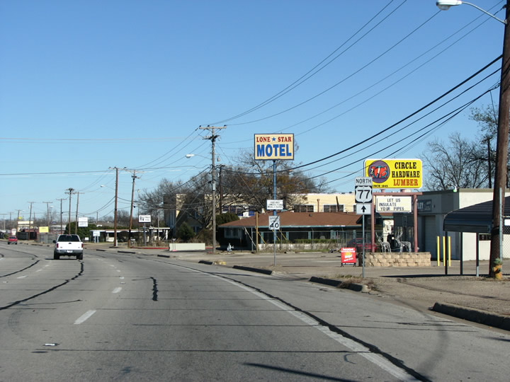 |
US 77 transitions to an urban street in Waco, LaSalle Avenue. This used to be the main route through town, and there are many old pre-interstate buildings gracing the street. Photo taken 01/01/08. |
 |
The first mention of IH 35 is a few blocks north of the traffic circle on LaSalle Avenue. US 77 drivers must turn left here to make it to the freeway. Although it is not mentioned here, continuing straight will put motorists on US 77 business. Texas is notoriously bad for signing US highways in metropolitan areas, and many times they simply dissapear. Photo taken 01/01/08. |
 |
After turning left on US 77 in Waco to get to IH 35, it has dissapeared after all. IH 35 is the only route mentioned at this intersection. Continuing straight ahead will put motorists onto Loop 2, into downtown Waco. Photo taken 01/01/08. |
 |
Another view of the US 77 / IH 35 intersection in Waco. IH 35 was renamed after local car dealer and good roads president Jack Kultgen in 1967. Photo taken 01/01/08. |
 |
US 77 appears again on the onramp to IH 35 northbound headed towards Dallas. The freeway is concurrent with US 77 until Hillsboro, to the north. For much of the rest of its journey through Texas, US 77 dissapears and is quietly overlapped with IH 35 and IH 35E. Photo taken 01/01/08. |


Page Updated January 12, 2008.
|
About Contact FAQ |
Spotlights Testimonials Interstate Guide |
Social Media:
 |
|
© 2000-23 AARoads.com | All Rights Reserved | Privacy Policy / Terms of Use
|
||